|
Bartholomew
Bartholomew's Revised Half Inch Contoured Map Of Great Britain - Sheet 21 - Suffolk
Edinburgh: John Bartholomew 1948. Revised. Paperback. Very Good. Clean colour fold out map mounted on paper. Sheet 21 in the Bartholomew's series. Blue cover. Minor wear and tears including a couple slightly larger ones which are repairable if wished Good for its age <br/><br/> John Bartholomew paperback
Bookseller reference : 2268
|
|
|
Bartholomew Maps
London Westminster to the City Map - 9 Inches to the Mile by Bartholomew Maps
Bartholomew Maps. Paperback. Good. Binding: Paperback ---Publisher: Bartholomew Maps ---Date: 1963 ---Edition: ---Pages: ---Condition: Good ---DJ Condition: --- Description: The map is unmarked no stamps or inscriptions the only flaws are a couple of minor scuffs to the covers. . MOST OF OUR BOOKS ARE SHIPPED WITHIN 1 WORKING DAY OF PURCHASE. If not already present high quality photographs of any of our titles can be provided by request via e-mail. Bartholomew Maps paperback
Bookseller reference : SKU1005991
|
|
|
Bartholomew John G maps
The Times Comprehensive Atlas of the World. 12th Edition. 2008
London: The Times Book Group. VG: in very good condition with slipcase. 2008. 12th Edition reprint. Illustrated hardback laminated board cover. 460mm x 320mm 18" x 13". 67pp 224pp plates. Colour maps. . The Times Book Group hardcover
Bookseller reference : ta-008 ISBN : 0007801505 9780007801503

|
|
|
Bartholomew John G maps
The Times Comprehensive Atlas of the World. 10th Edition. 2001
London: The Times Book Group. VG: in very good condition with dust jacket and silver/black slipcase. Jacket and slip case lightly rubbed. 2001. 10th Edition reprint. Black hardback cloth cover. 460mm x 320mm 18" x 13". 124 plates; 220pp. 320 colour plates. . The Times Book Group hardcover
Bookseller reference : ta-001 ISBN : 0723007926 9780723007920

|
|
|
Bartholomew
Bartholomew's Quarter Inch Map of Ireland : Sheet 4 - Cork and Killarney
No marks or inscriptions. Two secitions slightly sunned. A little tearing along most exposed vertical fold. Some exposure of the linen but still intact along some other folds. 1pp. Folded linen-backed vintage map of Cork and Killarney opens up to 23 x 33 inches. Undated ca 1950s. Compass north bearing date 1948.
|
|
|
Bartholomew
Bartholomew's Quarter Inch Map of Ireland : Sheet 5 - Galway - Mayo
No marks or inscriptions. A little very slightl sunning. Intact map with no tears. 1pp. Folded linen-backed vintage map of Galway and Mayo opens up to 23 x 33 inches. Undated ca 1950s. Compass north bearing date 1951.
|
|
|
Bartholomew
World travel map Israel with Jordan. Scale 1:350000.
Bartholomew, Edinburgh 1971. Farbige gefaltete Karte. Ca. 66 x 86 cm (bxh). Geringe Gebrsp.
Bookseller reference : 10980
|
|
|
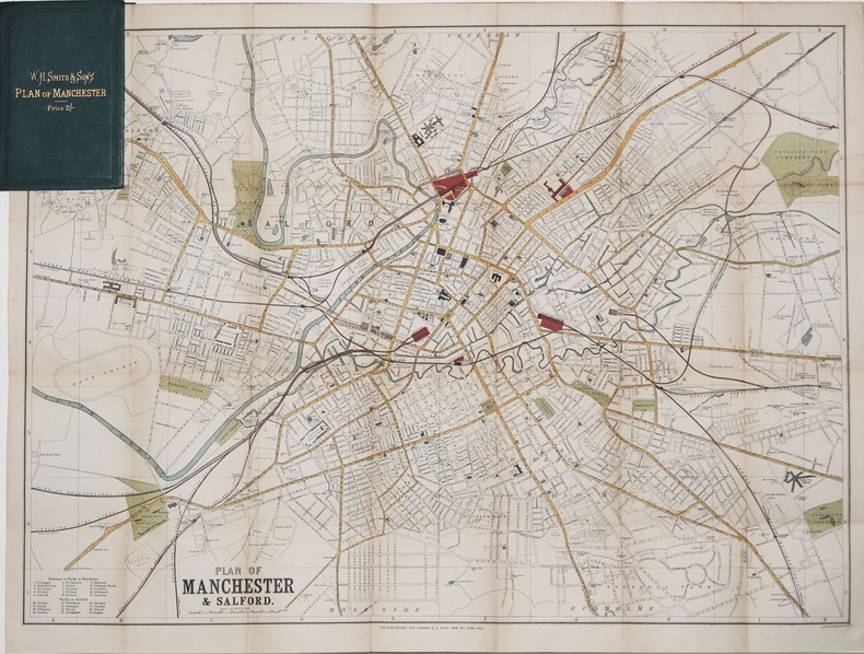
BARTHOLOMEW (John).
[MANCHESTER] Plan of Manchester & Salford.
[circa 1890]. 500 x 680 mm ; replié et monté dans une reliure de percaline verte de l'éditeur W.H. Smith & Sons contenant l'index des rues (16,2 x 10,5 cm).
Bookseller reference : LBW-3270
|
|
|
BARTHOLOMEW'S RAILWAY MAP.
Bartholomew's Railway Map of the British Isles showing the New Grouping. Each Group distinuished by a Separate Colour. [Scale Nineteen Miles to One Inch.] BRIGHT, CLEAN COPY
8vo., folding coloured map on cloth measuring 34.5 x 29 inches (approx. 88 x 74 cms) folding in 24 panels to 9.5 inches (approx. 23 x 13 cms); wrappers lettered in red and black, certain folds neatly reinforced, some mild age-soiling and rubbing else a very good, bright, clean copy. VERY SCARCE IN THIS CONDITION.
|
|
|
BARTHÉLEMY (J.E.).
Plan géométrique (en deux feuilles) des bois dépendants du domaine de Tigery appartenants à Madame de Clermont-Tonnerre. Dressé par J.E. Barthélemy, géomètre à Corbeil, d'après les réarpentages successifs faits depuis 1843 inclusivement (à l'exception de l'année 1851).
1864. In-folio ; demi-percaline noire, dos lisse muet, pièce de titre de maroquin rouge sur le premier plat (reliure de l'époque).
Bookseller reference : LBW-6635

|
|
|
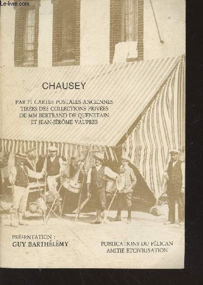
Barthélémy Guy
Chausey par 71 cartes postales anciennes tirées des collections privées de MM Bertrand de Quenetain et Jean-Jérôme Vaupres
Pélican Amitié et Civilisation. Non daté. In-8. Broché. Bon état, Couv. convenable, Dos satisfaisant, Intérieur frais. 54 pages augmentées de nombreuses photos de cartes postales en noir et blanc hors texte.. . . . Classification Dewey : 741.68-Illustrations des cartes postales
Bookseller reference : RO20213371
|
|
|
BARTRAM, William
Voyage dans les parties sud de l’Amérique septentrionale
In -8°, due volumi, pp. 457 con due tavole ripiegate, pp. 436 con 1 tavola ripiegata e grande carta geografica pieghevole a cura di J.B. Poirson e stampata da Blondeau, legatura in pelle, con tasselli e titolo al dorso. Nel secondo volume manca la quarta tavola ripiegata, tavola non presente in tutti gli esemplari (v. Stafleu & Cowan, 329 ed. fr.); all’antiporta del primo vol. illustrazione con Mico Chlucco, il Gran Guerriero o il Re dei Seminole. Prima edizione francese. Particolarmente dettagliata la carta geografica, importante per capire il livello di accuratezza raggiunto dalle esplorazioni scientifiche. In -8°, two volumes, pp. 457, with two large folded plates, pp. 436 with 1 folded plate and large folded map by J.B. Poirson and engraved by Blondeau, leather binding with title at the back. In the second volume the fourth folded plate is missing which is not existing in each copy, (see Stafleu & Cowan, 329 ed. fr.). At the frontispice of the first volume portrait of Mico Chlucco, the Great Warrior or the King of Seminoles. First French edition.
|
|
|
Based On The Esso Petroleum Companys Eight Road Maps Of Britain And Ireland.
Ancestral Britain: Pictorial Guide & Highway Maps
A.P.S.O. Ltd 1953. Paperback. Used; Good. <p><i><strong>Fast Dispatch. Expedited UK Delivery Available. Excellent Customer Service. </strong></i> <br/><br/>Bookbarn International Inventory #2300382</p> A.P.S.O. Ltd paperback
Bookseller reference : 2300382
|
|
|
BASEQUE L.
Construction des cartes de l'?tat-major (en Fran?e et en Belgique) et coordon?es rectilignes. Calculs tr?s simple des distance ? vol d'oiseau. A l'usage de l'enseignement, l'a?rostation, l'aviation et la colombophilie.
Broch?. 71 pages.
|
|
|
Basil Mathews . with Seventeen Illustrations by Ernest Prater Twenty Four Other Pictures and Photographs and Three Maps
Livingstone the Pathfinder by Basil Mathews . with Seventeen Illustrations by Ernest Prater Twenty-Four Other Pictures and Photographs and Three Maps
Missionary Education Movement Of The United States And Canada. Hardcover. Good. Binding: Hardback ---Publisher: Missionary Education Movement Of The United States And Canada ---Date: 1912 ---Edition: ---Pages: 211 ---Condition: Fair ---DJ Condition: None --- Description: All of the pages are unmarked uncreased and tightly bound the only flaws are some scuffs and light rubbing to the boards and spine and an inscription to the front endpaper and another to the inside front cover. MOST OF OUR BOOKS ARE SHIPPED WITHIN 1 WORKING DAY OF PURCHASE. WE UPLOAD A SELECTION OF HIGH QUALITY PHOTOGRAPHS WITH EACH LISTING HOWEVER IF NOT ALREADY PRESENT PHOTOGRAPHS OF ANY OF OUR TITLES CAN BE PROVIDED BY REQUEST VIA E-MAIL.--- P --- 488 Missionary Education Movement Of The United States And Canada hardcover
Bookseller reference : SKU1038797

|
|
|
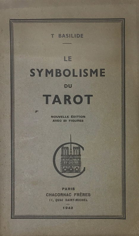
Basilide (Patrice Genty, 1883-1964, consacré évêque de l'Eglise Gnostique sous le nom de Taur) :
Symbolisme (Le) du Tarot. Nouvelle édition avec des figures.
Paris, Chacornac, 1942 ; in-8, brché ; (1) f. blanc, 53, (1) pp., couverture vert-olive imprimée en vert foncé.
Bookseller reference : 15259
|
|
|
Basse Seine
carte Basse Seine au 1/10 000e de Paris a Rouen
IN4 1950,2e edition,carte coloriée depliante en accordeon d’un sel tenant de Bougival a Tourville(Rouen),tres rare,complet,pres de 100Km de berges,
Bookseller reference : 17045
|
|
|
BASSET
Rome
Questo panorama di Roma risulta essere una copia di quello edito da Chereau intorno al 1730 circa. L’assenza del porto di Ripetta e della scalinata di Trinità dei Monti permette di datare il paesaggio ritratto al 1700 circa. La raffigurazione di San Pietro ricorda quella del Barriere che è forse da ritenersi il lontano prototipo di questa serie di vedute edite in Francia nel XVIII secolo.Di questa incisione è nota una variante, censita da Marigliani, che reca in basso l’indirizzo di François Basset, e la cui edizione risale al 1780 circa.È quindi possibile suppore che questo sia il primo stato della lastra, avanti l’indirizzo editoriale, oppure che Basset abbia successivamente acquisito il rame e pubblicato con l’aggiunta del proprio indirizzo.Incisione in rame, finemente colorata d'epoca, in basso tre righe di testo in francese e legenda numerica 1-16, in ottimo stato di conservazione. This panoramic view of Rome is a copy of the one published by Chereau around 1730 or so. The absence of the port of Ripetta and the stairway of Trinità dei Monti allows us to date the landscape portrayed to around 1700. The depiction of Saint Peter recalls that of the Barriere which is perhaps to be considered the prototype of this series of views published in France in the eighteenth century.Marigliani describes a copy bearing the address of François Basset below, and whose edition dates back to around 1780.It is therefore possible to suppose that this is the first state of the plate, before the editorial address, or that Basset has subsequently acquired the plate and then published it with the addition of his own address.Copper engraving, finely colored at the time, three lines of text in French at the bottom and numerical key 1-16, in excellent condition. C. Marigliani, "Le Piante di Roma delle collezioni private", tav. 174 (variante)

|
|
|
BASSET (André).
[NOTRE-DAME de PARIS] Vue perspective de l'intérieur de l'église de Notre Dame de Paris.
[circa 1780]. 280 x 390 mm.
Bookseller reference : LBW-5770

|
|
|
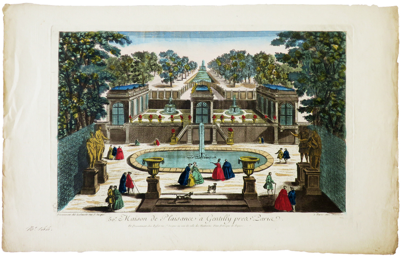
BASSET (Paul André).
[GENTILLY] 50e. Maison de plaisance à Gentilly près Paris.
Paris, Daumont, Lachaussée puis Basset, [circa 1780]. 270 x 395 mm.
Bookseller reference : LBW-6270
|
|
|
BASSET (Paul André).
[JEU de l'OIE] Nouveau Jeu historique et chronologique de la Monarchie française.
Paris, Basset, [1815]. 454 x 605 mm.
Bookseller reference : LBW-8528

|
|
|
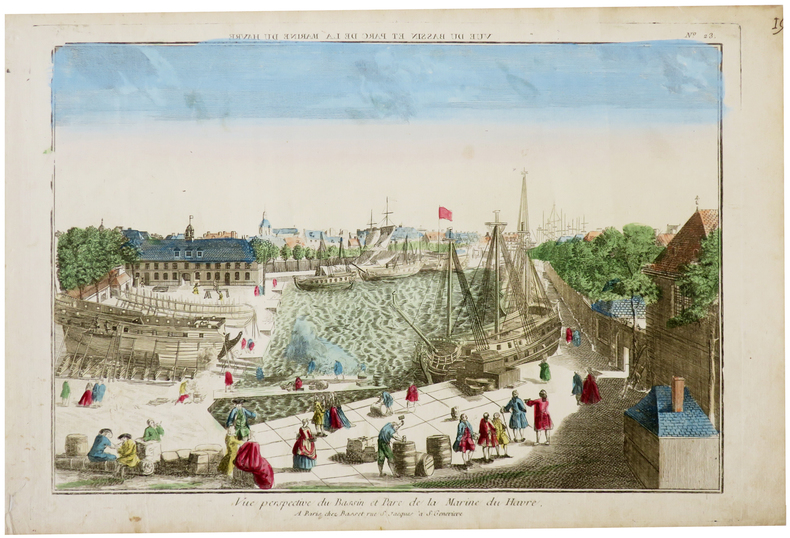
BASSET (Paul André).
[LE HAVRE] Vue perspective du bassin et parc de la Marine du Havre.
Paris, Basset, [circa 1760]. 286 x 398 mm.
Bookseller reference : LBW-6286
|
|
|
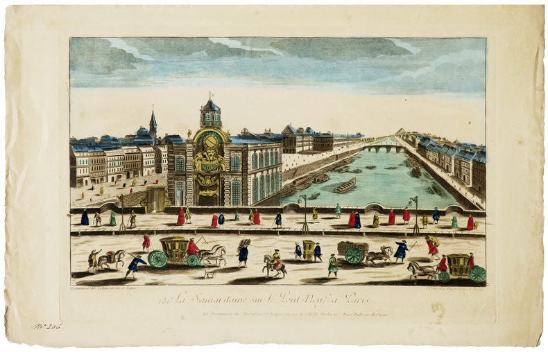
BASSET (Paul André).
[SAMARITAINE] 131e. La Samaritaine sur le Pont-Neuf à Paris.
Paris, Daumont, Lachaussée puis Basset, [circa 1780]. 284 x 420 mm.
Bookseller reference : LBW-6280
|
|
|
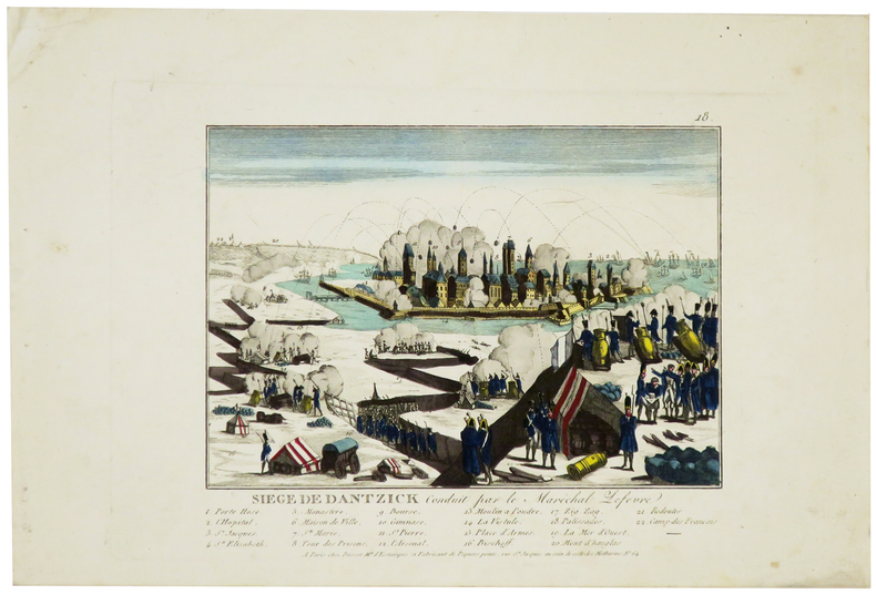
BASSET (Paul André).
[SIÈGE de GDANSK] Siège de Dantzick conduit par le maréchal Lefèvre.
Paris, Basset, [1807]. 170 x 197 mm.
Bookseller reference : LBW-5965
|
|
|
BASSET (Paul André).
Carte de la France tracée d'après les nouvelles limites fixée par le Traité de Paix du 20 novembre 1815.
Paris, Basset, 1816. 477 x 680 mm.
Bookseller reference : LBW-3688

|
|
|
Bassett Marnie; Maps on End Paers Illustrator
Letters From New Guinea 1921. With a Postscript and some Notes added in 1969 SIGNED & Insc By Author
Hawthorn Press 1969-01-01. Hardcover. Like New. NICE CONDITION HARDCOVER BOOK IN DUST JACKET. NO WRITING OR MARKINGS IN TEXT. SLIGHT WEAR TO COVER. LIGHT WEAR TO DUST JACKET. A CLEAN & SOLID BOOK. Hawthorn Press hardcover
Bookseller reference : Z-6046
|
|
|
Bassett, Thomas J.; Seager, Joni; Rokeach, Barrie; Horowitz, Helen Lefkowitz; Nemeth, David; Ricciotti, Dominic; Todhunter, Rodger; Ford, Larry R.; griffin, Ernst
Landscape, Volume 25, Number 2, 1981
48 pages. Features: Reaping on the Margins; - a century of community gardening in America; Push Over, Paradigm; Light Winds Aloft; Seeing Ourselves Through The Bars - A Historical Tour of American Zoos; 'Bright Yard' Maps from Cheju Island; Symbols and Monuments - Images of the Skyscraper in American Art; Banff and The Canadian National Park Idea; Chicano Park - Personalizing an Institutional Landscape. Moderate wear. Unmarked. A sound copy. Book

|
|
|
BASSIN HOUILLER DE L’AVEYRON
Concession de MAZEL, BASSIN HOUILLER DE L’AVEYRON, documents historiques originaux
1860 S.L.,S.d.,vers 1859 / 1860;IN4 broché,texte en lithographie manuscrite : 23p.+ plans et cartes dont trés grande carte dépliante coloriée des lignes de chemins de fer de l’epoque,1- coupe synthétique du bassin houiller d’Aubin a Decazeville,1bis-coupe geologique, 2- carte geologique dépliante du bassin, 3-profil de la grande couche du MAZEL depliante,4- trés grande carte dépliante coloriée des lignes de chemins de fer de France de l’époque avec légendes manuscrites,
Bookseller reference : 21459
|
|
|
Bateman, M. (editor)
Atlas of Portsmouth
A very large book. No marks or inscriptions. Minor creasing to some page corners. A clean copy with sound ring binding, slightly dusty slightly sunned unmarked boards with a little peeling to the reinforcing laminate on the boards. Unpaginated. ca 140pp. Mainly a series of maps and associated text showing the statistics applicable to Portsmouth in terms of Administration, Physical Background, Historical Development, Economic Structure & Social Facilities, Census and Community Analysis and Contemporary Growth and Change. Plus a fair number of photographs of the area showing the features referred to in the maps and text.

|
|
|
Bates, A. J. (editor)
The Book of Nottingham (1938) : Presented to the Delegates at the Annual Conference of the National Association of Head Teachers
No marks or inscriptions. No creasing to covers or to spine. Very clean pages in a tight binding with bright unmarked boards, very clear gilt embossing and lettering to front and spine, dusty top to page edges and no bumping to corners. 178pp. Limited Edition of 550 copies. Published for the 1938 Annual Conference of the NAHT, this work covers a wealth of information about Nottingham including its history, education, municipal life, geography, university, lace making, Southwell Minster, industry, and castle.

|
|
|
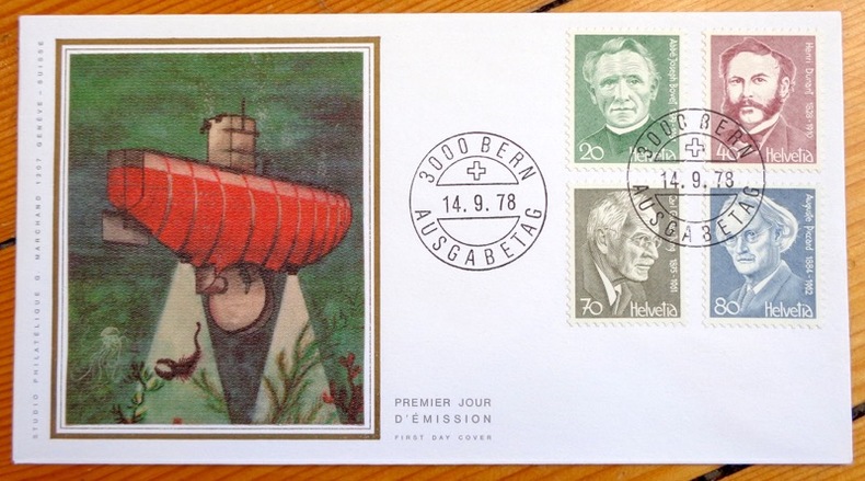
Bathyscaphe. Abbé Bovet - Henri Dunant - Carl G. Jung - Auguste Piccard:
Enveloppe philatélique.
Studio philatélique G. Marchand, 1978. Enveloppe au format 16,6 x 9 cm., ornée d'une belle vignette en soie représentant le Bathyscaphe et d'un bloc de 4 timbres, affranchissement philatélique, premier jour d'émission. A l'état de neuf.
Bookseller reference : 4857
|
|
|
Battle of Jutland.
NARRATIVE OF THE BATTLE OF JUTLAND.
pp. iv, 121+ Plus forty-five full page military diagrams of the battle, some folding. Inked ownership. Tall 8vo. Original full blue cloth binding, gold lettered. Extremities slightly worn. Some spotting on boards. Nice copy. WWI 8
|
|
|
BAUD BOVY Daniel:
L'évasion. Récit de deux prisonniers français évadés du camp d'Hammelbourg.
Paris, librairie militaire Berger-Levrault,collection La Guerre - Les récit des témoins, 1917. In-12 broché de [2]-XV-[1]-218 pages.
Bookseller reference : 20470

|
|
|
BAUD Henri; MARIOTTE Jean-Yves:
Histoire des communes savoyardes. Tome I: Le Chablais.
Roanne, Editions Horvath, 1980. In-8 de 422 pages, cartonnage d'éditeur brun illustré. Usure de la couche plastifiée aux plis de la couverture.
Bookseller reference : 17248
|
|
|
BAUDET
Nouvelle encyclopédie illustrée de la carte postale internationale, volume 2
sd (1979?), édition Joël Garcia, Trouvailles, in-4 pleine percaline rouge de 388 pages, titrage doré, une vignette couleurs sur le premier plat, nombreuses illustrations couleurs et noir et blanc. | Etat : Bon état général, salissures sur le 4ème plat (Ref.: J6932, G923)
Bookseller reference : 18367
|
|
|
BAUDET
Nouvelle encyclopédie illustrée de la carte postale internationale, volume 2
1980, édition Joël Garcia, Trouvailles, in-4 cartonné de 388 pages, couverture skyvertex rouge, titrage doré, une vignette couleurs sur le premier plat, nombreuses illustrations couleurs et noir et blanc. | Etat : Bon état général, couverture un peu défraîchie avec une petite tâche sur la vignette, petit accroc sur le dos (Ref.: G5449)
Bookseller reference : 2916358046
|
|
|
Baudet
Toute la Bretagne en cartes postales Volume III en 2 tomes
2 tomes in-4 en bon état émoussés sur les bords 376 + 113 pages
Bookseller reference : yam0190

|
|
|
BAUDET (Annie et François).-
Encyclopédie internationale de la carte postale. 1er volume 1978.
1978 Paris, S.N.R.A., 1978, in 4° broché, 353 pages.
Bookseller reference : 79596
|
|
|
Baudet Annie et François
L'encyclopédie internationale de la carte postale illustrée - 1er volume.
S.n.r.a. éditeurs. 1978. In-4. Broché. Etat d'usage, Coins frottés, Dos satisfaisant, Intérieur frais. 351 pages - nombreuses reproductions de cartes en couleurs et en noir et blanc dans et hors texte.. . . . Classification Dewey : 741.68-Illustrations des cartes postales
Bookseller reference : R320176154

|
|
|
Baudez Claude F.; Pierre Becquelin B/w Illustrations Maps
Archeologie de Los Naranjos Honduras Etudes mesoamericaines
Mission Archeologique et Ethnologique Francaise au Mexique 1973. Price HAS BEEN REDUCED by 10% until Monday June 29 sale item 438 pp. plates some of which are folding folding map in rear pocket hardcover fine in a very good dust jacket Mission Archeologique et Ethnologique Francaise au Mexique hardcover
Bookseller reference : ZB1065696
|
|
|
Baudisova Monika Trilla Jordi Palenicek Jean-Gaspard
Picnic japonais
ACTES SUD 2019 120 pages 19 4x25x1 8cm. 2019. Broché. 120 pages.
Bookseller reference : 500122991

|
|
|
BAUDOT Marcel, BERNARD Henri, BRUGMANS Hendrik et alii
Encyclopédie de la guerre 1939-1945.
Tournai, Casterman, 1977. 17 x 25, 440 pp., nombreuses cartes, reliure pleine toile d'édition + jaquette, bon état.
Bookseller reference : 31195
|
|
|
Bauer Helen SIGNED & INSCRIBED Illustrated w/fotos Linecuts & Maps By Bruce McCurdy
Hawaii the Aloha State
Doubleday Garden City 1960. HBDJ minor rub & chip on edges dj 1960 1st edition 2 IN. piece missing from back dj VG/VG-. Signed by Author. Hard Cover. Doubleday, Garden City hardcover
Bookseller reference : 2817
|
|
|
Baughman Robert W.
KANSAS IN MAPS
Topeka: Kansas State Historical Society 1961. First edition. hardcover. Very good . 4to. Quarter faux marbled vellum over patterned boards gilt spine title. Decorated end papers. 104 pages Illustrated with color and b/w maps. Number 45 of the deluxe limited edition of 200. No names or marks. In illustrated slip case which is edge worn. No dust-jacket as issued. <br/><br/> Kansas State Historical Society hardcover
Bookseller reference : 1353
|
|
|
Baumgarten, F. G. - Schropp, Simon [Hrsg.]
Karte vom Fürstenthum Ansbach oder Onolzbach oder Burggrafthum unterhalb des Gebürges (Principatus Onoldinus) nach besten Hülfsquellen entworffen und mit Aprobation der Königl. Acad.der Wiss. zu Berlin herausgegeben 1792. Corrig. v. S. [Altkolorierter Original-Kupferstich / original colored copper engraving].
o.J. [2 Warenabbildungen]
Bookseller reference : 12045DB

|
|
|
Baumgarten, Ya'aqov
Archaeological Survey of Israel: Map of Shivta (166)
IN HEBREW AND ENGLISH. Contains a map. 24x17 cm. 116+91 pages. Softcover. In good condition.
|
|
|
BAURON Abbé P:
De Carthage au Sahara.
Tours, Alfred Mame et fils, 1893. 1 vol. in-8 de 301 pages, pleine percaline rouge d’éditeur, dos et plats richement ornés, tranches dorées. Mors légèrement fendus. coiffes frottées.
Bookseller reference : 2153

|
|
|
BAUTRAIT M.J.
Si Chilly m'était conté. Historique de Chilly-Mazarin.
Le Mée-sur-Seine, Amatteis, 1987, un volume in-8 broché, couv. illustrée, 182 pages, avec 110 illustrations, photos, cartes postales, cartes, plans, dessins de Henri Carette, tirage limité à 2000 exemplaires ( celui-ci n° 1573/2000). Bon état.
Bookseller reference : 7049
|
|
|
Baxter, John, et al
Scotland Highlands and Islands
No marks or inscriptions. No creasing to covers or to spine. A lovely clean very tight copy with bright unmarked boards and no bumping to corners. 128pp.

|
|
|
BAYARD (Dominique). MANUSCRIT.
Carte agricole du département de la Haute Garonne. Où sont indiquées, par des teintes conventionnelles, les diverses natures de la couche végétale des terrains dont il se compose.
1853. 950 x 1135 mm, sur papier marouflé sur toile de lin, avec un galon noir cousu en bordures haute et basse.
Bookseller reference : LBW-4166

|
|
 Receive by email
 Download as PDF document
 RSS feed


