|
Jones (M. Whitmore)
Popular Games of Patience , 45 of the Best Games clearly described and illustrated
Bazaar, Exchange and Mart Malicorne sur Sarthe, 72, Pays de la Loire, France 1922 Book condition, Etat : Très bon relié, toile In-12 1 vol. - 166 pages
Bookseller reference : 1739
|
|
|
Jonathan Krisch SIGNED BY Author Maps by Mapping Specialists Ltd
Moses a Life
Ballantine Books Fawcett Columbine NY 1998. HBDJ November 1998 stated 1st edition NF/NF. Signed by Author. First Edition. Hard Cover. Ballantine Books Fawcett Columbine NY hardcover
Bookseller reference : 5690
|
|
|
JONES JAMES J.; HOWARD YOUNG & CLINTON BOUTWELL WITH MAPS AND CHARTS BY KEN CARLSON
Voices Of Latin Cultures And Ancient Civilizations
Leswing Communications San Francisco for Stone Educational Publications Chicago: 1971. Hardcover no dustjacket. Very good condition. Covers the Latin Cultures of Mexico Spain Brazil and Ancient Egyptian Chinese and African Civilizations. Includes an Index. Leswing Communications, San Francisco for Stone Educational Publications, Chicago: 1971 hardcover
Bookseller reference : 88584X1
|
|
|
Jones Barbara - William Ouellette (Hrsgg.)
Erotische Postkarten.
Köln, DuMont, 1977. 4°. 127 S. mit zahlreichen, vielfach farb. Abbildungen. Farb. illustr. Orig.-Broschur.
Bookseller reference : 3117B
|
|
|
Jones, Emrys (consultant editor)
The Atlas of World Geography
Illustrated, 112 maps, index of place names, previous owner gift message on the prelims. eng
|
|
|
Jones, Lawrence F.; George Lonn; Roy M. Longo
Historical Highlights of Canadian Mining Including Canadian Personalities
A clean, unmarked book with a tight binding. Full blue cloth boards. Slight edge wear. 8 1/4"w x 10 3/8"h. 274 pages. Many b&w photos and illustrations.

|
|
|
Jordan D. & V. Kellogg; Maps Drawings Photos Illustrator
ANIMAL LIFE. A FIRST BOOK OF ZOOLOGY
D. Appleton & Co 1900-01-01. Hardcover. Acceptable. D. Appleton & Co hardcover
Bookseller reference : 150424016
|
|
|
Jordan David; Showalter Dennis foreword and Photographs Maps & Artwork
The Balkans Italy & Africa 1914 - 1918 The History of World War I
Jan 01 2008. Hardcover. Fine. hardcover
Bookseller reference : 99-TH6O-SIEV
|
|
|
Jordan Robert 1948 2007 James Oliver Rigney Jr. ; Patterson Teresa. ; Hamilton Todd Cameron. maps and ornaments by Ellisa Mi
The World of Robert Jordan's The Wheel of Time.
New York : Tor 1997. 1997. Very Good. 1st ed. 1st printing ; 304 pp. : illustrated maps ; 29 cm. ; OCLC: 36841307 ; ISBN: 0312862199 ; LCCN: 97-13271 ; includes 70 paintings and maps with double-page spreads of the seven book jackets by Darrell K. Sweet ; white cloth in illustrated dustjacket ; "The Wheel of Time-its most recent volume The Path of Daggers a #1 New York Times and international bestseller- is the most extraordinary work of American fantasy ever published. Its popularity is immense; its quality is dazzling. And its world has indeed taken on a fictive reality for its millions of readers. Over fourscore new full color paintings include stunning new maps of the world portraits of the central characters landscapes objects of Power and national flags. The reader will learn about the exotic beasts used by the Seanchan and read of the rise and fall of Artur Hawking peruse the deeper story of the War of the Shadow. Here is the tale of the founding of the White Tower and the creation of the Ajahs. The inner workings of the closed country Shara are revealed as is the existence of a hitherto unknown continent called The Land of the Madmen. This stunning volume also includes double-page spreads of the seven book jackets by Darrell Sweet so that the art can be enjoyed without type and all the known maps of the world including maps of the Seanchan Empire the nations of the Covenant of the Ten Nations and the nations as they were when Artur Paendrag Tanreall began his rise to legend." ; remains of label to front dustjacket else VG/VG New York : Tor, 1997. hardcover
Bookseller reference : 3239

|
|
|
JOSE Marie; BENEDETTO Croce (préface):
La maison de Savoie. Les origines. Le Comte Vert - Le Comte Rouge.
Paris, Editions Albin Michel, 1956. 3 volumes in-8 brochés de 425, 446 et 373 pages, couvertures illustrées en couleurs. Coins frottés et dos usés, tampon de possesseur sur la page de titre du premier volume.
Bookseller reference : 17275
|
|
|
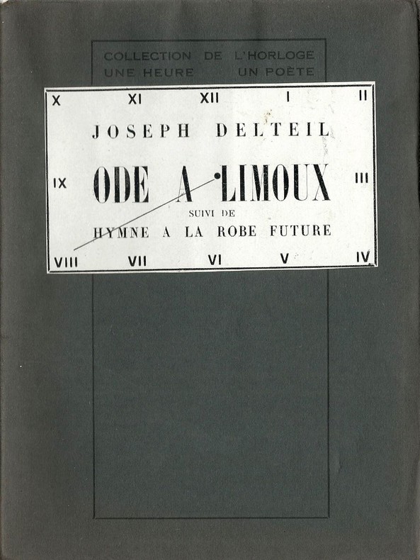
Joseph Delteil.
Ode à Limoux suivi de Hymne à la Robe Future. ( Tirage numéroté sur hollande avec carte postale de Limoux dédicacée par Joseph Delteil à André Clément Marot ).
Editions des Cahiers libres / Collection de l'Horloge - Une Heure, un Poète n° 8 de 1927. In-12 broché non paginé au format 14,5 x 19,5 cm. Couvertures bleues rempliées,avec vignette de titre collée au 1er plat, représentant un cadran d'horloge, indiquant le numéro de l'oeuvre dans la série. Dos carré. Plats et intérieur frais, malgré quelques rousseurs. Un des 200 exemplaires n° sur hollande de rives ( n° 129 ). Superbe état général. Rare édition originale à laquelle on joint une carte postale de Limoux expédiée et dédicacée par Joseph Delteil à André Clément Marot.
Bookseller reference : 1908
|
|
|
Joseph-Nicholas Delisle
Terrae Sanctae Tabula e Scripturae Sacrae, Flavii Josephi Eusebii et Divi Heironymi . . . Anno MDCCLXIII (2 sheet map of the Holy Land)
Bordeaux Lattré 1771 carte ancienne enn deux feuilles, colorée d'époque en vert , rouge et jaune, cartouche non coloré, par Joseph-Nicholas Delisle, gravée par Arrivet. Format total : 50 centimètres de haut par 39 centimètres de large, 1771 Bordeaux Lattré Editeur,
Bookseller reference : 27627
|
|
|
Josephy Jr. Alvin M./Colbert George maps
The Civil War in the American West Vintage Civil War Library series
NY: Vintage Books 1991. 1st paperback printing. VG. xiv 448 p. maps notes biblio index trade paperback; Vintage Books paperback
Bookseller reference : 26064 ISBN : 0679740031 9780679740032

|
|
|
JOUVIN de ROCHEFORT (Albert).
[TOULOUSE] Plan de Tolose divisé en huict capitoulats.
Paris, de Fer, [1679]. 500 x 608 mm.
Bookseller reference : LBW-3042

|
|
|
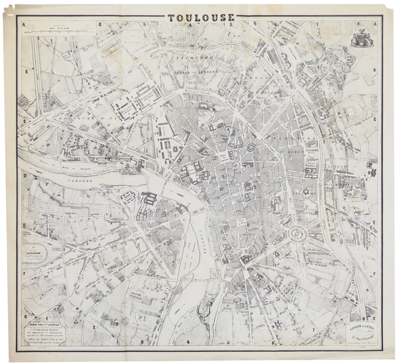
JOURDAN (Justin).
[TOULOUSE] Toulouse.
1869. 480 x 522 mm.
Bookseller reference : LBW-6389
|
|
|
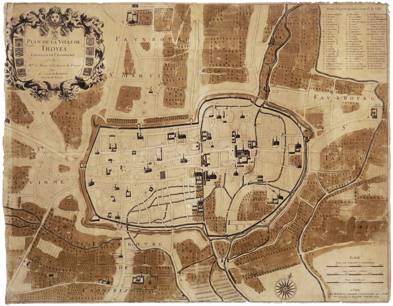
JOUVIN de ROCHEFORT (Albert).
[TROYES] Plan de la ville de Troyes capitalle de Champagne.
Paris, H. Jaillot, 1679. 457 x 587 mm.
Bookseller reference : LBW-6502
|
|
|
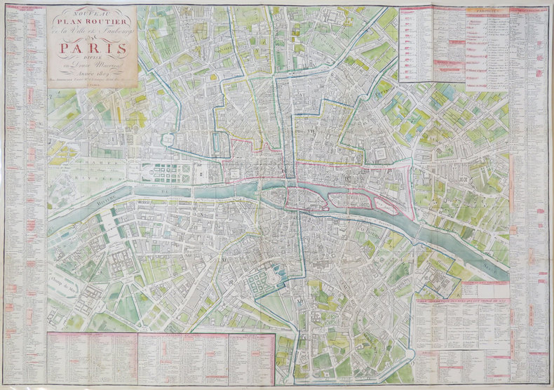
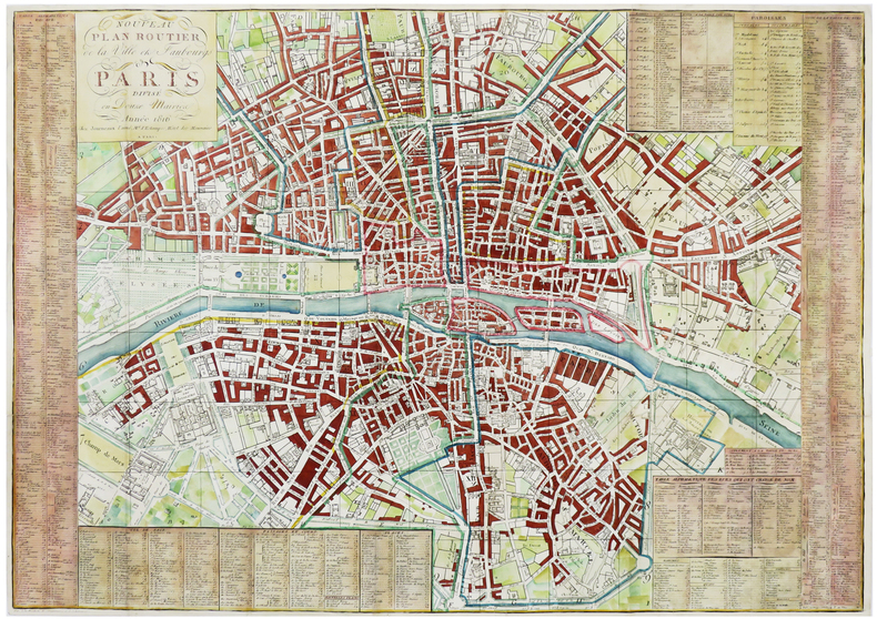
JOURNEAUX.
Nouveau plan routier de la ville et faubourgs de Paris divisé en douze mairies.
Paris, Journeaux l'aîné, 1809. 543 x 764 mm.
Bookseller reference : LBW-3429
|
|
|
JOURNEAUX.
Nouveau plan routier de la ville et faubourgs de Paris divisé en douze mairies.
Paris, Journeaux l'aîné, 1816. 546 x 768 mm.
Bookseller reference : LBW-6179
|
|
|
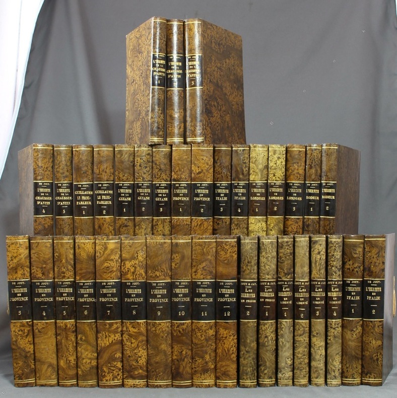
JOUY Etienne de; JAY Antoine; VILLEMAREST Charles-Maxime Catherinet de; LOUET DE CHAUMONT; SKINNER SURR Th.:
Observations sur les moeurs et les usages parisiens [français / des Italiens / des Anglais] au commencement du XIXe siècle. L'hermite de la Chaussée d'Antin I à V - Guillaume le franc-parleur, suite de L'hermite de la Chaussée d'Antin I & II - L'hermite de la Guiane I à III - L'hermite en province I à XII - Les hermites en prison I & II - Les hermites en liberté I à IV - L'hermite en Italie I à IV - L'hermite à Londres I à III - L'hermite rôdeur I & II.
A Paris / A Londres / Bruxelles, chez Pillet / chez Ladvocat / chez Martin Bossange / Aug. Wahlen / Malepeyre, 1813 à 1827. 37 volumes in-12, cartonnage imitation veau marbré, dos lisses ornés de filets, titre et tomaison dorés, pièces de titre noires, tranches mouchetées. Nom de possesseur à la plume à certains volumes, quelques rousseurs.
Bookseller reference : 12496
|
|
|
JOUR, Jean.
Scènes de la rue et Petits Metiers Parisiens en cartes postales anciennes.
Petit In-4, 143 pages, reliure editeur cartonnagee illustree. Bon etat. [QU-2]
|
|
|
Journal Maps Lovers; Paper Pen2
Modern Map of South Africa Journal: Take Notes Write Down Memories in this 150 Page Lined Journal
CreateSpace Independent Publishing Platform. Paperback. New. CreateSpace Independent Publishing Platform paperback
Bookseller reference : RG-HB-4306 ISBN : 1975892577 9781975892579
|
|
|
JOURNAL DES CHEMINS DE FER
Atlas des chemins de fer Fran?ais et ?trangers. Comprenant les cartes suivantes: l'Europe - de Paris ? Lyon - la M?dit?rann?e - d'orl?ans et du midi - de l'Est et des Ardennes - du Nord et de la Belgique - de l'Ouest - des environs de paris - de l'Espagne et du Portugal - de l'Italie et de la Suisse.
Broch?. 9 planches. A l'Italienne. 34 x 25 cm.
|
|
|
Jr. Vincent Wilson; Illustrator Maps by; Peter Guilday
The Book of the American Presidents with Portraits by Distinguished American Artists
American History Research Associates 1977. Paperback. Very Good. No marks no inscriptions. American History Research Associates paperback
Bookseller reference : 01553
|
|
|
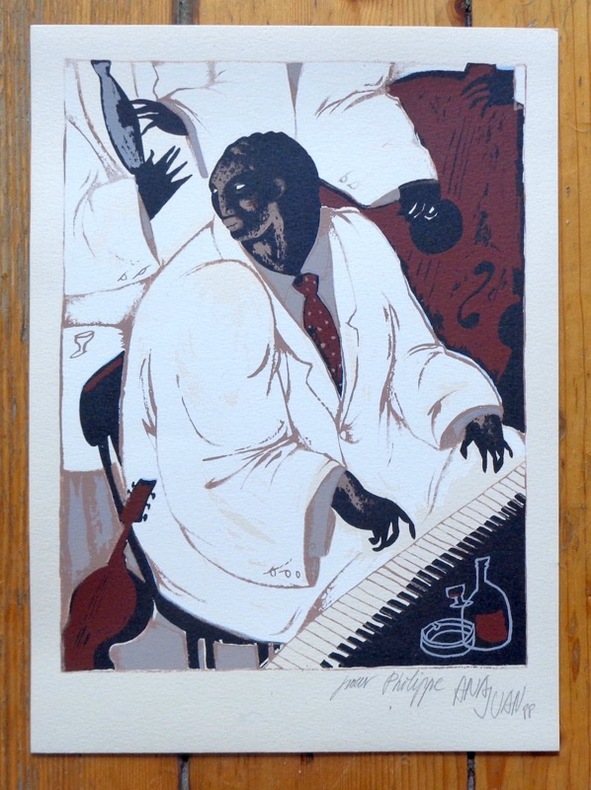
Juan Ana:
[Pianiste] - Sérigraphie dédicacée.
Lausanne, La Marge, 1988. Sérigraphie originale au format 18,5 x 25,5 cm.
Bookseller reference : 6318
|
|
|
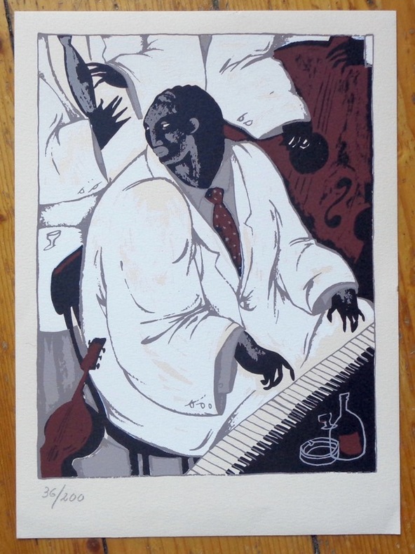
Juan Ana:
[Pianiste] - Sérigraphie numérotée.
Lausanne, La Marge, 1988. Sérigraphie originale au format 18,5 x 25,5 cm.
Bookseller reference : 8463
|
|
|
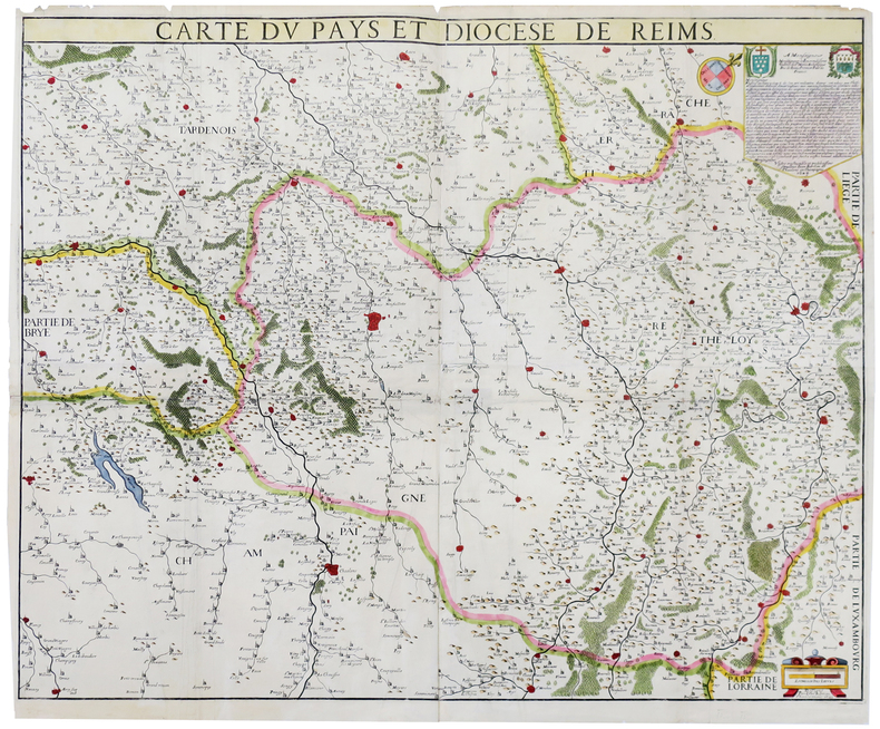
JUBRIEN (Jean).
[REIMS] Carte du pays et diocèse de Reims.
1623. En quatre feuilles jointes formant une carte de 672 x 834 mm.
Bookseller reference : LBW-6393
|
|
|
Jude TALBOT (sous la direction de)
FABULEUSES CARTES à JOUER
Un ouvrage de 248 pages, format 205 x 290 mm, illustré, relié cartonnage couleurs, publié en 2018, Gallimard / BNF Editions, bon état
Bookseller reference : LFA-126738584
|
|
|
Jules VERNE.
Claudius Bombarnac
Jules VERNE. Claudius Bombarnac. 55 illustrations par L. Benett, 6 grandes gravures en chromotypographie, 2 cartes en couleurs. 1892, Bibliothèque d'éducation et de récréation J. Hetzel et Cie, "Les voyages extraordinaires", Paris. 1 vol. grand in-8 relié de 285 pages. Cartonnage éditeur polychrome dit "au steamer", au macaron doré. Toutes tranches dorées. Gravures de Léon Benett. Bel exemplaire, très bon état, intérieur frais. Bon
Bookseller reference : 000258
|
|
|
Jules VERNE
Le tour du monde en quatre-vingt jours.
Jules VERNE. Le tour du monde en quatre-vingt jours. Illustré de dessins par De Neuville et L. Benett, 3 chromophototypies (illustrations en couleurs), et 1 cartes à double page. 1895, Bibliothèque d'éducation et de récréation J. Hetzel et Cie, "Les voyages extraordinaires", Paris. 1 vol. grand in-8 relié de 217 pages. Cartonnage éditeur polychrome dit "au steamer", au macaron rouge. Toutes tranches dorées. Gravures de Léon Benett. Très bon état, bel exemplaire, intérieur frais. Bon
Bookseller reference : 000256
|
|
|
JUNIÉ (Jean) & WUHRER (Louis).
[PAROISSES] Plan des paroisses de Paris avec la distinction des parties éparses qui en dépendent, dressé par ordre d'Illustrissime et Révérendissime Seigneur Monseigneur A.E.L. Le Clerc de Juigné, archevêque de Paris, duc de S.t Cloud, Pair de France. Par J. Junié, Ingén.r, Géog.e de Monseigneur l'Archevêque et Géomètre des Eaux et Forêts de France, reçu à la Maîtrise de Paris. M.DCC.LXXXVI.
1786-1904. En 8 sections montées sur toile de couleur bleu-gris et repliées, formant une carte de 1,24 x 1,89 m ; étiquette de papier vert au dos portant le titre.
Bookseller reference : LBW-8250

|
|
|
Jupp, Ursula
Home Port Victoria
Dust jacket worn around edges with tiny tears. Signed by author on the title page. 168 pages. "A collection of true stories of men and ships that sailed from this port, told by old seamen at meetings of the Thermopylae Club, Victoria, B.C,. including short sketches of their narrators, articles on relevant history of the Port of Victoria, and two maps."

|
|
|
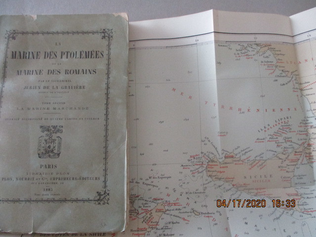
JURIEN de LA GRAVIERE ( Jean- Edmond Jurien de La Gravière, Brest, 1812, Paris, 1892), Vice-amiral, directeur des cartes et des plans au Ministère de la Marine. Membre de l'Académie des Sciences et de l'Académie française.
La Marine des Ptolémées et la Marine des Romains - Sommaire: Le Commerce de l'Orient - Le Commerce de la Mer Noire
1885 Paris, E. Plon, Nourrit et Cie, 1885 - T. II seul - Edition Originale - In-12, 120 x 180 mm - Broché, couverture légèrement sali - Ouvrage accompagné de deux cartes dépliantes en couleur. - 214 pages - bon exemplaire
Bookseller reference : 47039
|
|
|
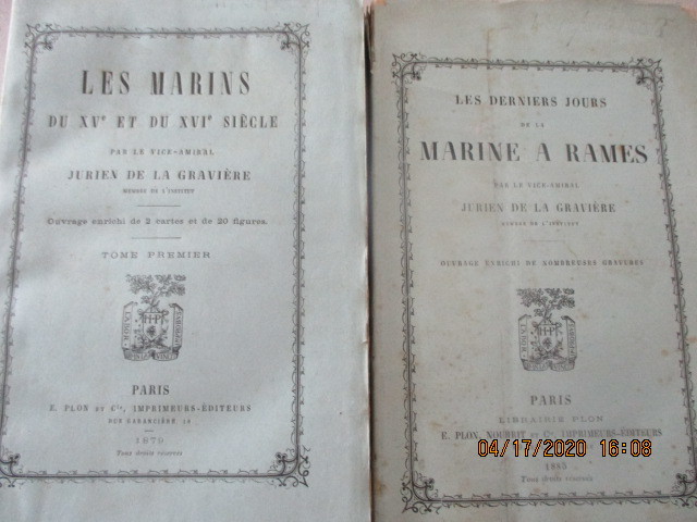
JURIEN de LA GRAVIERE ( Jean- Edmond Jurien de La Gravière, Brest, 1812, Paris, 1892), Vice-amiral, directeur des cartes et des plans au Ministère de la Marine. Membre de l'Académie des Sciences et de l'Académie française.
Les derniers jours de la marine à rames, de Jurien de La Graviere
1885 PARIS, Plon - 1885 - Edition Originale - In-12, 120 x 180 mm - Broché - nombreuses gravures P.P. - 252 pages - Exemplaire propre, non coupé, très frais
Bookseller reference : 47038

|
|
|
JURIEN de LA GRAVIERE ( Jean- Edmond Jurien de La Gravière, Brest, 1812, Paris, 1892), Vice-amiral, directeur des cartes et des plans au Ministère de la Marine. Membre de l'Académie des Sciences et de l'Académie française.
Marine - Les Derniers jours de la marine à rames.Sommaire : Chiourmes - Galères et galéasses - Naves et galions - Galère en cape - Construction d'une galère - Manoeuvres - etc.- Les Marins du XV è et du XV è siècle. Sommaire : Les origines de la Navigation moderne -La Mappemonde de Sébastien Cabot - 2 ouvrages
1847 Paris, E. Plon & Nourrit, 1885 - Edition originale - Brochée - in-12, 19 x 12 cm - 2 ff. n.fol. et 252 pp. agrémentée de planches hors-texte - Ex. non coupé - petit accroc en tête, bon exemplaire Paris, E. Plon & Nourrit, 1879 - T. I seul, Edition originale - Brochée - in-12, 19 x 12 cm - 2 ff. n.fol. et 321 pp. agrémentée de planches hors-texte - 1 grande carte dépliante représentant le monde d'après les idées de Sébastien Cabot en 1544 - bon exemplaire
Bookseller reference : 46905
|
|
|
JURA
Carte d?partementale couleurs au 1/200 000?me. Sans date.
Une feuille repli?e. 55x72 cm.
|
|
|
JURA
Carte d?partementale en couleurs au 1/200 000e. D?but XXe.
Une feuille repli?e. 55x72 cm.
|
|
|
Justin VINCENT, Agent-Voyer
CARTE ROUTIERE KILOMÉTRIQUE DE LA LOIRE-INFÉRIEURE, avec indication des principales pentes, dressée par Justin VINCENT, Agent-Voyer
1900 carte dépliante grise entoilée in-octavo (21,5 x 9,5 cm), format déplié : 47,5 centimètres de large par 43 centimètres de haut, carte imprimée en rouge et noir, ornée de publicité d'entreprises nantaises en marge, ex-libris manuscrit à l'encre brune : H. CHAPRON Boulanger - Le Pellerin - Loire-Inférieure, sans date (1900 environ) Nantes Jules Péquignot Editeur,
Bookseller reference : 26376
|
|
|
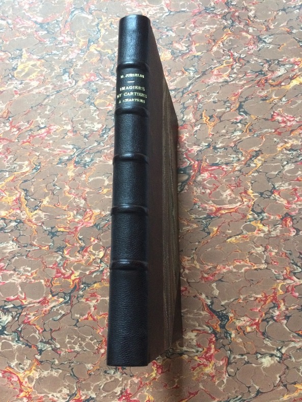
JUSSELIN Maurice Archiviste honoraire d'Eure et Loir
IMAGIERS & CARTIERS à CHARTRES
1957 Paris, librairie d'Argences 1957. Bibliothèque elzévirienne, nouvelle série Etudes et documents. In 8° relié en demi-chagrin à coins, dos à 5 nerfs, nom d'auteur et titre dorés sur le dos. 283pp et 30 planches hors-texte, avec la liste des productions connues de l'imagerie populire chartraine par Adolphe AYNAUD. Exemplaire en parfait état dans une reliure de qualité, couverture et dos conservés.
Bookseller reference : 2190
|
|
|
JUSTEL (Henri)
Recueil de divers voyages faits en Afrique et en l'Amérique qui n'ont point esté encore publiez, contenant l'origine, les mœurs, les coutumes & le commerce des habitans de ces deux parties du monde.
Paris, Louis Billaine, 1674. in-4 (228x164) , relié plein basane (19eme), épidermures, manque aux dos, coiffes arasées, premier plat et titre détachés, petite réparation au pli de la carte des Barbades, intérieur frais, illustré de 12 planches hors texte et trois cartes dépliantes (Barbades , Jamaïque et Virginie, Maryland et la Nouvelle-Angleterre) manque la carte du Nil.
Bookseller reference : PHO-1756

|
|
|
Juutilainen Ilmari/Nikunen Heikki trans/Gillcrist Paul trans/Ojanpera Marjukka layout/maps
Double Fighter Knight
Tampere: Apali/Uusi Kivipaino Oy printed by 1996. 1st printing. VG/no dust jacket. 255 p. photos maps index 8vo laminated boards; Apali/Uusi Kivipaino Oy (printed by) hardcover
Bookseller reference : 66683 ISBN : 9525026043 9789525026047

|
|
|
JÉRÔME (J.).
[INDOCHINE] Annam, Cochinchine et Tong-Kinn.
Paris, Librairie Garnier F.res, [1885]. 426 x 303 mm.
Bookseller reference : LBW-6751

|
|
|
KAEPPELIN P.
Géographie cours supérieur, nouvelle édition,certificat d’études A.LEYRITZ
In 4 demi-toile rouge,titre et mappemonde sur le premier plat,faux-titre,carte de France muette,titre,95 pages,2 feuillets exercices géographiques, texte sur 2 colonnes, cartes en couleurs,illustrations photographiques.A Hatier éditeur sans date,tache légère,sans gravité au deuxième plat,sinon Très bon exemplaire.
Bookseller reference : 4721
|
|
|
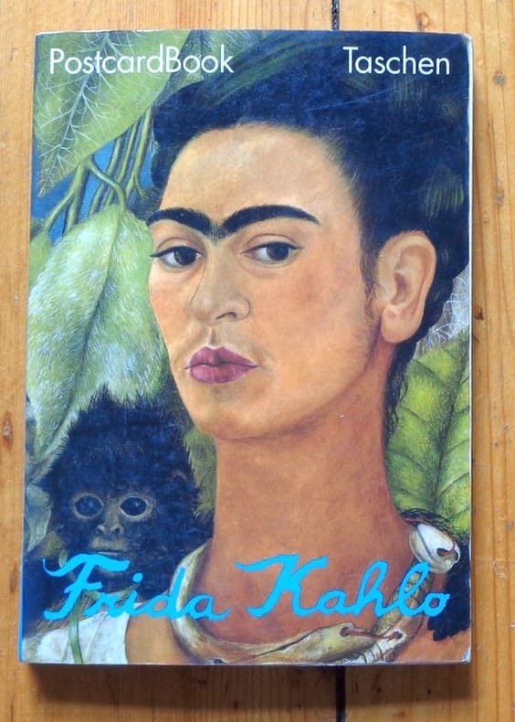
Kahlo Frida, Martin Isabel (prés.):
Postcard book - Frida Kahlo.
Taschen, 1992. In-12, cartonnage illustré. Texte introductif agrémenté de photographies en noir, suivi des 30 cartes postales avec des reproductions de l'artiste, détachables (la dernière est d'ailleurs détachée). Infimes frottements.
Bookseller reference : 5649
|
|
|
kalender,
Kalender - calender 2013, Brussel, Bruxelles, trafic.
, Plaizier, 2013-2013 kalender 2013 met 12 foto's van Brussel. 30x30cm spiraalband aan bovenzijde.
Bookseller reference : 38191
|
|
|
Kalman Tibor:
T.BOR A Book (to keep) +30 Postcards (to send).
New York, Little Bookroom, 2000. In-8 à l'italienne, couverture imprimée (un peu salie, la partie détachable du second plat a été. . . détachée - hélas).
Bookseller reference : 10499

|
|
|
Kalcovsky, Antonin (art editor)
Praha
No marks or inscriptions. No creasing to covers or to spine. A very clean very tight copy with bright unmarked white cloth boards and no bumping to corners. Dust jacket not price clipped or marked or torn or creased. 192pp. Architectural and cultural pictorial guide to Prague. Interestingly the Mayor states (in 1985) that the city was saved in 1945 by the illustrious (!) Soviet Army from destruction.. A number of poems in Czech throughout the book. The page-referenced index at the end names each illustration in five languages including English.

|
|
|
kalender
Kalender - calender 2013, Brussel, Bruxelles, trafic.
kalender 2013 met 12 foto's van Brussel. 30x30cm spiraalband aan bovenzijde. 12 fraaie foto's van Brussel in kalendervorm, periode 1900-2012

|
|
|
Kalischer, Peter; Hodge, Carle; Froman, Robert; Meany, Tom; Maher, Sergeant Marty; Campion Nardi Reeder; Smith, H. Allen; Wodehouse, P.G.; Et al
Collier's Magazine, September 6, 1952 - The Koje Snafu / Zsa Zsa Gabor Cover
70 pages. Features: Nice color-photo portrait of distinguished builder Mr. Henry Doelger in Lord Calvert ad inside front cover; Bell Telephone one-page ad features photo and write-up of Denis Hartnett who was "Mr. Telephone" to the people of Homer, NY; Color photos of a Lion Luncheon in Kenya; Nostalgic 1-page 2-color ad for USS (US Steel) shows where their products were used; Vintage Goodyear 1-page color photo ad promotes their new Lifeguard Safety Tubes; The Koje Snafu - major article with color photos explains how U.S. Brigadier General Francis Townsend Dodd was seized by his captives and another was lured into signing Red propaganda - the astonishing inside story from the Korean War; What You Don't Know About Your Eyes; Article on Salt - 14,000 uses and $0.02/pound; Gabbing with the Gabors - article with great bedroom photos of Zsa Zsa, Magda, Mama and Eva; The Windfall (fiction); Pigs Have Wings (fiction); Baseball's Biggest Bargain - article on the Brooklyn Dodgers with fantastic color photos of many team members including Jackie Robinson; Blood Money (fiction); Ninety Saddles for Kengtu (fiction); Brief article and two color photos of native artist Frank White Eagle; First or Nothing (fiction); History Hinges on These Two Rivers - excelllent color photos of US troops near the Yalu River and US naval vessels in the Rhine - with brief article; Ike is My Boy - West Point's salty Old Sarge, Sergeant Marty Maher, reveals Ike's sports loves - article with four photos of Ike; Inch and a Half to Go - humor about women and maps; Camel cigarette ad on back cover features opera star Patrice Munsel. Couple of chips from top of back cover. Average wear. Library stamp on front cover and back page. A worthy vintage copy. Book

|
|
|
Kampen, Alb. van
Orbis Terrarum Antiquus. In Scholarum Usum Descriptus. Editio altera. Insunt Tabulae XVI cum XXX Tabellis.
Gotha, Haack, (1964). 4°. 1 Bl. 16 Seiten mit farbigen Karten. Orig.-Halbleinenband., 15649bb Einbanddeckel mit leichten Gebrauchsspuren.
Bookseller reference : 15649BB

|
|
|
KANE, Elisha Kent:
Arctic explorations: the second Grinnell Expedition In Search of Sir John Franklin, 1853, '54, '55.
Philadelphia, Childs & Peterson, 1857. 2 volumes in-8 de 2-464-2 et 2-467-2, pages, pleine percaline bleue, dos (un peu passés) avec titre doré et roulettes à froid, plats ornés d'un navire dans un décor à froid. Quelques rousseurs, nom de possesseur sur gardes.
Bookseller reference : 9560

|
|
 Receive by email
 Download as PDF document
 RSS feed


