|
Collins Maps
Collins Greater London Street Atlas
Collins 06/20/2013. New edition. Paperback. Used; Good. WE SHIP WITHIN 24 HRS FROM LONDON UK 98% OF OUR ORDERS ARE RECEIVED WITHIN 7-10 DAYS. We believe you will be completely satisfied with our quick and reliable service. All orders are dispatched as swiftly as possible! Buy with confidence! Collins paperback
Bookseller reference : 2407851 ISBN : 0007494467 9780007494460

|
|
|
Collins Maps
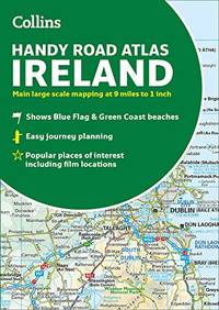
Collins Handy Road Atlas Ireland
Collins 2016-06-01. Paperback. Good. No CD Included. Access code may be previously used. Moderate dirt wear wrinkling or creasing on cover or spine. Good binding. Moderate writing and highlighting. Cover has used book stickers or residue. Marker on cover or bottom edge of book. Collins paperback
Bookseller reference : 0008158649-3 ISBN : 0008158649 9780008158644

|
|
|
Collins Maps
Collins Handy Road Atlas Ireland
Paperback / softback. New. Explore Ireland with this handy format route-planning atlas in full colour complete with information on places of tourist interest. There are also fully indexed town centre plans of Belfast Cork Dublin Galway Limerick and Londonderry. Now includes famous film locations. paperback
Bookseller reference : A9780008320393 ISBN : 000832039x 9780008320393
|
|
|
Collins Maps
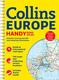
Collins Handy Road Atlas Europe
Harpercollins Publishers 2017. Spiral Bound. New. 5th revised ed edition. 180 pages. Harpercollins Publishers unknown
Bookseller reference : __0008214182 ISBN : 0008214182 9780008214180

|
|
|
Collins Maps
Collins Handy Road Atlas Scotland Collins Road Atlas
Collins 2018. Paperback. New. new edition edition. 72 pages. 8.25x5.75 inches. Collins paperback
Bookseller reference : __0008276390 ISBN : 0008276390 9780008276393

|
|
|
Collins Maps
Collins Handy Road Atlas Ireland
Collins 2019. Paperback. New. new edition edition. 64 pages. 8.15x5.79x0.30 inches. Collins paperback
Bookseller reference : __000832039X ISBN : 000832039X 9780008320393

|
|
|
Collins Maps
Collins Handy Map Ireland
Harpercollins Publishers 2020. Sheet Map Flat. New. 464 pages. Harpercollins Publishers unknown
Bookseller reference : __0008369984 ISBN : 0008369984 9780008369989

|
|
|
Collins Maps
Collins Handy Map Ireland Maps
Collins 2017. Map. New. new edition edition. 9.29x5.43x0.31 inches. Collins unknown
Bookseller reference : 2-0008183740 ISBN : 0008183740 9780008183745

|
|
|
Collins Maps
Collins Handy Road Atlas Ireland
Collins 03/10/2016. New edition. Paperback. Used; Good. WE SHIP WITHIN 24 HRS FROM LONDON UK 98% OF OUR ORDERS ARE RECEIVED WITHIN 7-10 DAYS. We believe you will be completely satisfied with our quick and reliable service. All orders are dispatched as swiftly as possible! Buy with confidence! Collins paperback
Bookseller reference : 3752080 ISBN : 0008158649 9780008158644
|
|
|
Collins Maps
Collins Handy Road Atlas Ireland
HarperCollins Publishers Limited 2016. Paperback. Good. Disclaimer:A copy that has been read but remains in clean condition. All pages are intact and the cover is intact. The spine may show signs of wear. Pages can include limited notes and highlighting and the copy can include previous owner inscriptions. At ThriftBooks our motto is: Read More Spend Less.Dust jacket quality is not guaranteed. HarperCollins Publishers Limited paperback
Bookseller reference : G0008158649I3N00 ISBN : 0008158649 9780008158644

|
|
|
Collins Maps
Collins Handy Road Atlas Scotland
Paperback. New. This easy-to-use handy A5 sized road atlas is your ideal companion for navigating around Scotland. It has extremely clear route planning maps of Scotland detailed city plans of the major cities and towns and fits neatly into your glove box or briefcase or bag. MAIN FEATURES Clear attractive rout paperback
Bookseller reference : ria9780008276393_new ISBN : 0008276390 9780008276393
|
|
|
Collins Maps
Collins Handy Road Atlas Europe
Spiral bound. New. Handy A5 format road atlas of Europe with lie-flat spiral binding. Ideal format for both drivers and those travelling by public transport. Scenic routes are plotted on the maps. Scale: 1:2000000 Main features of this atlas: Handy A5 format road atlas of Europe at 34 miles to 1inch. Euroroutes and unknown
Bookseller reference : ria9780008214180_new ISBN : 0008214182 9780008214180
|
|
|
Collins Maps
Collins Handy Map Ireland
Sheet map. New. Easy-to-use route-planning map covering the whole of Ireland opens almost like a book. It has the convenience of an atlas with all the benefits of a fold out map and features clear full-colour road maps at 10 miles to 1 inch plus city centre plans of Belfast and Dublin. The map is laminated on bot unknown
Bookseller reference : ria9780008183745_new ISBN : 0008183740 9780008183745
|
|
|
Collins Maps
Collins Handy Road Atlas Ireland
Paperback. New. Explore Ireland with this handy format route-planning atlas in full colour complete with information on places of tourist interest. There are also fully indexed town centre plans of Belfast Cork Dublin Galway Limerick and Londonderry. This atlas at A5 size contains mapping of the whole of Ire paperback
Bookseller reference : ria9780008320393_new ISBN : 000832039X 9780008320393
|
|
|
Collins Maps
Collins Handy Road Atlas Ireland
2019-05-01. New. Ships with Tracking Number! INTERNATIONAL WORLDWIDE Shipping available. May be re-issue. Buy with confidence excellent customer service! unknown
Bookseller reference : 000832039Xn ISBN : 000832039x 9780008320393

|
|
|
Collins Maps
Collins Handy Road Atlas Ireland
2019-05-01. Good. Ships with Tracking Number! INTERNATIONAL WORLDWIDE Shipping available. May not contain Access Codes or Supplements. May be re-issue. May be ex-library. Shipping & Handling by region. Buy with confidence excellent customer service! unknown
Bookseller reference : 000832039X ISBN : 000832039x 9780008320393

|
|
|
Collins Maps
Collins Handy Road Atlas Ireland
Paperback. As New. Explore Ireland with this handy format route-planning atlas in full colour complete with information on places of tourist interest. There are also fully indexed town centre plans of Belfast Cork Dublin Galway Limerick and Londonderry. This atlas at A5 size contains mapping of the whole of Ire paperback
Bookseller reference : ria9780008320393_rkm ISBN : 000832039X 9780008320393
|
|
|
Collins Maps
Collins Handy Road Atlas Ireland
HarperCollins UK. Used - Like New. Ships from the UK. Book in almost Brand New condition. 100% Money Back Guarantee. Your purchase also supports literacy charities. HarperCollins UK unknown
Bookseller reference : GRP105731888 ISBN : 0008158649 9780008158644
|
|
|
Collins Maps
Collins Handy Road Atlas Europe
Spiral bound. New. Handy A5 format road atlas of Europe with lie-flat spiral binding. Ideal format for both drivers and those travelling by public transport. Scenic routes are plotted on the maps. Scale: 1:2000000 unknown
Bookseller reference : A9780008214180 ISBN : 0008214182 9780008214180
|
|
|
Collins Maps
Collins Handy Road Atlas Ireland
2016-02-02. Good. Ships with Tracking Number! INTERNATIONAL WORLDWIDE Shipping available. May not contain Access Codes or Supplements. May be re-issue. May be ex-library. Shipping & Handling by region. Buy with confidence excellent customer service! unknown
Bookseller reference : 0008158649q ISBN : 0008158649 9780008158644

|
|
|
Collins Maps
Collins Handy Road Atlas Scotland
Paperback. As New. This easy-to-use handy A5 sized road atlas is your ideal companion for navigating around Scotland. It has extremely clear route planning maps of Scotland detailed city plans of the major cities and towns and fits neatly into your glove box or briefcase or bag. MAIN FEATURES Clear attractive rout paperback
Bookseller reference : ria9780008276393_rkm ISBN : 0008276390 9780008276393
|
|
|
Collins Maps
Collins Handy Road Atlas Scotland
2015-06-03. New. Ships with Tracking Number! INTERNATIONAL WORLDWIDE Shipping available. May be re-issue. Buy with confidence excellent customer service! unknown
Bookseller reference : 0008126321n ISBN : 0008126321 9780008126322

|
|
|
Collins Maps
Collins Handy Street Map London
2016-09-09. New. Ships with Tracking Number! INTERNATIONAL WORLDWIDE Shipping available. May be re-issue. Buy with confidence excellent customer service! unknown
Bookseller reference : 0008136645n ISBN : 0008136645 9780008136642

|
|
|
Collins Maps
Collins Handy Road Atlas Ireland
2016-02-02. New. Ships with Tracking Number! INTERNATIONAL WORLDWIDE Shipping available. May be re-issue. Buy with confidence excellent customer service! unknown
Bookseller reference : 0008158649n ISBN : 0008158649 9780008158644

|
|
|
Collins Maps
Collins Handy Map Ireland
2017-03-02. New. Ships with Tracking Number! INTERNATIONAL WORLDWIDE Shipping available. May be re-issue. Buy with confidence excellent customer service! unknown
Bookseller reference : 0008183740n ISBN : 0008183740 9780008183745

|
|
|
Collins Maps
Collins Handy Map Ireland
2017-03-02. Good. Ships with Tracking Number! INTERNATIONAL WORLDWIDE Shipping available. May not contain Access Codes or Supplements. May be re-issue. May be ex-library. Shipping & Handling by region. Buy with confidence excellent customer service! unknown
Bookseller reference : 0008183740 ISBN : 0008183740 9780008183745

|
|
|
Collins Maps
Collins Handy Road Atlas Europe International Road Atlases
Collins. Fourth edition. Spiral-bound. Used; Good. Simply Brit Shipped with Premium postal service within 24 hours from the UK with impressive delivery time. We have dispatched from our book depository; items of good condition to over ten million satisfied customers worldwide. We are committed to providing you with reliable and efficient service at all times. 07/03/2014 Collins unknown
Bookseller reference : 2113746 ISBN : 0007581165 9780007581160

|
|
|
Collins Maps
Collins Handy Street Map London
2016-09-09. Good. Ships with Tracking Number! INTERNATIONAL WORLDWIDE Shipping available. May not contain Access Codes or Supplements. May be re-issue. May be ex-library. Shipping & Handling by region. Buy with confidence excellent customer service! unknown
Bookseller reference : 0008136645 ISBN : 0008136645 9780008136642

|
|
|
Collins Maps
Collins Handy Street Map London Collins Travel Guides
Collins. New edition. Map. Used; Good. Simply Brit Shipped with Premium postal service within 24 hours from the UK with impressive delivery time. We have dispatched from our book depository; items of good condition to over ten million satisfied customers worldwide. We are committed to providing you with reliable and efficient service at all times. 05/09/2013 Collins unknown
Bookseller reference : 1597086 ISBN : 0007493134 9780007493135

|
|
|
Collins Maps
Collins Handy Map Ireland
Sheet map. As New. Easy-to-use route-planning map covering the whole of Ireland opens almost like a book. It has the convenience of an atlas with all the benefits of a fold out map and features clear full-colour road maps at 10 miles to 1 inch plus city centre plans of Belfast and Dublin. The map is laminated on bot unknown
Bookseller reference : ria9780008183745_rkm ISBN : 0008183740 9780008183745
|
|
|
Collins Maps
Collins Ireland Handy Road Atlas International Road Atlases
2013-08-08. New. Ships with Tracking Number! INTERNATIONAL WORLDWIDE Shipping available. May be re-issue. Buy with confidence excellent customer service! unknown
Bookseller reference : 0007490526n ISBN : 0007490526 9780007490523

|
|
|
Collins Maps
Collins Ireland Comprehensive Road Atlas
HarperCollins UK 2015-05-01. Spiral-bound. Very Good. HarperCollins UK unknown
Bookseller reference : 0008102287-2-18497076 ISBN : 0008102287 9780008102289

|
|
|
Collins Maps
Collins Ireland Touring Map Maps
Collins 2017. Map. New. new edition edition. 9.29x5.67x0.71 inches. Collins unknown
Bookseller reference : __0008183732 ISBN : 0008183732 9780008183738

|
|
|
Collins Maps
Collins Ireland Road Atlas
Paperback. New. Road atlas at A4 size covering the whole of Ireland featuring clear and detailed Collins colour mapping at a scale of 5.2 miles to 1 inch. Perfect for both residents and visitors touring Ireland. Clear detailed and up-to-date Collins mapping showing: Places of tourist interest Contact informa paperback
Bookseller reference : ria9780008183721_new ISBN : 0008183724 9780008183721

|
|
|
Collins Maps
Collins Ireland Touring Map
Sheet map. New. Large full colour Collins map of the whole of Ireland showing the road network in detail and with a special emphasis on places of tourist interest. This map has a handy touring scale of 7.5 miles to 1 inch 1:475200. It has over 20 categories of tourist information depicted on the map with clear unknown
Bookseller reference : ria9780008183738_new ISBN : 0008183732 9780008183738
|
|
|
Collins Maps
Collins Ireland Handy Road Atlas International Road Atlases
HarperCollins UK. Used - Good. Ships from the UK. Former Library book. Shows some signs of wear and may have some markings on the inside. 100% Money Back Guarantee. Your purchase also supports literacy charities. HarperCollins UK unknown
Bookseller reference : GRP106524345 ISBN : 0007490526 9780007490523

|
|
|
Collins Maps
Collins Ireland Touring Map
Sheet map folded. New. Large full colour Collins map of the whole of Ireland showing the road network in detail and with a special emphasis on places of tourist interest. unknown
Bookseller reference : A9780008183738 ISBN : 0008183732 9780008183738

|
|
|
Collins Maps
Collins Ireland Road Atlas: Touring edition
Paperback / softback. New. Road atlas at A4 size covering the whole of Ireland featuring clear and detailed Collins colour mapping at a scale of 5.2 miles to 1 inch. Perfect for both residents and visitors touring Ireland. paperback
Bookseller reference : A9780008183721 ISBN : 0008183724 9780008183721

|
|
|
Collins Maps
Collins Ireland Handy Road Atlas International Road Atlases
2013-08-08. Good. Ships with Tracking Number! INTERNATIONAL WORLDWIDE Shipping available. May not contain Access Codes or Supplements. May be re-issue. May be ex-library. Shipping & Handling by region. Buy with confidence excellent customer service! unknown
Bookseller reference : 0007490526 ISBN : 0007490526 9780007490523

|
|
|
Collins Maps
Collins Ireland Comprehensive Road Atlas
2015-05-05. New. Ships with Tracking Number! INTERNATIONAL WORLDWIDE Shipping available. May be re-issue. Buy with confidence excellent customer service! unknown
Bookseller reference : 0008102287n ISBN : 0008102287 9780008102289

|
|
|
Collins Maps
Collins Ireland Touring Map
Sheet map. As New. Large full colour Collins map of the whole of Ireland showing the road network in detail and with a special emphasis on places of tourist interest. This map has a handy touring scale of 7.5 miles to 1 inch 1:475200. It has over 20 categories of tourist information depicted on the map with clear unknown
Bookseller reference : ria9780008183738_rkm ISBN : 0008183732 9780008183738
|
|
|
Collins Maps
Collins Ireland Road Atlas
Paperback. As New. Road atlas at A4 size covering the whole of Ireland featuring clear and detailed Collins colour mapping at a scale of 5.2 miles to 1 inch. Perfect for both residents and visitors touring Ireland. Clear detailed and up-to-date Collins mapping showing: Places of tourist interest Contact informa paperback
Bookseller reference : ria9780008183721_rkm ISBN : 0008183724 9780008183721
|
|
|
Collins Maps
Collins Junior Atlas Collins Primary Atlases
Paperback / softback. New. Fully revised and updated for 2020 this is an ideal world reference atlas for young primary school geographers aged 9-11 years Key stage 2. Published in association with the Geographical Association it enables children to learn about the world today and understand how maps and atlases work. paperback
Bookseller reference : A9780008381516 ISBN : 0008381518 9780008381516

|
|
|
Collins Maps
Collins Junior Atlas Collins Primary Atlases
Collins 2020. Paperback. New. fifth edition edition. 80 pages. 12.25x9.00 inches. Collins paperback
Bookseller reference : __0008381518 ISBN : 0008381518 9780008381516

|
|
|
Collins Maps
Collins Junior World Atlas
HarperCollins UK. Used - Good. Former Library book. Shows some signs of wear and may have some markings on the inside. HarperCollins UK unknown
Bookseller reference : GRP95762482 ISBN : 0007393571 9780007393572

|
|
|
Collins Maps
Collins London Essential Street Finder Collins Travel Guides
2010-07-01. New. Ships with Tracking Number! INTERNATIONAL WORLDWIDE Shipping available. May be re-issue. Buy with confidence excellent customer service! unknown
Bookseller reference : 0007317883n ISBN : 0007317883 9780007317882

|
|
|
Collins Maps
Collins London Handy Street Map
Sheet map folded. New. Clear and easy-to-read map of central London and surrounding area. Contains detailed mapping presented in a handy compact format. This attractive map ideal for both tourists and residents and fully updated has an extensive area of coverage and displays a wealth of detail. unknown
Bookseller reference : A9780008320584 ISBN : 0008320586 9780008320584

|
|
|
Collins Maps
Collins London Handy Street Map
Collins 2019. Map. New. new edition edition. Collins unknown
Bookseller reference : __0008320586 ISBN : 0008320586 9780008320584

|
|
|
Collins Maps
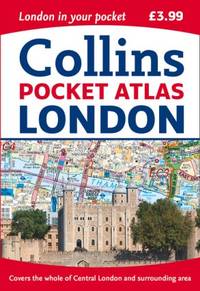
Collins London Pocket Atlas
Collins. Used - Very Good. Good shape with typical wear. Pages are unmarked and sharp. Paperback Used - Very Good Ships fast! 2015New edition Collins paperback
Bookseller reference : ND-121863 ISBN : 0008104573 9780008104573
|
|
|
Collins Maps
Collins London Pocket Atlas
Collins. New edition. Paperback. Used; Acceptable. Box damaged but books are in good condition. Simply Brit Shipped with Premium postal service within 24 hours from the UK with impressive delivery time. We have dispatched from our book depository; items of good condition to over ten million satisfied customers worldwide. We are committed to providing you with reliable and efficient service at all times. 02/02/2012 Collins paperback
Bookseller reference : 2939225 ISBN : 0007452454 9780007452453

|
|
 Receive by email
 Download as PDF document
 RSS feed


