|
Cramm, Geo. F.
1889 Color Map of China, With Inset Map of Japan
Outside dimensions 10.75" x 14.5". Unmarked with light wear and soiling. An attractive vintage copy. Book

|
|
|
Cramm, Geo. F.
1889 Color Map of Egypt, Arabia, Upper Nubia and Abyssinia
Outside dimensions 14.5" x 10.75". Unmarked with light wear and soiling. An attractive vintage copy. Book

|
|
|
Cramm, Geo. F.
1889 Color Map of Europe
Outside dimensions 10.75" x 14.5". Unmarked with light wear and soiling. An attractive vintage copy. Book

|
|
|
Cramm, Geo. F.
1889 Color Map of France
Outside dimensions 10.75" x 14.5". Local districts individually colored. Unmarked with light wear and soiling. An attractive vintage copy. Book

|
|
|
Cramm, Geo. F.
1889 Color Map of India
Outside dimensions 14.5" x 10.75". Unmarked with light wear and soiling. An attractive vintage copy. Book

|
|
|
Cramm, Geo. F.
1889 Color Map of Ireland
Outside dimensions 14.5" x 10.75". Counties individually coloured. Unmarked with light wear and soiling. An attractive vintage copy. Book

|
|
|
Cramm, Geo. F.
1889 Color Map of Italy
Outside dimensions 14.5" x 10.75". Regions individually colored. Unmarked with light wear and soiling. An attractive vintage copy. Book

|
|
|
Cramm, Geo. F.
1889 Color Map of Japan (Nihon)
Outside dimensions 14.5" x 10.75". Unmarked with light wear and soiling. An attractive vintage copy. Book

|
|
|
Cramm, Geo. F.
1889 Color Map of Palestine
Outside dimensions 14.5" x 10.75". Unmarked with light wear and soiling. 4" archival tape mend to lower right corner. An attractive vintage copy. Book

|
|
|
Cramm, Geo. F.
1889 Color Map of San Francisco, California (CA)
Outside dimensions 14.5" x 10.75". Includes many street names, prominent buildings, hotels, churches, theatres, steam roads, cable and horse roads. Unmarked with light wear and soiling. An attractive vintage copy. Book

|
|
|
Cramm, Geo. F.
1889 Color Map of Sweden and Norway
Outside dimensions 14.5" x 10.75". Unmarked with light wear and soiling. An attractive vintage copy. Book

|
|
|
Cramm, Geo. F.
1889 Color Map of the City of Minneapolis, Minnesota (MN)
Outside dimensions 14.5" x 10.75". Includes many street names. Steam and horse railroads indicated. Unmarked with light wear and soiling. An attractive vintage copy. Book

|
|
|
Cramm, Geo. F.
1889 Color Map of the City of New Orleans, Louisiana (LA)
Outside dimensions 14.5" x 10.75". Steam and horse roads indicated. Includes many street names plus lists of prominent buildings and hotels. Unmarked with light wear and soiling. An attractive vintage copy. Book

|
|
|
Cramm, Geo. F.
1889 Color Map of the City of Omaha, Nebraska (NE)
Outside dimensions 14.5" x 10.75". Includes many street names. Unmarked with light wear and soiling. An attractive vintage copy. Book

|
|
|
Cramm, Geo. F.
1889 Color Map of the City of St. Louis, Missouri (MO)
Outside dimensions 14.5" x 10.75". Steam and horse roads indicated. Includes many street names plus lists of prominent buildings, hotels, depots and theatres. Unmarked with light wear and soiling. An attractive vintage copy. Book

|
|
|
Cramm, Geo. F.
1889 Color Map of the East Indies
Outside dimensions 10.75" x 14.5". Unmarked with light wear and soiling. An attractive vintage copy. Book

|
|
|
Cramm, Geo. F.
1889 Color Map of The Turkish Empire in Europe and Asia, Greece, Roumania, Etc.
Outside dimensions 10.75" x 14.5". Unmarked with light wear and soiling. An attractive vintage copy. Book

|
|
|
Cramm, Geo. F.
1889 Color Map Showing the Territorial Growth of the United States 1776-1887
Outside dimensions 10.75" x 14.5". Unmarked with light wear and soiling. An attractive vintage copy. Book

|
|
|
Crampton C. Gregory and Steven K. Madsen design by Warren Archer maps drawn by Don Bufkin
IN SEARCH OF THE SPANISH TRAIL: SANTA FE TO LOS ANGELES 1829-1848
Salt Lake City: Gibbs-Smith Publisher Peregrine Smith Book 1994. Near Fine. 1994. First Edition. Trade Paperback. 0879056142 . First edition. "The first study to locate and map the historic Spanish Trail". Oversize about 8.5" x 11" 144 pages illustrated with photographs drawings and maps bibliography map bibliography index. Near Fine copy shallow lower corner crimping to some pages. . Gibbs-Smith Publisher [Peregrine Smith Book] [1994] paperback
書籍販売業者の参照番号
: 66276 ISBN : 0879056142 9780879056148

|
|
|
Cranny, Michael W.; Garrod, Stan; McGuire, Margit; Birchell, Gary
Pacific Rim Discovery - Student Resource
96 pages. Gazetteer. Maps and abundant colour illustrations and photos throughout. Bit of liquid paper atop front free endpaper otherwise clean and unmarked with moderate wear. Binding tight. A quality copy. Book

|
|
|
CREPY (Etienne-Louis).
Carte nouvelle des environs de Paris contenant aussy la Brie.
Paris, Crépy, 1753. En 16 sections montées sur toile et pliées, formant une carte de 503 x 718 mm.
書籍販売業者の参照番号
: LBW-747
|
|
|
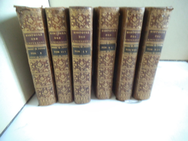
CREVIER
Histoire des empereurs romains
depuis Auguste jusqu’à Constantin.6 volumes en 6 tomes sur 12.Tomes 1,3,4,6,8,12,in 12 plein veau glacé fauve,pièce de titre chagrin rouge et pièce de tomaison chagrin vert, fars,roulette,palmette dorés.roulette dorée sur coupes. Tome :faux-titre,titre,XVIII,2 cartes dépliantes La Palestine par le Sieur d’Anville 1750.Germanie et les pays situés entre le Danube et la mer Adriatique par le sieur d’Anville 1749.529 pages,22 pages de table.Tome 3:titre, carte dépliante La Grande Bretagne par le sieur d’Anville Mars 1750 480 pages,14 pages de table.Tome 4:titre,518 pages,18 pages de table et approbation. Tome 6:titre,II,539 pages,20 pages de table et fautes à corriger. Mouillure, longitudinale en fin de volume, et en tête en début de volume. Tome VIII titre,I,494 pages,18 pages de table et fautes à corriger. Tome XII titre,600 pages pâle mouillure en tête. Desaint & Saillant 1749-1755.
書籍販売業者の参照番号
: 6560
|
|
|
Crestin-Billet Frédérique
La Folie des cartes à jouer
Flammarion 2002 In-18 broché 14 cm sur 14. 377 pages. Très bon état d’occasion.
書籍販売業者の参照番号
: 98198
|
|
|
Created by PopOut Maps
Berlin PopOut Map
Sheet map. New. Explore the vibrant city of Berlin with the help of this genuinely pocket-sized pop-up map. Small in size yet big on detail this compact dependable Berlin city map will ensure you don't miss a thing. Includes two pop-up maps covering Berlin Charlottenburg & Mitte Additional maps covering unknown
書籍販売業者の参照番号
: ria9781910218464_new ISBN : 1910218464 9781910218464
|
|
|
Created by PopOut Maps
Berlin PopOut Map
Sheet map. As New. Explore the vibrant city of Berlin with the help of this genuinely pocket-sized pop-up map. Small in size yet big on detail this compact dependable Berlin city map will ensure you don't miss a thing. Includes two pop-up maps covering Berlin Charlottenburg & Mitte Additional maps covering unknown
書籍販売業者の参照番号
: ria9781910218464_rkm ISBN : 1910218464 9781910218464
|
|
|
Created by PopOut Maps
Manchester PopOut Map
Hardback. New. Discover energetic Manchester with the help of this genuinely pocket-sized pop-up map. Small in size yet big on detail this compact dependable Manchester city map will ensure you don't miss a thing. Includes a PopOut map - a detailed street map of the city centre as well as Salford Quays and m hardcover
書籍販売業者の参照番号
: ria9781910218617_new ISBN : 1910218618 9781910218617
|
|
|
Created by PopOut Maps
Manchester PopOut Map
Hardback. As New. Discover energetic Manchester with the help of this genuinely pocket-sized pop-up map. Small in size yet big on detail this compact dependable Manchester city map will ensure you don't miss a thing. Includes a PopOut map - a detailed street map of the city centre as well as Salford Quays and m hardcover
書籍販売業者の参照番号
: ria9781910218617_rkm ISBN : 1910218618 9781910218617
|
|
|
Created by PopOut Maps
Prague PopOut Map
Paperback. New. Discover the Czech capital of Prague in all its historic beauty with the help of this genuinely pocket-sized pop-up map. Small in size yet big on detail this compact dependable Prague city map will ensure you don't miss a thing. Includes 2 PopOut maps - a detailed street map of Prague city centr paperback
書籍販売業者の参照番号
: ria9781910218815_new ISBN : 1910218812 9781910218815
|
|
|
Created by PopOut Maps
Prague PopOut Map
Paperback. As New. Discover the Czech capital of Prague in all its historic beauty with the help of this genuinely pocket-sized pop-up map. Small in size yet big on detail this compact dependable Prague city map will ensure you don't miss a thing. Includes 2 PopOut maps - a detailed street map of Prague city centr paperback
書籍販売業者の参照番号
: ria9781910218815_rkm ISBN : 1910218812 9781910218815
|
|
|
Created by International Travel Maps
South Korea / Seoul 2017
Sheet map. New. unknown
書籍販売業者の参照番号
: ria9781553412762_new ISBN : 1553412761 9781553412762
|
|
|
Created by International Travel Maps
South Korea / Seoul 2017
Sheet map. As New. unknown
書籍販売業者の参照番号
: ria9781553412762_rkm ISBN : 1553412761 9781553412762
|
|
|
Creator Compass Maps
Insideout New Orleans City Guide Insideout City Guide: New Orleans
Map Group Inc 2005-04-09. Paperback. Good. Map Group Inc paperback
書籍販売業者の参照番号
: SONG184587000X ISBN : 184587000X 9781845870003

|
|
|
Creator Compass Maps
Insideout Hong Kong City Guide Insideout City Guide: Hong Kong
Map Group Inc 2006-02-28. Hardcover. Good. Map Group Inc hardcover
書籍販売業者の参照番号
: SONG1904766722 ISBN : 1904766722 9781904766728

|
|
|
Creator Compass Maps
Insideout San Francisco City Guide San Francisco Insideout City Guide
Map Group Inc 2006-02-09. Hardcover. Good. Map Group Inc hardcover
書籍販売業者の参照番号
: SONG1904766641 ISBN : 1904766641 9781904766643

|
|
|
Creator Ltd. Compass Maps
Berlin Insideout City Guide Insideout City Guide: Berlin
Very Good. Used book in very good condition. Some cover wear may contain a few marks. 100% guaranteed. 060220 unknown
書籍販売業者の参照番号
: 1904766005[vg] ISBN : 1904766005 9781904766001

|
|
|
Creator Ltd. Compass Maps
Insideout Berlin City Guide Insideout City Guide: Berlin
Map Group Inc 2003-12. Paperback. Good. Map Group Inc paperback
書籍販売業者の参照番号
: SONG1904766005 ISBN : 1904766005 9781904766001
|
|
|
Creator Streetwise Maps
Streetwise Orlando
Streetwise Maps 2001-07-01. Map. Good. Streetwise Maps unknown
書籍販売業者の参照番号
: SONG1886705402 ISBN : 1886705402 9781886705401

|
|
|
Creator Time Traveler Maps
The Colorado Plateau: Map & Guide to Public Lands on the Colorado Plateau & its Borderlands
Time Traveler Maps 2004-06. Map. Good. Time Traveler Maps unknown
書籍販売業者の参照番号
: SONG1892040166 ISBN : 1892040166 9781892040169
|
|
|
Creighton, John
Cheshire: A Portrait in Words and Pictures
Neat inscription to front end paper. No other marks or inscriptions. Very minor creasing to lower corner of front cover, none to rear or to spine. A very clean very tight copy with bright unmarked boards, a trace of sunning to lower front edge and no bumping to corners. 156pp. A guide to Cheshire, its history, its places to visit and its industry and industrial heritage. Well illustrated.

|
|
|
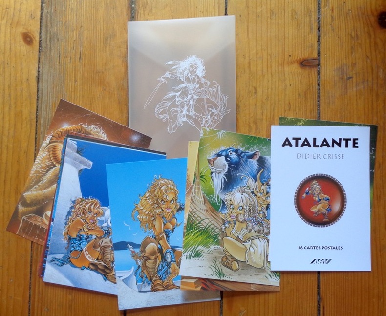
CRISSE Didier
Atalante - 16 cartes postales
16 cartes postales sous pochette translucide (Ref.: ref95693)
書籍販売業者の参照番号
: 9782845222488
|
|
|
Crisse Didier:
Atalante. 16 cartes postales.
PMJ éditions Port-folio translucide, bien complet des 16 cartes postales annoncées au feuillet de titre. A l'état de neuf.
書籍販売業者の参照番号
: 911
|
|
|
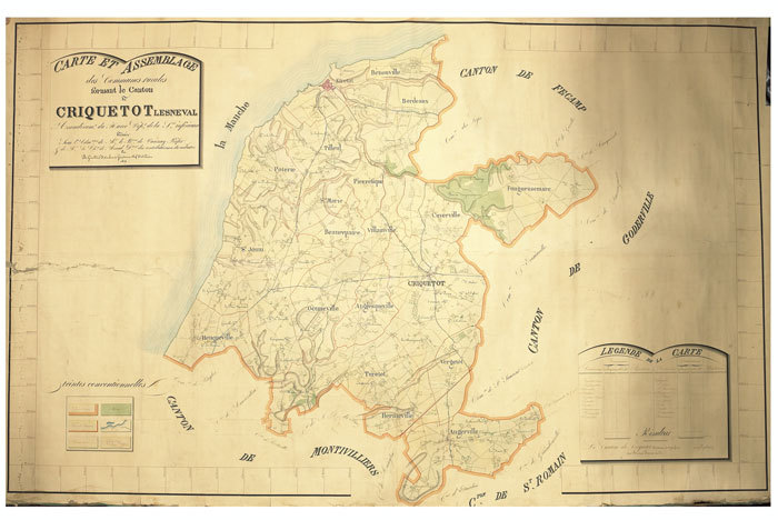
CRIQUETOT-l'ESNEVAL. MANUSCRIT.
Carte et assemblage des communes rurales formant le canton de Criquetot Lesneval, arrondissement du Havre, département de la Seine-Inférieure. Dressée sous l’administration de M. Le Bon de Vanssay, préfet, & de M. Le Cher de Merval, directeur des contributions du cadastre, par B. Girard et F. Carbonnie, géomètres en chef du cadastre.
1827. 1275 x 2000 mm.
書籍販売業者の参照番号
: LBW-660
|
|
|
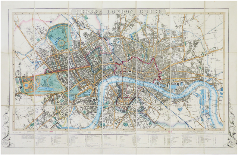
CROSS (Joseph).
[LONDRES] Cross's London guide.
London, J. Cross, [circa 1842-1843]. En 21 sections montées sur toile et pliées, formant un plan de 477 x 740 mm ; plats de papier bleu au dos, protégeant le plan une fois replié.
書籍販売業者の参照番号
: LBW-7239
|
|
|
CROZAT. -
Abrégé de la Géographie de Crozat, par demandes et par réponses, (...); précédé d'un Traité de la Sphère. Adopté pour les Ecoles secondaires. Nouvelle édition, revue, corrigée et augmentée d'une table alphabétique des villes; avec cartes géographiques. A l'usage des jeunes gens.
Lille, Leleux, 1812, in-8°, 2 ff. + IV + 243 p., avec 2 cartes gravées dépliantespar Robert de Vaugondy (Europe et la France), papier quelque peu bruni, cartonnage en papier peint moucheté.
書籍販売業者の参照番号
: 29076aaf
|
|
|
CROZAL
Pour bien jouer et gagner aux cartes.
Paris, sans mention d'éditeur, sans date, 12 X 15 cm., agrafé, 45 pp. La manille, le piquet, le bésigue, l'écarté, le whist, le bridge, le poker, le rams, le trente-et-un, la banque, le nain jaune. Couverture illustrée en couleurs avec pli et déchirure, et partiellement dégrafée. Intérieur propre. Rare.
書籍販売業者の参照番号
: 2234

|
|
|
Crofton, Ian
Walking the Border : A Journey Between Scotland and England
Book and jacket appear in as new unread condition. 246pp. A complete walk along the Border from Gretna to Lamberton, just north of Berwick on Tweed, filled with information on nature, literature, history and the people who lived there.

|
|
|
Crookston, Peter (editor)
Village England
No inscriptions or marks. A lovely clean crisp very tight copy with bright unmarked boards and no bumping to corners. Dust jacket not price clipped or torn or creased. 256pp. Taken from the highly successful Observer Magazine series, Village England is a catalogue of all that is best in England. Twenty-four towns were chosen as centres to explore, and their surrounding villages are detailed with places to visit, things to do, national parks, model railways, places to eat and drink etc. With over 170 colour photographs, it is an introduction to the true England: quiet, picturesque, calm and beautiful.

|
|
|
Crosher, G.R.
Along the Chiltern Ways
Ex-library copy with usual (minimal) marks and stamps. A very clean very tight copy with bright unmarked boards, upper corner of front end paper clipped and no bumping to corners. Dust jacket not price clipped or marked or torn with minor traces of handling. 178pp. A study of the areas around the Icknield Ways, the two ancient green lanes that run from Goring on the Thames to beyond Royston at the edge of East Anglia.

|
|
|
Cross Robin/Dew Stephen maps
Fallen Eagle: The Last Days of the Third Reich
London: Caxton Editions 2000. reprint. Fine/Fine dust jacket. xii 292 p. photos maps appendices biblio index 8vo glossy illus boards; Caxton Editions hardcover
書籍販売業者の参照番号
: 23280 ISBN : 1840671548 9781840671544

|
|
|
CRUYL Lievin (Ghendt 1640 - 1720)
Pianta di Roma come si trova al presente colle alzate delle fabbriche piu nobili cosi antiche come moderne
La pianta del Cruyl, pubblicata per la prima volta nel 1665 dalla tipografia De Rossi, è una delle rare immagini della città che presenta contemporaneamente sia un impianto iconografico che prospettico.Le vedute presenti in questa pianta sono le stesse che furono poi oggetto di specifiche vedute intagliate dall’artista fiammingo, quasi come una sorta di catalogo personale.L’esemplare in questione è edito da Giovanni Battista De Rossi nel 1665. Sono note una ristampa con l'aggiunta di alcune vedute dei luoghi notabili ad opera di Matteo Gregorio de Rossi (1696) e un’ulteriore tiratura a cura di Carlo Losi, datata 1773.Incisa da Giulio Testone, su due matrici di rame, tracce di pieghe di carta, alcune abrasioni, nel complesso in ottimo stato di conservazione.In alto al centro il titolo: PIANTA DI ROMA COME SI TROVA AL PRESENTE COLLE ALZATE DELLE FABRICHE PIU NOBILI COSI ANTICHE COME MODERNE. Nel bordo superiore del riquadro: a sinistra L. Cruyl delin., al centro Superiorum licen. a destra Giulio Testone Romano Sculp.Opera molto rara e ricercata. Magnifico esemplare della tiratura di Carlo Losi, in perfetto stato di conservazione.BibliografiaArrigoni-Bertarelli (1939): n. 142; Christie’s (1998): p. 50, n. 1043; Ehrle (1908): p. 23; Frutaz (1962): pp. 216-217, n. CLIV, Tav. 343; Hülsen (1915): XXIV, pp. 87-89, nn. 110-111; Jatta (1992): p. 166, n. 31s; Jatta (2012); Marigliani (2007): pp. 216-217, n. 124 e p. 249, n. 155; Roma Veduta (2000): p. 175, n. 31; Scaccia Scarafoni (1939): pp. 125-126, n. 241. Etching with engraving, 1665. A fine impression, with plate tone, of the third state of three, printed on 2 sheets of contemporary laid paper, full margins, very good condition.This map was published for the first time in 1665 by De Rossi; it is one of the rare images of the city depicting, at the same time, an iconographic and perspective system. The views are the same that the Flemish artist engraved afterwards as a sort of personal catalogue. The first state has been printed by Giovanni Battista De Rossi in 1665. The plate was then published by Matteo Gregorio de Rossi in 1696 and finally reissued by Carlo Losi, in 1773. It has been engraved by Giulio Testone on two copper plates.A very rare and important map of Rome. A great example. Literature Arrigoni-Bertarelli (1939): n. 142; Christie’s (1998): p. 50, n. 1043; Ehrle (1908): p. 23; Frutaz (1962): pp. 216-217, n. CLIV, Tav. 343; Hülsen (1915): XXIV, pp. 87-89, nn. 110-111; Jatta (1992): p. 166, n. 31s; Jatta (2012); Marigliani (2007): pp. 216-217, n. 124 e p. 249, n. 155; Roma Veduta (2000): p. 175, n. 31; Scaccia Scarafoni (1939): pp. 125-126, n. 241.

|
|
 検索結果のメールを受信する
 PDFファイルの検索結果をダウンロード
 RSSフィード


