|
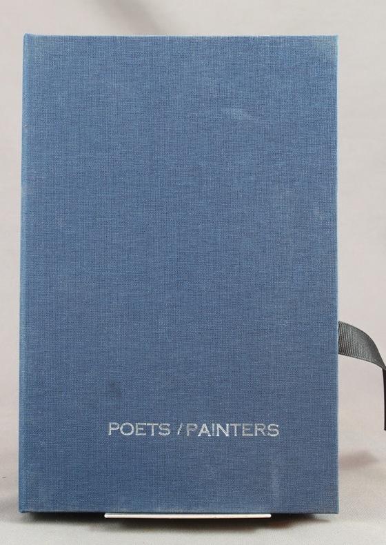
DAHI Soheyl (dir.):
Poets/Painters. 30 cards + 1.
San Fransisco, Sore Dove Press, 2008. 31 cartes en carton de 21,7 x 14 cm, dont une "carte de titre", imprimées en noir au verso, sous emboîtage de toile bleu nuit, titre argenté au premier plat, ruban noir pour extraire les cartes de l'emboîtage. Comme neuf.
Referentie van de boekhandelaar : 7673
|
|
|
DAHLBERG, ERIK.
Saalstad. W. Swidde Sculp.
Holmiæ (Stockholm), 1693. 21,5x41,5 cm. Kobberstukket prospekt med ridende og vognkørende folk i forgrunden. Fra Svecia Antiqva et Hodierna.
Referentie van de boekhandelaar : 28092
|
|
|
DAHLBERG, ERIK.
Giöksholm. J.v.d. Aveelen Sc.
Holmiæ (Stockholm), 1702. 22,5x36,5 cm. Kobberstukket prospekt fra Svecia Antiqva et Hodierna. Et par smårifter i marginer, intet tab.
|
|
|
DAHLBERG, ERIK.
Saalstad. W. Swidde Sculp.
Holmiæ (Stockholm), 1693. 21,5x41,5 cm. Kobberstukket prospekt med ridende og vognkørende folk i forgrunden. Fra Svecia Antiqva et Hodierna.
|
|
|
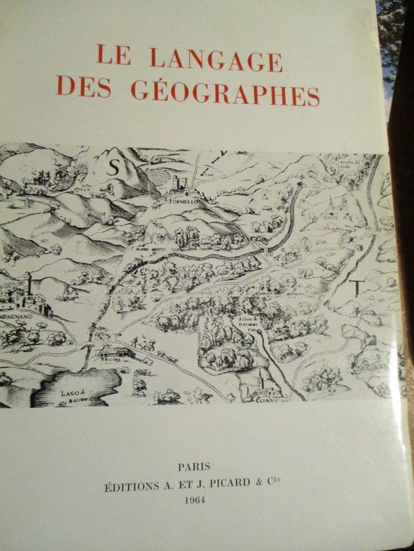
Dainville ( François de)
le langage des géographes
1964 Paris Picard et Cie 1964 In8 broché 384 pages 24 planches hors texte Index des termes très bon état
Referentie van de boekhandelaar : 5800
|
|
|
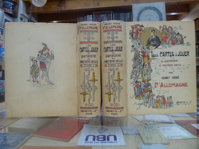
DALLEMAGNE Henry-René
LES CARTES À JOUER du Quatorzième au Vingtième Siècle.
Librairie Hachette & Cie Paris 1906 2 volumes grands et forts in-4 ( 325 X 265 mm ) de XVI-504 et 640 pages, cartonnage éditeur illustré en couleurs, tête dorée. 3200 reproductions de cartes dont 956 en couleurs, 12 planches hors-texte coloriées à l'aquarelle, 25 phototypies, 116 enveloppes illustrées pour jeux de cartes & 340 vignettes & vues diverses. Edition originale et premier tirage. Minimes défauts aux mors et aux coiffes, ( comme toujours ), sinon très bel exemplaire, bien complet de ses serpentes, condition rare.
Referentie van de boekhandelaar : 684269
|
|
|
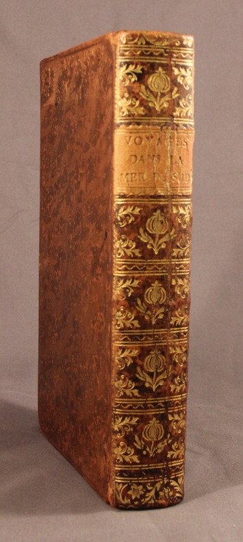
DALRYMPLE M.; FREVILLE M. de (trad.):
Voyages dans la mer du Sud, par les Espagnols et les Hollandois.
A Paris, Chez Saillant & Nyon; Pissot, 1774. In-8 de [4]-XIV-[2]-502-[2] pages, plein veau brun moucheté, dos lisse orné de fleurons et motifs dorés, étiquette de titre orange, plats encadrés d’un filet à froid, tranches rouges.
Referentie van de boekhandelaar : 2118
|
|
|
Dale Alzina Stone and maps by Kenneth Daly
Mystery Reader's Walking Guide : New York
Lincolnwood Il. Passport Books 1994. 8vo. cloth backed boards hardcover; 361 pages; maps by Kenneth Dale; from the dustjacket: "11 walks that folow the paths of the most widely read mystery writers their sleuths and characters;" a fine clean tight unmarked copy in a fine dustjacket. <br/><br/> Lincolnwood, Il. Passport Books 1994) hardcover
Referentie van de boekhandelaar : 26192

|
|
|
Dale Alzina Stone and Barbara Sloan Hendershott Dust Wrapper art and interior maps by John Babcock
MYSTERY READER'S WALKING GUIDE: LONDON
Lincolnwood: Passport Books 1987. Very Good in Very Good dust jacket. 1987. Book Club BCE/BOMC. Hardcover. Presumed Book Club edition no price on Dust Wrapper flap and small square blind punch to lower right corner of the rear board of the book. "11 fascinating walks that follow the paths of the most widely read mystery writers their sleuths and characters". 294 pages illustrated with maps including the endpapers bibliography index of persons places and books. Slight bowing to boards book slightly ajar else would be a Near Fine copy in VG/Near Fine Dust Wrapper with a few short edge tears. . Passport Books [1987] hardcover
Referentie van de boekhandelaar : 25975

|
|
|
Dalley, Sam (editor)
The Independent Hostel Guide 1995; UK and Ireland
No marks or inscriptions and no creasing to covers. A very clean very tight copy with bright unmarked boards and no bumping to corners. 96pp. The first in a series of guides for outdoor enthusiasts and budget travellers.

|
|
|
Dalrymple Byron; Maps by Delos D. Rowe Associates with basic maps courtesy ofRand McNally & Company
COMPLETE GUIDE TO HUNTING ACROSS NORTH AMERICA An Outdoor Life Book.
New York & London: Harper & Row Publishers. VG/G. 1970. . Cloth. Specially prepared maps keyed to the text pinpoint Game Management Areas Waterfowl Refuges State and National Forests State Parks and other public hunting grounds. Includes a listing of private hunting preserves. . 8vo. 848pp. Jacket rubbed & frayed at tips with small tears . Harper & Row, Publishers hardcover
Referentie van de boekhandelaar : BOOKS238950
|
|
|
Daly RN BA MEdHons BHScN PhD MACE AFACHSE FCN FRCNA John Speedy RN BAHons DipEd MURP EdN MAPS FANZCMHN Sandra
Contexts of Nursing 4e
Churchill Livingstone. Used - Good. Ships from the UK. Former Library book. Shows some signs of wear and may have some markings on the inside. 100% Money Back Guarantee. Your purchase also supports literacy charities. Churchill Livingstone unknown
Referentie van de boekhandelaar : GRP117720150 ISBN : 0729541525 9780729541527

|
|
|
Daly RN BA MEdHons BHScN PhD MACE AFACHSE FCN FRCNA John Speedy RN BAHons DipEd MURP EdD MAPS FANZCMHN Sandra
Contexts of Nursing
Churchill Livingstone Australia. Used - Good. Ships from UK in 48 hours or less usually same day. Your purchase helps support the African Children's Educational Trust A-CET. Ex-library so some stamps and wear but in good overall condition. 100% money back guarantee. We are a world class secondhand bookstore based in Hertfordshire United Kingdom and specialize in high quality textbooks across an enormous variety of subjects. We aim to provide a vast range of textbooks rare and collectible books at a great price. Through our work with A-CET we have helped give hundreds of young people in Africa the vital chance to get an education. We provide a 100% money back guarantee and are dedicated to providing our customers with the highest standards of service in the bookselling industry. Churchill Livingstone Australia unknown
Referentie van de boekhandelaar : Z1-C-013-01753 ISBN : 0729541525 9780729541527
|
|
|
Daly RN BA MEdHons BHScN PhD MACE AFACHSE FCN FRCNA John Speedy RN BAHons DipEd MURP EdD MAPS FANZCMHN Sandra
Contexts of Nursing: An Introduction 2e
Churchill Livingstone. Used - Good. Former Library book. Shows some signs of wear and may have some markings on the inside. Churchill Livingstone unknown
Referentie van de boekhandelaar : GRP102280390 ISBN : 0729537463 9780729537469

|
|
|
Daly RN BA MEdHons BHScN PhD MACE AFACHSE FCN FRCNA John Speedy RN BAHons DipEd MURP EdD MAPS FANZCMHN Sandra
Contexts of Nursing: An Introduction 2e
Churchill Livingstone. Used - Very Good. Former Library book. Great condition for a used book! Minimal wear. Churchill Livingstone unknown
Referentie van de boekhandelaar : GRP102280502 ISBN : 0729537463 9780729537469
|
|
|
Daly RN BA MEdHons BHScN PhD MACE AFACHSE FCN FRCNA John Speedy RN BAHons DipEd MURP EdD MAPS FANZCMHN Sandra
Contexts of Nursing 3e
Churchill Livingstone. Used - Very Good. Ships from the UK. Former Library book. Great condition for a used book! Minimal wear. 100% Money Back Guarantee. Your purchase also supports literacy charities. Churchill Livingstone unknown
Referentie van de boekhandelaar : GRP85506239 ISBN : 0729539253 9780729539258
|
|
|
Daly RN BA MEdHons BHScN PhD MACE AFACHSE FCN FRCNA John Speedy RN BAHons DipEd MURP EdN MAPS FANZCMHN Sandra
Leadership and Nursing: Contemporary perspectives 2e Year Books
Churchill Livingstone. Used - Very Good. Ships from the UK. Former Library book. Great condition for a used book! Minimal wear. 100% Money Back Guarantee. Your purchase also supports literacy charities. Churchill Livingstone unknown
Referentie van de boekhandelaar : GRP117861045 ISBN : 0729541533 9780729541534

|
|
|
Daly RN BA MEdHons BHScN PhD MACE AFACHSE FCN FRCNA John/ Speedy RN BAHons DipEd MURP EdN MAPS FANZCMHN Sandra/
Leadership and Nursing: Contemporary perspectives 2e Year Books
Churchill Livingstone 2014. Paperback. New. 2nd edition. 296 pages. 9.65x6.89x0.71 inches. Churchill Livingstone paperback
Referentie van de boekhandelaar : __0729541533 ISBN : 0729541533 9780729541534
|
|
|
Daly RN BA MEdHons BHScN PhD MACE AFACHSE FCN FRCNA John Speedy RN BAHons DipEd MURP EdN MAPS FANZCMHN Sandra
Leadership and Nursing: Contemporary perspectives 2e Year Books
Churchill Livingstone. Used - Good. Ships from the UK. Former Library book. Shows some signs of wear and may have some markings on the inside. 100% Money Back Guarantee. Your purchase also supports literacy charities. Churchill Livingstone unknown
Referentie van de boekhandelaar : GRP117245816 ISBN : 0729541533 9780729541534
|
|
|
Daly RN BA MEdHons BHScN PhD MACE AFACHSE FCN FRCNA John Speedy RN BAHons DipEd MURP EdN MAPS FANZCMHN Sandra
Leadership and Nursing: Contemporary perspectives 2e Year Books
Churchill Livingstone. Used - Good. Ships from Reno NV. Shows some signs of wear and may have some markings on the inside. 100% Money Back Guarantee. Shipped to over one million happy customers. Your purchase benefits world literacy! Churchill Livingstone unknown
Referentie van de boekhandelaar : GRP113762742 ISBN : 0729541533 9780729541534
|
|
|
Daly RN BA MEdHons BHScN PhD MACE AFACHSE FCN FRCNA John; Speedy RN BAHons DipEd MURP EdD MAPS FANZCMHN Sandra; Jackson RN Com
Leadership and Nursing: Contemporary perspectives 2e Year Books
Churchill Livingstone. PAPERBACK. 0729541533 Brand new book.Buy with confidence. Money Back Guarantee.Expedite Shipping Available. International shipment available. . New. Churchill Livingstone paperback
Referentie van de boekhandelaar : AABTP108031 ISBN : 0729541533 9780729541534
|
|
|
DANGER Fernand
"Cours de législation et économie rurales; livre 1 : Le bornage."
Paris, Editions Eyrolles, 1948. "16 x 24, 307 pp., broché, bon état (couverture défraîchie; cachets d'ex-propriétaire dont 1 sur la couverture)."
Referentie van de boekhandelaar : 91159
|
|
|
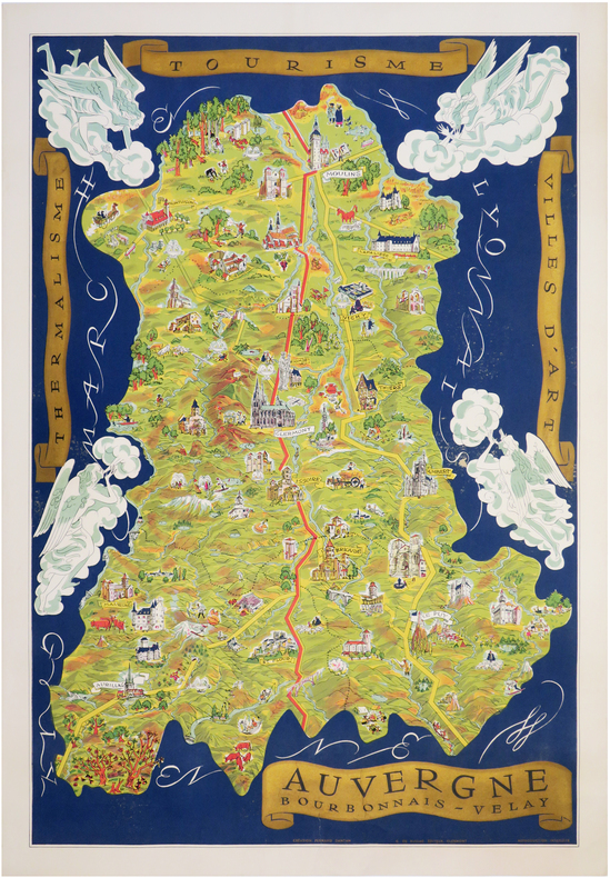
DANTAN (Fernand).
[AUVERGNE] Auvergne - Bourbonnais - Velay. Thermalisme - Tourisme - Villes d'art.
Clermont, G. de Bussac, [1950]. Lithographie en couleurs de 897 x 608 mm.
Referentie van de boekhandelaar : LBW-7141
|
|
|
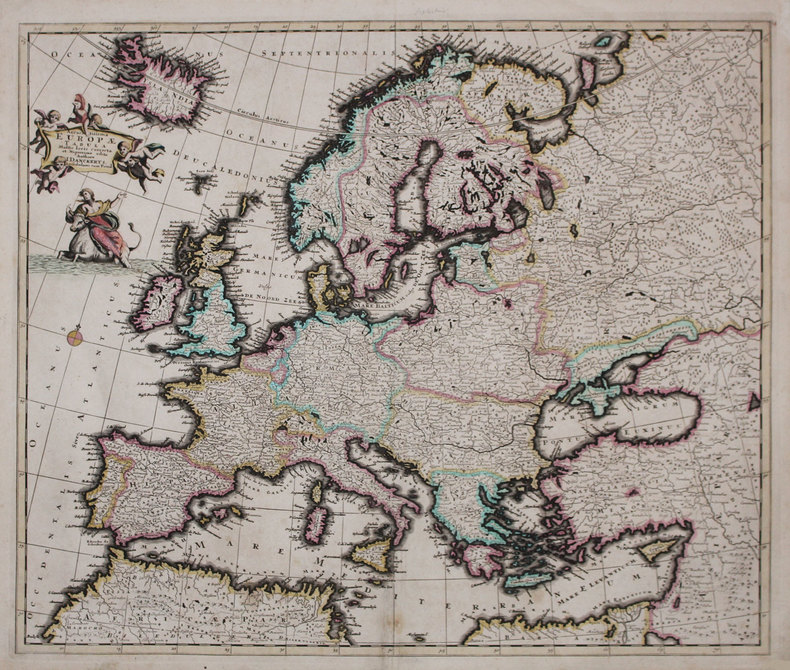
DANCKERTS (Justus).
Accuratissima Europæ tabula.
Amsterdam, [circa 1696]. 492 x 580 mm.
Referentie van de boekhandelaar : LBW-3222
|
|
|
DANMARKSKORT - DE L'ISLE, (GUIALLAUME).
Carte du Royaume de Danemarc.
Paris, chez Dezauche succ. De L'Isle et Buache, 1780. 49,5x65,5 cm. Kobberstukket kort over Danmark med Skåne, Halland og blekinge. Original konturkolorering. Brede marginer med mindre rifter.
Referentie van de boekhandelaar : 31052
|
|
|
DANMARKSKORT - DELISLE, GUILLAUME.
Carte du Royaume de Danemarc.
Amsterdam, Covens et Mortier, c. 1710-33. 49x60,5 cm. Kobberstukket Danmarkskort med Skåne, Halland og Blekinge. På svært papir og med original fuld håndkolorering. Frisk eksemplar.
Referentie van de boekhandelaar : 31679
|
|
|
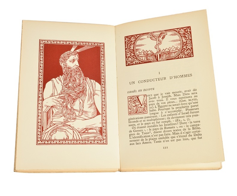
Daniel Rops (Henri Petiot, dit ; 1901-1965) :
Histoire Sainte. I Le Peuple de la Bible (2T) ; II Jésus en son temps (2T). Orné de bois gravé par Jean Lébedeff.
Librairie Fayard, 1946-1945 ; quatre tomes in-8 (228 mm), brochés, couvertures rempliées décorées ; 238; 329, [5 bl.] ; 410, [3 bl.], 1 carte dépliante ; 392, un plan dépliant ; frontispices, figures, lettrines, culs-de-lampe gravés sur bois et tirés en bistre.
Referentie van de boekhandelaar : 21612
|
|
|
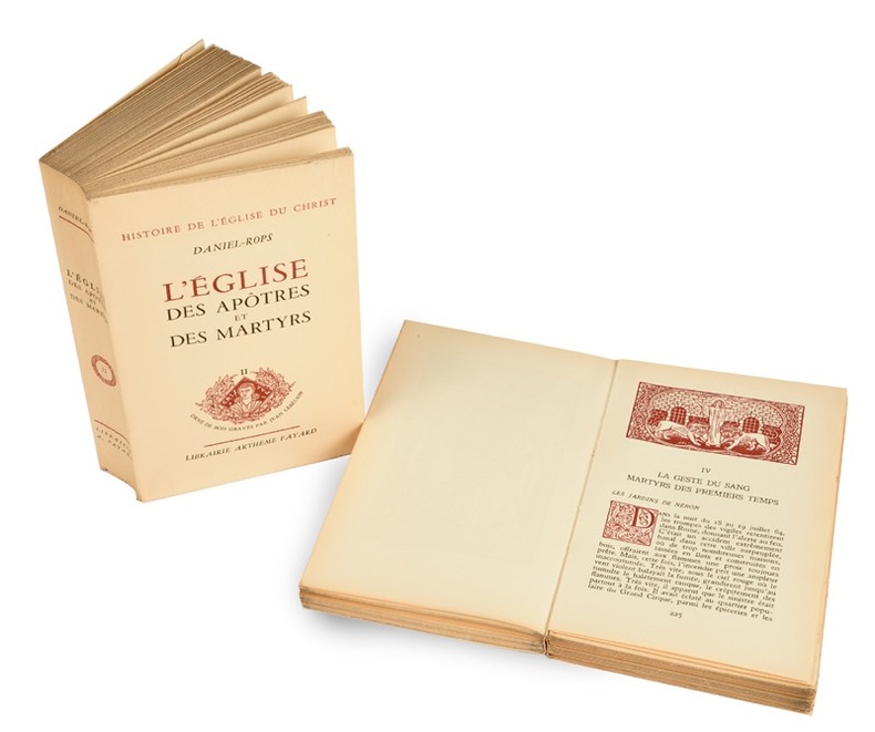
Daniel Rops (Henri Petiot, dit ; 1901-1965) :
Histoire de l’Eglise du Christ. L’Eglise des Apôtres et des Martyrs. Orné de bois gravés par Jean Lébedeff.
Librairie Arthème Fayard (imprimerie Coulouma), 1948; 2 tomes in-8 (228 mm), brochés, couverture crème rempliée et illustrée ; 491, [3 bl.]; 505, [5 bl.] pp.
Referentie van de boekhandelaar : 21613
|
|
|
Danielle LECOQ, Michel LEQUENNE et Frank LESTRINGANT
LA FABRIQUE DU MONDE : MAPPEMONDES et CARTES des DECOUVERTES
Un ouvrage de 62 pages, format 250 x 210 mm, illustré, broché couverture couleurs rempliée, publié en 1992, Société des Découvertes / Henri Berger Productions, bon état
Referentie van de boekhandelaar : LFA-126745191
|
|
|
DANTON.
Loi relative au rétablissement de la libre circulation des personnes & des choses dans l’Empire.
Bourg Imp. Philipon 1792 1 vol. Broché 1 bi-feuillet in-4 avec vignette gravée. Loi adoptée le 8 septembre 1792, au lendemain des massacres de septembre, sur proposition de Clavière et Danton, ministres respectivement des Finances et de la Justice.
Referentie van de boekhandelaar : 109516
|
|
|
DANMARKSKORT - J.B. HOMANN.
Regni Daniae in quo sunt Ducatus Holsatia et Slesvicum Insulae Danicae, Provinciae Iutia Scania Blekingia... Nova Tabula... Iohann Hübneri.
Nürnberg, (ca. 1740). Kobberstukket Danmarkskort med samtidig håndkolorereing, 49,5x59 cm. Visende også Skåne, Halland og Blekinge og i øverste højre hjørne stor kartouche med rigsvåbnet. Kortet er indrammet under glas i fin ramme af brun birkefiner.
Referentie van de boekhandelaar : 49793
|
|
|
DANMARKSKORT - TARCIEU, P.F.
Royaume de Danemarck. Deuxieme Carte. Dannemarck propre Le Jutland et les Isles.
(Paris, u.år ca 1800). 33,5 x 44 cm. Kobberstukket Danmarkskort, frisk velbevaret og konturkoloreret. Brede marginer. (P.F. Tardieu sculpsit - P.J. Valet scripsit).
Referentie van de boekhandelaar : 25256
|
|
|
Danckerts, Justus:
Novissima et accuratissima Helvetiae, Rhaetiae, Valesiae et Partis Sabaudiae Tabula. Ex officina Justi Danckerts
Format: 48,5 x 56,5 cm (bis zur äußeren Einfassungslinie beschnitten). *Generalkarte der Schweiz. Justus Danckerts (1635-1701) war Kupferstecher und Verleger in Amsterdam, Sohn des Kartenhändlers Cornelius Danckerts, er gründete um 1656 eine eigene Kartenoffizin. Gut erhalten. Landkarten de
|
|
|
Daniel H.; several maps Illustrator
ISLANDS OF THE PACIFIC L5
G. P. Putnam's Sons 1943-01-01. Hardcover. Very Good. SCARCE HARDCOVER BOOK IN DUST JACKET. NO WRITING OR MARKINGS IN TEXT. ALMOST NO WEAR TO COVER. SOME WEAR & FRAYING TO DUST JACKET. A CLEAN & SOLID BOOK. G. P. Putnam's Sons hardcover
Referentie van de boekhandelaar : B-1242
|
|
|
Danielow, Iwan.
Carte des europäisch- und eines Theils des asiatisch-russischen Reichs nach den neuesten astronomischen Ortsbestimmungen den grossen Atlas und andern Karten des russisch-Kaiserl. Karten-Depots verfasst, in Gouvernements eingetheilt, die Grentzen nach den letzten Friedenschlüssen berichtiget, dann die Post- und andere Hauptstrassen mit Bemerkung der Ortsentfernungen eingetragen. Carte de la partie européene et asiatique de l'Empire de Russie [...]. Vienna, T[ranquillo] Mollo, 1812.
Engraved map printed from 12 copper plates, with 2 supplements, dimensions 147,5 x 129 cm (including supplements 165 x 140 cm). Constant ratio linear horizontal scale ca. 1:2.1 million. Relief shown by hachures. Coordinates approximate and based on Greenwich meridian. Mounted on rough cloth; left and right edges protected by green strips of cloth. In French and German. Shows extensive detail of waterways, political divisions, various roads, post stations, variously sized settlements. Consisting of 12 main sheets and 2 supplements, the map "probably appeared just in time to be offered as a map of the theatre of Napoleon's invasion of Russia. Showing the area between Gdansk and Tobolsk, and between the Kara Strait and Armenia, the map displays (in the words of a contemporary review) 'most clearly, without being in any way cluttered, [...] all conceivably important settlements, mountains, rivers, lakes, etc. in the Russian Empire and its adjacent parts, and it is quite rightly to be preferred to all other renderings of the war theatre hitherto published, as it includes Astrakhan and Tobolsk, and is quite complete in every other respect, while other maps often include not even Moscow, for which reason this map is recommended as a very useful tool to anybody wishing to follow the history of the present war'" (cf. Dörflinger II, 463f.). The two supplements added at the middle of the lower and right edge concern the areas of Tobolsk and Tiflis. - Some occasional waterstaining; Tobolsk supplement fairly strongly wrinkled. The upper edge (beyond the plate) shows traces of former wall mounting. Dörflinger II, 463: Mol 39. Tooley I, 332 (without supplements). OCLC 964537090.

|
|
|
DANKERTS Justus (1635-1701)
Roma
Rara veduta prospettiva della città vista da Monte Mario. L'incisione è tratta dalla veduta incisa da Dominique Barriere nel 1649, rispetto alla quale risulta in controparte. "In alto, sopra il titolo, si vede lo stemma SPQR sormontato da una corona. IN basso a sinistra 12 righe di testo ed a destra una legenda di 42 numeri. Solo San Pietro è riconoscibile (neppure Castel Sant'Angelo lo è) da cui si deduce che la veduta è stata copiata e non realizzata dal vero; a conferma di questo la rappresentazione in controparte. Il prototipo da cui è tratta è la veduta incisa da Dominique Barriere nel 1649 con la quale peraltro coincidono anche i numeri e le voci di legenda. Già il De Jonghe aveva comunque realizzato nel 1665 una derivazione assai fedele del panorama del Barriere ed è probabile che a questa si sia rifatto il Dankerts" (cfr. Marigliani p. 211). Incisione su rame, in buono stato di conservazione.Non censita dai principali repertori. Rare perspective view of the city seen from Monte Mario. The panroama is taken from the view engraved by Dominique Barriere in 1649, to which it is in counterpart. At the top, above the title, we see the coat of arms SPQR surmounted by a crown. At the bottom left 12 lines of text and at the right a 42-number legend. Only St. Peter's is recognisable (not even Castel Sant'Angelo is recognisable) from which we deduce that the view was copied and not made from life; this is confirmed by the representation in counterpart. The prototype from which it is taken is the view engraved by Dominique Barriere in 1649, with which, moreover, the numbers and items in the legend also coincide. De Jonghe had already made a very faithful derivation of Barriere's view in 1665, and it is likely that Dankerts drew on it (cf. Marigliani p. 211). Engraving on copper, in a good state of preservation. Not listed in the main repertories. C. Marigliani, Le Piante di Roma…, p. 211, n. 117.

|
|
|
DANMARKSKORT - DE L'ISLE, (GUIALLAUME).
Carte du Royaume de Danemarc.
Paris, chez Dezauche succ. De L'Isle et Buache, 1780. 49,5x65,5 cm. Kobberstukket kort over Danmark med Skåne, Halland og blekinge. Original konturkolorering. Brede marginer med mindre rifter.
|
|
|
DANMARKSKORT - DELISLE, GUILLAUME.
Carte du Royaume de Danemarc.
Amsterdam, Covens et Mortier, c. 1710-33. 49x60,5 cm. Kobberstukket Danmarkskort med Skåne, Halland og Blekinge. På svært papir og med original fuld håndkolorering. Frisk eksemplar.
|
|
|
DANMARKSKORT - J.B. HOMANN.
Regni Daniae in quo sunt Ducatus Holsatia et Slesvicum Insulae Danicae, Provinciae Iutia Scania Blekingia... Nova Tabula... Iohann Hübneri.
Nürnberg, (ca. 1740). Kobberstukket Danmarkskort med samtidig håndkolorereing, 49,5x59 cm. Visende også Skåne, Halland og Blekinge og i øverste højre hjørne stor kartouche med rigsvåbnet. Kortet er indrammet under glas i fin ramme af brun birkefiner.
|
|
|
DANMARKSKORT - TARCIEU, P.F.
Royaume de Danemarck. Deuxieme Carte. Dannemarck propre Le Jutland et les Isles.
(Paris, u.år ca 1800). 33,5 x 44 cm. Kobberstukket Danmarkskort, frisk velbevaret og konturkoloreret. Brede marginer. (P.F. Tardieu sculpsit - P.J. Valet scripsit).
|
|
|
DAPPER (Olfert).
Description de l'Afrique, contenant les noms, la situation et les confins de toutes ses parties, leurs rivières, leurs villes et leurs habitations, leurs plantes et leurs animaux ; les mœurs, les coutumes, la langue, les richesses, la religion et le gouvernement de ses peuples. Avec des cartes des états, des provinces et des villes, et des figures en taille-douce, qui représentent les habits et les principales cérémonies des habitants, les plantes et les animaux les moins connus. Traduit du flamand d'O. Dapper, D.M.
Amsterdam, Wolfgang, Waesberge, Boom & van Someren, 1686. In-folio en reliure pastiche à l'imitation du XVIIIe, en veau, dos à nerfs orné, pièce de titre, 4 ff. (Titre frontispice allégorique gravé, titre, préface, table,) 534 pp., 11 ffnch.. Ouvrage illustré d'une grande carte dépliante de l'Afrique, de 11 cartes doubles, de 25 gravures doubles (plans, sites, costumes et coutumes) et de 55 gravures in-texte à mi-page (complet),il manque 5 planches ; les pyramides d'Égypte - La Casse, le Datura- Tanger - la Basse Éthiopie - Valette, ville neuve de Malte. Le texte est complet avec quelques erreurs de pagination.
Referentie van de boekhandelaar : PHO-1727

|
|
|
DARCHE, Claude.
Initiation pratique au Tarot. Tirages et interprétations divinatoires à la portée de tous.
St-Jean-De-Braye, Dangles (collection "Initiation"), 1992. In-8, broché, couverture illustrée, 196 pages.
Referentie van de boekhandelaar : 83622

|
|
|
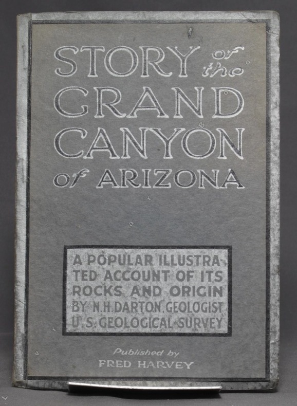
DARTON N. H:
Story of the Grand Canyon of Arizona. A popular illustrated account of its rocks and origin.
Kansas City, Fred Harvey, sans date. In-8 broché de 74-[6] p., couverture grise imprimée noir et argent.
Referentie van de boekhandelaar : 6257
|
|
|
Darby, Ben
Journey Through the Weald
No marks or inscriptions. A lovely clean very tight copy with bright unmarked boards and no bumping to corners. Dust jacket not price clipped or marked or torn or creased with slight traces of handling. 207pp. A descriptive, historical, geological, natural, architectural tour of the Weald from Romney Marsh to the village of Selbourne.

|
|
|
Dard, Antoine
Chez les ennemis d'Israël. Amorrheéns - Philistins. Hors texte, Cartes et Illustrations.
Paris, Victor Lecoffre 1906. (6) 331 (2) Seiten, mit mehreren Abbildungen auf Tafeln, Kl. 8° (17,5 x 12 cm), Priv.-Halbleineneinband.
Referentie van de boekhandelaar : 40636

|
|
|
Dardanellen.
Hellespont ou Detroit des Dardanelles pour servir de renseignement a la Carte des Limites des trois Empires ou Théatre de la Guerre presente 1788. [Paris], o. Dr., 1788.
Gest., alt ankolorierte Karte, Plattenmaß 645:295 mm (Blattmaß 666:340 mm). Unter Passepartout (800:455 mm). Zeigt die 65 Kilometer lange Meerenge der Dardanellen zwichen Ägäis und Marmarameer. Vier zusätzliche kleine Pläne (je 75:54 mm) zeigen "Les Forts des Dardanelles armes in Guerre", nämlich den "nouveau chateau d'Asie construit en 1658", den "nouveau chateau d'Europe construit en 1658", den "vieux chateau des Dardanelles en Asie" sowie den "vieux chateau d'Europe ou Dardanelle". 1788 trat Österreich in den Russisch-Türkischen Krieg ein. - Mit zeitgenössischem grünem Grenzkolorit. BM Cat. Maps 43980 (4).

|
|
|
Darlington, William.
FLORA CESTRICA. An Herborizing Companion for the Young Botanists of Chester County. Third Edition.
pp. 598 + Colored Map. XLib. (withdrawn). Some foxing and damp stain. Original full leather binding. Front board and spine almost detached. Early ownership of J.G. Getchell. William Darlington (1782-1863) was a Chester County physician and botanist, and a member of the U.S. House of Representatives from PA. He became a botanist at an early age, studied medicine, and graduated from the medical department of the University of Pennsylvania at Philadelphia in 1804. He went to the East Indies as ship's surgeon in 1806. He returned to West Chester in 1807 and was a practicing physician there for a number of years. He raised a company of volunteers at the beginning of the War of 1812 and was major of a volunteer regiment. Darlington was elected as a Democratic-Republican to the Fourteenth Congress; the Sixteenth; and the Seventeenth Congresses. He was appointed canal commissioner in 1825, and served as president of the West Chester Railroad. He established a natural history society in West Chester in 1826 and published several significant works on botany and natural history. Sabin 18596. The best edition. PA22
|
|
|
DAUMONT (Jean-François).
[BOMBAY/MUMBAI] Vista en perspectiva de la isla de Bombay en Africa, cerca de la costa de Malabar, Reyno de Visapour, baxo la dominacion del Rey de la Gran Bretaña.
Paris, Daumont, [circa 1770]. 486 x 339 mm.
Referentie van de boekhandelaar : LBW-4004

|
|
|
DAUSSY (Pierre).
[MARSEILLE & PIOMBINO] Carte des côtes de la mer Méditerranée. Partie comprise entre Marseille et Piombino.
[Paris], Dépôt-Général de la Marine, 1832. 605 x 885 mm.
Referentie van de boekhandelaar : LBW-8314

|
|
 De zoekresultaten per email ontvangen
 Zoekresultaten downloaden als PDF
 RSS feed


