|
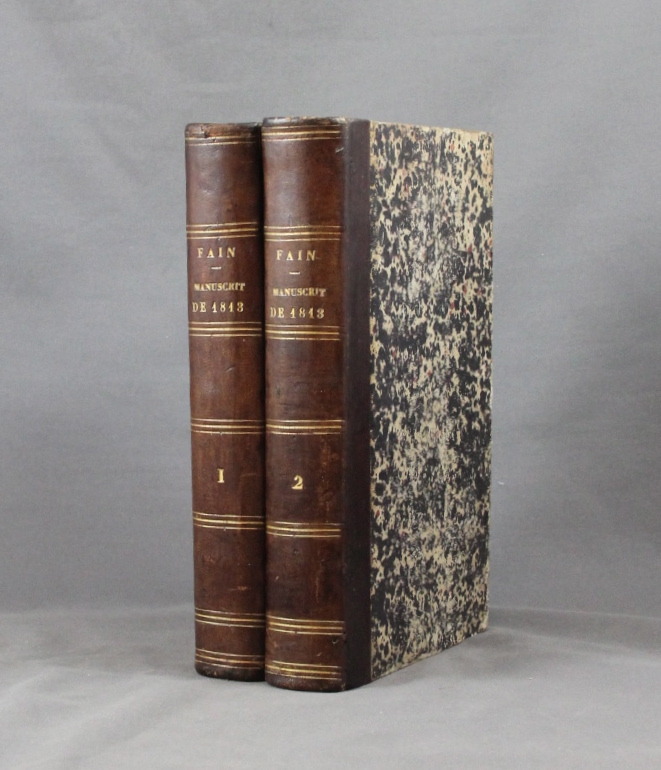
FAIN Baron:
Manuscrit de Mil huit cent treize, contenant le précis des événemens de cette année, pour servir à l’histoire de l’empereur Napoléon.
Paris, Delaunay, 1829. 2 volume in-8 de VI-493 + 556 pages, demi-basane marron, dos lisses ornés. Coiffes et dos légèrement frottés, pâle auréoles sur quelques feuillets.
Référence libraire : 1765
|
|
|
Fairgrieve, J. & Ernest Young
The British Isles
252 pages, maps, figures, appendix, index, name of a previous owner on the front endpaper. (The Human Geographies Secondary Series ; Book 1) eng
|
|
|
Fajana A. & B. J. Biggs illustrations by C. Pearson maps by G. Woodman
Nigeria in history
Ikeja: Longman Nigeria Ltd 1977. Paperback. viii 230p. preface appendices illustrations maps lightly-worn reprint trade paperback in red pictorial wraps. Longman Nigeria Ltd paperback
Référence libraire : 170527 ISBN : 0582602424 9780582602427

|
|
|
Fajana A. & B. J. Biggs illustrations by C. Pearson maps by G. Woodman
Nigeria in history
Ikeja: Longman Nigeria Ltd 1977. Paperback. viii 230p. preface appendices illustrations maps lightly-worn reprint trade paperback in red pictorial wraps. Longman Nigeria Ltd paperback books
Référence libraire : 170527 ISBN : 0582602424 9780582602427
|
|
|
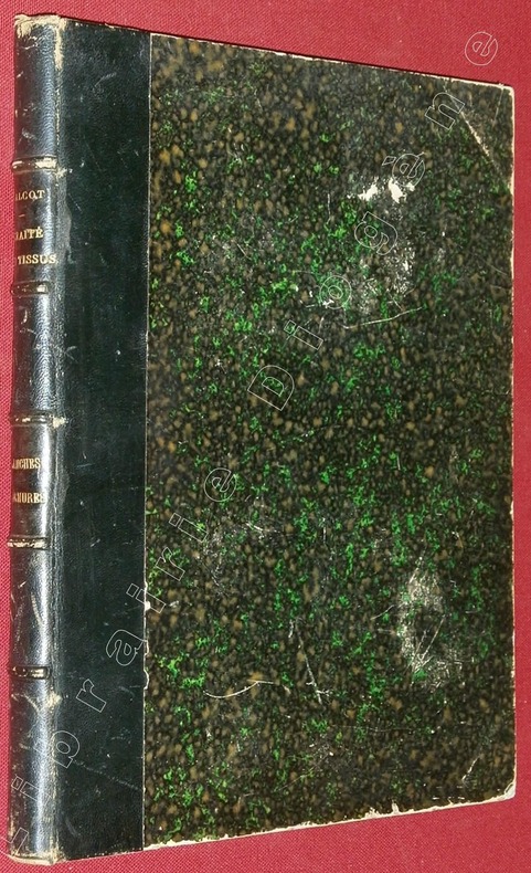
FALCOT, P.
Atlas des Planches d'Armures, brefs, dessins et mises en cartes, faisant suite au Traité de la Fabrication des Tissus, par P. Falcot, dessinateur.
A Elbeuf (sur Seine), chez l'Auteur, à Mulhouse, chez J.P. Risler, Libraire, 1852, 1 volume de 220x280x20 mm environ, complet de 89 planches+ pl. de titre, demi basane bleu marine, dos à 5 nerfs portant titres dorés, gardes marbrées. Mors internes en partie fendus, frottements sur le cuir et le cartonnage, coupes et coiffes émoussées, intérieur bon état.
Référence libraire : 82982
|
|
|
Falls Cyril. Maps by BG. Lewis. B. G.
A HUNDRED YEARS OF WAR.
Gerald Duckworth London 1953. 419 pp 8vo 8 5/8" H hard cover in dust jacket. 20 b&w battle maps. ".provides a sketch of the past century 1850-1950 of warfare by land sea and air with a commentary in interpretation of it. The emphasis is always on the military aspects of war - strategy tactics weapons administration transport and new scientific developments - rather than on political and moral issues.Five chapters each are devoted to World War I and II; single chapters to the American Civil War the Franco-Prussian War the Boer and the Russo-Japanese Wars taken together the Far Eastern campaigns from 1910 onwards and the present-day Communist offensive in Asia; subsidiary chapters deal with the many minor campaigns of the last century with the emergence of modern air power with administration in the field and with the special problems of guerilla and partisan warfare." Area of light browning to pages 84 & 85 at gutter due to previously laid in newspaper clipping small area of delamination to cloth on front board light wrinkling at top/bottom of spine very light edge wear. Dust jacket has minor edge wear light edge wrinkling several small closed tears and chips fading to spine color slight fading on rear panel several small watermarks on spine minor soiling. VG-/G. Gerald Duckworth, London, (1953). hardcover
Référence libraire : 12973

|
|
|
Falls Cyril/Carnes John maps
Armageddon: 1918 Great War Stories Series
Annapolis: Nautical and Aviation Publishing Co. 1979. 2nd edition. VG/VG dust jacket. xx 200 p. maps notes biblio index 8vo; Nautical and Aviation Publishing Co. hardcover
Référence libraire : 51925 ISBN : 0933852053 9780933852051

|
|
|
Falls Cyril Maps By A. F. Becke0
Egypt and Palestine Volume 2
Battery Press 1996-01-01. Hardcover. New. Volume 2 Part 2 of the 'Military Operations Egypt and Palestine set published by the Battery Press in 1996. BRAND NEW! In Protective Shrinkwrap! A Red Cloth-bound Hardcover with gold spine titles in NEW pristine condition. We ship all orders with delivery confirmation! Battery Press hardcover
Référence libraire : NG3-218 ISBN : 0898392403 9780898392401
|
|
|
Falls Cyril comp. A. F. Beck maps
Military Operations Macedonia: from the Spring of 1917 to the End of the War
London / Nashville: Imperial War Museum / Battery Press 1930. 1st ed. thus. orig. cloth. New Book. 8vo. xvi 365pp. maps & plans appends. indexes Official History of the Great War. Facsimile of the original 1935 edition. Large folding map in rear pocket Imperial War Museum / Battery Press hardcover
Référence libraire : 65119
|
|
|
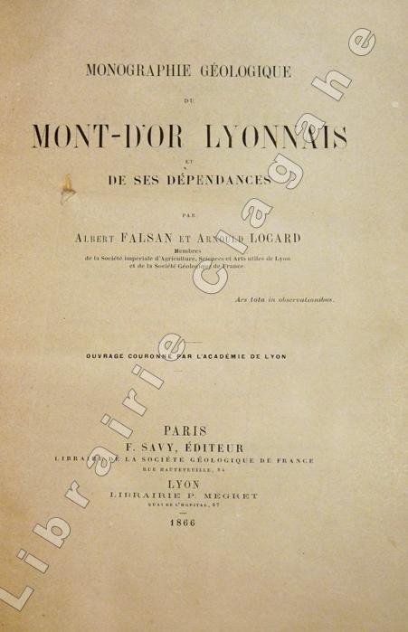
Falsan, Albert et Locard, Arnould :
Monographie géologique du Mont-d'Or lyonnais et de ses dépendances.
Paris, Savy et Lyon, P. Mégret (Lyon, Imprimerie Pitrat Aîné), 1866 ; in-8 ; demi-veau glacé bronze, dos à nerfs, titre doré, exemplaire juste ébarbé (reliure de l'époque) ; 499, (1) pp., 6 tableaux dépliants dont 1 très grand sur les étages géologiques, 4 planches hors-texte lithographiées dont 2 dépliantes et 1 grande carte géologique dépliante lithographiée en couleurs qui indique aussi les carrières, sablières, mines et emplacements de fossiles.
Référence libraire : 5649
|
|
|
FALSAN, Albert, & LOCARD, Arnould.:
Carte géologique du Mont-d'Or Lyonnais et de ses dépendances.
Chromolithographed map, scale 1:20,000, meas. 68x66cm, dissected and mounted on linen, folding back to 23x23x14.3cm. -Rare detailed map published along with (and belonging to?) the rare "Monographie géologique du Mont-d'Or Lyonnais" (Paris 1866).
|
|
|
Fanlac, Pierre (editor)
The Font de Gaume Cave - in Perigord
Booklet is 'as new' condition. 48pp. The history of the prehistoric cave paintings at the Font-de-Gaume cave near Les Eyzies in Perigord, France.

|
|
|
FANTASIO
Cannes, chandelles et baguettes magiques.
Strasbourg, Editions du Spectacles, 1984. 15 x 22, 91 pp., 135 figures, broché, bon état.
Référence libraire : 36713
|
|
|
FANTINI E
LE POKER COMMENT JOUER COMMENT GAGNER COMMENT CONJURER LE MAUVAIS SORT
De Vecchi 191976. In-8 broché de 142 pages.Bon état
|
|
|
FANTINI E
LE POKER COMMENT JOUER COMMENT GAGNER COMMENT CONJURER LE MAUVAIS SORT
de Vecchi De Vecchi 191976. In-8 broché de 142 pages.Bon état
Référence libraire : 36080
|
|
|
Farb Peter Illustrated by Photos Maps
Face Of North America
Harper. Used - Good. Good condition. Acceptable dust jacket. Harper unknown
Référence libraire : N12D-00282
|
|
|
Farb Peter Illustrated by Photos Maps
Face Of North America
Harper. Used - Acceptable. Acceptable condition. Book Good. No dust jacket. Harper unknown
Référence libraire : H02B-00811
|
|
|
Farb Peter Illustrated by Photos Maps
Face Of North America
Harper 1963-01-01. Hardcover. Very Good. Book is very clean. Crisp pages. Tight binding. Good reading copy. Slight shelf wear on cover. Light tanning. - All products inspected inside and out and shipped by USPS with a tracking number! I highly suggest that you choose expedited shipping. For a small fee you get priority shipping insurance and a padded envelope for the best protection. Harper hardcover
Référence libraire : 36XCT86C4

|
|
|
Farrell Odgers Sally; Hinch Jennifer maps.
Tasmania - A Guide.
Sydney Kenthurst: Kangaroo Press 1991. Reprint ed. Paperback trade very good condition black & white text-photos maps minor edgewear. 224 pp. This comprehensive book looks at places of historic and scenic interest and includes a number of tourist attractions specifically designed for young travellers. The author a Tasmanian herself has travelled most of the routes and explored many of the places she writes about. Kangaroo Press paperback
Référence libraire : 28527 ISBN : 0864172362 9780864172365
|
|
|
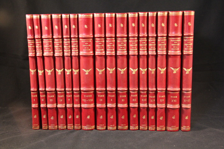
FATIO V. Dr. et STUDER Th. Dr:
Catalogue des oiseaux de la Suisse.
Genève et Berne, Département fédéral de l’industrie et de l’agriculture (division des Forêts), 1889- 1939. 17 livraisons reliées en 16 volumes in-8 (15. 8x24. 3) demi veau rouge, dos à nerfs ornés de filets et de fers (2 types d’oiseaux) dorés, roulette dorée sur les plats et beau papier de recouvrement à motif d’oiseaux.En parfaite condition.
Référence libraire : 300
|
|
|
FAUCOU (Lucien).
Plan de la ville de Paris. Période révolutionnaire (1790-1794).
Paris, 1889. 794 x 994 mm, monté sur toile, replié.
Référence libraire : LBW-5808

|
|
|
Faune:
Le sol est vivant - reflets d'un monde méconnu.
Confédération suisse, Office fédéral de l'environnement, 2015. Carnet de 12 grandes cartes postales au format 21 x 15 cm. Photographies de ce qu'il y a sous nos pieds.
Référence libraire : 4233

|
|
|
Faupel, W. John
Faupel's Catalogue Nr. 104.
East Grinstead, Februar 1993. 18 n.n. SS., zahlreiche s.w. Abbildungen. Ca. 29 x 14, 5 cm, illustr. original Broschur, klammergeheftet.
Référence libraire : 23971
|
|
|
FAVELAC P.-M.
Les Tables à Jeux
sd Editions Ch. Massin - Sans date - In-4 cartonnage toile rouge de l'éditeur avec titre en blanc sur le premier plat, jaquette illustrée - 64 pages - Nombreuses reproductions photographiques en couleurs in-texte
Référence libraire : 93575
|
|
|
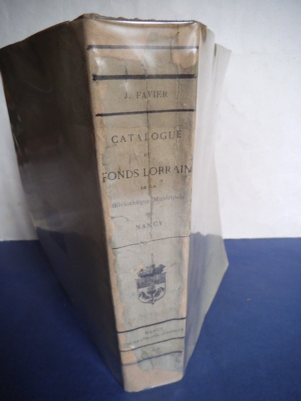
FAVIER J.
Catalogue de livres et documents imprimés du fonds Lorrain de la bibliothèque municipale de Nancy
dressé et publié sous la direction de J Favier in 8 broché faux-titre, titre,IX,794 pages,texte sur 2 colonnes Nancy A.Crépin-Leblond 1898 couverture doublée.Bon exemplaire
Référence libraire : 8362
|
|
|
FAVRE Alphonse:
Recherches géologiques dans les parties de la Savoie du Piemont et de la Suisse voisine du Mont-Blanc, avec un atlas de 32 planches.
Paris et Genève, Victor Masson et filles, 1867. 3 volumes in-8 de XX-464 + [4]-437-[3] + [4]-587-[4]p. pour l'errata, demi-veau brun, dos à nerfs ornés de filets et fleurons dorés, coupes et coiffes inférieures frottées, quelques rousseurs. 1 volume in-folio pour l'atlas, relié en demi-vélin blanc à coins, pièces de titre rouge au premier plat.
Référence libraire : 14955
|
|
|
Faxon Lavinia; Maps by Alan Price
A YOUNG EXPLORER'S NEW YORK; Maps of Manhattan
Greenwich Ct: NY Graphic Society 1962. 1st edition. Hardcover. Good. oblong quarto blue cloth spine over blue illustrated boards 1st ed. 1962 59 pages NO DJ. Exterior edgeworn corners bumped & worn; text clean / unmarked. NY Graphic Society hardcover
Référence libraire : CE235478

|
|
|
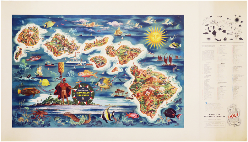
FEHER (Joseph).
[HAWAII] The Dole map of the Hawaiian Islands.
Honolulu & San Francisco, Hawaiian Pineapple Company Limited, 1950. Lithographie en couleurs de 475 x 960 mm.
Référence libraire : LBW-7046
|
|
|
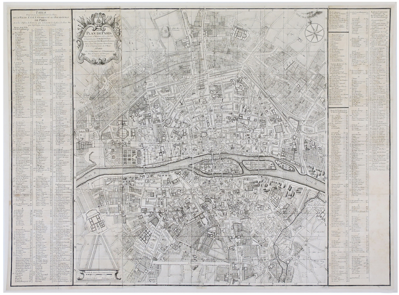
FELIBIEN (Dom Michel) & LOBINEAU (Dom Guy-Alexis).
Plan de Paris pour servir à l'histoire de la ditte ville composée par D. Michel Félibien et mise au jour par D. G. Alexis Lobineau.
Paris, G. Desprez et J. Desessartz, 1726. En 40 sections jointes de 630 x 860 mm, monté sur toile.
Référence libraire : LBW-3558
|
|
|
FELIX H.
Nouvelle collection de tours de cartes. Ouvrage complet renfermant les préceptes et les instructions élémentaires théoriques et pratiques indispensables pour bien réussir dans cet art
Paris Bernardin s.d. (vers 1900) in-12 de 108 pp. broché, couv. imp
Référence libraire : 16976
|
|
|
Fell RT. R. T.
Early Maps of South-east Asia Images of Asia
Singapore: Oxford University Press 1991 The mapping of southeast Asia is a story of adventure and endeavour involving many nationalities over many years. This edition contains an updated and expanded introduction which concentrates on the work of famous European map-makers especially the cartographers of the British and Dutch East India companies. As well as explaining the history and artistic importance of the maps and their makers from the earliest times to the late 19th century the book also advises on collecting and caring for old maps.122p. illus bibliography.index. 2nd Edition. Laminated HC. New/No Jacket. Oxford University Press hardcover
Référence libraire : 29217 ISBN : 019588972X 9780195889727
|
|
|
Fenart Madeleine
Arradon et son passé si proche
Petit in-4 reliure pleine toile bleue en très bon état de 52 pages
Référence libraire : yam0109
|
|
|
Fenner
FENNER'S POCKET ATLAS of Modern & Ancient Geography
London: Robert Jennings Undated but 1831 & 1828; title continues "Divided according to the General Treaty of Peace by Congress in 1815 & exhibiting Parry Ross & Franklin's Discoveries to the Present Period" two parts in one: calligraphic title pages to each vol and calligraphic contents list 55 numbered map leaves in the first part including one double page comparison plate of mountains and rivers and eight double page maps double maps include Hemisphere maps World Map Ottoman Empire Chinese Empire Canada United States etc.; 26 numbered map leaves in the secont part of which one double page; all correct and in accordance with the lists of plates all hand coloured in outline and the comparision mountains and rivers page also hand coloured. Contemporary half calf binding with black title label gilt to the spine cloth covered boards binding good and strong with some general wear and rubbing accomplished repair to the base of the spine and front joint corners a little more worn small chip to head of the spine. Contents clean and tight original end papers a little reading wear and age marking a few finger marks to margins the odd ink mark and foxing spot folding world map with short 35mm split along folding section. A very good complete copy. Hardcover. Very Good/No Dust Jacket. Robert Jennings Hardcover
Référence libraire : 022667

|
|
|
Fenning, D. and J. Collyer
An Encyclopaedia of North and South America 1786. Reprint Edition
Unwin Brothers, London, 1976. 29,5 cm ; kart.
Référence libraire : 86806

|
|
|
FENOUIL M
Carte routière et vicinale du département de l'Hérault dressée sous l'administration de J.M Pietri préfet officier de la Légion d'Honneur. Arrondissement de Montpellier
Sans nom ni lieu, 1862. Carte entoilée "arrondissement de Montpellier" de 8 feuilles entoilées mesurant 59 x 46.5 cm chacunes. L'ensemble replié dans un étui cartonné, titre sur le plat. Feuille 1 : Gorniès, St André de Buèges, etc. Feuille 2 : Ganges, Moulès et Baucels, Montoulieu, etc. Feuille 3 : Vcquières, St Bauzille de Montmel, Buzignargues, Galargues, etc. Feuille 4 : St Guilhem le Désert. Puéchabon. Aniane. La Boissière etc. Feuille 5 : Viols en Laval. Cazevieille. St Jean de Cuculls. etc. Feuille 6 : Castries, Baillargues. Dt Brès. Valergues. Etc. Feuille 7 : Montoulieu, Gigean, Poussan, Villeveyrac, Loupian, Mèze, Cette, Bouzigues, Balaruc, Frontignan. Feuille 8 : Pérols, Lattes, Palavas, Villeneuves les Maguelones, Fabrègues, Vic, Mireval. Echelle de 23 dixmillièmes de mètre pour 100 mètres ou de 1/43200. Toutes les feuilles sont revétues du cachet de E. Chabanon, Notaire à Ganges (Hérault). Photographe amateur, ce dernier réalisa pour A.E. Martel célèbre spéléologue, nombreuses photographies. Etui taché sinon Bel état

|
|
|
FENOUIL M
Carte routière et vicinale du département de l'Hérault dressée sous l'administration de J.M Pietri préfet officier de la Légion d'Honneur. Arrondissement de Montpellier
Sans lieu Sans nom ni lieu, 1862. Carte entoilée "arrondissement de Montpellier" de 8 feuilles entoilées mesurant 59 x 46.5 cm chacunes. L'ensemble replié dans un étui cartonné, titre sur le plat. Feuille 1 : Gorniès, St André de Buèges, etc. Feuille 2 : Ganges, Moulès et Baucels, Montoulieu, etc. Feuille 3 : Vcquières, St Bauzille de Montmel, Buzignargues, Galargues, etc. Feuille 4 : St Guilhem le Désert. Puéchabon. Aniane. La Boissière etc. Feuille 5 : Viols en Laval. Cazevieille. St Jean de Cuculls. etc. Feuille 6 : Castries, Baillargues. Dt Brès. Valergues. Etc. Feuille 7 : Montoulieu, Gigean, Poussan, Villeveyrac, Loupian, Mèze, Cette, Bouzigues, Balaruc, Frontignan. Feuille 8 : Pérols, Lattes, Palavas, Villeneuves les Maguelones, Fabrègues, Vic, Mireval. Echelle de 23 dixmillièmes de mètre pour 100 mètres ou de 1/43200. Toutes les feuilles sont revétues du cachet de E. Chabanon, Notaire à Ganges (Hérault). Photographe amateur, ce dernier réalisa pour A.E. Martel célèbre spéléologue, nombreuses photographies. Etui taché sinon Bel état
Référence libraire : 164273

|
|
|
FER (Nicolas de)
[Carte géographique]. Le Cercle de Souabe et partie de Celuy de Franconie.
Paris, Chez l'auteur, fin XVII°s. 60,7 x 47,3 cm à la cuvette + marges.
Référence libraire : 14261
|
|
|
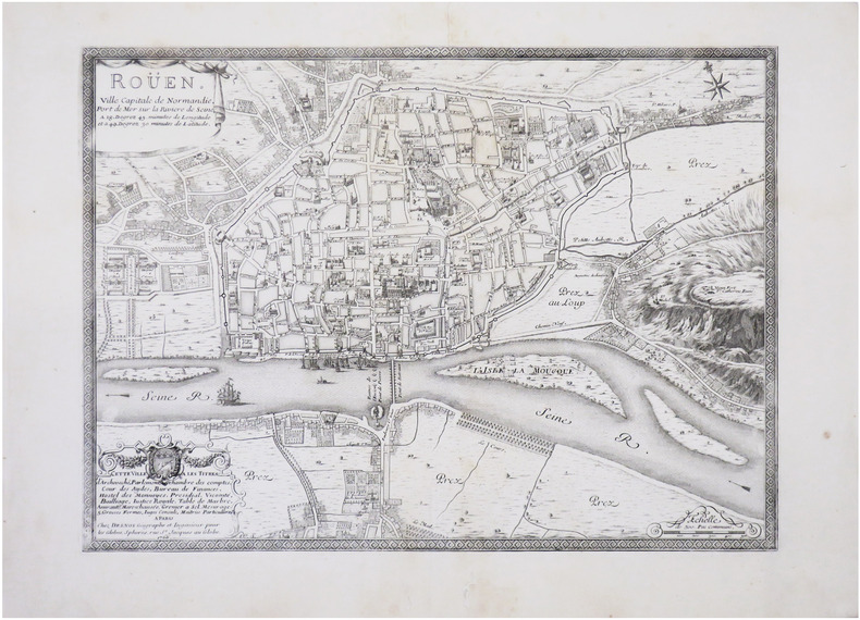
FER (Nicolas de) & DESNOS (Louis-Charles).
[ROUEN] Roüen, ville capitale de Normandie, port de mer sur la rivière de Seine.
Paris, Desnos, 1766. 398 x 547 mm.
Référence libraire : LBW-8594
|
|
|
FER (Nicolas de).
[BALÉARES/MAJORQUE] L'Isle Mayorque.
234 x 342 mm + feuillet de texte descriptif.
Référence libraire : LBW-716

|
|
|
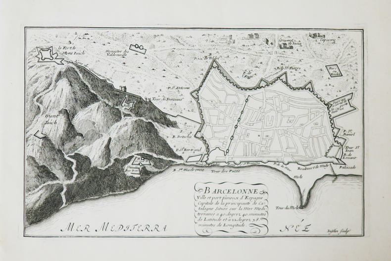
FER (Nicolas de).
[BARCELONE] Barcelonne ville et port fameux d'Espagne.
[1690-1695]. 166 x 270 mm.
Référence libraire : LBW-4822
|
|
|
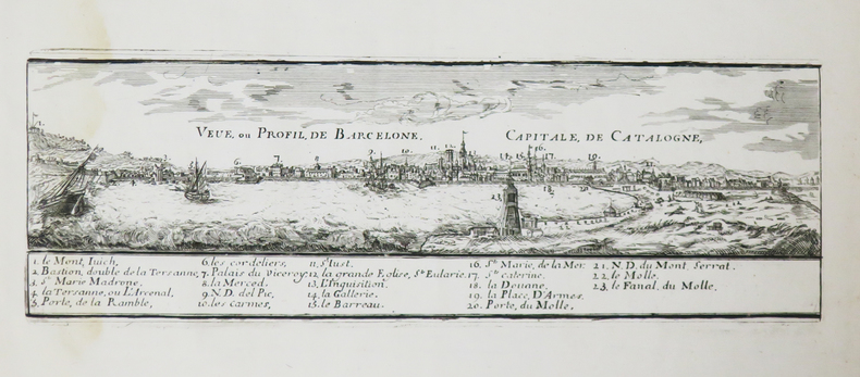
FER (Nicolas de).
[BARCELONE] Veue, ou profil, de Barcelone, capitale de Catalogne.
[1690-1695]. 93 x 288 mm.
Référence libraire : LBW-4836
|
|
|
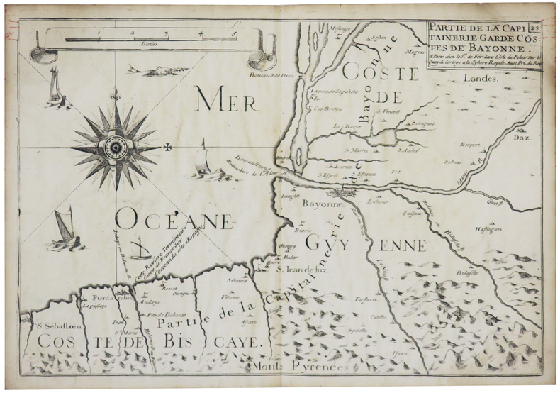
FER (Nicolas de).
[BAYONNE] Partie de la capitainerie garde costes de Bayonne.
Paris, Sr. de Fer, [1690]. 224 x 328 mm.
Référence libraire : LBW-5664
|
|
|
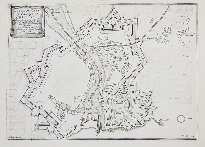
FER (Nicolas de).
[BELLE-ÎLE-en-MER] Bourg ou ville, et palais de Bell'Isle, située dans une isle de même nom, sur la coste méridionale de Bretagne.
Paris, Sr. de Fer, [1690-1695]. 214 x 299 mm.
Référence libraire : LBW-4453
|
|
|
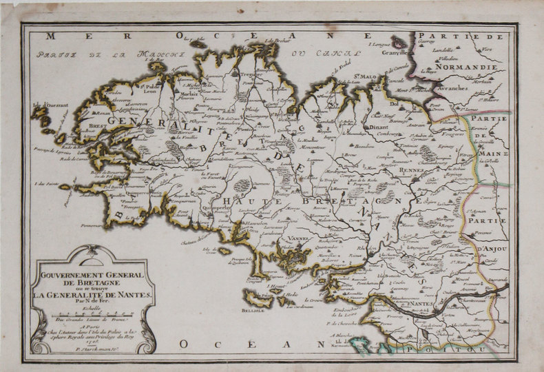
FER (Nicolas de).
[BRETAGNE] Gouvernement général de Bretagne où se trouve la généralité de Nantes.
Paris, chez l'auteur, 1705. 242 x 353 mm + feuillet de texte.
Référence libraire : LBW-3188
|
|
|
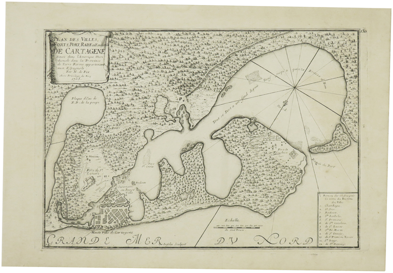
FER (Nicolas de).
[CARTHAGÈNE/COLOMBIE] Plan des villes, forts, port, rade et environs de Cartagène située dans l'Amérique méridionale dans la province de Terre Ferme appartenant aux Espagnols.
1705. 225 x 322 mm + feuillet de texte descriptif.
Référence libraire : LBW-6085
|
|
|
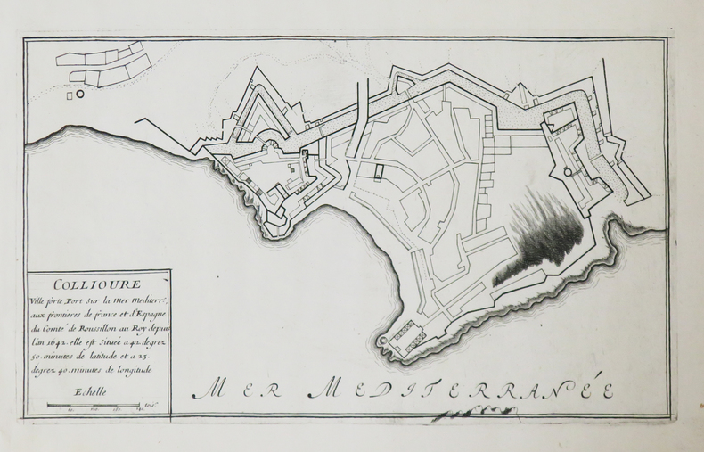
FER (Nicolas de).
[COLLIOURE] Collioure ville forte, port sur la mer Méditerranée.
[1690-1695]. 170 x 288 mm.
Référence libraire : LBW-4823
|
|
|
FER (Nicolas de).
[ESTONIE] Plan de Narva.
Paris, 1705. 226 x 336 mm.
Référence libraire : LBW-712
|
|
|
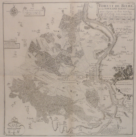
FER (Nicolas de).
[FONTAINEBLEAU] Forest de Bière ou de Fontaine-bleau contenant 13212 arpens en bois tant bien que mal planté non compris les rochers et bruyères.
Paris, G. Danet, 1705 [circa 1720]. 429 x 420 mm.
Référence libraire : LBW03934
|
|
|
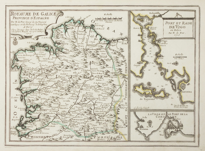
FER (Nicolas de).
[GALICE] Royaume de Galice province d'Espagne.
Paris, chez l'auteur, 1705. 236 x 327 mm.
Référence libraire : LBW-2894
|
|
|
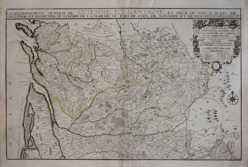
FER (Nicolas de).
[GUYENNE & GASCOGNE] Le gouvernement général de Guienne et Gascogne et ceux du Pays d'Aunis, de Saintonge et Angoumois, du Limosin, de la Marche, du Pays de Foix, de Navarre et Béarn.
Paris, J.F. Bénard, 1711. 472 x 713 mm.
Référence libraire : LBW-3044
|
|
 Recevoir par e-mail
 Télécharger en PDF
 Flux RSS


