|
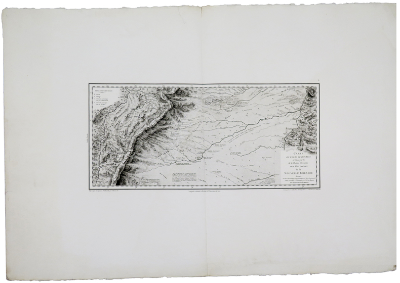
HUMBOLDT (Frédéric-Henri-Alexandre, baron de).
[COLOMBIE/BOGOTA] Carte du cours de Rio Meta et d'une partie de la chaîne orientale des montagnes de la Nouvelle Grenade.
[Paris], 1813. 232 x 495 mm.
Ссылка продавца : LBW-5880
|
|
|
HUMBOLDT (Frédéric-Henri-Alexandre, baron de).
[MEXIQUE/MEXICO] Carte de la vallée de Mexico et des montagnes voisines esquissée sur les lieux en 1804, par Don Louis Martin.
Paris, 1808. 392 x 457 mm.
Ссылка продавца : LBW-5869

|
|
|
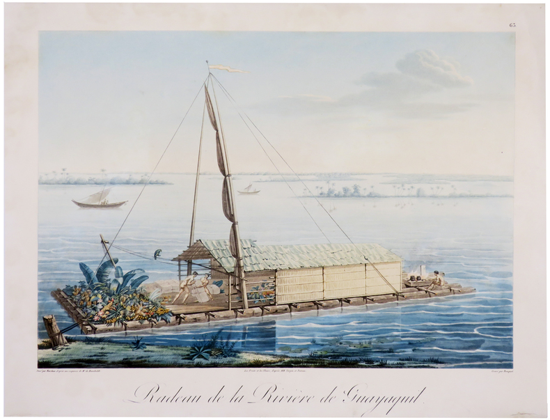
HUMBOLDT (Frédéric-Henri-Alexandre, baron de).
[ÉQUATEUR/GUAYAQUIL] Radeau de la rivière de Guayaquil.
[1810]. 335 x 411 mm.
Ссылка продавца : LBW-6012
|
|
|
Hungary Folding pocket size travel map with metro map Streetwise Maps Budapest
Streetwise Budapest Map - Laminated City Center Street Map of
11. unknown
Ссылка продавца : hallmark-v6yh ISBN : 1886705224 9781886705227

|
|
|
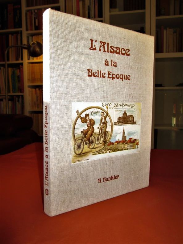
HUNKLER Robert (docteur)
L'Alsace à la Belle époque (1870-1914)
SPRL, SODIM 1976. Album in-4 relié (28,5 x 20,5 cm), reliure éditeur pleine toile écrue, premier plat orné d'une vignette en couleurs, titre imprimé à froid en marron, 152 pages, richement illustré de reproductions de cartes postales anciennes.-700g.L. - Très frais, excellent état.
Ссылка продавца : 25936
|
|
|
Hunt Frazier Maps by Robert N Mullin
The Tragic Days of Billy the Kid
Hastings House. Hastings House. unknown
Ссылка продавца : 16755

|
|
|
Hunt, Lindsay & Phillips, Laurence
The AA Key Guide to Brittany
No marks or inscriptions. No creasing to covers or to spine. A very clean very tight copy with bright unmarked boards and no bumping to corners. 222pp. Brittany's sights, restaurants, bars, hotels, shopping, walks, tours, trains, buses and Metro in a beautifully laid out guide with user-friendly maps.

|
|
|
Hunter C.; Maps Drawings Illustrator
TSAVO NATIONAL PARK
Ines May - Publicity 1/1/1975. Paperback. Very Good. NICE CONDITION SLENDER SOFTCOVER TRAVEL GUIDEBOOK IN STAPLED WRAPS. NO WRITING OR MARKINGS IN TEXT. ONLY LIGHT WEAR TO COVER. A CLEAN & SOLID BOOK. Ines May - Publicity paperback
Ссылка продавца : SKU-99060
|
|
|
Hunter, W. V.
Exploring Cornwall with Your Car
Booklet in mint unused condition. 48pp.

|
|
|
HUNTINGDONSHIRE - BLAEU, J.W.
Huntingdonensis Comitatus. Huntington Shire.
(Amsterdam, 1645 or later). 39,2x50 cm. Fine engraved map over Huntingdon, broad margins, fine orig. handcolouring. Clean. Large cartouche with dogs and huntingscenes. Map decorated with many large coats of arms.
|
|
|
HUNTINGDONSHIRE - BLAEU, J.W.
Huntingdonensis Comitatus. Huntington Shire.
(Amsterdam, 1645 or later). 39,2x50 cm. Fine engraved map over Huntingdon, broad margins, fine orig. handcolouring. Clean. Large cartouche with dogs and huntingscenes. Map decorated with many large coats of arms.
Ссылка продавца : 25260
|
|
|
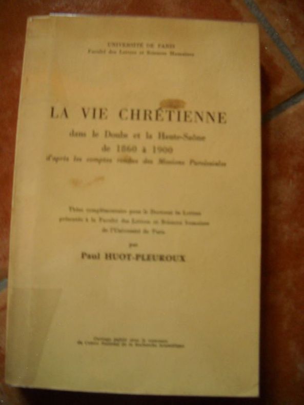
HUOT-PLEUROUX PaulLA VIE CHRETIENNE Dans Le DOUBS et La HAUTE-SAÔNE De 1860 à 1900, D'après Les Comptes Rendus Des Missions ParoissialesFaculté Des Lettres et Sciences Humaines In-8 Couverture Imprimée Paris 1966 Ouvrage broché, thèse complémentaire pour le doctorat ès lettres présentée àla faculté des lettres et sciences humaines de l'université de Paris, deux cartes dont un double d echacune sur papier calque figurent in fine,381 pages, état d'usage - Prix : 45,00 EUR Commander
LA VIE CHRETIENNE Dans Le DOUBS et La HAUTE-SAÔNE De 1860 à 1900, D'après Les Comptes Rendus Des Missions Paroissiales
brocheé - 15.5x24 - 381pp - 1966 - université de Paris
Ссылка продавца : 10890
|
|
|
HUSSON (Pierre);
[PAYS-BAS] Carte générale des Provinces Unies des Pais Bas & des terres voisines qui en dépendent avec leurs principales divisions.
La Haie circa 1710 500 x 575 mm.
Ссылка продавца : LBW045cc

|
|
|
Hutchinson Bruce maps: MacDonald James
STRUGGLE FOR THE BORDER
New York NY: Longmans Green & Company. G/NO DUSTJACKET. 1955. First Edition. Cloth. 8vo. 500 pp. spine faded endpapers stained . Longmans, Green & Company hardcover
Ссылка продавца : BOOKS18061
|
|
|
Hutchinson Bruce maps: MacDonald James
STRUGGLE FOR THE BORDER
New York NY: Longmans Green & Company. G/NO DUSTJACKET. 1955. First Edition. Cloth. 8vo. 500 pp. cover worn and stained some . Longmans, Green & Company hardcover
Ссылка продавца : BOOKS239767
|
|
|
Hutchinson, Joseph . [et al.]
Resource Development in Semi-Arid Lands : A Royal Society Discussion Organized by Sir Joseph Hutchinson, F.R.S., A.H. Bunting, A. R. Jolly and H.C. Pereira, F.R.S.
vii + 176 pages, illustrated, previous owner details on the front endpaper. Not ex library. eng
|
|
|
Hutchinson, Walter: Editor
Hutchinson's Pictorial History of the War, Series 3, No. 3, January 3, 1939 - , January 9, 1940
40 pages. Circa 1940s. 77 black and white photos and illustrations. Printed on glossy stock. Features: Ad for Mein Kampf, part 3, inside front cover; The army of France at the front; Ministerial and R.A.F. changes - photos of A.S. Barratt, Sir John Reith, Oliver Stanley and Sir Andrew Rae Duncan; Full-page photo of France honouring Sir Edmund Ironside and Lord Gort; Contraband control strangling Germany's tradep Nazi watch on the western front; Text of speech by Lord Snell entitled "The British Empire - In War and After"; Photo portrait of Admiral Sir Charles Forbes; Lumberjacks of the Land Girls Army; British tank gunners in training; Admiral Graf Spee visitors pay courtesy visits - the Ajax in Montevideo and the Achilles in Buenos Aires; Centerfold maps illustrate European industrial targets and bases most vulnerable to raids; At an R.A.F. Aerodrome in France; Norway prepares to defend her neutrality - 12 great photos; photo of partially submerged vessel Dunbar Castle which struck a German mine; photo of bombed Trinity House vessel which was attacked by a Nazi plane on January 9th; Illustrated article - The Royal Army Chaplain's Department; At an R.A.F. fighter station; A 25-pounder shoot at the front; Commentary on the war this week; Finland's fight for freedom - 8 excellent photos including one of a Soviet amphibious tank; Summary of the chief events of this week. Average wear. Unmarked. A sound copy. Book

|
|
|
Hyde FE / Markham SF / Green Charles W Drawings / Hyde Marian R Maps
A History of Stony Stratford and the Immediate Vicinity
Wolverton: McCorquodale and Co Ltd 1948. xi 192pp 2 folding maps 25 illustrations appendix. Red boards edge rubbing general ageing to contents corner creasing to the tips of a few pages edge nick/crease to one map. Overall a Good copy without dustwrapper. . First Edition. Hard Cover. Good/No Jacket. 8vo - over 7�" - 9�" tall. McCorquodale and Co Ltd Hardcover
Ссылка продавца : 021410

|
|
|
HYDROGEOLOGIE du BASSIN de l'AREUSE par André BURGER.
Hydrogéologie du bassin de l'Areuse. Richement documenté (héliogravures, figures, cartes dépliantes).
Neuchâtel 1959. Bel exemplaire relié, in-8, 304 pages + planches.
Ссылка продавца : AUB-6528
|
|
|
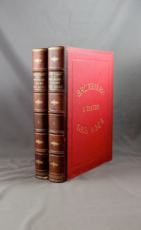
HYMANS Louis:
Bruxelles à travers les âges.
Bruxelles, Bruylant-Christophe et Cie, sans date. 2 volumes in-4 de 484 + 466 pages, demi-maroquin marron, dos à nerfs ornés, plats frappés du titre en lettres dorées et encadrés à froid, tranches dorées. Mors 1er plat vol. 1 légèrement fendu et frotté, accroc à la coiffe inf. vol. 1, mors 1er plat vol. 2 légèrement fendu et frotté.
Ссылка продавца : 2063
|
|
|
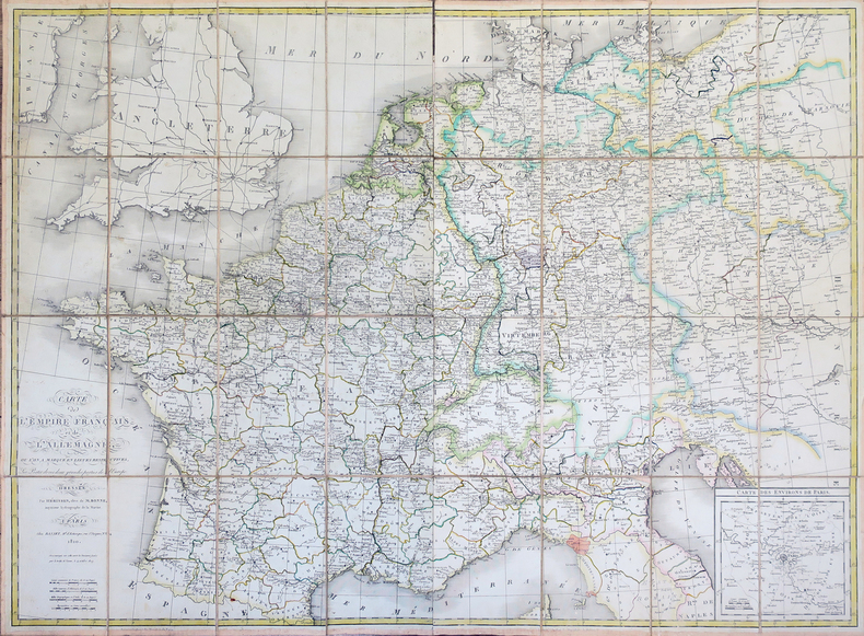
HÉRISSON (Eustache).
Carte de l'Empire Français et de l'Allemagne, où l'on a marqué en lieues respectives, les postes de ces deux grandes parties de l'Europe.
Paris, Basset, 1810. En deux feuilles non jointes, coupées en sections et pliées, pouvant former une carte de 0,78 x 1,06 m, sous étui.
Ссылка продавца : LBW-4320
|
|
|
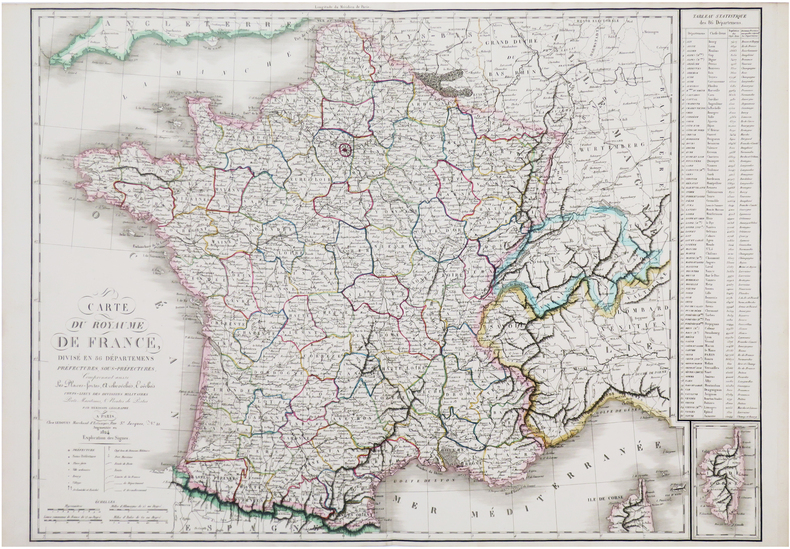
HÉRISSON (Eustache).
Carte du royaume de France divisé en 86 départemens, préfectures, sous-préfectures, comprenant aussi les places-fortes, archevêchés, évêchés, chefs-lieux des divisions militaires, ports maritimes, & routes de postes.
Paris, Ledoyen, 1824. 557 x 759 mm.
Ссылка продавца : LBW-7607
|
|
|
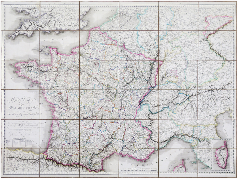
HÉRISSON (Eustache).
Carte routière du Royaume de France et des pays limitrophes, divisée en 86 départemens, et sous-divisée en arrondissemens, avec les établissemens politiques, militaires, civils, religieux, et la distance de Paris aux chefs-lieux de préfectures, marquée en lieues nouvelles de 2000 toises par la route la plus courte. Dessinée par Hérisson d'après les actes du Congrès de Vienne, & le Traité de Paix du 20 novembre 1815.
Paris, Basset, 1827. En 36 sections montées sur toile et pliées, formant une carte de 0,95 x 1,23 m.
Ссылка продавца : LBW-7047
|
|
|
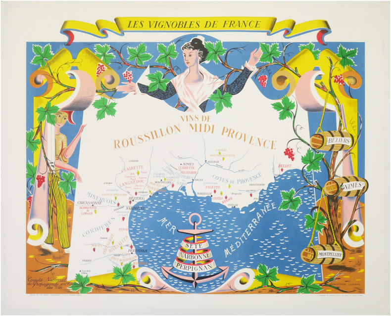
HÉTREAU (Rémy) & LEBLANC (Jean).
[VIGNOBLES] Les Vignobles de France. Vins de Roussillon Midi Provence.
Paris, C.N.P.V. Sopexa, 1954. 635 x 765 mm, montée sur toile.
Ссылка продавца : LBW-8126
|
|
|
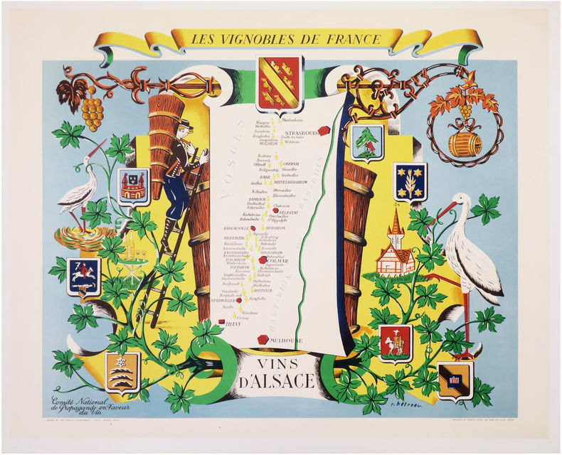
HÉTREAU (Rémy).
[VIGNOBLES] Les Vignobles de France. Vins d'Alsace.
Paris, C.N.P.V. Sopexa, 1954. 624 x 750 mm, montée sur toile.
Ссылка продавца : LBW-8112
|
|
|
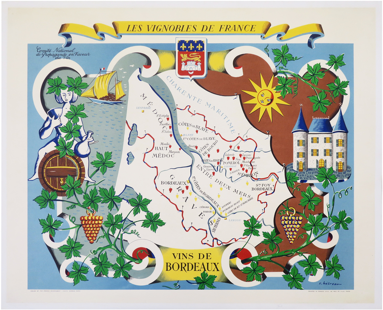
HÉTREAU (Rémy).
[VIGNOBLES] Les Vignobles de France. Vins de Bordeaux.
Paris, C.N.P.V. Sopexa, 1954. 620 x 754 mm, montée sur toile.
Ссылка продавца : LBW-8115
|
|
|
HÉTREAU (Rémy).
[VIGNOBLES] Les Vignobles de France. Vins de Bourgogne.
Paris, C.N.P.V. Sopexa, [1954]. 625 x 749 mm.
Ссылка продавца : LBW-8296

|
|
|
HÉTREAU (Rémy).
[VIGNOBLES] Les Vignobles de France. Vins de Roussillon Midi Provence.
Paris, C.N.P.V. Sopexa, [1954]. 630 x 758 mm, montée sur toile.
Ссылка продавца : LBW-6866

|
|
|
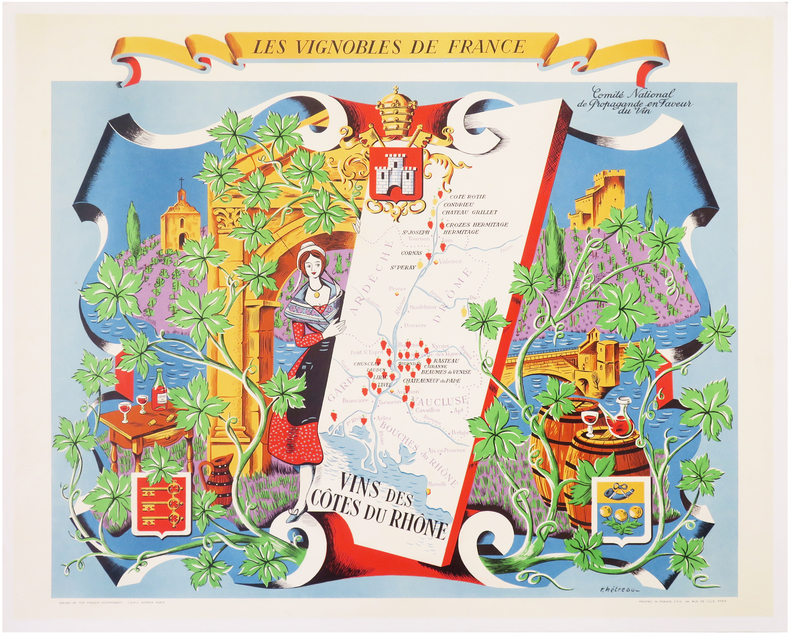
HÉTREAU (Rémy).
[VIGNOBLES] Les Vignobles de France. Vins des Côtes du Rhône.
Paris, C.N.P.V. Sopexa, 1954. 630 x 753 mm, montée sur toile.
Ссылка продавца : LBW-8125
|
|
|
HÉTREAU (Rémy).
[VIGNOBLES] Les Vignobles de France. Vins du Val de Loire.
Paris, C.N.P.V. Sopexa, [1954]. 620 x 750 mm.
Ссылка продавца : LBW-8295

|
|
|
HÜSEYIN HÜSNÜ EMIR [ERKILET], (Map maker), (1883-1958).
[OTTOMAN MAP of PALESTINE] Filistin haritasi. 2 sheets set.
Very Good Turkish, Ottoman (1500-1928) Original map. Oblong atlas folio. (57 x 77 cm). In Ottoman script. Folded. Stains on the upper side. Slightly chipped margins. Filistin haritasi. Scale: 1/250.000. Erkilet was an officer of the Ottoman Army and the general of the Turkish Army. In fall 1941 he, along with General Ali Fuad Erden, visited the occupied territories in Ukraine (including Crimea) on the invitation of Gerd von Rundstedt. From there he and other Turkish officers flew to Rastenburg to meet Hitler in person. In 1943 he published his essays on that trip under the title "What I Saw on the Eastern Front". Being a staunch Turanist, he was briefly detained for Panturkic activities in 1948 together with some other prominent Turanists.
|
|
|
HÜSEYIN HÜSNÜ EMIR [ERKILET], (Turkish map maker, author and soldier), (1883-1958).
[Original photograph of Hüseyin Hüsnü Emir Erkilet].
Very Good Turkish Original b/w photograph. 9x14 cm. It shows Erkilet and many women and men with a child around him. Probably it's taken during a travel. Erkilet was an officer of the Ottoman Army and the general of the Turkish Army. In the fall 1941 he, along with General Ali Fuad Erden, visited the occupied territories in Ukraine (including Crimea) on invitation of Gerd von Rundstedt. From there he and other Turkish officers flew to Rastenburg to meet Hitler in person. In 1943 he published his essays on that trip under title "What I Saw on the Eastern Front". Being a staunch Turanist, he was briefly detained for Panturkic activities in 1948 together with some other prominent Turanists.
|
|
|
HÜSEYIN HÜSNÜ EMIR [ERKILET], (Turkish map maker, author and soldier), (1883-1958).
[Original photograph of Hüseyin Hüsnü Emir Erkilet].
Very Good Turkish Original b/w photograph. 9x14 cm. It shows Erkilet and two other men and a woman sitting around a table. Erkilet was an officer of the Ottoman Army and the general of the Turkish Army. In the fall 1941 he, along with General Ali Fuad Erden, visited the occupied territories in Ukraine (including Crimea) on invitation of Gerd von Rundstedt. From there he and other Turkish officers flew to Rastenburg to meet Hitler in person. In 1943 he published his essays on that trip under title "What I Saw on the Eastern Front". Being a staunch Turanist, he was briefly detained for Panturkic activities in 1948 together with some other prominent Turanists.
|
|
|
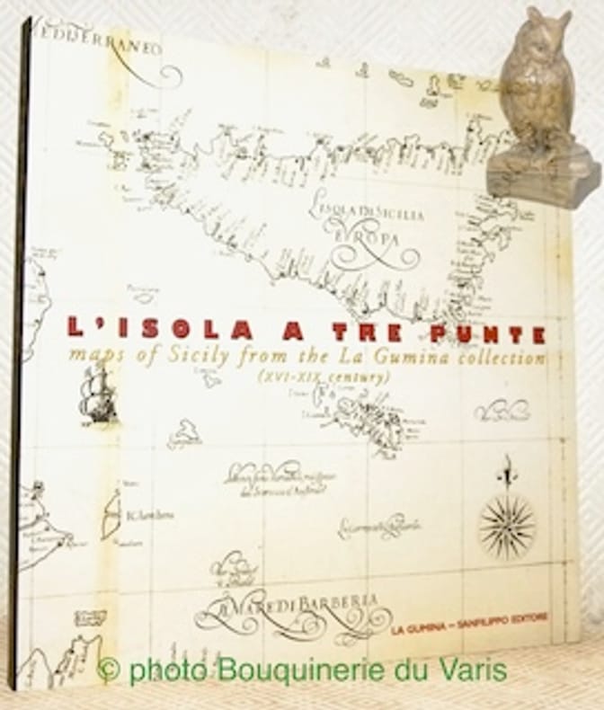
Iachello, Enrico.
L’isola a tre punte maps of Sicily from the La Gumina collection (XVIe-XIX Century).
Catania, La Gumina - Sanfilipo Editore 1999, 230x220mm, 191pages, paperback. Book in good condition.
Ссылка продавца : 110522
|
|
|
ILHAN PINAR
Izmir city plans and maps from the Ottoman Era.= Osmanli dönemi Izmir planlari ve haritalari.
New English Original decorative cloth bdg. Folio. (33 x 33 cm). In English and Turkish.155 p., color and b/w ills., maps (some folded). Some of plans - maps and their makers from the contents of book: "The earliest city planning sketches displaying the then status of the city are the plans drawn by Livio Amedeo Missir located at the Santa Maria Church.", The well-known geographer Jean Denis barbie de Bocage's plan, In 1830s, British Navy Officer's plans, Luigi Storari's plan, Lamec Saad's plan, Charles Goad's plans, Karl Baedeker's plans, and very important maps of Izmir (Smyrna - Smyrne) city. 500 copies were printed.
|
|
|
ILLE ET VILAINE
Carte grav?e (en noir) du d?partement. Extrait du Petit Atlas National. Fin XIXe.
1 feuille 24x30 cm. Rousseurs.
|
|
|
ILLE ET VILAINE
Carte routi?re d?partementale couleurs au 1/320 000?.
Une feuille 58x39 cm.
|
|
|
Illustrated in Color Maps
1978 Los Angeles Times Orange County Los Angeles Glove Compartment Street Atlas Complete Street Index California With Color Maps Places of Interest Cemeteries Colleges Beaches Amusement Parks Legitimate Theatre Golf Courses Museums Hotels ET
CReated & Publ. Gousha/Chek-Chart San Jose Mitock North Hollywood 1978. PBO Spiral Bound Softcover 1978 1st Edition Nice Condition You turn over Book to Back for different 2 Counties NF/NF- SOFTCOVER COVER light ruB wear Creases & Scuff Hotels ETC Orange County & Los Angeles Street Index. First Edition. Soft Cover. CReated & Publ. Gousha/Chek-Chart, San Jose Mitock North Hollywood paperback
Ссылка продавца : 23102
|
|
|
Illustrated with photographs maps in colour and a time chart of Bible history
Atlas of the Bible Lands
C.S. Hammond & Co distributed in the UK by Oldbourne Press. Used - Good. Shows some signs of wear and may have some markings on the inside. C.S. Hammond & Co, distributed in the UK by Oldbourne Press unknown
Ссылка продавца : GRP92104735
|
|
|
Illustrated National Geographic Maps Trails
Big Bend National Park National Geographic Trails Illustrated Map 225
National Geographic Maps. MAP. 1566952891 Brand New! Not Overstocks or Low Quality Book Club Editions! Direct From the Publisher! We're not a giant faceless warehouse organization! We're a small town bookstore that loves books and loves it's customers! Buy from us and you get great service as well as a great price! Your business is valued and your satisfaction is guaranteed!VCF . New. National Geographic Maps unknown
Ссылка продавца : OTF-9781566952897 ISBN : 1566952891 9781566952897

|
|
|
Illustrated National Geographic Maps Trails
Canyons of the Escalante Grand Staircase-Escalante National Monument National Geographic Trails Illustrated Map 710
National Geographic Maps. MAP. 1566953243 Brand NewVCF . New. National Geographic Maps unknown
Ссылка продавца : DTH-S-9781566953245 ISBN : 1566953243 9781566953245

|
|
|
Illustrated National Geographic Maps Trails
Cape Cod National Geographic Trails Illustrated Map
National Geographic Maps. MAP. 1566953553 Brand NewVCF . New. National Geographic Maps unknown
Ссылка продавца : DTH-S-9781566953559 ISBN : 1566953553 9781566953559

|
|
|
Illustrated by With Maps and Plans
Cook's Traveller's Handbook Switzerland Including French Savoy and Italian Lakes
London: London: Simpkin Marshall Hamilton Kent & Co. Thos. Cook & Son 1925 1925 Cloth. Very Good. First Edition. Travel Geography. Owner's Name. 16mo - over 5�" - 6�" tall. Red/gilt color foldout map 460 pgs index many ads rear tight copy. Illus. by With Maps and Plans. 16mo - over 5�" - 6�" tall. Owner's Name. First Edition. Cloth. Very Good. London: Simpkin, Marshall, Hamilton, Kent & Co. Thos. Cook & Son, 1925 hardcover
Ссылка продавца : 00279650
|
|
|
Illustrated National Geographic Maps Trails
Death Valley National Park National Geographic Trails Illustrated Map
National Geographic Maps. MAP. 1566953219 Brand NewVCF . New. National Geographic Maps unknown
Ссылка продавца : DTH-S-9781566953214 ISBN : 1566953219 9781566953214

|
|
|
Illustrated National Geographic Maps Trails
Death Valley National Park National Geographic Trails Illustrated Map
National Geographic Maps. MAP. 1566953219 Brand New! Not Overstocks or Low Quality Book Club Editions! Direct From the Publisher! We're not a giant faceless warehouse organization! We're a small town bookstore that loves books and loves it's customers! Buy from us and you get great service as well as a great price! Your business is valued and your satisfaction is guaranteed!VCF . New. National Geographic Maps unknown
Ссылка продавца : OTF-S-9781566953214 ISBN : 1566953219 9781566953214
|
|
|
Illustrated by Photographs and Maps Nancy WilsonRoss
Farthest Reach: Oregon and Washington
Alfred A. Knopf 1946 January 1946. Hardcover. Good/No Jacket. Alfred A. Knopf, 1946 hardcover
Ссылка продавца : 168243
|
|
|
Illustrated National Geographic Maps Trails
Flagstaff Sedona Coconino and Kaibab National Forests National Geographic Trails Illustrated Map 856
National Geographic Maps. MAP. 1566955157 Brand NewVCF . New. National Geographic Maps unknown
Ссылка продавца : DTH-S-9781566955157 ISBN : 1566955157 9781566955157

|
|
|
Illustrated by W/photos & Maps Dorothy and Joseph Samachson
GOOD DIGGING THE STORY OF ARCHAEOLOGY
New York: Rand McNally & Company 1960. Hardcover. Acceptable. Disclaimer:A readable copy. All pages are intact and the cover is intact. Pages can include considerable notes-in pen or highlighter-but the notes cannot obscure the text. An ex-library book and may have standard library stamps and/or stickers. At ThriftBooks our motto is: Read More Spend Less.Dust jacket quality is not guaranteed. New York: Rand McNally & Company hardcover
Ссылка продавца : GB000LZ1MKQI5N10

|
|
|
Illustrated by W/photos & Maps Dorothy and Joseph Samachson
GOOD DIGGING THE STORY OF ARCHAEOLOGY
Hardcover. Very Good. VG unread book/VG- jacket. 2nd ptg. 1961. hardcover
Ссылка продавца : HX-8WM4-NEMY
|
|
|
Illustrated by Ils. maps/photographs
HANDBOOK TO HOLLAND.
London: Ward Lock and Co. no date c1920's 7th ed. rev. Small/red limp covers. Nice copy. London: Ward, Lock and Co. no date c1920's unknown
Ссылка продавца : 002485
|
|
 Получить результаты поиска по электронной почте
 Загрузить результаты в формате PDF
  RSS-канал


