|
"NYBORG - PONTOPPIDAN, ERIK.
Nye Borg.
(København, 1767). Prospekt af Nyborg set fra landsidens fæstningsanlæg. (17x25 cm.). Stukket af A. Lode. På skrivepapir.
书商的参考编号 : 34617
|
|
|
"NYBORG - PONTOPPIDAN, ERIK.
Nye Borg.
(København, 1767). Prospekt af Nyborg set fra landsidens fæstningsanlæg. (17x25 cm.). Stukket af A. Lode. På skrivepapir.
|
|
|
"NYSTED - PONTOPPIDAN, ERIK.
Nÿsted.
(København, 1767). Kobberstukket prospekt af Nysted med skibe i forgrunden. (17,5x26 cm.). Stukket af J. Haas. På skrivepapir.
书商的参考编号 : 34556
|
|
|
"NYSTED - PONTOPPIDAN, ERIK.
Nÿsted.
(København, 1767). Kobberstukket prospekt af Nysted med skibe i forgrunden. (17,5x26 cm.). Stukket af J. Haas. På skrivepapir.
|
|
|
"NÜRNBERG -
Gesamtansicht von ""Nuremburg"".
Um 1750. (18,5 x 26 cm.). Engraved view of Nürnberg. Kupferstich von Nürnberg. J. Gibson sculp.
书商的参考编号 : 53184
|
|
|
"NÜRNBERG -
Gesamtansicht von ""Nuremburg"".
Um 1750. (18,5 x 26 cm.). Engraved view of Nürnberg. Kupferstich von Nürnberg. J. Gibson sculp.
|
|
|
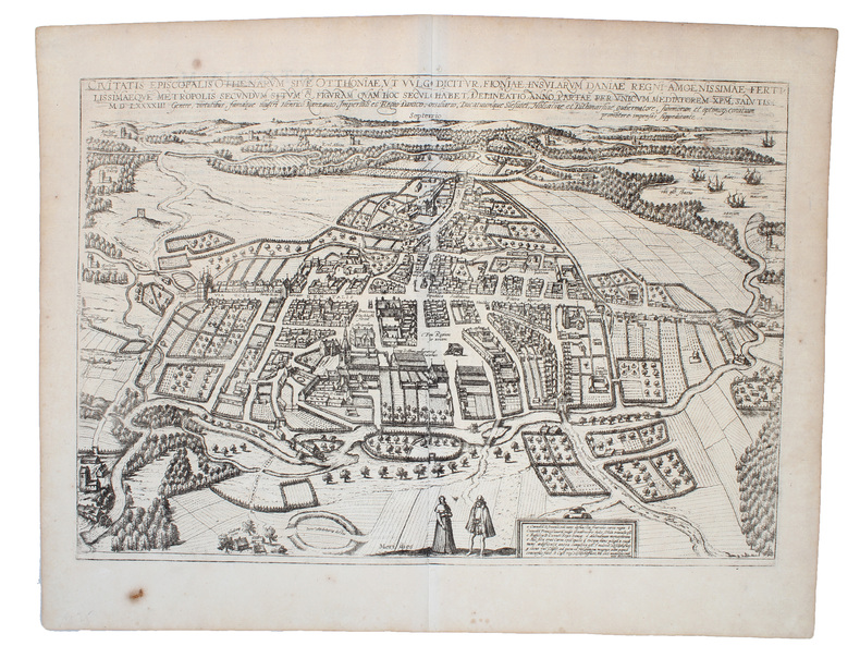
"ODENSE - BRAUN & HOGENBERG.
Civitatis Episcopalis Othenarum sive Otthoniæ, ut vulgo dicitur Fioniae Insularum Daniæ Regni...(Köln, 1593).
Kobberstukket prospekt over Odense visende byen i fugleperspektiv. 32,5 x 47,5 cm. Nogle få brunpletter, mest i de brede marginer, ellers fin stand.
书商的参考编号 : 19353
|
|
|
"ODENSE - BRAUN & HOGENBERG.
Civitatis Episcopalis Othenarum sive Otthoniæ, ut vulgo dicitur Fioniae Insularum Daniæ Regni.
(Köln, 1593). Kobberstukket prospekt over Odense visende byen i fugleperspektiv. 32,5 x 47,5 cm. Prospektet er i fin stand og i samtidig håndkolorering og indrammet under glas i en smuk ældre guldramme (49 x 62 cm.).
书商的参考编号 : 55185
|
|
|
"ODENSE - BRAUN & HOGENBERG.
Civitatis Episcopalis Othenarum sive Otthoniæ, ut vulgo dicitur Fioniae Insularum Daniæ Regni...(Köln, 1593).
Kobberstukket prospekt over Odense visende byen i fugleperspektiv. 32,5 x 47,5 cm. Nogle få brunpletter, mest i de brede marginer, ellers fin stand.
|
|
|
"ODENSE - BRAUN & HOGENBERG.
Civitatis Episcopalis Othenarum sive Otthoniæ, ut vulgo dicitur Fioniae Insularum Daniæ Regni.
(Köln, 1593). Kobberstukket prospekt over Odense visende byen i fugleperspektiv. 32,5 x 47,5 cm. Prospektet er i fin stand og i samtidig håndkolorering og indrammet under glas i en smuk ældre guldramme (49 x 62 cm.).
|
|
|
"ODENSE - PONTOPPIDAN, ERIK.
Odense.
(københavn, 1767). Kobberstukket grundplan af Odense. (20,7x33 cm.). På skrivepapir.
书商的参考编号 : 34619
|
|
|
"ODENSE - PONTOPPIDAN, ERIK.
Odense.
(København, 1767). Kobberstukket prospekt af Odense. (16,7x25 cm.). Stukket af A. Lode. På skrivepapir.
书商的参考编号 : 34618
|
|
|
"ODENSE - PONTOPPIDAN, ERIK.
Odense.
(København, 1767). Kobberstukket prospekt af Odense. (16,7x25 cm.). Stukket af A. Lode. På skrivepapir.
|
|
|
"ODENSE - PONTOPPIDAN, ERIK.
Odense.
(københavn, 1767). Kobberstukket grundplan af Odense. (20,7x33 cm.). På skrivepapir.
|
|
|
"ORTELIUS, A. - MAP OF FRANCE.
Galliae Regni Potentiss: Nova Descriptio Ioanne Ioliveto Auctore.
(Antwerpen, between 1584 a. 1612). 35x51 cm. Engraved map of France in fine contemporary handcolouring. Framed so that verso is shown. Latin text on verso ""Gallia"" with the initial Q handcoloured.
书商的参考编号 : 30762
|
|
|
"ORTELIUS, A. - MAP OF FRANCE.
Galliae Regni Potentiss: Nova Descriptio Ioanne Ioliveto Auctore.
(Antwerpen, between 1584 a. 1612). 35x51 cm. Engraved map of France in fine contemporary handcolouring. Framed so that verso is shown. Latin text on verso ""Gallia"" with the initial Q handcoloured.
|
|
|
"PARIS - PHILIPPE BUACHE.
Exposé d'un Plan hydrographique de la Ville de Paris.
(Paris, L'Imprimerie Royale, 1745). 4to. Without wrappers. Extracted from ""Mémoires de l'Academie des Sciences. Année 1742"". Pp. 371-378 and 3 folded engraved maps (1. Premier Plan Cours de la Seine dans l'etendue de Paris (20x23 cm) - 2. Second Plan ou l'on voit les Rues dont on à les pentes....les diverses Quartiers de Paris (19,5x22 cm) - 3. Coupe de la Ville de Pars... Plan des Rues... (22,5x30 cm)). Clean and fine.
书商的参考编号 : 46589
|
|
|
"PARIS - PHILIPPE BUACHE.
Exposé d'un Plan hydrographique de la Ville de Paris.
(Paris, L'Imprimerie Royale, 1745). 4to. Without wrappers. Extracted from ""Mémoires de l'Academie des Sciences. Année 1742"". Pp. 371-378 and 3 folded engraved maps (1. Premier Plan Cours de la Seine dans l'etendue de Paris (20x23 cm) - 2. Second Plan ou l'on voit les Rues dont on à les pentes....les diverses Quartiers de Paris (19,5x22 cm) - 3. Coupe de la Ville de Pars... Plan des Rues... (22,5x30 cm)). Clean and fine.
|
|
|
"PERTHES, JUSTUS.
Atlas Général, composé de trente quatre Cartes coloriées et gravées sur Cuivre.
Gota, Justus Perthes, 1873. Large 8vo. Orig. hcalf, but nicely rebacked with buckram. Double-page title-page with ""Table des Matiéres"" and 34 double-page engraved maps with outline-colouring. 8Numb. 1-20 + a,b,c numb). Maps clean, some brownspots seen on verso of maps.
书商的参考编号 : 49323
|
|
|
"PERTHES, JUSTUS.
Atlas Général, composé de trente quatre Cartes coloriées et gravées sur Cuivre.
Gota, Justus Perthes, 1873. Large 8vo. Orig. hcalf, but nicely rebacked with buckram. Double-page title-page with ""Table des Matiéres"" and 34 double-page engraved maps with outline-colouring. 8Numb. 1-20 + a,b,c numb). Maps clean, some brownspots seen on verso of maps.
|
|
|
"PETERMANN, A. (HRSG.). - A WORLD OF EXPLORATORY EXPEDITIONS.
Mittheilugen aus Justus Perthe's Geographischer Anstalt über wichtige neue Erforschungen auf dem Gebiete der Geographie. (1.-) 20. Bd. (Lacking vol. 14 (1868) & 1870).
Gotha, Julius Perthes, 1855-1874. 4to. Bound in 18 contemp. hcalf, some wear to the first 10 vols., some a bit rubbed. Some scattered brownspots to the first volumes. Gilt spines. Wear to top of spines. With a huge amount of original maps, plates, profiles etc., lithographed and engraved, large and folded and mainly in colour. This set does not include the ""Ergänzungsbände"".
书商的参考编号 : 46629
|
|
|
"PETERMANN, A. (HRSG.). - A WORLD OF EXPLORATORY EXPEDITIONS.
Mittheilugen aus Justus Perthe's Geographischer Anstalt über wichtige neue Erforschungen auf dem Gebiete der Geographie. (1.-) 20. Bd. (Lacking vol. 14 (1868) & 1870).
Gotha, Julius Perthes, 1855-1874. 4to. Bound in 18 contemp. hcalf, some wear to the first 10 vols., some a bit rubbed. Some scattered brownspots to the first volumes. Gilt spines. Wear to top of spines. With a huge amount of original maps, plates, profiles etc., lithographed and engraved, large and folded and mainly in colour. This set does not include the ""Ergänzungsbände"".
|
|
|
"PORCACCHI DA CASTIGLIONE, THOMASO.
L'isole piu famose del Mondo. Arettino e intagliate da Girolamo Porro Padovano. Con l'aggiunta di molte isole all' ill.re s. conte Georgio Trivltio. - [THE CULMINATION OF THE ""BOOK OF ISLANDS""]
Venetia [Venice], apresso gli heredi di S. Gagliani, 1590. [Colophon: In Vintia, appresso Giorgio Angelieri, a instantia de gli heredi di Simon Gagliani de Karera, 1590]. Small folio. 18th century (ab. 1780-90) half vellum with gilt leather title label to spine. Corners a bit bumped and title label a bit worn, otherwise nice and tight. A very nice copy, on thick, crisp paper. A few quires browned and brownspotted, and some occasional lighter browning. Four leaves with a marginal worm-tract, far from affecting text. Beautiful engraved title-page, consisting of a wide architectural border illustrated with large figures, putti, globes, and various symbols. Beautiful large woodcut initials and head- and tail-pieces. 47 half-page engraved maps in the text (by Porro, of islands and continents), excellent, crisp impressions. Large woodcut device to colophon. (12) ff., 201, (1) pp.
书商的参考编号 : 47728
|
|
|
"PORCACCHI DA CASTIGLIONE, THOMASO.
L'isole piu famose del Mondo. Arettino e intagliate da Girolamo Porro Padovano. Con l'aggiunta di molte isole all' ill.re s. conte Georgio Trivltio. - [THE CULMINATION OF THE ""BOOK OF ISLANDS""]
Venetia [Venice], apresso gli heredi di S. Gagliani, 1590. [Colophon: In Vintia, appresso Giorgio Angelieri, a instantia de gli heredi di Simon Gagliani de Karera, 1590]. Small folio. 18th century (ab. 1780-90) half vellum with gilt leather title label to spine. Corners a bit bumped and title label a bit worn, otherwise nice and tight. A very nice copy, on thick, crisp paper. A few quires browned and brownspotted, and some occasional lighter browning. Four leaves with a marginal worm-tract, far from affecting text. Beautiful engraved title-page, consisting of a wide architectural border illustrated with large figures, putti, globes, and various symbols. Beautiful large woodcut initials and head- and tail-pieces. 47 half-page engraved maps in the text (by Porro, of islands and continents), excellent, crisp impressions. Large woodcut device to colophon. (12) ff., 201, (1) pp.
|
|
|
"PRÆSTØ - PONTOPPIDAN, ERIK.
Præstöe.
(København, 1767). Kobberstukket prospekt af Præstø. (17,5x27 cm.).
书商的参考编号 : 34554
|
|
|
"PRÆSTØ - PONTOPPIDAN, ERIK.
Præstöe.
(København, 1767). Kobberstukket prospekt af Præstø. (17,5x27 cm.).
|
|
|
"RIETER & SENN.
Tvende Siællandske Bønder nærvejs Kiøbenhavn og Kiøgekanten i deres almindelige Dragt.
(København, 1805). Originalt håndkoloreret kobberstik. (21 x 14,5 cm.). Indrammet i ""sølvramme"" (29 x 21 cm.). Frisk eksemplar.
书商的参考编号 : 52215
|
|
|
"RIETER & SENN.
Tvende Siællandske Bønder nærvejs Kiøbenhavn og Kiøgekanten i deres almindelige Dragt.
(København, 1805). Originalt håndkoloreret kobberstik. (21 x 14,5 cm.). Indrammet i ""sølvramme"" (29 x 21 cm.). Frisk eksemplar.
|
|
|
"RINGSTED - PONTOPPIDAN, ERIK.
Ringsted.
(København, 1769). Kobberstukket prospekt af Ringsted. (17x25,5 cm.). Frisk eksemplar trykt på skrivepapir.
书商的参考编号 : 34552
|
|
|
"RINGSTED - PONTOPPIDAN, ERIK.
Ringsted.
(København, 1769). Kobberstukket prospekt af Ringsted. (17x25,5 cm.). Frisk eksemplar trykt på skrivepapir.
|
|
|
"ROSKILDE - PONTOPPIDAN, ERIK.
Roeskild.
(København, 1764). Kobberstukket prospekt af Roskilde. (17x24,5 cm.). Stukket af J. Haas. På skrivepapir. Lidt marginale brunpletter.
书商的参考编号 : 53312
|
|
|
"ROSKILDE - PONTOPPIDAN, ERIK.
Roeskild.
(København, 1764). Kobberstukket prospekt af Roskilde. (17x24,5 cm.). Stukket af J. Haas. På skrivepapir. Lidt marginale brunpletter.
|
|
|
"ROSKILDE DOMKIRKE - PONTOPPIDAN, ERIK.
Roeskilde Dom Kirke.
(København, 1764). Kobberstukket prospekt af kirken med omliggende ejendomme og begravelsesoptog foran. (17x24,5 cm.). Stukket af J. Haas. På skrivepapir. Lidt marginale brunpletter.
书商的参考编号 : 53311
|
|
|
"ROSKILDE DOMKIRKE - PONTOPPIDAN, ERIK.
Roeskilde Dom Kirke.
(København, 1764). Kobberstukket prospekt af kirken med omliggende ejendomme og begravelsesoptog foran. (17x24,5 cm.). Stukket af J. Haas. På skrivepapir. Lidt marginale brunpletter.
|
|
|
"RUGE, SOPHUS.
Die Entwicklung der Karthographie von Amerika bis 1570. Festschrift zur 400jährigen Feier der Entdeckung Amerikas. Mit 32 Kärtchen auf 2 Tafeln.
Gotha, Julius Perthes, 1892. 4to. No wrappers. (4),85 pp. and 32 maps on 2 large folded plates.
书商的参考编号 : 46766
|
|
|
"RUGE, SOPHUS.
Die Entwicklung der Karthographie von Amerika bis 1570. Festschrift zur 400jährigen Feier der Entdeckung Amerikas. Mit 32 Kärtchen auf 2 Tafeln.
Gotha, Julius Perthes, 1892. 4to. No wrappers. (4),85 pp. and 32 maps on 2 large folded plates.
|
|
|
"SAKSKØBING - PONTOPPIDAN, ERIK.
Saxkiøbing at see fra den Söndre Side.
(København, 1767). Kobberstukket prospekt af Sakskøbing. (17,8x25,5 cm.). Stukket af J. Haas efter tegning af I. Bang. Frisk eksemplar på skrivepapir.
书商的参考编号 : 34550
|
|
|
"SAKSKØBING - PONTOPPIDAN, ERIK.
Saxkiøbing at see fra den Söndre Side.
(København, 1767). Kobberstukket prospekt af Sakskøbing. (17,8x25,5 cm.). Stukket af J. Haas efter tegning af I. Bang. Frisk eksemplar på skrivepapir.
|
|
|
"SCHLESWIG-HOLSTEIN - HONDIUS, HENDRIK.
Ducatus Holsatiæ Nova Tabula. Amsterdam, (ca. 1630).
Kobberstukket kort over Slesvig og Holsten i samtidig håndkolorering. 38,5 x 51,5 cm. Med 2 kompasroser, skib i Nordsøen og 2 indsatte særkort i øverste hjørner. På bagsiden fransk tekst.
书商的参考编号 : 19351
|
|
|
"SCHLESWIG-HOLSTEIN - HONDIUS, HENDRIK.
Ducatus Holsatiæ Nova Tabula. Amsterdam, (ca. 1630).
Kobberstukket kort over Slesvig og Holsten i samtidig håndkolorering. 38,5 x 51,5 cm. Med 2 kompasroser, skib i Nordsøen og 2 indsatte særkort i øverste hjørner. På bagsiden fransk tekst.
|
|
|
"SCOTLAND - MERCATOR, G.
Scotiae Regnum. (Verso: Scotiae II. Tabula. In qua sequentes, Comitatus, Vicecomitatus & uniuersitates...).
(Duisburg, 1595). 35x44,5 cm. Engraved map of the Northern part of Scotland from 58-61',20''North, showing Orkney Island, hebrides and Skye. Fine orig. handcolouring.
书商的参考编号 : 25266
|
|
|
"SCOTLAND - MERCATOR, G.
Scotiae Regnum. (Verso: Scotiae II. Tabula. In qua sequentes, Comitatus, Vicecomitatus & uniuersitates...).
(Duisburg, 1595). 35x44,5 cm. Engraved map of the Northern part of Scotland from 58-61',20''North, showing Orkney Island, hebrides and Skye. Fine orig. handcolouring.
|
|
|
"SEUTTER, GEORG MATTHÄUS. - SCANDINAVIA AND THE BALTIC.
Synopsis Plagae septemtrionalis sive Sueciae Daniae et Norvegiae Regn.
(Wien, ca. 1730) (49x58,5 cm.). Kobberstukket, håndkoloreet Skandinavienskort med Estland, Letland, Litauen og det vestlige Rusland. Velbevaret indrammet under glas i fin ramme af brun birketræsfiner. Håndkolorereingen en smule svag.
书商的参考编号 : 49794
|
|
|
"SEUTTER, GEORG MATTHÄUS. - SCANDINAVIA AND THE BALTIC.
Synopsis Plagae septemtrionalis sive Sueciae Daniae et Norvegiae Regn.
(Wien, ca. 1730) (49x58,5 cm.). Kobberstukket, håndkoloreet Skandinavienskort med Estland, Letland, Litauen og det vestlige Rusland. Velbevaret indrammet under glas i fin ramme af brun birketræsfiner. Håndkolorereingen en smule svag.
|
|
|
"SLANGERUP - PONTOPPIDAN, ERIK.
Slangerup.
(København, 1764). Kobberstukket prospekt af Slangerup. (17x25 cm.). Fint frisk eksemplar trykt på skrivepapir.
书商的参考编号 : 34546
|
|
|
"SLANGERUP - PONTOPPIDAN, ERIK.
Slangerup.
(København, 1764). Kobberstukket prospekt af Slangerup. (17x24,5 cm.). Stukket af J. Haas. På skrivepapir. Lidt marginale brunpletter.
书商的参考编号 : 53310
|
|
|
"SLANGERUP - PONTOPPIDAN, ERIK.
Slangerup.
(København, 1764). Kobberstukket prospekt af Slangerup. (17x25 cm.). Fint frisk eksemplar trykt på skrivepapir.
|
|
|
"SLANGERUP - PONTOPPIDAN, ERIK.
Slangerup.
(København, 1764). Kobberstukket prospekt af Slangerup. (17x24,5 cm.). Stukket af J. Haas. På skrivepapir. Lidt marginale brunpletter.
|
|
|
"SOPHIENBORG - PONTOPPIDAN, ERIK.
Sophienborg.
(København, 1764). Kobberstukket prospekt af slottet. (17x24,5 cm.). Stukket af J. Haas. På skrivepapir. Lidt marginale brunpletter.
书商的参考编号 : 53316
|
|
|
"SOPHIENBORG - PONTOPPIDAN, ERIK.
Sophienborg.
(København, 1764). Kobberstukket prospekt af slottet. (17x24,5 cm.). Stukket af J. Haas. På skrivepapir. Lidt marginale brunpletter.
|
|
 ?????????
 ?????PDF???
 RSS feed


