|
Kane, Robert S.
AFRICA A TO Z. A Guide For Travelers - Armchair and Actual. Maps by Louise E. Jefferson. Photographs by the author. Foreword by John W. Houser, Vice-President, American Express Company.
408p. + Plus photographs. Full page text maps. Map endpapers. 8vo. Original full cloth binding. Original dust jacket. AFRICA/3
|
|
|
KAPLAN George G.
MERVEILLES DE LA PRESTIDIGITATION (LES)
Ed. Payot, Paris, 1971, broché, couverture illustrée, 316 illustrations de Francis J. Rigney, 324 pages, 14x22.5
书商的参考编号 : BLG00015

|
|
|
Karl & Faber
Konvolut Auktionskataloge in 10 Bänden. Vorhanden sind: Auktion 93, 97/I u. II, 115, 127, 132, 134, 135, 138, 138, 173.
München 1964 - 1987. 4°, jeder Katalog mit umfanreichem, tls. farb. Bildmaterial, OKart., Gebrauchsspuren, Stellspuren.
书商的参考编号 : EEzz7065(2KLV
|
|
|
Karl Baedeker with 44 Maps & 24 Plans with Yellow Endpaper Listing Beadeker's Guide Books Thru Manual of Conversation Unside
Baedeker's The Rhine from Rotterdam to Constance Handbook for Travellers 1896 Thirteenth Revised Edition Wtih Fold Out Map with Pencil Mark "handbook for Travellers"
Leipsic: Karl Baedeker Publ London 1896. Hardback NODustJacket 1896 Stated 13th Revised Edition NF-/VG- AS-IS NOJACKET Outer pgs edges Beautiful Marblelized Interior nice tight clean light wear FOX Small Red Cloth Embossed Cover Titled in Gold Gilt Cvr light wear rub Tiny Tears Bottom SpineCvr 4 1/4 X 6 1/4 in. 422 pgs Index .includes Color Maps Edge tears to Flyleaf . Hard Cover. Leipsic: Karl Baedeker Publ, London hardcover
书商的参考编号 : 25595
|
|
|
Karoly Szelenyi
Eger Heves County
No marks or inscriptions. A lovely clean very tight copy with bright unmarked white cloth gilt embossed boards and no bumping to corners. Dust jacket not price clipped or marked or torn or creased. Unpaginated ca 110pp. Culture, travel and history of the city of Eger in Heves County in Hungary. With 143 coloured plates. Scarce.

|
|
|
Karoly Szelenyi
Tokaj: Countryside in Changing Light
No marks or inscriptions to contents. A very clean very tight copy with bright unmarked boards with fainly intented rear and no bumping to corners. Dust jacket not price clipped or marked or torn or creased with faintly indented rear. Unpaginated pp. A pictorial account of the Hungarian regions of Bodrogkoz, Hegyalja, Hegykos and the Tokaj Hills. Almost all text in English, a little in Hungarian. With 136 colour plates, many full or double page. Scarce in the UK.

|
|
|
Karto & Grafik Hildebrand's Maps
"Mauritius ; Reunion"
2000-04-01. Good. Ships with Tracking Number! INTERNATIONAL WORLDWIDE Shipping available. May not contain Access Codes or Supplements. May be re-issue. May be ex-library. Shipping & Handling by region. Buy with confidence excellent customer service! unknown
书商的参考编号 : 3889892876 ???????? : 3889892876 9783889892874

|
|
|
Karto & Grafik Hildebrand's Maps
"USA ; l'est/the east"
2000-05-21. Good. Ships with Tracking Number! INTERNATIONAL WORLDWIDE Shipping available. May not contain Access Codes or Supplements. May be re-issue. May be ex-library. Shipping & Handling by region. Buy with confidence excellent customer service! unknown
书商的参考编号 : 3889892809 ???????? : 3889892809 9783889892805

|
|
|
Karto & Grafik Hildebrand's Maps
Canada Ouest
2000-05-01. New. Ships with Tracking Number! INTERNATIONAL WORLDWIDE Shipping available. May be re-issue. Buy with confidence excellent customer service! unknown
书商的参考编号 : 3889892787n ???????? : 3889892787 9783889892782
|
|
|
Karto & Grafik Hildebrand's Maps
Florida Map Hildebrand's USA Maps
2000-08-01. Good. Ships with Tracking Number! INTERNATIONAL WORLDWIDE Shipping available. May not contain Access Codes or Supplements. May be re-issue. May be ex-library. Shipping & Handling by region. Buy with confidence excellent customer service! unknown
书商的参考编号 : 3889891764 ???????? : 3889891764 9783889891761

|
|
|
Karto & Grafik Hildebrand's Maps
grande canarie
2002-01-07. Good. Ships with Tracking Number! INTERNATIONAL WORLDWIDE Shipping available. May not contain Access Codes or Supplements. May be re-issue. May be ex-library. Shipping & Handling by region. Buy with confidence excellent customer service! unknown
书商的参考编号 : 3889893015 ???????? : 3889893015 9783889893017

|
|
|
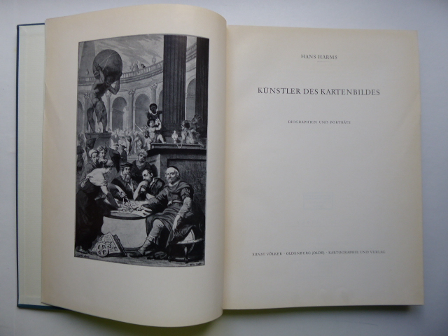
Kartographen - Harms, Hans
Künstler des Kartenbildes. Biographien und Porträts.
Oldenburg Ernst Völker Kartographie und Verlag 1962. 245, (1) Seiten. Mit sehr zahlreichen ganzseitigen Porträbildern u. 13 Kartenabbildungen im Text. Blauer, titelvergoldeter Original-Leinwand-Einband. (Bibliotheks-Exemplar mit Gebrauchsspuren). 28x21 cm
书商的参考编号 : 147381
|
|
|
KATTEGAT OG SUNDET - DECRES, C. (DENIS DUC DE DECRES).
Carte réduite du Cattegat comprenant La Côte de Suede depuis Marstrand jusqu'a Landscrone. La côte du Jutland depuis le Cap Skagen jusqu'à l'Entrée des Belts a la Cô septentrionale de l'Ile de Séelande d'apres les Observations et les Cartes Danoi...
(Paris), Au Depot général dee la Marine, 1813. 85x59 cm. Kobberstukket kort i stort format over Kattegat og den nordlige del af Øresund med København i syd, den svenske vestkyst fra Tjørnø i nord til Barsebæk i syd. Jyllands østkyst fra Skagen i nord til Gylling Næs i syd med øerne Anholt, Læsø, Samsø, Endelave m.v. Lidt rifter i højre marginsom ikke når bileldfladen. Fint rent eksemplar.
书商的参考编号 : 47340
|
|
|
KATTEGAT OG BÆLTERNE - J. ROBIJN (JACOB ROBYN).
Pascaert Vant Schager-Rack en de Belt. van d'Paternoster tetin de Oest Zee. Op Nieuws Verbetert door J. Robyn.
(Amsterdam), 1696. 52x59,5 cm. Kobberstukket og håndkoloreret søkort visende Bælterne mellem Østjylland, Fyn, Sjælland, Lolland og Falster, Sydsverige, Rü Bornholm, Nordtyskland m.v. Med det danske rigsvåben i nederste højre hjørne" heri dedikation til Cornelis Tromp, den danske og hollandske flådes admiral. Den store kartouche i øverste venstre hjørne viser scener fra folkelivet og brydning af kalksten fra Møn eller Stevns. Fin reparation i højre margin.
书商的参考编号 : 47333

|
|
|
Katharine Illustrated by Photo's and Maps Savage
The Story of the Common Market
Henry Z. Walck 1970. Hardcover. Good. Text in clean/unmarked condition. Former library copy with usual stickers. DJ shows wear. Binding is tight. Your Satisfaction Guaranteed. We ship daily. Expedited shipping available. Henry Z. Walck hardcover
书商的参考编号 : D2H0024076
|
|
|
KATTEGAT OG BÆLTERNE - J. ROBIJN (JACOB ROBYN).
Pascaert Vant Schager-Rack en de Belt. van d'Paternoster tetin de Oest Zee. Op Nieuws Verbetert door J. Robyn.
(Amsterdam), 1696. 52x59,5 cm. Kobberstukket og håndkoloreret søkort visende Bælterne mellem Østjylland, Fyn, Sjælland, Lolland og Falster, Sydsverige, Rü Bornholm, Nordtyskland m.v. Med det danske rigsvåben i nederste højre hjørne " heri dedikation til Cornelis Tromp, den danske og hollandske flådes admiral. Den store kartouche i øverste venstre hjørne viser scener fra folkelivet og brydning af kalksten fra Møn eller Stevns. Fin reparation i højre margin.
|
|
|
KATTEGAT OG SUNDET - DECRES, C. (DENIS DUC DE DECRES).
Carte réduite du Cattegat comprenant La Côte de Suede depuis Marstrand jusqu'a Landscrone. La côte du Jutland depuis le Cap Skagen jusqu'à l'Entrée des Belts a la Cô septentrionale de l'Ile de Séelande d'apres les Observations et les Cartes Danoi...
(Paris), Au Depot général dee la Marine, 1813. 85x59 cm. Kobberstukket kort i stort format over Kattegat og den nordlige del af Øresund med København i syd, den svenske vestkyst fra Tjørnø i nord til Barsebæk i syd. Jyllands østkyst fra Skagen i nord til Gylling Næs i syd med øerne Anholt, Læsø, Samsø, Endelave m.v. Lidt rifter i højre marginsom ikke når bileldfladen. Fint rent eksemplar.
|
|
|
Kavanagh, Martin
The Assiniboine Basin - A Social Study of Discovery, Exploration and Settlement: With Many Illustrations and Maps
282 pages. Index. Black and white photographic plates. Two fold-out maps. "The author has selected Brandon, a typical Assinniboine basin city, to illustrate civic development on the prairies." - from Preface. Prior owner's name and date upon front free endpaper. Binding intact. Average wear. A sound copy of this informative work. Peel (2nd Edn) 3990. Book

|
|
|
Kay-Robinson, Denys
The Landscape of Thomas Hardy
No marks or inscriptions. A very clean very tight copy with bright unmarked boards, very minor traces of foxing to page edges and no bumping to corners. Dust jacket not price clipped or marked or creased with one cm enclosed tear to spine and rubbing to top of spine. 240pp. This book takes the reader through the geographical area of Thomas Hardy's novels region by region, pointing out the association of each place in its geographical order.

|
|
|
Kazantzis, B.
Greece : The Land for All Seasons
No marks or inscriptions. Slight creasing to covers. A very clean very tight copy with bright unmarked very slightly foxed boards and no bumping to corners. 42pp. Tourist brochure on Greece in the early 1970s. Well illustrated.

|
|
|
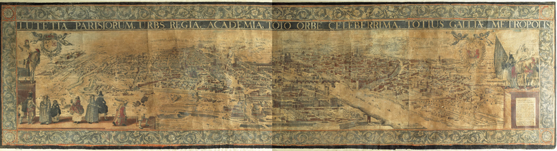
KEERE (Pieter van den) & HOEY (François van).
Lutetia Parisiorum urbs regia Academia toto orbe celeberrima totius Galliae metropolis.
[Amsterdam, 1617]. En quatre feuilles jointes de 590 x 2240 mm ; encadré sous verre.
书商的参考编号 : LBW-982
|
|
|
Kee Wayne; Maps and Illustrations Illustrator
Eastern Oregon Books and Print Volume II: An Annotated Historical Bibliography with some emphasis on maps
Paunina Press 2005-01-01. Paperback. Very Good. Text and images are clean and unmarked. Illustrated wrapper shows only a trace of use. Paunina Press paperback
书商的参考编号 : CHAPKEE12117 ???????? : 0971465312 9780971465312
|
|
|
Keegan, John & Wheatcroft, Andrew
Zones of conflict : an atlas of future wars
158pp. 25 cm. Hardcover Very good condition good
|
|
|
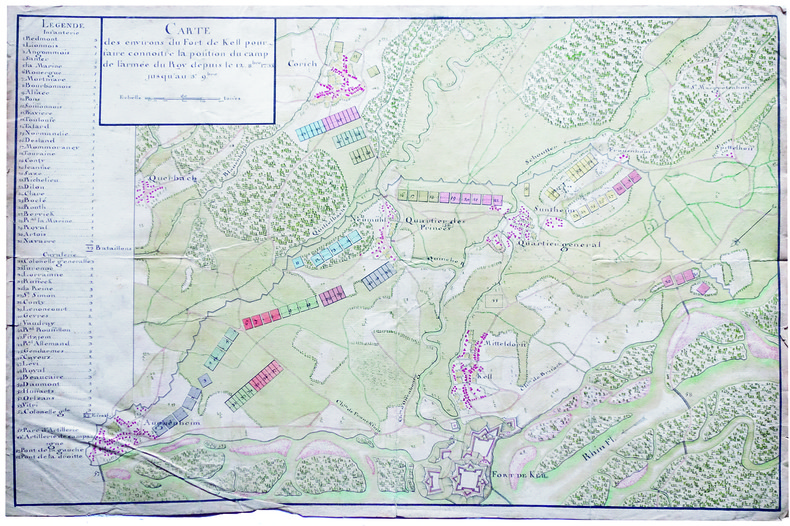
KEHL. MANUSCRIT.
Carte des environs du fort de Kell pour faire connoitre la position du camp de l'armée du roy depuis le 12 8.bre 1733 jusqu'au 3e 9.bre.
1733. 357 x 545 mm.
书商的参考编号 : LBW-4135
|
|
|
KELLER (François-Antoine-Édouard).
[ANTILLES] Carte de la partie des Antilles comprise entre la Martinique et S.t Christophe.
[Paris], Dépôt Général de la Marine, 1843. 901 x 602 mm.
书商的参考编号 : LBW-8308

|
|
|
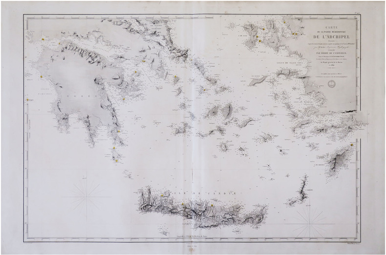
KELLER (François-Antoine-Édouard).
[MER ÉGÉE/CYCLADES] Carte de la partie méridionale de l'archipel.
[Paris], Dépôt-Général de la Marine, 1854-1864. 591 x 880 mm.
书商的参考编号 : LBW-8307
|
|
|
KELLER (Heinrich).
Panorama vom Rigiberg gezeichnet von Heinrich Keller.
Zürich, chez l'auteur, 1827. En deux feuilles jointes de 188 x 964 mm, monté en accordéon dans un cartonnage de papier rose, étiquette contenant la liste des autres vues et panoramas de l'auteur contrecollée sur le second contreplat ; étui de papier gris avec titre en français.
书商的参考编号 : LBW-3213
|
|
|
Keller, Heinrich (1778-1862):
Panorama der Katze - Gebirgs-Kette von Zürich aus. - (II:) Darstellung der von Zürich aus sichtbaren Gebirge / Vue des Alpes prise depuis la ville de Zürich. - (III:) Höhen-Vergleichung der von Zürich aus sichtbaren Gebirge.
(Zürich, Füssli Komm., 1813). 3 Umrissradierungen. I: 150 x 17 cm. - II: 62 x 17 cm. - III: 37 x 12,5 cm.
书商的参考编号 : 715CG
|
|
|
Kelleher, D. L.
Ireland of the Welcomes
No marks or inscriptions. Creasing/rubbing to oversize parts of covers. A clean very tight copy with slightly dusty unmarked boards, dusty page edges and no bumping to corners. 144pp. Tourist guide to Ireland with some photographs. Undated ca 1930s.

|
|
|
Keller, Heinrich (1778-1862)
Panorama der Katze - Gebirgs-Kette von Zürich aus. - (II:) Darstellung der von Zürich aus sichtbaren Gebirge / Vue des Alpes prise depuis la ville de Zürich. - (III:) Höhen-Vergleichung der von Zürich aus sichtbaren Gebirge.
(Zürich, Füssli Komm., 1813). 3 Umrissradierungen. I: 150 x 17 cm. - II: 62 x 17 cm. - III: 37 x 12,5 cm. + Wichtig: Für unsere Kunden in der EU erfolgt der Versand alle 14 Tage verzollt ab Deutschland / Postbank-Konto in Deutschland vorhanden +
书商的参考编号 : 715CG
|
|
|
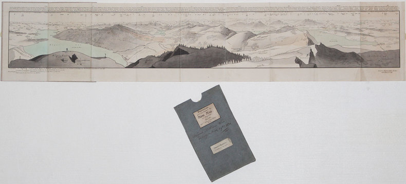
Keller, Heinrich.
Panorama prise au Sommet du Mont Rigi. Zurich, Keller & Füssli, (1816).
8vo. Fan-folded, hand-coloured aquatint (with 9 folding double leaves, c. 195 x 1980 mm) in contemporary blindstamped blue boards with floral design and mounted border. In slipcase with mounted title. The finest and rarest of Keller's panoramas in contemporary colour, depicting the view from Mount Rigi from Risch on Lake Zug to Kuessnacht on Lake Lucerne. Not to be confused with Keller's much more common like-titled panoramas of merely half size, published from 1820 onwards (cf. Harteveld Cat. 206, no. 123: their copy described as "splendidly coloured copy, then sold for the fourfold price of copies in simple colour"). In 1823 Keller was to publish yet another large-format panorama as part of a book with the same title, again not identical with this present view. - The title label bears the publisher note as quoted above; the view itself is captioned: "Gezeichnet auf dem Rigi-Kulm, 1814, von H. Keller, Vermehrt u. Berichtigt 1816 / gestochen von J. J. Scheurmann 1815". Two flaps (measuring 70 x 160 mm) can be folded out at the bottom, through with the view includes Arth on Lake Zug. Similarly, Mount Rossberg is also inserted as a flap, behind which the viewer may uncover Lake Aegeri and Eccehomo. Mounted on the back pastedown is a coloured engraving: "Le Mont Righi, dessiné près de Zoug" (175 x 107 mm; B. Bullinger del., F. Hegi sc.). - Minute paper defect on the horizon at far left, otherwise in perfect condition. Binding with occasional insignificant staining; altogether very clean. Insignificant bumping to edges of slipcase. Ms. ownership note by the Austrian actor Joseph Koberwein (1774-1857). The son of the important travelling actor Simon Friedrich Koberwein made his debut in 1796 at the Vienna Court Theatre and remained as a member of the ensemble until 1846. His principal roles were Ferdinand, Leicester, and Wallenstein. - Very rare; library and collection catalogues (OCLC, British Library, etc.) list only the later editions. Cf. Lonchamp 1672 (note). Barth 193787ff. (book edition only).

|
|
|
Kelly Joyce. Photographs by Jerry Kelly and by the Author. Drawings and Maps by the Author
Complete Visitor's Guide to Mesoamerican Ruins
Norman OK: University of Oklahoma Press 1982. Condition: VERY GOOD. 527 pp. b/w illus. Backstrip very lightly pulled at crown top edge a bit dusty. Lacks DJ. Size: 4to. 1st. Hardcover. Very Good/No Jacket. University of Oklahoma Press Hardcover
书商的参考编号 : 282089 ???????? : 0806115661 9780806115665

|
|
|
Kelter Edmund.
Eine Elbkarte des 16. Jahrhunderts im Museum für Hamburgische Geschichte.
Hamburg in Komm. bei Otto Meissner 1919. . Ecken etw. gestaucht sonst gut erhalten. - Möller/Tecke I 441. Hamburg, in Komm. bei Otto Meissner, 1919. unknown
书商的参考编号 : 18167
|
|
|
Kenney Rowland maps by JF. Horrabin J. F.
The Northern Tangle: Scandinavia and the Post-War World
London: J.M. Dent 1946. Hard bound 1st edition 255pp inc. index. Very good/-- no dust jacket London: J.M. Dent, 1946, unknown
书商的参考编号 : 5303
|
|
|
Keogh EG./Capper GM. maps E. G. G. M.
South West Pacific 1941-1945
Melbourne: Grayflower Productions 1965. 1st edition. VG/Good dust jacket short tears to edges of dust jacket. 12 483 p. maps footnotes appendices 8vo; Grayflower Productions hardcover
书商的参考编号 : 58017

|
|
|
Kepanga Mundiya Dozier Marc
L'étrange tribu des français
PLUME CAROTTE 2021 56 pages 23 5x23 5x1 2cm. 2021. Relié. 56 pages.
书商的参考编号 : 500048746

|
|
|
Kepanga Mundiya Dozier Marc
L'étrange tribu des français
PLUME CAROTTE 2021 56 pages 23 5x23 5x1 2cm. 2021. Relié. 56 pages.
书商的参考编号 : 500077126

|
|
|
Kepanga Mundiya Dozier Marc
L'étrange tribu des français
PLUME CAROTTE 2021 56 pages 23 5x23 5x1 2cm. 2021. Relié. 56 pages.
书商的参考编号 : 500078502

|
|
|
Kepanga Mundiya Dozier Marc
L'étrange tribu des français
PLUME CAROTTE 2021 56 pages 23 5x23 5x1 2cm. 2021. Relié. 56 pages.
书商的参考编号 : 500078507

|
|
|
Kepanga Mundiya Dozier Marc
L'étrange tribu des français
PLUME CAROTTE 2021 56 pages 23 5x23 5x1 2cm. 2021. Relié. 56 pages.
书商的参考编号 : 500084134

|
|
|
Kepanga Mundiya Dozier Marc
L'étrange tribu des français
PLUME CAROTTE 2021 56 pages 23 5x23 5x1 2cm. 2021. Relié. 56 pages.
书商的参考编号 : 500084135

|
|
|
Kepanga Mundiya Dozier Marc
L'étrange tribu des français
PLUME CAROTTE 2021 56 pages 23 5x23 5x1 2cm. 2021. Relié. 56 pages.
书商的参考编号 : 500092511

|
|
|
Kepanga Mundiya Dozier Marc
L'étrange tribu des français
PLUME CAROTTE 2021 56 pages 23 5x23 5x1 2cm. 2021. Relié. 56 pages.
书商的参考编号 : 500092512

|
|
|
Kep Maps Inc
Key Map Galveston Brazoria Atlas 5th Edition 2002
Key Maps Inc. Used - Good. Shows some signs of wear and may have some markings on the inside. Key Maps, Inc unknown
书商的参考编号 : GRP115538658 ???????? : 1885822316 9781885822314
|
|
|
KERMAINGANT, Mathurin François.
Mémoire sur le Projet d’un Chemin de Fer de Lyon à Marseille. Ministère des Travaux Publics de l’Agriculture et du Commerce. Direction Générale des Ponts et Chaussées et des Mines.
Paris, Imprimerie Royale, 1837. In-4 – 22,5 x 29 cm. Broché. 172 pages, 1 carte dépliante en 2 parties. Edition originale. Ouvrage complet de sa grande « Carte Générale des tracés du Chemin de Fer de Lyon à Marseille » très détaillée (150 x 57cm). On découvre le tracé proposé sur la rive droite du Rhône, rehaussé en vert, et celui sur la rive gauche du Rhône, rehaussé en rouge, les deux se rejoignant à Tarascon puis poursuivant par Arles et les Martigues. Un tracé alternatif de la rive gauche, rehaussé en jaune, entre la Durance et Marseille, envisage une bifurcation à partir d’Avignon en passant par Orgon, Salon, Aix, Fuveau, Aubagne et la vallée de l’Huveaune. Mathurin François Kermaingant (1779-1856) est un ingénieur originaire du Nord de la France. Il intègre l'école des Ponts et Chaussées en 1800. Quatre ans plus tard, il est affecté au service de route de la Drôme. Il quitte ce département pour celui du Rhône en 1810, puis y revient en 1821, pour 3 années. C'est dans la Sarthe qu'il poursuit sa carrière à partir de 1824. A la demande du gouvernement, il pilote la commission d'étude sur un futur chemin de fer dans la vallée du Rhône en 1833. Il suggère de nombreuses variantes de tracés. En 1836, il est nommé ingénieur en chef. Il quitte le sud de la France puis s'occupe du chemin de fer de Paris à Versailles.
书商的参考编号 : 2321

|
|
|
KEULEN (Gerard van).
[CORSE & SARDAIGNE] Nieuwe en nette afteekening van het eyland Corsica en het eyland Elba vertoonende alle desselfs havenen, steeden en rivieren - Nieuwe en nette afteekening van het eyland of Koninkryk Sardinia vertoonende alle desselfs zee havenen, anker, plaetsen, rivieren, dieptens, klippen, steeden en vastigheeden als mede de Straet van Bonifacio aent eyland Corsica.
Amsterdam, [1734]. En deux feuilles jointes formant une carte de 502 x 879 mm.
书商的参考编号 : LBW-8194

|
|
|
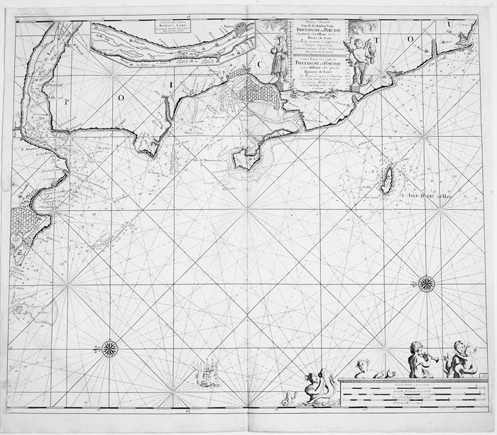
KEULEN (Johannes van);
Nieuwe pascaart van de zeekusten van Bretangne en Poictou.
Amsterdam circa 1700 494 x 583 mm.
书商的参考编号 : LBW-811
|
|
|
KEULEN (Johannes van);
Nieuwe pascaart van een gedeelte van Bretangne.
Amsterdam circa 1700 513 x 592 mm.
书商的参考编号 : LBW-814

|
|
|
KEULEN (Johannes van);
Pascaart van de zeekusten van Galissen.
Amsterdam circa 1700 511 x 588 mm.
书商的参考编号 : LBW-818

|
|
|
KEULEN (Johannes van).
Paskaart van Gallissien van C. de Finisterre tot aen Zurara.
Amsterdam, [circa 1700]. 505 x 567 mm.
书商的参考编号 : LBW-950

|
|
 ?????????
 ?????PDF???
 RSS feed


