|
Facsimile des Planes der Stadt Basel von Matthaeus Merian
Brochiertes Heft und Papiermappe. Basel 1894 Gr.-Folio. 1 Titelblatt, Uebersichtsplan, 9 farbige Tafeln und dem dazugehörenden Beiheft mit 19 S. Beiheft leicht fleckig. Papiermappe mit Einrissen. Mitteilungen der historischen und antiquarischen Gesellschaft zu Basel. Neue Folge IV.
書籍販売業者の参照番号
: 3000DB
|
|
|
Facsimile des Planes der Stadt Basel von Matthaeus Merian
Basel, 1894. Gr.-Folio. 1 Titelblatt, Uebersichtsplan, 9 farbige Tafeln und dem dazugehörenden Beiheft mit 19 S. Beiheft leicht fleckig. Papiermappe mit Einrissen. + Wichtig: Für unsere Kunden in der EU erfolgt der Versand alle 14 Tage verzollt ab Deutschland / Postbank-Konto in Deutschland vorhanden + Brochiertes Heft und Papiermappe. Mitteilungen der historischen und antiquarischen Gesellschaft zu Basel. Neue Folge IV.
書籍販売業者の参照番号
: 3000DB
|
|
|
Festschrift Eduard Dolezal zum neunzigsten Geburtstag gewidmet v. s. Freunden u. Schülern.
Wien, 1952. M. 1 Faks., 1 Portr., 2 Taf. u. zahlr. Abb. LXXXIV, 681 S. OKart. (Umschl. etwas fleckig, Stempel auf Umschl. u. erstem weißen Blatt). Mit einer Widmung von Lego an den Staatssekretär Bock.
書籍販売業者の参照番号
: 607023
|
|
|
Firenze - Siena. Planimetrie e profili ciclistici n.8
Cartina più volte ripiegata a fisarmonica; 22 x 104 cm. Ottima
|
|
|
FONS D'ART FUNDACIÓ CAIXA DE BARCELONA. COL·LECCIÓ CARTOGRÀFICA 1. Mapes - Barcelona 1986 - Il·lustrat
Barcelona, Edit. Caixa de Barcelona, 1986. Nombroses il·lustracions en color i b/n. 114 p. 8è. Rústica editorial il·lustrada una mica deslluïda. Bon exemplar.
|
|
|
Fossombrone - Gualdo Tadino. Planimetrie e profili ciclistici n. 19
Cartina più volte ripiegata a fisarmonica; 22 x 96 cm. Ottima
|
|
|
Frosinone - Ceprano - Capua. Planimetrie e profili ciclistici n. 24-25-26
Cartina più volte ripiegata a fisarmonica; 22 x 192 cm. Ottima
|
|
|
G. Mayr: Suedoestliche Schweiz, Sued-Tyrol, Lombardei und Venedig. Atlas de Alpenlaender, Blatt V.
Carta incisa di cm. 66 x 46. Applicata su tela e contenuta in leg. edit. in cartonato a stampa. Perfetta conservazione.

|
|
|
Genova e le due riviere fino a Nizza e Cannes e fino alla Spezia
16°, 16 cm, pp. 152, 32 incisioni e la pianta tipografica di Genova. Rilegatura editoriale in tela, titolo in oro al piatto e dorso, cornici a secco. Collana: Guide Treves, esemplare buono

|
|
|
Geodezja i Kartografia. Tom XVI Zes. 1.
Warzawa, 1967. M. mehr. Abb. 72 S. OBr. Umschlag leicht angeschmutzt u.m. mehr. St. Papier nachgedunkelt.
書籍販売業者の参照番号
: 199589
|
|
|
Geodezja zeszyt 53 plan kollatajowski Miasta Krakowa. Reprodukcje Planu ......del 1785.
carella in folio contenente 1 carta d'assieme e 24 fogli dettagliati dell'edzione del 1785 oltre ad un fascicolo di pp. 35. Cartella con segni del tempo e titolo al piatto.
|
|
|
GEOGRAFIA. Due incisioni originali in rame (cm 33x24,5) tratte da: ENCICLOPEDIA ITALIANA E DIZIONARIO ITALIANO DELLA CONVERSAZIONE.
(Codice OS/0182) Le 2 tavole sono ORIGINALI e provengono da un volume sciolto. Ottimo stato. ~~~ SPEDIZIONE IN ITALIA SEMPRE TRACCIATA

|
|
|
Geographia" main roads map of Scotland.
Carta a colori più volte ripiegata di cm. 95 X 71, con bross. edit. Ottima la conservazione.

|
|
|
Geotechnische Karte der Schweiz / Carte géotechnique de la Suisse / Carta geotechnica della Svizzera. N° 1 à 4. Ensemble 4 cartes dépl. en couleur / 4 kolor. gefalt. Karten. Hrsg. v.d. Geot. Komm. d. Schweiz. Naturf. Ges.
Bern, Kümmerly & Frey, (1935), ca. 72x125 par carte (gef. 24x13 cm), Echelle - Masstab - scala: 1:200.000 - Feuille - Blatt N° 1) Neuchâtel - Bern - Basel / 2) Luzern - Zürich - St. Gallen - Chur / 3) Genf - Lausanne - Sitten / 4) Bellinzona - St. Moritz. Orig.-Umschlag. 4 zusammen.
書籍販売業者の参照番号
: 128371aaf
|
|
|
Grafica antica e moderna. Catalogo n. 10: Antichi maestri - Importanti carte murali e cartografia tolemaica - Rare immagini di Milano - Viaggio dal lago di Como verso la Valtellina - Aerostatica - Grafica contemporanea.
Milano, Quattrifolio, novembre 1984, in-8, br., pp. 128, (2). Con numerose ill. in b.n. e prezzi di stima.
|
|
|
Grafschaft Henneberg, (1594). [Gerahmter altkolorierter Original-Kupferstich].
o.J.
書籍販売業者の参照番号
: 65648CB
|
|
|
Gran Carta degli Stati Sardi in Terraferma divisa in fogli 91 alla scala di 1/50,000. N. 25. S. Maurizio di Pallanza.
Carta topografica in litografia di cm. 73 x 54 ca. più volte ripiegate e contenuta entro cartella in piena tela edit. con fregi a secco ai piatti. Ben conservato. Importante cartografia edito da Corpo Reale di Stato Maggiore tra il 1852 e il 1870.
|
|
|
Gran Carta degli Stati Sardi in Terraferma divisa in fogli 91 alla scala di 1/50,000. N. 69 Monte Penna.
Carta topografica in litografia di cm. 73 x 54 ca. più volte ripiegate e contenuta entro cartella in piena tela edit. con fregi a secco ai piatti. Ben conservato. Importante cartografia edito da Corpo Reale di Stato Maggiore tra il 1852 e il 1870.
|
|
|
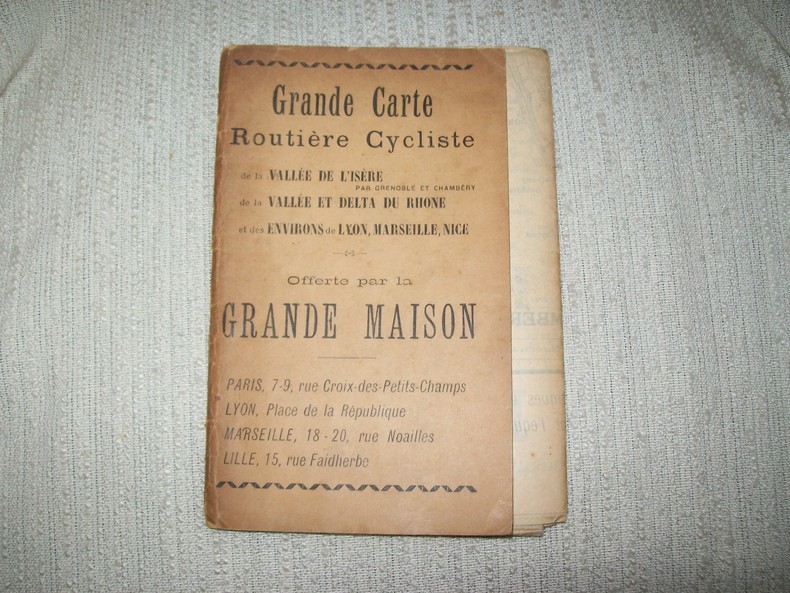
GRANDE CARTE ROUTIERE CYCLISTE de la Vallée de l'Isère par Grenoble et Chambéry, de la Vallée et du Delta du Rhône et des environs de Lyon, Marseille, Nice. Offert par la GRANDE MAISON.
Sans lieu ni date vers 1900. Grande carte dépliante bordée de publicités pour des vêtements de cyclistes 75cm sur 100cm bordure publicitaire comprise (19cm sur 13,5cm une fois pliée) sous couverture portant le titre sur le 1er plat et une publicité sur le 2e. Couverture légèrement poussiéreuse, coupure sans manque à la jonction carte-couverture, carte en bon état et bien complète.
書籍販売業者の参照番号
: GITg799
|
|
|
Grandi esercitazioni di Cavalleria (1906)
Carta a col. di cm. 80x52 ca., scala 1:100.000. Qq. rest. al verso, ma nel compl. discreto es.

|
|
|
Grandi mappe di città. oltre 70 capolavori che riflettono le aspirazioni e la storia dell'uomo. Ediz. illustrata
ill., ril. Le città sono centri di potere politico, economico, religioso e culturale e i mutamenti del tessuto urbano dimostrano la loro continua evoluzione e il loro adattamento a sfide nuove e spesso difficili. Dall'antica metropoli di Roma al primo nucleo di New York, dalla Londra del 1682 alla caotica Tokyo del 2014, questo libro illustrato esplora i centri urbani attraverso più di 70 piante di città e mappe storiche. Close-up, particolari e focus rivelano i dettagli nascosti e presentano le figure dei cartografi che hanno interpretato il mondo attraverso le loro opere.

|
|
|
Grosser JRO Weltatlas. Permanentausgabe. 4. Aufl.
München, JRO-Vlg. (1957). 2°. M. 21, 12, 17 farb. Ktn. LVI, 65, 40 S. In 1 geschraubten OLwd.-Hefter. M. Rsign. Rücken etwas angerissen. Kanten teils beschabt. Schmutztit. m. Knick.
書籍販売業者の参照番号
: 134428
|
|
|
Guida delle strade di grande comunicazione. Italia centrale
16°, 18 cm, pp. 358, alcune figure nel testo, una carta geografica ripiegata fuori testo, rilegatura editoriale in tela, titolo al piatto, esemplare molto buono

|
|
|
Guida turistica della provincia di Sondrio
16°, pp. 155, brossura editoriale, buono stato di conservazione. Numerose illustrazioni in bianco e nero con didascalia nel testo e fuori testo.

|
|
|
Guida turistica e cartografica delle provincie d'Italia.
Roma, ACI, 1980, volumi 3, in-8, cartone editoriale. pp. 202, 220, 173. Con numerose piante di città e vasta cartografia.
|
|
|
Guide pour la lecture des cartes marines étrangères.
P, Service hydrologique de la Marine , 1952 , in4° reliure éditeur, 230pp . Edition tapuscrite. 2ème édition . Langue: Français
書籍販売業者の参照番号
: M4996
|
|
|
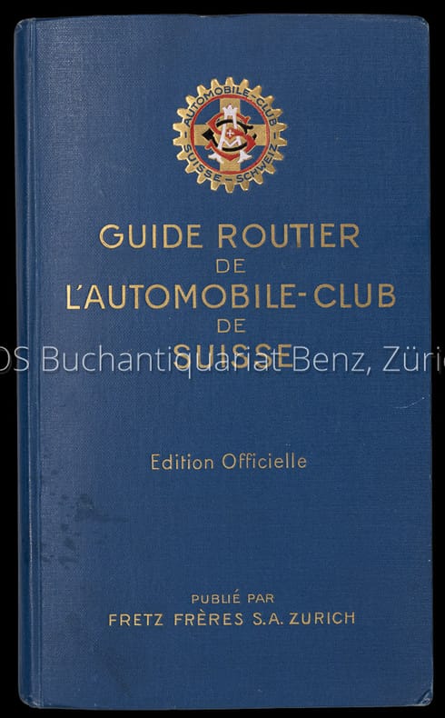
Guide routier de l'automobile-club de Suisse. Edition officielle.
Editeur Automobile Club de Suisse. Zürich, Fretz, 1924. 8°. 288 S. Mit zahlr. gef. Karten und Plänen. Illustr. Orig.-Leinenband.
書籍販売業者の参照番号
: 4114DB
|
|
|
Guide routier de l'automobile-club de Suisse. Edition officielle.
Zürich, Fretz, 1924. 8°. 288 S. Mit zahlr. gef. Karten und Plänen. Illustr. Orig.-Leinenband. + Wichtig: Für unsere Kunden in der EU erfolgt der Versand alle 14 Tage verzollt ab Deutschland / Postbank-Konto in Deutschland vorhanden +, A|B [2 Warenabbildungen] Editeur Automobile Club de Suisse.
書籍販売業者の参照番号
: 4114DB

|
|
|
Guide-Panorama of the Rhine from Mayence to Cologne.
Mainz, W. Suder, [ca. 1920]. Klein-8°. 24,5 x 11 cm. Original-Broschur. [2 Warenabbildungen]
書籍販売業者の参照番号
: 2101FB

|
|
|
Haack geographischer Atlas. 3. Aufl.
Gotha, Haack, (1982). M. zahlr. farb. Ktn. 336 S. OLwd.
書籍販売業者の参照番号
: 140166
|
|
|
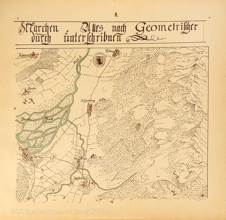
Hans Konrad Gyger's Züricher-Cantons-Carte 1667.
Zürich, Hofer & Burger, 1891. Quer.-folio. (7) Bl. Mit Frontisp., Übersichtskarte und 56 Karten (chromolithogr. Reproduktionen). Illustr. Orig.-Halbleinenband.
書籍販売業者の参照番号
: 7594CB
|
|
|
Hans Konrad Gyger's Züricher-Cantons-Carte 1667.
Zürich, Hofer & Burger, 1891. Quer.-folio. (7) Bl. Mit Frontisp., Übersichtskarte und 56 Karten (chromolithogr. Reproduktionen). Illustr. Orig.-Halbleinenband. + Wichtig: Für unsere Kunden in der EU erfolgt der Versand alle 14 Tage verzollt ab Deutschland / Postbank-Konto in Deutschland vorhanden +, 7594CB
書籍販売業者の参照番号
: 7594CB

|
|
|
Historisch-geographisches Kartenwerk. Britische Inseln, Frankreich, Belgien, Niederlande, Luxemburg. Wirtschaftshistor. Entwicklung. Bearb. v. W. Schmeer, R. Ogrissek u. H. Weiße.
Leipzig, Enzyklopädie, 1960. Fol. 28 Bl. m. farb. Ktn. u. 53 S. Text. In 1 Lwd.-Mappe. Diese leicht angestaubt.
書籍販売業者の参照番号
: 206327
|
|
|
Hundert Jahre Eidg. Landestopographie. Ehemaliges Eidg. Topographisches Bureau 1838 - 1938. Erinnerungsmappe.
Bern, Eidg. Landestopographie, 1938, in-4to, 3 Kartonmappen mit den einzeln gehefteten Beiträgen, zusammen ca. 200 S. mit sw. Textabb., 16 Tafel mit je 1 oder 2 montierten Kartenausschnitten. Kartomappe mit Schliessband. Neuwertig.
書籍販売業者の参照番号
: 92684aaf
|
|
|
Hungarian cartographical studies. Ed. by E. Csáti. 14th World Conference Intern. Cartogr. Association.
Budapest, 1989. 4°. M. 11 (10 farb.) Taf. u. zahlr. Abb. 2 Bl., III, 292 S.
書籍販売業者の参照番号
: 621948
|
|
|
I PAESI BALCANICI LA GRECIA - ed i limiti dell'Impero Ottomano in Europa nell'anno 1914
Volume in 8°. Cartellina verde contenente 1 carta geografica colori di dimensioni 63 x 70 cm. Scala 1:2.000.000. La carta geografica in ottime condizioni. La cartellina con bruniture dovute al tempo.

|
|
|
Il Friuli. La nostra casa. Ediz. illustrata
ill.
|
|
|
IL GRANDE ATLANTE DI SELEZIONE.
(Codice CU/4815) Folio (40x28 cm) 180 pp. Comprendente 68 pp. di carte a colori (di cui 8 relative all'Italia), 24 di carte tridimensionali, 44 di supplememto sulle config. terrestri, 30 pp. di indici geografici mondiali, con 25.000 nomi. Tela editoriale, titolo oro, ottimo stato. ~~~ SPEDIZIONE IN ITALIA SEMPRE TRACCIATA

|
|
|
IL TOURING CLUB ITALIANO NEI TRENT'ANNI DALLA SUA FONDAZIONE.
(Codice CU/8027) In 8° 4 pp. Interessanti notizie storiche illustrate con 4 foto du tavole fuori testo. Brossura originale. ~~~ SPEDIZIONE IN ITALIA SEMPRE TRACCIATA

|
|
|
Il viaggio in Europa di Pietro Guerrini ( 1682 - 1686 ) . Edizione della corrispondenza e dei disegni di un inviato di Cosimo III dei Medici.
Toscana, 1682: Cosimo III dei Medici fa compiere a un giovane architetto fiorentino un lungo viaggio attraverso l’Europa centro-settentrionale, per descrivere e disegnare, nei loro particolari tecnici, edifici, macchinari, sistemi per la regimazione e il Tuscany, 1682: Cosimo III dei Medici commissions a young Florentine architect to undertake a long journey across central northern Europe to make <br/> TITOLO: Il viaggio in Europa di Pietro Guerrini (1682-1686). Edizione della corrispondenza e dei disegni di un inviato di Cosimo III dei Medici. <br/> CURATORE: A cura di F. Martelli.<br/> EDITORE: Olschki Ed.<br/> DATA ED.: 2005,<br/> COLLANA: Coll. Documenti di storia italiana - Serie II, 11.<br/> EAN: 9788822254016

|
|
|
Il vicentino nelle mappe della Biblioteca Bertoliana. Storia e immagini del territorio dalla raccolta cartografica
317 p., molte ill. e carte a colori ripiegate n.t.; 30 cm. Cart. editoriale. Molto buono
|
|
|
Illustrated Wall Maps of the Bible / Atlas of the Bible: Index and Chronological Table [PORTFOLIO]
Contains CD. 36X26 cm. 17+unnumbered pages. Portfolio. Cover edges slightly chafed. Else in good condition. PLEASE NOTE: This item is overweight. We may ask for extra shipping costs.
|
|
|
IMAGO MUNDI. A review of early cartography, Stockholm
Leiden, Brill, 1953. (mm. 295). Cartonato editoriale. pp. (4), 152, (2) con molte tavole f.t. anche più volte ripiegate. Contiene: The north atlantic nautical chart of 1424; a circular map in Ptolemaic ms; The atlas of Angelo Freducci, 1556; The mural atlas of Caprarola; The map drawings of Aegidius Tschudi; Plan of Moscow Isaac Massa; terrestrial and celestial globes by V. Coronelli, 1688; the first maps of the Dnieper cataracts; the types of world map made in Japan age of national isolation; TWO gEORGIAN MAPS OF THE FIRST HALF OF THE EIGHTEENTH CENTURY
|
|
|
INSTRUCTION POUR LA LECTURE DES CARTES TOPOGRAPHIQUES
Paris Librairie Chapelot 1916 In-12 Broché Passable
書籍販売業者の参照番号
: 005230
|
|
|
Instruction pour la Lecture des Cartes topographiques
Paris, Librairie Militaire de L. Baudoin, 1894. 10e édition. In-12 broché bleu, viii-57 p. 27 figures in-t. Bon état : couv. un peu jaunie.
書籍販売業者の参照番号
: 16251
|
|
|
Instructions nautiques - France côtes Nord et Ouest - Planches
P, S H O Marine , 1972 , gr in8 en feuilles, reluire anneaux, Près de 200 planches. Langue: Français
書籍販売業者の参照番号
: M4993
|
|
|
Instrukcja opracowania mapy hydrograficznej Polski. 3., verb. Aufl.
Warszawa, Inst. Geogr. PAN, 1964. M. 11 Musterformularen u. 26 Abb. 85, 29 S. (Dokumentacja geograficzna 1964,3).
書籍販売業者の参照番号
: 636024
|
|
|
International yearbook of cartography. Jg. 12.
Gütersloh/Budapest, 1972. M. zahlr. Taf. u. Abb. OHlwd.
書籍販売業者の参照番号
: 621632
|
|
|
Istituto Geografico Militare/ Military Geografic Institute/ Institut Géographique Militaire - Sezione vendite (V.le F. Strozzi, 14). Catalogo delle pubblicazioni/ Catalog of publications/Catalogue des publications.
Firenze, 1967, in-8 formato album, cartoncino edit., pp. 45, (3). Con 20 tavv. (quadri d'unione della Carta d'Italia, carte aeronautiche, Libia-Eritrea-Somalia) e listino prezzi (cartografia e pubblicazioni in vendita) in fascicolo allegato di pp. 10.
|
|
|
ITINERARIO GENERALE DEGLI STATI DI S. M. SARDA IN TERRAFERMA AD USO DELLE AMMINISTRAZIONI CIVILI E MILITARI COMPILATO D'ORDINE DEL MINISTERO DI GUERRA DA APPOSITA COMMISSIONE. L'ANNO 1856.
In 4°(334x230), pagg. XVI, 509, 1 di errata. Con 39 carte f.t. (di cui 10 ripiegate), e una grande tavola ripiegata, posta alla fine del tomo, con lo "Specchio dimostrativo delle Strade Ferrate in esercizio, in costruzione e concesse nei Regii Stati con indicazione delle Stazioni e delle distanze fra le stesse". Mezza pelle coeva con titolo in oro al dorso. Tagli a spruzzo. Sono riportati gli itinerari che riguardano le provincie di: Acqui, Alba, Albenga, Albertvile, Alessandria, Annecy, Aosta, Asti, Biella, Bobbio, Boneville, Casale, Chambery, Chiavari, Cuneo, Domodossola, Genova, Ivrea, Mondovi', Mortara, Moutiers, Nizza, Novara, Novi, Oneglia, Pallanza, Pinerolo, Moriana, Saluzzo, San Remo, Savona, Levante, Susa, Chiablese (Thonon), Torino, Tortona, Valsesia (Varallo), Vercelli, Voghera. Alla fine vi sono tabelle dimostrative con l'elenco dei comuni, Popolazione dei Regi Stati di terraferma e la tav. Poliometrica generale. Bell'esemplare con carta lievemente brunita. Timbretto di collezione privata ripetuto al frontespizio, ed alle sguardie. <BR>
|
|
 検索結果のメールを受信する
 PDFファイルの検索結果をダウンロード
 RSSフィード


