|
|
|
GREGOIRE L.
Atlas de géographie physique et politique
In folio carré, demi-chagrin vert, titre, filets dorés, faux-titre, titre, II, 71 cartes sur double page montées sur onglets. Paris Garnier frères sans date
書籍販売業者の参照番号
: 11450

|
|
|
GREGOIRE
Atlas universel de Géographie physique & politique
Paris, Garnier frères, s. d. [entre 1883 et 1893] In-folio, demi-percaline brune, titre doré au dos. Bien complet des 80 cartes en couleurs de France, d'Europe et du monde, montées sur onglets, dont de nombreuses sur double page. Reliure usagée.
書籍販売業者の参照番号
: 5413
|
|
|
Grenet, professeur au collège de Lisieux
Atlas portatif à l’usage des collèges, pour servir à l’intelligence des auteurs classiques, dédié à l’université de Paris
Sans éditeur 1781 Les cartes sont dressées par M. Bonne, Ingénieur Hydrographe de la Marine. In-4, reliure, titre gravé en double page, 37 doubles cartes gravées montées sur onglets. et une planche 19e siècle contre collée. Reliure restaurée amateur, recouverte de papier kraft, gardes fragilisées annotations à l’encre d’époque et au crayon papier. Manque 7 cartes sur 44. Mouillures. Rousseurs.
書籍販売業者の参照番号
: 85108
|
|
|
Greta Milis - Proost
Inventaris der Kaarten en Globes
Gent, Rijksuniversiteit Gent, 1967 Softcover, 464 pag. NL. in zeer goede staat, 245 x 160 mm. geen illustraties. ISBN X.
書籍販売業者の参照番号
: 63600
|
|
|
Great Britain. Ordnance Survey
Roman Britain
Southampton England: Ordnance Survey. Hardcover. 1978. 4th Edition. 4to 31pp . Fine with no DJ. Maps Cover title: Map of Roman Britain Contains 2 large folded maps a north sheet map and a south sheet map . Ordnance Survey hardcover
書籍販売業者の参照番号
: 023610
|
|
|
GREAT WESTERN RAILWAY
[Map showing national network.]. BRIGHT, CLEAN COPY
Coloured map on japon, measuring 20.0 x 26.0 ins (approx. 51.0 x 66.0 cms), folding in 16 panels to 5.5 x 6.5 ins (approx. 14.0 x 16.5 cms), a little age-creasing else a very good, bright, clean copy. Printed in red, blue and black, the map shows the GWR national network with four smaller insert maps of the Isle of Man, South Wales, Birmingham & District and London & the Suburbs. A bright, clean map ideal for framing and display.

|
|
|
Greenhood, David
DOWN TO EARTH: MAPPING FOR EVERYBODY
Pages slightly browned. Minor shelfwear. Minor spotting to boards. ; Designed to give the reader an understanding and appreciation of maps, either as an user, maker or collector. ; 4to 11" - 13" tall; 262 pages
|
|
|
Greenwood Christopher and John
ATLAS OF THE COUNTIES OF ENGLAND From an Actual Survey Made in the Years 1822 &1823
London: Greenwood 13 Regent Street Pall Mall 1834. A fine large ATLAS with 44 of 46 lacking Suffolk and lacking Norfolk double page maps bound with central hinges. Clean paper with little off-setting foxing tanning or marks. Decorative double page engraved maps of the counties with an uncoloured vignette views. Fine elegant engraved titles Original hand-colour block and outline. 65 x 80.5 cms 25 1/2 x 31 3/4 inches printed on thick paper with wide clean and fine margins. Printed July 4th 1829 and published in the C& J Greenwoods "Atlas of The Counties of England" dated 1834. SPINE LACKING AND THE BOARDS DETACHED. PLEASE EMAIL FOR PHOTOS. 1st Edition. Hardback. Fine. Elephant Folio - over 15" - 23" tall. Printed Maps. Greenwood, 13 Regent Street, Pall Mall Hardcover
書籍販売業者の参照番号
: Map893
|
|
|
Greenwood C & G
MAP OF THE COUNTY OF LINCOLN From An Actual Survey EASTERN SECTION
London: Greenwood & Co. 1830. A very large folding colour hand-washed map pub. 24th February 1830 and dissected into 40 sections and laid on a linen sheet. Massive size and covering the eastern half of the county of Lincolnshire. 79 x 204 cms. Green marbled covers and a small printed label 'EAST' to the upper cover. Sewn linen edges a trifle worn and some off-setting but a very scarce map in nice condition. The map was published as the whole county but this copy is covering the eastern section only. The map was dissecting into 72 sections when complete. SCALE 1:65000. 1 inch to 1 mile. Map 87 Carroll: The Printed Maps of Lincolnshire 1576-1900 PLEASE EMAIL FOR PHOTOS. 1st edition. V.g. Dissected Map. Greenwood & Co. unknown
書籍販売業者の参照番号
: TH346
|
|
|
Greenwood Christopher and John
MAP OF THE COUNTY OF OXFORD From an Actual Survey Made in the Years 1822 &1823
London: Greenwood 13 Regent Street Pall Mall 1829. A large folding double page map UNFOLDED EXAMPLE with cropped and damaged margin including the dec. border. Decorative double page engraved map of the county with an uncoloured vignette view of engraved by R. Creighton. Fine elegant title to the top left. Original hand-colour block and outline. 65 x 80.5 cms 25 1/2 x 31 3/4 inches printed on thick paper with wide clean and fine margins. "Atlas of The Counties of England" dated 1834. PLEASE EMAIL FOR PHOTOS. WE have many more Greenwoods from this atlas in stock all individually priced. Please email for details. 1st edition. map. Incomplete original Map. Printed Map. Greenwood , 13 Regent Street, Pall Mall Paperback
書籍販売業者の参照番号
: Map909
|
|
|
Greenwood Christopher and John
MAP OF THE COUNTY OF SURREY From an Actual Survey Made in the Years 1822 &1823
London: Greenwood 13 Regent Street Pall Mall 1829. A fine large folding double page map with the original centre hinge present. Clean paper with no off-setting foxing tanning or marks. Decorative double page engraved map of the county with an uncoloured vignette view of Lambeth Castle & Church engraved by R. Creighton. Fine elegant title to the top left. Original hand-colour block and outline. 65 x 80.5 cms 25 1/2 x 31 3/4 inches printed on thick paper with wide clean and fine margins. Printed July 4th 1829 and published in the C& J Greenwoods "Atlas of The Counties of England" dated 1834. PLEASE EMAIL FOR PHOTOS. WE have many more Greenwoods from this atlas in stock all individually priced. Please email for details. 1st Edition. map. Fine. Folding map. Printed Map. Greenwood , 13 Regent Street, Pall Mall Paperback
書籍販売業者の参照番号
: Map887
|
|
|
GREUTER Mattheus (Roma 1564 - 1638)
Al molto ill... Mon[signo]re Pignatelli... e fatta celebre la citta de Frascati della Vaghezza sue ville suburbane...
Si tratta del celeberrimo e raro panorama della cittadina di Frascati e delle ville circostanti, viste dall'alto, realizzata dal Greuter nel 1620. Di particolare interesse artistico, storico ed archeologico, la veduta è unica nel suo genere: nessun'altra riuscirà a dare un'immagine altrettanto grandiosa e generale di questo territorio. Dai nomi dei proprietari delle ville, è possibile circoscrivere la realizzazione della veduta, stabilendo come “terminus post quem” i primi mesi del 1618 e come “terminus ante quem” il febbraio 1619. Infatti, l'attuale Villa Lancellotti, già dei Filippini, è indicata come “Palazzo di Roberto Primo”, il quale ne prese possesso solo all'inizio del 1618 e morì nel febbraio del 1619. L'anno successivo, gli eredi vendettero la villa ai Capponi. La veduta è dedicata a monsignor Stefano Pignatelli, segretario del cardinale Scipione Borghese, nipote di papa Paolo V, allora proprietario di tre di queste ville. Lo stemma papale di Paolo V e quello cardinalizio di Scipione campeggiano negli angoli superiori. L'iscrizione dedicatoria, in un elegante carattere corsivo, è posta dentro un cartiglio decorativo, nel margine inferiore, in corrispondenza della villa Borghese. Al centro del cartiglio, lo stemma del Pignatelli. Più a destra, un secondo cartiglio, fiancheggiato da due putti, con i dati editoriali: “Disegnato e dato in luce/da/Matteo Greuter Todesco/in Roma MDCXX/ con licenza de Superiori et/ Con Privileggio di NS. Papa Paulo V per anni X”. Ben un terzo della veduta è dedicato alla proprietà dei Borghese. A iniziare da sinistra: Villa Mondragone; Villa Tuscolana - poi Tuscolana Vecchia - e la villa “Borghesia”, che diventerà poi di proprietà dei Parisi. Seguono: La Rufina - poi villa Falconieri, al tempo proprietà degli Sforza; Villa Rufinella, poi Tuscolana; villa Aldobrandini; villa Sora; villa Altemps - poi Torlonia,;villa Belpoggio - Sciarra, villa Montalto - poi Grazioli, e villa Arrigoni - poi Muti. L'opera del Greuter godette subito di un enorme successo come prova la derivazione in piccolo che fu stampata solo due anni dopo da Giacomo Lauro - Descriptio Tusculi cum villis…, 1622; le copie grandi sono del Blaeu (1663) e del Kircher (1671). Acquaforte e bulino, impressi su tre fogli di carta vergata congiunti, con margini, minimi restauri perfettamente eseguiti, nel complesso in ottimo stato di conservazione. Magnificent and extremely rare view of Frascati and its villas, drawn and engraved by Mattheus Greuter in 1620. From the names of the owners of the villas, it's possible to narrow the realization of the view, establishing as “terminus post quem” the first months of 1618, and as a “terminus ante quem” the February 1619. In fact, the current Villa Lancellotti, formerly of the Filippini, is referred to as “Palazzo di Roberto Primo”, who took possession until early 1618, and died in February 1619. The following year, the heirs sold the villa to the Capponi. The view is dedicated to Monsignor Stefano Pignatelli, secretary of Cardinal Scipione Borghese, nephew of Pope Paul V, then owner of three of these villas. The papal coat of arms of Paul V and Cardinal Scipione stand out at the top corners. The cartouche with dedicatory inscription, in an elegant cursive, is in the lower margin, in correspondence of Villa Borghese. At the top center center of the cartouche, the coat of arms of the Pignatelli. A second cartouche, flanked by two putti, with imprint “Disegnato e dato in luce/da/Matteo Greuter Todesco/in Roma MDCXX/ con licenza de Superiori et/ Con Privileggio di NS. Papa Paulo V per anni X” The panoramic view of Frascati, depicts villas of the papal nobility, their waterworks and gardens including, from left to right, Villa Tuscolana, Villa Mondragone, Villa Borghese, Villa Rufina, La Rufinella, Villa Aldobrandina Belvedere, Sora, Como-Ludovisi, Belpoggio, Acquaviva and Arrigone. Etching and engraving on three sheets, with margins, some paper folds, small repairs, generally in very good condition.

|
|
|
GREUTER Mattheus (Roma 1564 - 1638)
Vero disegno de i luoghi nella Puglia quali sono rovinati o danneggiati dal Spaventoso terremoto, successo quest'anno 1627...
- LA PRIMA CARTA SISMICA ITALIANA - Vero disegno de i luoghi nella Puglia quali sono rovinati e dannegiati dal Spaventoso terremoto successo quest’anno 1627 à 30 di luglio, con mortalità grande [come si fa coniettura] posta 17 millia persone. La città di S. Severo dove de 2000 case una sola è rimasta. Roma M. Greuter con licenza de sup.1627. Rarissima carta sismica del Gargano e della Capitanata, relativa al terremoto del 1627, incisa e pubblicata da Mattheus Greuter – probabilmente impegnato nella zona per il rilievo del territorio per la sua grande carta dell’Italia (1630) - a stretto giro dell’avvenimento. Per l’analisi della mappa ci avvaliamo del saggio sulle carte sismiche di Simonetta Conti (2010). Scrive la Conti: “Il primo terremoto che ha dato vita a una vera e propria carta sismica è quello che colpì l’area della Capitanata nel 1627. Un manoscritto scoperto e studiato da Mario Baratta (1894) illustra con ampia dovizia di particolari il sisma, i “segni premonitori”, il maremoto con la sua onda anomala e soprattutto pone in luce il terribile risultato che il terremoto ebbe sul territorio e sulla sua popolazione. «Cominciarono ad udirsi, ma leggermente, i terremoti sin dall’anno precedente 1626 in ottobre, novembre e dicembre; in gennaio del 1627, in febbraio, in marzo ed in aprile; non si udirono poi il maggio ed il giugno sino ai 30 di luglio […] Ai 27 di luglio si guastarono le acque dei pozzi e, con meraviglia e stupore di chi le gustava, davano odore sulfureo e grave […] A 30 di luglio dell’anno 1627 […] s’udì muggire la terra non a guisa di un toro, ma di grandissimo tuono, chè non si saprebbe dar altra comparazione, ed appresso si vide ondeggiare la terra a guisa che sogliono l’onde nel maggiore agitamento del mare, in maniera che io ed i miei compagni fummo battuti da quell’impeto di faccia a terra, e, nell’alzarci si sollevò ondeggiando di nuovo la terra, e di nuovo caddimo: ma assai più la terza volta che ondeggiò con maggior rabbia […] Diede poi una scossa sì grande e terribile verso Ostro, che rovinò in un subito tutta la Città […] seguitò poi lentamente il tremare e si vide ingombrata e coperta da una densissima caligine di polvere la Città e così si vide sopra Torremaggiore, San Paolo, Serra Capriola, Apricena e Lesina, con che diedero segno di loro rovina… La mattina seguente i terremoti erano veementi e continui» [Baratta, 1894, pp. 404-408)]. A San Severo «[...] non restò casa o palagio o tempio che non fosse guasto in tutto od in parte da sì crudele rovina […] Fatto con diligenza il numero dei morti, tra uomini, donne e fanciulli si trovò essere stato 800 in circa quello dei cittadini, senza il numero grande dei forastieri, e questo numero sì poco dei morti fu perché, essendo il tempo dell’aja, la maggior parte degli abitanti si trovavano per la campagna […] continuavano e giorno e notte le scosse con spavento indicibile, dubitandosi di nuovi danni; ma nove giorni dopo, la notte del sabato veggente [9 agosto] si fe’ sentire un terremoto tanto terribile e grande che fu poco dissimile dal primo. Questo finì di rovinare la Serra Capriola […] Cadde di Torremaggiore tutta quella parte che conteneva la Terra Vecchia quasi dai fondamenti, e della terra più moderna poche case furono che restarono in piedi […] In questa terra tra uomini, donne e fanciulli, cittadini da 300 in circa ne morirono senza il numero dei forastieri, che non si poté sapere […] Il Casale di San Paolo rovinò tutto dai fondamenti […] e vi morirono più di 350 persone tra grandi e piccole […] Della Serra Capriola dove il terremoto si sentì più acremente che nella suddetta terra, quanto conteneva la Terra vecchia ruinò tutto […] Morirono in questa terra, secondo la più certa relazione, perché è popolarissima, tra uomini e donne e fanciulli, da 2000, senza i forastieri […] Vicino a questi luoghi [Sant’Angel... - THE FIRST ITALIAN EARTHQUAKE MAP - Vero disegno de i luoghi nella Puglia quali sono rovinati e dannegiati dal Spaventoso terremoto successo quest’anno 1627 à 30 di luglio, con mortalità grande [come si fa coniettura] posta 17 millia persone. La città di S. Severo dove de 2000 case una sola è rimasta. Roma M. Greuter con licenza de sup.1627. Very rare earthquake map of Gargano and Capitanata, relating to the 1627 earthquake, engraved and published by Mattheus Greuter-probably engaged in the area to survey the territory for his large map of Italy (1630)-close to the event. We make use of Simonetta Conti's (2010) essay on seismic maps to analyze the map. Conti writes: “Il primo terremoto che ha dato vita a una vera e propria carta sismica è quello che colpì l’area della Capitanata nel 1627. Un manoscritto scoperto e studiato da Mario Baratta (1894) illustra con ampia dovizia di particolari il sisma, i “segni premonitori”, il maremoto con la sua onda anomala e soprattutto pone in luce il terribile risultato che il terremoto ebbe sul territorio e sulla sua popolazione. «Cominciarono ad udirsi, ma leggermente, i terremoti sin dall’anno precedente 1626 in ottobre, novembre e dicembre; in gennaio del 1627, in febbraio, in marzo ed in aprile; non si udirono poi il maggio ed il giugno sino ai 30 di luglio […] Ai 27 di luglio si guastarono le acque dei pozzi e, con meraviglia e stupore di chi le gustava, davano odore sulfureo e grave […] A 30 di luglio dell’anno 1627 […] s’udì muggire la terra non a guisa di un toro, ma di grandissimo tuono, chè non si saprebbe dar altra comparazione, ed appresso si vide ondeggiare la terra a guisa che sogliono l’onde nel maggiore agitamento del mare, in maniera che io ed i miei compagni fummo battuti da quell’impeto di faccia a terra, e, nell’alzarci si sollevò ondeggiando di nuovo la terra, e di nuovo caddimo: ma assai più la terza volta che ondeggiò con maggior rabbia […] Diede poi una scossa sì grande e terribile verso Ostro, che rovinò in un subito tutta la Città […] seguitò poi lentamente il tremare e si vide ingombrata e coperta da una densissima caligine di polvere la Città e così si vide sopra Torremaggiore, San Paolo, Serra Capriola, Apricena e Lesina, con che diedero segno di loro rovina… La mattina seguente i terremoti erano veementi e continui» [Baratta, 1894, pp. 404-408)]. A San Severo «[...] non restò casa o palagio o tempio che non fosse guasto in tutto od in parte da sì crudele rovina […] Fatto con diligenza il numero dei morti, tra uomini, donne e fanciulli si trovò essere stato 800 in circa quello dei cittadini, senza il numero grande dei forastieri, e questo numero sì poco dei morti fu perché, essendo il tempo dell’aja, la maggior parte degli abitanti si trovavano per la campagna […] continuavano e giorno e notte le scosse con spavento indicibile, dubitandosi di nuovi danni; ma nove giorni dopo, la notte del sabato veggente [9 agosto] si fe’ sentire un terremoto tanto terribile e grande che fu poco dissimile dal primo. Questo finì di rovinare la Serra Capriola […] Cadde di Torremaggiore tutta quella parte che conteneva la Terra Vecchia quasi dai fondamenti, e della terra più moderna poche case furono che restarono in piedi […] In questa terra tra uomini, donne e fanciulli, cittadini da 300 in circa ne morirono senza il numero dei forastieri, che non si poté sapere […] Il Casale di San Paolo rovinò tutto dai fondamenti […] e vi morirono più di 350 persone tra grandi e piccole […] Della Serra Capriola dove il terremoto si sentì più acremente che nella suddetta terra, quanto conteneva la Terra vecchia ruinò tutto […] Morirono in questa terra, secondo la più certa relazione, perché è popolarissima, tra uomini e donne e fanciulli, da 2000, senza i forastieri […] Vicino a questi luoghi [Sant’Angelo e Ripalta] fece il terremoto grandissime e profonde aperture, e specialmente sopra la r...

|
|
|
Griffon,C.
L' arte spicciola del navigare. Ad uso delle imbarcazioni da diporto.
<br/> STATO: USATO, MOLTO BUONO.<br/> TITOLO: L' arte spicciola del navigare. Ad uso delle imbarcazioni da diporto. <br/> AUTORE: Griffon,C.<br/> EDITORE: Canova<br/> DATA ED.: (ca.1980),<br/>
|
|
|
GRIFONI Barilla -
L'impiego della tavoletta pretoriana per la costruzione di carte tecniche a grande scala.
(Firenze, IGM, 1951) stralcio con copertina posticcia muta, pp. 665/667. - !! ATTENZIONE !!: Con il termine estratto (o stralcio) intendiamo riferirci ad un fascicolo contenente un articolo di rivista, sia che esso sia stato stampato a parte utilizzando la stessa composizione sia che provenga direttamente da una rivista. Le pagine sono indicate come "da/a", ad esempio: 229/231 significa che il testo è composto da tre pagine. Quando la rivista di provenienza non viene indicata é perchè ci è sconosciuta. - !! ATTENTION !!: : NOT A BOOK : “estratto” or “stralcio” means simply a few pages, original nonetheless, printed in a magazine. Pages are indicated as in "from” “to", for example: 229/231 means the text comprises three pages (229, 230 and 231). If the magazine that contained the pages is not mentioned, it is because it is unknown to us.

|
|
|
Grimaldi R. (a cura)
La cartografia e i sistemi informativi per il governo del territorio Saggio introduttivo di F. Fiorelli
22 cm, br. ill; pp. 598, diverse ill, una tav. più volte ripiegata f.t

|
|
|
Grimble Arthur
Ritorno alle isole [Oceano Pacifico]
con i disegni originali di Rosemary Grimble

|
|
|
GRIMSLEY MARK & SIMPSON BROOKS D.; BREST CHRISTOPHER L. & MCLEAN MARCIA CARTOGRAPHY
Gettysburg: A Battlefield Guide
University of Nebraska Press Lincoln: 1999. Softcover. Brand new book. Little Round Top the Railroad Cut Pickett's Charge�these are the turning points within the most important battle of the Civil War. Even careful students of Gettysburg however can find themselves disoriented when visiting the site itself. Here finally is a convenient guide for serious student and casual visitor alike that makes plain the sweep of events and the geography of the battlefield. This invaluable guidebook was created by scholars who have walked the battlegrounds consulted with local experts and park guides and studied the testimony left behind by the participants. Gettysburg will help you find all the important locales and understand what the participants saw in 1863 even if you have no prior knowledge of the battle. Designed to enhance the experience of both first-time and returning visitors this guide can be used alone or as a supplement to a tour. Clearly written and illustrated with maps and photographs this is the book to have when you explore Gettysburg. Mark Grimsley is an associate professor of history at Ohio State University. He is the author of The Hard Hand of War: Union Military Policy toward Southern Civilians 1861-1865. Brooks D. Simpson is a professor of history at Arizona State University. He is the author of several books including The Reconstruction Presidents. ISBN: 0803270771. University of Nebraska Press, Lincoln: 1999 paperback
書籍販売業者の参照番号
: 61677X1 ISBN : 0803270771 9780803270770

|
|
|
GRIMSLEY MARK & WOODWORTH STEVEN E.; BREST CHRISTOPHER L. CARTOGRAPHY
Shiloh: A Battlefield Guide
University of Nebraska Press Lincoln: 2005. Softcover. Brand new book. Peabody's Battle Line McCuller's Field Stuart's Defense the Peach Orchard and Hell's Hollow�these monuments mark some of the critical moments in the battle of Shiloh but offer the visitor only the most meager sense of what happened on the banks of the Tennessee in April 1862. This battlefield guide breathes life into Civil War history giving readers a clear picture of the setting at the time of engagement who was where and when and how the battle progressed. Designed to lead the user on a one-day tour of one of the most important battlefields of the war the guide provides precise directions to all the key locations in a manner reflecting how the battle itself unfolded. A wealth of maps vivid descriptions and careful but accessible analysis makes plain the sweep of events and the geography of the battlefield enhancing the experience of Shiloh for the serious student the casual visitor and the armchair tourist alike. Mark Grimsley is a professor of history at Ohio State University. He is the author of And Keep Moving On: The Virginia Campaign May-June 1864 and the coeditor of Civilians in the Path of War both published by the University of Nebraska Press. Steven E. Woodworth is a professor of history at Texas Christian University. He is the author of Chickamauga: A Battlefield Guide and Six Armies in Tennessee: The Chickamauga and Chattanooga Campaigns both published by the University of Nebraska Press. "A straightforward yet detailed driving tour of much of the battlefield. Instead of sterile descriptions of tactical actions the authors provide more features than the average battlefield guide by supplying historical analysis of major events during the battle detailed maps and orientation directions for each tour stop and several appendixes which provide the layman with information regarding orders of battle and nineteenth century military tactics."�Steven E. Sodergren Journal of Military History "Includes several wonderful illustrations and helpful maps to compliment the written portions. . . . A fine example of scholarship intended for a more general audience. . . . A wonderful resource for understanding the Battle of Shiloh and for touring the park. It provides a large amount of information in a small package. This book is a necessary tool for having a successful tour of the battlefield and a wonderful resource on the battle for all audiences including professional historians military officers and general readers."�On Point ISBN: 080327100X. University of Nebraska Press, Lincoln: 2005 paperback
書籍販売業者の参照番号
: 61675X1 ISBN : 080327100X 9780803271005

|
|
|
GROSDIDIER DE MATONS M
En Lorraine, le coeur de la Lorraine .
1942 Bernard Arthaud éditeur 1942 état d'usage 158 pages avec 140 héliogravures in 8 broché dos fatigué coins légèrements cornés .Couverture illustrée par CH-J Hallo
書籍販売業者の参照番号
: 7501
|
|
|
GROUSSET, René
Histoire de l'Extrême-Orient
1929 A Paris, Librairie orientaliste Paul Geuthner - 1929 - 2 volumes In-8, demi basane orange, 4 nerfs, titre au dos - 770 p. (pagination continue) - Couverture d'origine conservée - Avec un frontispice, 32 planches et 7 cartes dépliantes
書籍販売業者の参照番号
: 107979

|
|
|
Grosjean, Georges (Hrsg.)
Der Seeatlas des Vesconte Maggiolo vom Jahre 1512. Vesconte Maggiolo atlante nautico del 1512.
Dietikon-Zürich, Urs Graf Verlag, 1979. 4°. 80 S.; (1) S. Mit 4 doppelblattgr. faksimil. Karten auf dicker Pappe. Orig.-Lederbde. in Orig.-Pappschuber + Wichtig: Für unsere Kunden in der EU erfolgt der Versand alle 14 Tage verzollt ab Deutschland / Postbank-Konto in Deutschland vorhanden +, 2287D 2 Bde. (fleckig, Schuber angestaubt).
書籍販売業者の参照番号
: 2287DB

|
|
|
Grosjean, Georges (Hrsg.)
Neüe beschreibung der Landschafft Zürich. Hans Conrad Gygers Landkarte des Zürcherischen Staatsgebietes in Kupfer gestochen von Johann Meyer 1685, kommentiert von Georges Grosjean. Lieferung 1: Weinland - Tösstal - Zürichsee. Lieferung 2: Eglisau - Limmattal - Knonauer Amt. Faksimiledruck.
Dietikon-Zürich, Verlag Bibliophile Drucke von Josef Stocker, 1980-1983. Folio. 3 Bl., 12 (2) S., 1 Bl.; 3 Bl., S. 15 - 25 (2) S., 1 Bl. Mit 6 gest. (lose beigefügten) Karten. Orig.-Pappbände in Orig.-Pappschuber. + Wichtig: Für unsere Kunden in der EU erfolgt der Versand alle 14 Tage verzollt ab Deutschland / Postbank-Konto in Deutschland vorhanden +, A 2 Bände.
書籍販売業者の参照番号
: 28328AB

|
|
|
Gross Alexander
COMMERCIAL & POLITICAL MAP OF THE WORLD on Mercator's Projection
London: Geographia Ltd 1920. FOLDING MAP: Lithgraphic colour map MOUNTED ON LINEN c1920 measuring 950 x 1460mm 37.5 x 57.25 inches. A fine copy of a scarce map. Green board covers gilt. spine worn but complete. A very attractive map of the world and Brisih Empire just after the first world war. 1st edition. Paperback. Fine. Folding map. Geographia Ltd Paperback
書籍販売業者の参照番号
: Map889
|
|
|
GROSS RUDOLF
KARTE DER SCHWEIZ - 1853
Carta montata su tela in 24 rettangoli di tela per un totale di cm. 57 x 80, confini colorati a mano. divisa in due parti per rottura del supporto telato (ma perfetto esemplare). al retro incollate 8 piantine di città svizzere: Zurich, Geneve, Basel, Lausanne, St. Gallen, Luzern, Schaffhausen e Chur. In custodia originale t.tela con impressioni dorate (201/ SWEIZ - SVIZZERA - SUISSE - CARTOGRAPHIE - CARTOGRAFIA)
|
|
|
Grossner,Alfred e Miard-Delacroix,Helene
La Germania.
<br/> STATO: NUOVO.<br/> TITOLO: La Germania. <br/> AUTORE: Grossner,Alfred e Miard-Delacroix,Helene<br/> EDITORE: Ediz.Il Saggiatore<br/> DATA ED.: 1997,<br/> COLLANA: Coll.Due Punti,32.<br/> EAN: 9788842804420

|
|
|
GROSSO Nicoletta
LE CITTA’ D’EUROPA NEL RINASCIMENTO. Dal “Civitates Orbis Terrarum”.
In-4 (cm. 37.10), tela editoriale, sovracoperta editoriale illustrata, custodia in tela, pp. 174, (2), con numerose illustrazioni a colori nel testo. Superficiale, minima ammaccatura alle punte inferiori; peraltro, volume in ottimo stato (nice copy).
|
|
|
Grottanelli,Eduoardo.
Enciclopedia geografica illustrata. Paesi, città, capolavori della natura e dell'arte.
2 voll. <br/> TITOLO: Enciclopedia geografica illustrata. Paesi, città, capolavori della natura e dell'arte. <br/> AUTORE: Grottanelli,Eduoardo.<br/> EDITORE: Selezione Reader's Digest<br/> DATA ED.: 1994,<br/> EAN: 9788870451177
|
|
|
Grousset,René.
Storia della Cina.
<br/> STATO: USATO, BUONO.<br/> TITOLO: Storia della Cina. <br/> AUTORE: Grousset,René.<br/> EDITORE: Mondadori<br/> DATA ED.: 1966,<br/> COLLANA: Coll.In Orientamenti.<br/>

|
|
|
Gruhl Max
L'impero del Negus Neghesti
illustrazioni fuori testo

|
|
|
Gruppo di Ricerca Storica , Autori vari
CARTE GEOGRAFICHE di LOMBARDIA. Chorographica descriptio.
In-4° (cm. 29,5x20,5), pp. 80 con 61 riprod. di CARTE ANTICHE (dal '400 all'800) e ill. in bianco e nero. Un capitolo sul linguaggio delle carte geografiche. Cartoncino edit. Lieve difetto alla plastificazione di un angolo dei piatti. Faceva parte di una cartella con 5 carte sciolte, ma è una monografia su cartografia e cartografi europei, linguaggio, proiezioni e segni convenzionali, del tutto fruibile a sé.

|
|
|
Grégoire Reginald e altri
Antiche carte geografiche d'Europa nella città della carta
tavole non numerate a colori fuori testo

|
|
|
Guagnini Elvio (a cura di)
La regione e l'Europa. Viaggi e viaggiatori emiliani e romagnoli nel Settecento

|
|
|
Guarini Francesco
Cartografia manoscritta in umbria dal secolo XVI al 1860. Disegnatori, rilevatori, agrimensori, geometri, architetti, ingegneri. Repertorio bio-bibliografico e documentario.
Ril. in cart., cm 24,5x23, pp 262, tavv. a col.. - ISBN: 9788894971002

|
|
|
GUARNIERI, GINO.
La Scuola Livornese di Cartografia Nautica nel suo inquadramento tecnico e storico (1592 - 1688).
Tipografia O. Debatte e F., Livorno, 1967. Sotto gli auspici della Deputazione di Storia Patria per la Toscana. Con dodici fotoriproduzioni. In 8vo, pp. 12 + 11 carte in b/n f. t. in fine, bross. edit. in carta lucida con ill. Conservato il foglio di estratto editoriale. Minima patina del tempo e una leggera piega delle pagine, buono.
|
|
|
GUARNIERI, GIUSEPPE GINO.
Il Mediterraneo nella storia della cartografia Nautica Medioevale. Con un catalogo delle carte portolaniche.
Casa Editrice S. T. E. T., Livorno, 1933 – XII. In 8vo, pp. 132, ill. fot. in b/n n.t., leg.in t. tela verde forse mancante della sovrac., piccola plancetta in carta. Uniforme ingillimento delle pagine con minime imperfezioni e qualche segnatura ma buono.
|
|
|
Guerci, Gabriella - Pelissetti, Laura - Scazzosi, Lionella ( a cura di )
Oltre il Giardino. Le Architetture Vegetali e il Paesaggio
Mm 170x240 Collana " Giardini e Paesaggio ". Brossura originale, viii-413 pp. con numerose illustrazioni in nero nel testo e 16 tavole a colori fuori testo. Pubblicazione che raccoglie gli atti delle giornate di studio tenute a Cinisello Balsamo il 26, 27 e 28 settembre del 2002. Libro in ottime condizioni ovvero mai letto, spedizione in 24 ore dalla conferma dell'ordine.
|
|
|
Guerra,Roberto.
Fiume Livenza e suoi principali affluenti Meduna e Monticano nonché il fiume Noncello affluente del Meduna ( 1869 ) .
<br/> STATO: NUOVO.<br/> TITOLO: Fiume Livenza e suoi principali affluenti Meduna e Monticano nonché il fiume Noncello affluente del Meduna (1869). <br/> AUTORE: Guerra,Roberto.<br/> CURATORE: Edizione critica e strumenti di ricerca a cura di Roberto Guerra. Presentazione di Giuseppe Marson. Prefaz.di Massimo Mattozzi.<br/> EDITORE: Tipolitografia Rubino<br/> DATA ED.: 2001,<br/> COLLANA: Con la r
|
|
|
Guerra,Roberto.
Liquentia. Un fiume nella X regio augustea Venetia et Histria.
<br/> STATO: NUOVO.<br/> TITOLO: Liquentia. Un fiume nella X regio augustea Venetia et Histria. <br/> AUTORE: Guerra,Roberto.<br/> EDITORE: Tipolitografia Rubino<br/> DATA ED.: 2005,<br/> EAN: 9788890128172
|
|
|
Guerrilla Cartography
Water: An Atlas
Guerrilla Cartography. Used - Good. Ships from Reno NV. Former Library book. Shows some signs of wear and may have some markings on the inside. 100% Money Back Guarantee. Shipped to over one million happy customers. Your purchase benefits world literacy! Guerrilla Cartography unknown
書籍販売業者の参照番号
: GRP112033493 ISBN : 0988427222 9780988427228
|
|
|
GUILLOT RENE
Au pays des bêtes sauvages.
Editions de l'amitié GT Rageot "heures joyeuses", 1948, illustrations de Pierre Collot, 220 pages, in 12 reliure éditeur cartonnéelégères usures sur dos et coiffes léger jaunissement du papier.
書籍販売業者の参照番号
: 13173
|
|
|
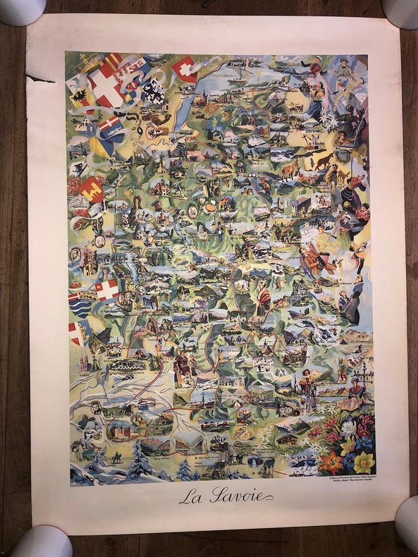
GUILLAUME E. ( illustrateur ) / Editions Efpé ( Editeur Chambéry )
CARTE " LA SAVOIE " en couleurs / Editions Efpé / JANSOL à Chambéry. ( env. 1955 ) . Dimensions : 55 x 75 cm. à toutes marges. Editions FOLKLORE ET PROVINCES DE FRANCE. illustrateur E. Guillaume.Tirage à 300 exemplaires sur vélin des papeteries de Rives. Nota: Les exemplaires de cette carte sont donc très rares.JOLI TIRAGE, très décoratif. TRES BELLE IMPRESSION. à noter une petite déchirure en marge sans atteinte à l'illustration.
書籍販売業者の参照番号
: 2626
|
|
|
GUILLAIN ROBERT
Dans 30 ans la chine .
1965 Editions du seuil 1965 état d'usage 302 pages in 8 broché.
書籍販売業者の参照番号
: 7641
|
|
|
GUIDO PEROCCO
La Confrérie Dalmate des Saints Georges et Tryphon (Venise).
L'Ecole Dalmate Venise, 1983, 48 pages, in 12 broché, bon état.
書籍販売業者の参照番号
: 10005
|
|
|
GUIBERT-FOURRÉ, Florence
La Géographie de nos grands-mères. Archives & Culture. 2008.
1 volume à l'italienne plein cartonnage illustré, 71 p. + illustrations. Comme neuf.
書籍販売業者の参照番号
: 23361

|
|
|
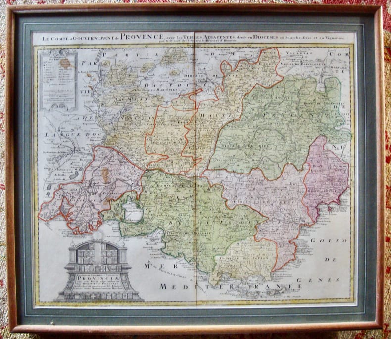
Guillaume de l’Isle,
Le Comté et Gouvernement de Provence, avec les terres adjacentes, divisé en diocèses ...
Chez les héritiers d’Homann très bon Hormann XVIIè siècle
書籍販売業者の参照番号
: 6010
|
|
|
GUILLEMIN-TARAYRE, Edmond
Mission scientifique au Mexique et dans l’Amérique Centrale, géologie, description des anciennes possessions mexicaines du Nord.
Paris, Imprimerie Nationale, 1871, in-folio de 216pp., 19 planches repliées, exemplaire débroché, dos absent, 1ere de couverture salie et ébarbée, petite mouillure angulaire.
書籍販売業者の参照番号
: PHO-1637
|
|
|
Guilbert Gabriel.
LA PREVISION SCIENTIFIQUE DU TEMPS. Traité Pratique.
(Codice SC/0610) In 8º 438 pp. Première édition illustrée avec 21 figures et 7 planches hors texte. Broché, dos dérelié, plats passés (manques, taches), intérieur en bon état. ~~~ SPEDIZIONE IN ITALIA SEMPRE TRACCIATA

|
|
|
GUILLAUME DELISLE, (1675-1726).
[MAP] Carte de la grece ou turquie d'Europe.
Very Good French Original decorated map. Hand-coloured. Oblong elephant folio. (54 x 76 cm). In French. Shows Greece, Archipelago, Isle de Candie, Asia Minor (Western side), and East Mediterranean. Delisle od de l'Isle was a French cartographer known for his popular and accurate maps of Europe and the newly explored Americas. At 27, Delisle was admitted into the French Académie Royale des Sciences, an institution financed by the French state. After that date, he signed his maps with the title of "Géographe de l'Académie". Five years later, he moved to the Quai de l'Horloge in Paris, a true publishing hub where his business prospered. Delisle's progress culminated in 1718 when he received the title of Premier Géographe du Roi. He was appointed to teach geography to the Dauphin, King Louis XIV's son, a task for which he received a salary. Again, his father's reputation as a man of science probably helped the younger Delisle. Historian Mary Sponberg Pedley says, 'once authority was established, a geographer's name might retain enough value to support two or three generations of mapmakers'. Delisle's case, it could be said that his accomplishments surpassed his father's. Up to that point, he had drawn maps not only of European countries, such as Italy, Spain, Germany, Great Britain, Poland, and regions such as the Duchy of Burgundy, but he had also contributed to the empire's claims to recently explored continents of Africa and the Americas. Like many cartographers of his day, Delisle did not travel with the explorers. He drew maps mostly in his office, relying on a variety of data. The quality of his maps depended on a solid network to provide him first-hand information. Given his family's and his own reputation, Delisle had access to fairly recent accounts of travellers who were returning from the New World, which gave him an advantage over his competitors. Being a member of the Académie, he also kept current with recent discoveries, especially in astronomy and measurement. When he could not confirm the accuracy of a source, he would indicate it clearly on his maps. For instance, his Carte de la Louisiane shows a river that the baron of Lahontan claimed he discovered. As no one else could validate it, Delisle noted a warning to the viewer that it might not exist. (Source: Wikipedia). Tooley, p.43.
|
|
|
Guiso Maria Antonietta - Muratore Nicoletta
Ad usum navigatium. Carte nautiche Manoscritte di Gerard van Keulen. 1709-1713.
Bross., cm 28,5x22,5, pp 213,85 tavv. a col..

|
|
|
 検索結果のメールを受信する
 PDFファイルの検索結果をダウンロード
 RSSフィード


