|
HENRI BAUDSON
Le chateau de Crussol.
1956 Editions Audin, préface du marquis Louis de Crussol d'Uzés, 77 pages, + 8 planches, etat d'usage, usures, quelques rousseurs, dos fatigué.
書籍販売業者の参照番号
: 9105
|
|
|
HENRI SALADIN
Les villes d'art célèbres : Tunis et Kairouan.
Librairie Renouard Laurens,1908, 142 pages + 110 gravures, in 8 reliure demi chagrin cartonnée, dos toilé orange, bon état.
書籍販売業者の参照番号
: 12271
|
|
|
HENRI HYMANS
Les villes d'art célèbres : Bruxelles.
Librairie Renouard Laurens, 1910, 188 pages + 139 gravures, in 8 reliure demi chagrin cartonnée, dos toilé orange, bon état.
書籍販売業者の参照番号
: 12273
|
|
|
HENDRIK VAN MARNIX
Ma vie errante en Afrique Australe (aventure d'un émigré hollandais au Transvaal).
Oeuvre Saint-Charles de Grammont (Bruges), prix scolaire décerné en 1928, 125 pages, in 8 reliure éditeur cartonnée percaline, titres et décors or, auteur et traducteur en mention manuscrite, état d'd'usage, usures et frottements sur les bords des plats et les coins.
書籍販売業者の参照番号
: 18717
|
|
|
HENRY (J.F.)
Mémoire sur la projection des cartes géographiques adoptée au dépôt général de la guerre par M. Henry, Colonel au Corps impérial des Ingénieurs-géographes publié par ordre de S.E. Mr Le Duc De Feltre pour faire suite au mémorial topographique et militaire -- EDITION ORIGINALE -- ENVOI DE L'AUTEUR -- BEL EXEMPLAIRE
P., Imprimerie Impériale, 1810, un volume in 4 relié en demi-basane, dos orné de filets dorés (reliure de l'époque), 4pp., 220pp., (1), 4 planches dépliantes
書籍販売業者の参照番号
: 2641
|
|
|
Hendrik de Leth / Topografisch-historische Atlas
Nieuwe geographische en historische atlas van de zeven Vereenigde Nederlandsche provinti n : bestaande inde vijftig nieuwe accurate kaarten, waar onder veele particuliere gemeeten heemraadschappen, plans van de voornaamste steden, met eene korte beschrijving van de provintien, de steden en het merkwaardigste in dezelve; nevens de staat der regeering zoo politicq als kerkelijk &., [1740-1766]
Amsterdam, H. de Leth, 1766 Gebonden in originele lederen band destijds, 156 pagina's. Tekst en 53 uitvouwbare kaarten en plattegronden met zorgvuldig handgekleurde grenzen. 21x13cm. **Een mooi en compleet/intact exemplaar; *Zie; Koeman, Le H 2.
書籍販売業者の参照番号
: 63038
|
|
|
HENDRICKX, M., JANSSEN, L., RUTTEN, H., SANGERS, H.
STEVENSWEERT. MUNTEN EN KAARTEN.
, Leeuwarden, Hugo Suringar, 1983., softcover, originele geillustreerde uitgeversomslag, 21x15cm, 264pp, geillustreerd.
書籍販売業者の参照番号
: 6054
|
|
|
HENDRICKX, M., JANSSEN, L., RUTTEN, H., SANGERS, H.
STEVENSWEERT. MUNTEN EN KAARTEN.
, Leeuwarden, Hugo Suringar, 1983. ( dub.), GEBONDEN, kunstleder, 21x15cm, 264pp, geillustreerd z/w.
書籍販売業者の参照番号
: 13125
|
|
|
HENDRIK WILLEM VAN LOON
LA GEOGRAFIA DI VAN LOON. VERSIONE DALL'AMERICANO DI CARLO COARDI
OTTIME CONDIZIONI, MAI SFOGLIATO. LIEVISSIMI SEGNI DEL TEMPO. Informazioni bibliografiche Titolo: La geografia scritta ed illustrata da Hendrick Willem Van Loon; versione dall'americano di Carlo Coardi Titolo originale: Van Loon's Geography: The Story of the World We Live In, Autore principale: Van Loon, Hendrik Willem Autori: Hendrik Willem Van Loon, Carlo Coardi Editore: Milano: Valentino Bompiani, 1934 Edizione: II, 2, Seconda Lunghezza: XVIII, 449 pagine, [15] c. di tav. : ill. ; 26 cm. Soggetti: Carte geografiche, Mappe, Mercatore, Illustrazioni, Terra, Globo, Storia dell'Umanità, Paesi, Confini, Oceani, Mari, Europa, Asia, Africa, Imperi, Anni trenta, Culture, Civiltà, Usi, Costumi, Prima guerra mondiale, dopoguerra, Versailles, Geografia umana, Storicista, Civiltà, Politica, Orografia, Mappe, Cartografia, Divulgazione scientifica, Geography, Storia dell'Umanità, History of Discovery, Dutch-American historian, The Story of Mankind, Libri vintage, Illustrati, Universale

|
|
|
Henry [J. F.].
Mémoire sur la projection des cartes géographiques, adoptée au dépot général de la guerre; [..] publié par ordre de S. E. M.r le Duc De Feltre, Ministre de la Guerre, pour faire suite au Mémorial topographique et militaire. Topographie.
In-4º (cm. 26,5), cartoncino coevo con rinforzo al dorso (tracce d'usura); pp. IV, 220, [4] in buono stato e 4 tavole ripiegate f.t. in fine. Edizione originale. (SE3)
|
|
|
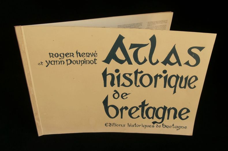
HERVE Roger / POUPINOT Yann
ATLAS HISTORIQUE DE BRETAGNE .
Editions Historiques de Bretagne, 1986, cahier agrafé format oblong ( 310x440mm), 2 pages de texte ( présentation et table des matières ) + XVII planches couleurs hors-texte, tirage à 1000 exemplaires numérotés, celui-ci porte le numéro 31, couverture légèrement salie sinon bon exemplaire.
書籍販売業者の参照番号
: 10369
|
|
|
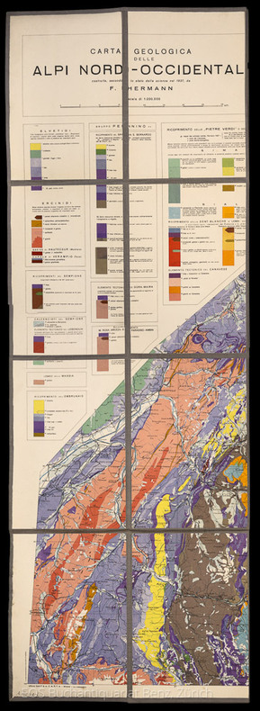
Herman, F.
Carta Geologica delle Alpi Nord-Occidentali.
Milano, 1937. 90 x 125 cm. Farbige Karte, auf Leinen aufgezogen und gefaltet.
書籍販売業者の参照番号
: 1807AG
|
|
|
HERMANS L.
Résultats des observations magnétiques effectuées de 1934 à 1938 pour l'établissement de la carte magnétique du Congo Belge [5 fascicules]
Bruxelles, Librairie Falk fils / Hayez / Institut Royal Colonial Belge 1939-1951 5 fascicules: 88 + 105 + 138 + 71 + 67pp.avec figures dans le texte + 12 + 21 + 15 + [10] planches hors-texte, 31cm., dans la série "Institut Royal Colonial Belge, section des sciences techniques, mémoires, collection in-4o" tome 3 [=FASC.préliminair-Fasc.II] & tome 5 fascicule 3 [=Fasc.IV] & "Univeristé de Liège. Institut d'astronomie et de géodésie. Physique du globe" vol.7.II [=Fasc.I] & vol.7.IV [=Fasc.III], br.orig., bon état [contenu: Fascicule préliminaire: aperçu des méthodes et nomenclature des stations. Fasc.I: Elisabethville et le Katanga (15 avril 1934 -17 janvier 1935 et 1er octobre 1937 - 15 janvier 1938). Fasc.II: Kivu, Ruanda, région des parcs nationaux (20 janvier 1935 - 26 avril 1936). Fasc. III: Région des mines d'or de Kilo-Moto, Ituri, Haut-Uele (27 avril - 16 octobre 1936). Fasc.IV: Haut-Uele, Bas-Uele, Aruwimi, le fleuve de Ponthierville à Bumba (27 novembre 1936 - 20 juin 1937)]
書籍販売業者の参照番号
: C66751
|
|
|
HERDER, B.
Meran.
Litographie von B. Herder, Freiburg, fine XIX secolo. Litografia, b/n, confini stampati a colori, cm 42,2 x 47,8 (il foglio). Dettagliata cartina della zona compresa fra Füssen, Brixen, Trient, Wallenstadt. Buono stato..

|
|
|
Heritage Cartography
Otley 1851 Heritage Cartography Victorian Town Map
Heritage Cartography. Used - Very Good. Former Library book. Great condition for a used book! Minimal wear. Heritage Cartography unknown
書籍販売業者の参照番号
: GRP111230848 ISBN : 1903004098 9781903004098
|
|
|
Herman, F
Carta Geologica delle Alpi Nord-Occidentali.
Milano, 1937. 90 x 125 cm. Farbige Karte, auf Leinen aufgezogen und gefaltet. + Wichtig: Für unsere Kunden in der EU erfolgt der Versand alle 14 Tage verzollt ab Deutschland / Postbank-Konto in Deutschland vorhanden +, A
書籍販売業者の参照番号
: 1807AG

|
|
|
HERMANS L.
Résultats des observations magnétiques effectuées de 1934 à 1938 pour l'établissement de la carte magnétique du Congo Belge [5 fascicules]
5 fascicules: 88 + 105 + 138 + 71 + 67pp.avec figures dans le texte + 12 + 21 + 15 + [10] planches hors-texte, 31cm., dans la série "Institut Royal Colonial Belge, section des sciences techniques, mémoires, collection in-4o" tome 3 [=FASC.préliminair-Fasc.II] & tome 5 fascicule 3 [=Fasc.IV] & "Univeristé de Liège. Institut d'astronomie et de géodésie. Physique du globe" vol.7.II [=Fasc.I] & vol.7.IV [=Fasc.III], br.orig., bon état [contenu: Fascicule préliminaire: aperçu des méthodes et nomenclature des stations. Fasc.I: Elisabethville et le Katanga (15 avril 1934 -17 janvier 1935 et 1er octobre 1937 - 15 janvier 1938). Fasc.II: Kivu, Ruanda, région des parcs nationaux (20 janvier 1935 - 26 avril 1936). Fasc. III: Région des mines d'or de Kilo-Moto, Ituri, Haut-Uele (27 avril - 16 octobre 1936). Fasc.IV: Haut-Uele, Bas-Uele, Aruwimi, le fleuve de Ponthierville à Bumba (27 novembre 1936 - 20 juin 1937)]
|
|
|
Heusser Albert H
The Forgotten General Robert Erskine F. R. S. 1735-1780 Geographer and Surveyor General to the Army of the United States of America
Paterson New Jersey:: The Benjamin Franklin Press 1928. 8" wide by 11" tall. A square reasonably tight copy. Inner hinges are perfect. Bound in the original blue cloth -- moderately rubbed. The front cover is stamped in black with a surveyor's tripod. Gilt lettering on the spine and front cover is still quite bright and shiny. Pages are clean and free of markings except for previous owner's ink name and a thin stain 1/4 inch by 3 inch at the edge of 7 leaves in the margin only NO text is affected. Illustrated with 28 plates -- maps portraits photographs and document facsimiles. Attractive decorative endpapers. For his inventions in the hydraulic engineering field Erskine was elected a fellow of the Royal Society. He left Britain for New Jersey in 1771 where he worked for the American Iron Company whose extensive mines were located in what is now upper Passaic County. In 1775 he organized the men in his employ and was commissioned a captain in the Bergen County militia. Soon afterward General Washington offered him the position of geographer and surveyor-general to the Continental Army. According to the DICTIONARY OF AMERICAN BIOGRAPHY "Erskine worked zealously for the colonial cause and his maps. were important factors in the ultimate victory." Reprinted here are the letters between Erskine and Washington. There is also an appendix that lists 129 of his maps. The DAB cites this book as a primary source for its article on Erskine. Contains chapters on: Erskine the Inventor; Romance of the Ringwood Mines; The Iron Master in the Making; The Hudson River Obstructions and Campaigns against the Indians; and others treating the history of the American Iron Co. New York City Bergen County militia; surveying for Washington Washington at Pompton N.J.; Washington at Morristown for the winter of 1779-1780 etc. From the intro: "Robert Erskine F.R.S. the Surveyor-General of the Continental Army and the trusted friend of the Commander-in-chief was the silent man behind the scenes who mapped out the by-ways and back-roads over the mountains and -- by his familiarity with the great 'middle-ground' between the Hudson Highlands and the Delaware -- provided Washington with that thorough knowledge of the topography of the country which enabled him repeatedly to out-maneuver the enemy.". First Edition. Hard Cover. Very Good condition./No jacket. xii 216pp. 28 plates. . The Benjamin Franklin Press Hardcover
書籍販売業者の参照番号
: 008291
|
|
|
HEWITT Rachel
Map of a Nation. A Biography of the Ordnance Survey. [Second Impression.] NEAR FINE COPY IN UNCLIPPED DUSTWRAPPER
8vo., Second mpression, with coloured plates, monochrome photographs in the text and endpaper maps; black cloth, gilt back, a near fine copy in unclipped dustwrapper.
|
|
|
Heyerdahl Thor
Kon-Tiki. 4000 miglia su una zattera attraverso il Pacifico
illustrazioni in nero

|
|
|
Hickman G. M; W. H. G. Dickins
The lands ane peoples of East Africa. A school certificate geography
8°, 21 cm, pp. XV, 231, numerose tavole fuori testo. Rilegatura editoriale in tela, titolo in oro al piatto e dorso, esemplare ottimo. Timbri editoriali al frontespizio e ai risguardi

|
|
|
Highsmith Richard M Jr ed Adn Jon M Levernz cartography
Atlas of the Pacific Northwest : Resources and Development
Oregon State University Press. Very Good/Good cosed tears small chip light oil stain on lower front in a Brodart mylar cover. . Very Good. Oregon State University Press unknown
書籍販売業者の参照番号
: 2557
|
|
|
HILLAIRET, Jacques
Evocation du vieux Paris - Vieux quartiers, vieilles rues, vieilles demeures historique, vestiges, annales et anecdotes (Tome 1, deuxième édition)
1957 Ed. de Minuit - 1957 - Fort In-8 cartonné - 677 p. - Illustrations et cartes en N&B
書籍販売業者の参照番号
: 101774
|
|
|
Hillary Edmund
Appuntamento al Polo Sud
illustrazioni in bianco e nero

|
|
|
Hirst Bamboo
Il mondo oltre il fiume dei peschi in fiore. Viaggio attraverso la Cina
fotografie di Giorgio Lotti

|
|
|
Historisch-geographische Karten. -
Sammlung von 14 Blättern mit geographischen Karten, teilweise koloriert, 19. Jahrhundert, alle in Passepartout von gleichem Format, in Halbleinen-Mappe.
書籍販売業者の参照番号
: 2129aaf
|
|
|
Hoagland Edward. cartography by Jean Paul Tremblay
African calliope : a journey to the Sudan.
New York : Random House 1979. 1979. Very Good. 1st ed. ; xii 239 p. : maps ; 24 cm. ; ISBN: 0394504186; 9780394504186 LCCN: 78-21807 ; OCLC: 5029254 ; LC: DT154.75; Dewey: 916.24/04/4 ; black cloth with gold lettering in color photographic dustjacket ; "Open this book and enter into a richly d etailed landscape and an exotic society. Follow Hoagland's travels from equatorial mountain forests to the Sahara desert; from small Sudanese towns in the south and west to short stays in the capital Khartoum. Hoagland's eye for detail presents the reader with electrifying images of life in the Sudan - rotten diets disease coups and civil war the traders poachers tribal headmen and those who come to help." ; VG/VG New York : Random House, 1979. hardcover
書籍販売業者の参照番号
: 5077

|
|
|
Hodgkiss A. G.; & A. F. Tatham
Keyguide to Information Sources in Cartography
London: Mansell Publishing Limited 1986. Fine condition. Bright shiny clean square. Sharp corners. NOT a library discard. Hinges are perfect. NO owner's name or bookplate. NOT a remainder. Pages are crisp and unmarked. 1986. First U. K. Edition. This valuable annotated guide describes 796 works on maps and mapmaking. Among them are works about map history discovery and exploration map dating and identification carto-bibliographies contemporary cartography etc. Also listed are 600 major map collections mapping agencies publishers associations and societies. In addition there are sections with advice on cataloguing maps storage conservation etc. Bound in the original green boards stamped in white and black. First U. K. Edition. Hardcover. Fine condition/No jacket as issued. 8vo. x 253pp. Great Packaging Fast Shipping. Mansell Publishing Limited Hardcover
書籍販売業者の参照番号
: 019093 ISBN : 0816014035 9780816014033

|
|
|
Hodgkiss A. G.; & A. F. Tatham
Keyguide to Information Sources in Cartography
New York: Facts on File Publications 1986. Very Good condition. NOT a library discard. Hinges are perfect. NO owner's name or bookplate. Pages are clean crisp and unmarked. 1986. First U. S. Edition. This valuable annotated guide describes 796 works on maps and mapmaking. Among them are works about map history discovery and exploration map dating and identification carto-bibliographies contemporary cartography etc. Also listed are 600 major map collections mapping agencies publishers associations and societies. In addition there are sections with advice on cataloguing maps storage conservation etc. Bound in the original green boards stamped in white and black. First U. S. Edition. Hardcover. Very Good condition/No jacket as issued. 8vo. x 253pp. Great Packaging Fast Shipping. Facts on File Publications Hardcover
書籍販売業者の参照番号
: 019092 ISBN : 0816014035 9780816014033
|
|
|
HODSON D.
Portsmouth Record Series. Maps of Portsmouth before 1801. A Catalogue. NEAR FINE COPY IN DUSTWRAPPER
Folio, First Edition, with frontispiece, maps and endpaper maps; black cloth, gilt back, a near fine copy in dustwrapper.

|
|
|
HODSON Y.
Popular Maps. The Ordnance Survey Popular Edition One-Inch Map of England and Wales 1919-1926.
8vo., First Edition, with 13 coloured plates and 46 illustrations in the text; laminated boards, a near fine copy in unclipped dustwrapper. Includes a full catalogue of all known printings of the 146 sheets of the map
|
|
|
Hoffmann, Detlef und Margot Dietrich:
Gemalte Spielkarten. Deutsches Spielkarten-Museum Leinfelden-Echterdingen,
, _Deutsches Spielkarten-Museum, 1985, softcover 50 pag Illustrated.
書籍販売業者の参照番号
: 62433
|
|
|
Hoffmann, F
Fortschritte d. Kartographie 1969-1982. (Sammelbd. ausgew. Referate v. Veröffentlichungen u. Buchrezensionen). Studienhilfsmittel.
Dresden, 1982. 159 S. St. a. Tit. (TU Dresden, Sekt. Geodäsie u. Kartogr.).
書籍販売業者の参照番号
: 621954
|
|
|
HOFMANN Catherine - LECOQ Danielle -
Lo globe et son image.
Paris, Bibliotheque Nationale de France, 1995, 8vo album brossura con copertina illustrata, pp. 75 con numerose illustrazioni in nero e a colori nel testo.

|
|
|
HOGE E.
Nouvelle contribution à la carte magnétique de la Belgique
Bruxelles, Palais des Académies 1934 50pp.avec figures dans le texte + grande carte dépliante en couleur, 29cm., dans la série "Académie royale de Belgique, classe des sciences, mémoires, collection in-4o, deuxième série" tome 11 fascicule 1, br.orig., non coupé, bon état
書籍販売業者の参照番号
: B66753
|
|
|
HOGE E.
Nouvelle contribution à la carte magnétique de la Belgique
50pp.avec figures dans le texte + grande carte dépliante en couleur, 29cm., dans la série "Académie royale de Belgique, classe des sciences, mémoires, collection in-4o, deuxième série" tome 11 fascicule 1, br.orig., non coupé, bon état
|
|
|
Hogenberg Franz; Braun George
Pianta prospettica di Venezia a volo d'uccello: VENETIA
Incisione in rame (337 x 482) mm, a pieni margini. Foglio (42 x 54) cm. Stato unico. Prima edizione. Esemplare in ottime condizioni, salvo poche segni di ossidazione. In alto al centro della veduta "VENETIA". Molti nomi di località ed isole nell'inciso. In basso elenco, disposto in sette colonne, delle località segnalate nella carta con numeri progressivi da I a XXXV e da 1 a 153. Al centro, dopo la quarta colonna, dentro un cartiglio vignetta rappresentante il corteo ducale durante la festa del Corpus Domini, con sotto breve descrizione dell'evento e sopra ad ogni personaggio della carica ricoperta. Proveniente da "Civitates orbis terrarum", stampato per la prima volta nel 1572, poi ristampato numerose volte in latino, tedesco e francese fino al 1623. L'edizione del 1572 è l'unica che non ha le tavole numerate. Cassini N° 18; Moretto N° 26. Schultz N° 42; Romanelli Biadene N° 13.

|
|
|
HOLLANDER Raymond de
"Topographie générale (2 volumes); tome 1 : généralités, mesures des angles et distances; tome 2 : Les procédés topographiques en planimétrie et nivellement. Collection scientifique de l'Institut géographique national."
Paris, Editions Eyrolles, 1970-1971. 16 x 25, 2 volumes, 363 + 432 pages, nombreuses figures, 1 planche dépliante, reliure d'édition pleine toile, très bon état (sauf cachet d'ex-propriétaire).
書籍販売業者の参照番号
: 90912
|
|
|
Holmden, H.R.
Catalogue des cartes, plans et cartes marines conservés au dépôt des cartes des Archives canadiennes
Imprimerie nationale Fort in-8 Couverture souple Ottawa 1912
書籍販売業者の参照番号
: 3126
|
|
|
HOLLANDER Raymond de, et autres
Loxodromie et projection de Mercator.
Paris/Monaco, Institut Océanographique, 2005. 25 x 31, 240 pp., nombreuses figures en couleurs et en N/B, reliure d'édition carton imprimé, très bon état (sauf 1 cachet d'ex-propriétaire).
書籍販売業者の参照番号
: 90577
|
|
|
HOLDSWORTH MAY, COURTAUD CAROLINE, HU CHUI
The forbidden city, the great within .
1995 Odyssey 1995, 136 pages, in 4 oblong reliure cartonnée toilée ocre avec jaquette bon état .
書籍販売業者の参照番号
: 14408
|
|
|
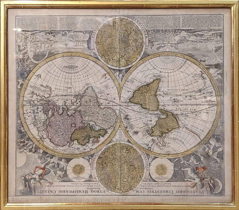
Homann, Johann Baptist (1664–1724).
Planiglobii Terrestris cum utroq Hemisphaerio Caelesti generalis exhibito.
Nürnberg, J.B. Homann, ca. 1720. Altkolorierter Kupferstich. Bildformat: 56 x 65 cm. Blattformat: 51 x 60 cm.
書籍販売業者の参照番号
: 973DG
|
|
|
HOMANN
La Suisse divisée en ses tréze cantons, ses alliez et ses sujets. Helvetia tredecim statibus liberis quos cantones vocant composita.
Norimbergae, Homannianis heredibus, 1751. (mm. 450 x 560). Carta geografica della Svizzera con lieve coloritura dei confini, che illustra anche parte della Lombardia, Piemonte e Veneto.

|
|
|
HOMANN (EREDI).
Charte von America nach Astronomischen Bestimmungen, den neuesten Nachrichten und Charten entworfen von F. L. Güssefeld. Nürnberg bey Homann Erben.
Norimberga, 1796. Incisione in rame all’acquaforte, colore d’epoca, cm 45 x 58 (la parte incisa), in basso a sn., in lastra, “I. Rausch Sc.”, titolo in basso a sn. entro tondo. Si tratta di una rara mappa dell'America, di grande formato, con dettagli interessanti specie nel tratto del Passaggio a Nord Ovest, basati sulle informazioni derivate da Vancouver, La Perouse, Cook, Mac Kenzie e dagli altri esploratori contemporanei; Quivira e Neu Albion compaiono a ovest; si notano le isole Sandwich (isole hawaiane). La presenza del fiume Oregon che scorre dall'area a ovest del Mississippi fino all'Oceano Pacifico è una delle ultime comparse di questo fiume su una mappa. Rifilati il margine superiore e l’inferiore grossomodo in prossimità della battuta della lastra, alcuni leggeri aloni di umido sulla parte sinistra, bella coloritura, buono stato di conservazione di tutto l’inciso. .

|
|
|
Homann Erben ? Penther, Johann Friedrich
Comitatus Stolbergici ad Hercyniam ceterarumq[ue] ad Illustriss. Comites pertinentium Ditionum & terrarum ipsis adjacentium Georgraphica Descriptio. Gezeichnet 22. Oct. 1736 von J. F. Penther. [Altkolorierter Kupferstich, gerahmt / handcolored copper engraving, framed].
o.J. [3 Warenabbildungen] Johann Baptist Homann, geboren 1664, gestorben 1724, gründete sein Geschäft 1702 in Nürnberg. Sein Kartenverlag wurde zu
書籍販売業者の参照番号
: 13825DB

|
|
|
HOMANN JEAN BAPTISTE
PLAN DE LA PLACE DE CORFOU AVEC SES ENVIRONS ASSIEGEE
HOMANN JEAN BAPTISTE PLAN DE LA PLACE DE CORFOU AVEC SES ENVIRONS ASSIEGEE. , 1716, Tracce di acquerellatura. Mediocre (Poor) Discreto es. - presenta buchi, gore e bruniture sparse. acquaforte <br> cm. 57 x 49 <br> <br> <br>

|
|
|
HOMANN JEAN BAPTISTE
PLAN DU SIEGE DE CORFOU
HOMANN JEAN BAPTISTE PLAN DU SIEGE DE CORFOU. , 1716, Acquerellata in epoca. Mediocre (Poor) Es. problematico. acquaforte <br> cm. 57 x 49 <br> <br> <br>

|
|
|
HOMANN Y. B. (1664 - 1724)
TABULA DUCATUS CARNIOLIAE VINDORUM MARCHIAE ET HISTRIAE
HOMANN Y. B. (1664 - 1724) TABULA DUCATUS CARNIOLIAE VINDORUM MARCHIAE ET HISTRIAE. , 1720, Buono (Good) Buon es., tracce leggere di foxing e piccolo restauro d'epoca al margine basso. acquaforte acquerellata a mano <br> inciso cm. 58 x 49 <br> <br> <br>
|
|
|
HOMANN, IO. BAPTISTA.
Imperium Turcicum in Europa, Asia et Africa Regiones.
Norimberga, 1737. Incisione in rame all'acquaforte, coeva coloritura a mano, cm 51 x 61 circa (il foglio) più margini. Ricco cartiglio in basso a sinistra, con figure di schiavi, mendicanti, santi, studiosi e guerrieri. Esemplare rifilato ai margini superiore e inferiore, sciupature agli estremi della brachetta (visibile al superiore), bella e vivace coloritura, nell'insieme buono stato di conservazione. .

|
|
|
HOMANN, IOH. BAPT.
Regnorum Siciliae et Sardinae nec non Melitae seu Maltae Insula cum adjectis. Italiae et Africae Litoribus Nova Tabula.
Norimberga, 1760 circa. Incisione in rame all'acquaforte, colore d'epoca, cm 51 x 58 (il foglio). In alto al centro, importante cartiglio; in basso a sinistra, in riquadro, “Catanae urbis eiuque vicini Montis Aetnae in Sicilia Prospectus”; in basso a destra, in piccolo riquadro “Valletta civitas Maltae celeberrima...”. Tranne il superiore, margini rifilati in prossimità del perimetro graduato, brachetta centrale leggermente ingiallita dalla metà inferiore del foglio, peraltro buon esemplare in bella coloritura. .

|
|
 検索結果のメールを受信する
 PDFファイルの検索結果をダウンロード
 RSSフィード


