|
JENNER
Map of SURREY
1643. UNCOLOURED WORM HOLE ON GRID 4x4 . 1643. unknown
書籍販売業者の参照番号
: Map588
|
|
|
JEREMY SWIFT, PIERRE BOULAT
Le sahara.
Collection les les grandes étendues sauvages ,éditions time life 1982 très bon état 184 pages in 4.Photographies Pierre Boulat .
書籍販売業者の参照番号
: 3647
|
|
|
Jerry Brotton
La storia del mondo in dodici mappe
Coperta cartonata ed illustrata a colori. Ottimo stato, tagli regolari e pagine ben salde alla costa, libro completamente fruibile, n. 9028 della collana "Universale Economica Feltrinelli / Saggi", traduzione dall'inglese di Virginio B. Sala, presenti 38 figure in nero nel testo e 56 illustrazioni a colori fuori testo, prima edizione, numero pagine 526 USATO

|
|
|
JIL SILBERSTEIN
Dans la taïga céleste, entre Chine et Russie l'univers des Touvas.
Albin Michel, collection Latitudes, 492 pages, in 8 broché, bon état, coins légèrement cornés.
書籍販売業者の参照番号
: 12615 ISBN : 222616832
|
|
|
JJE.ROY
Voyage dans l'Inde anglaise.
Alfred Mame, 1884, 168 pages, exemplaire de l'Institution Saint-Georges à Soissons, in 8 reliure éditeur cartonnée, état d'usage, petit manque sur le haut du dos (coiffe supérieure).
書籍販売業者の参照番号
: 12715
|
|
|
JL.MIEGE
Le Maroc.
PUF, collection Que sais-je? 1950, 122 pages, in 12 broché, format poche, état d'usage, papier jauni, coins cornés, légèrement sali, quelques usures.
書籍販売業者の参照番号
: 13066
|
|
|
JO VAN DER ELST
Le Portugal.
Fernand Nathan, collection Pays et Cités d'Art, 1965, 160 pages, in 8 reliure cartonnée, exemplaire bibliothèque (tampons), état d'usage, charnière renforcée, coins et bords des plats frottés, traces d'emplacement (colle) de fiches bibliothèque sur les pages de garde.
書籍販売業者の参照番号
: 8335
|
|
|
JOANNE ADOLPHE
Géographie de seine et oise .
Hachette et cie 1887 état moyen 64 pages in 12.L'ouvrage comporte 17 gravures 1 carte .
書籍販売業者の参照番号
: 1395
|
|
|
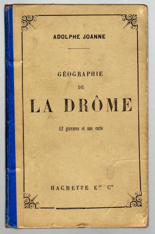
JOANNE Adolphe
Géographie de la Drôme
12 gravures et une carte. Cartonnage d'éditeur Bon Hachette Paris 1885 1 plaquette in-8°
書籍販売業者の参照番号
: 8846
|
|
|
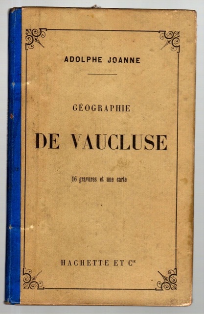
JOANNE Adolphe
Géographie de Vaucluse
16 gravures et une carte. Cartonnage d'éditeur Bon Paris Hachette 1 plaquette in-8°
書籍販売業者の参照番号
: 8847
|
|
|
JOANNE collectif du guide
La Corse illustrée .
1915 hachette et cie collection des guides Joanne 1915 état d'usage 500 pages in 16.Les illustrations sont de Philippe Leca 11 cartes, 3 plans,
書籍販売業者の参照番号
: 6965
|
|
|
Joan BLAEU
AETHIOPIA SUPERIOR vel interior vulgo ABISSINORUM sive presbiteri Ioannis Imperium
Carta in b/n- dimensioni foglio cm 50,5x 59.7- lievi abrasioni ai margini- ed. francese - lievi bruniture ai margini - nel complesso buono stato di conservazione
|
|
|
Joan BLAEU
MONTGOMERIA comitatus et comitatus MERVINA
carta Inghilterra Occ. - dimensioni foglio cm 50,5x60, bella colorazione probabilmente successiva- tratta dall'edizione francese dell'Atlante "Teatro del Mondo"- buono stato di conservazione

|
|
|
JOAN BLAEU
PENBROCHIA , CAERMARIDUNUM ( sud del Galles)
carta geografica- bella colorazione probabilmente successiva- Sud del Galles- dimensioni foglio cm 50x60-tratta dall'edizione francese dell'Atlante "Teatro del Mondo"- buono stato di conservazione

|
|
|
Joan BLAEU
WESTMORIA , COMITATUS Anglice WESTMORLAND
carta Inghilterra del nord- bella colorazione probabilmente successiva- dimensioni foglio cm 50,8 x 60- tratta dall'edizione francese dell'Atlante "Teatro del Mondo"- buono stato di conservazione

|
|
|
Joan Blaeu, Einführung und Texte von Peter van der Krogt
Atlas Maior of 1665. "Der grösste und prachtvollste Atlas, der jemals veröffentlicht wurde". Einführung und Texte von Peter van der Krogt. Nach dem Original aus der Österreichischen Nationalbibliothek Wien. Mit einer Auswahl d. Originaltexte v. Joan Blaeu
Taschen, Köln, Los Angeles, London, Madrid, Paris, Tokyo 2005. Unverletzter S.U Hardcover Neuwertig
書籍販売業者の参照番号
: 027800

|
|
|
JOANNE Adolphe
ITINERAIRE DES PYRENEES
(Pirenei) Paris, Librairie de L. Hachette et C., s.d. In 8°, PP XLVII+ 683n. Tela morbida coeva con titoli in oro al piatto e al tassello. Con diverse tavole (carte geografiche) ripiegate, fuori testo. bruniture sparse.

|
|
|
JOEL COUTURA
Visiter Blaye.
Editions Sud-Ouest, 1990, 30 pages, in 8 broché, bon état.
書籍販売業者の参照番号
: 10078
|
|
|
JOHN GOSS
Blaeu. De grote Atlas van de wereld in de 17de eeuw.
, Lisse, Rebo voor Robas Weesp 1992, 1992 Gebonden, hardcover, 385 x 290 mm, Nederlands, inclusief stofomslag; 1992; 224pp.; Conditie: Goed. ISBN 9789072770288.
書籍販売業者の参照番号
: 55214
|
|
|
JOHN MACKINNON COLLECTIF
Borneo.
Editions Time Life, les grandes étendues sauvages, 1979, bon état, in 4 couverture cartonnée dos et mors toilés, 184 pages de textes et photos.
書籍販売業者の参照番号
: 6496
|
|
|
JOHN ROMER
La bible et l'histoire.
Vernal Philippe Lebaud, 1994, 441 pages, in 8 broché, bon état, coins légèrement cornés et frottés.
書籍販売業者の参照番号
: 12591
|
|
|
JOHN L. STODDARD
Portefolio universel et portefolio colonial.
The Werner compagny Chicago, 1895, in4°, format à l'italienne, état d'usage, il s'agit de deux portfolios reliés en un seul, le premier: villes, paysages, peintures céllebres, natures et arbres du monde entier(Europe, Asie, Afrique, Amerique du Nord et du Sud, de l'ancien et du nouveau monde) le second: paysages, villes, et industries des possessions et dependances françaises.
書籍販売業者の参照番号
: 5215
|
|
|
Johann, A.E. (pseud. di Wollschläger, Alfred Ernst Johann: 1901-1996)
Gross ist Afrika. Europas dunkel Schwester.
<br/> STATO: USATO, MOLTO BUONO.<br/> NOTE: Dedica ms. coeva in splendida calligrafia all'occhietto.<br/> TITOLO: Gross ist Afrika. Europas dunkel Schwester. <br/> AUTORE: Johann, A.E. (pseud. di Wollschläger, Alfred Ernst Johann: 1901-1996) <br/> EDITORE: C. Bertelsmann<br/> DATA ED.: s.d. (1958),<br/> COLLANA: (Dedica ms. coeva in splendida calligrafia all'occhietto.)<br/>
|
|
|
JOHN GOSS
Blaeu. De grote Atlas van de wereld in de 17de eeuw.
Gebonden, hardcover, 385 x 290 mm, Nederlands, inclusief stofomslag; 1992; 224pp.; Conditie: Goed. ISBN 9789072770288.

|
|
|
JOHN GOSS
THE MAPPING OF NORTH AMERICA
IN 4° ( cm.36 X 26 ), pp.184, COPERTINA EDITORIALE IN PIENA TELA RIGIDA AMARANTO CON TITOLO IN ORO AL DORSO + SOVRACOPERTINA ILLUSTRATA A COLORI CON TITOLO ( AL PRIMO PIATTO, AMERICAE SIVE NOVI ORBIS, NOVA DESCRIPTIO DI ABRAHAM ORTELIUS. AL<BR>SECONDO, VIRGINIAE ITEM ET FLORIDAE DESCRIPTO DI JODOCUS HONDIUS ). ANTIPORTA FIGURATA, 85 ILLUSTRAZIONI a col. RIPRODUCENTI MAPPE DEL NORD AMERICA CON SCHEDE DAL 1500 AL 1860. TESTO IN LINGUA INGLESE. PERFETTA CONSERVAZIONE,<BR> RARA BIBLIOGRAFIA.

|
|
|
JOHN MURRAY Ltd
Murray's Handy Classical Maps. Gallia. [Edited by C.B. Grundy]. NEAR FINE COPY
8vo. with large folding coloured map and gazetteer; original printed wrappers, a near fine copy. IN THIS CONDITION A RARE SURVIVAL.

|
|
|
JOHN MURRAY Ltd
Murray's Handy Classical Maps. Mare Aegaeum. [Edited by C.B. Grundy]. NEAR FINE COPY
8vo. with large folding coloured map and gazetteer; original printed wrappers, a near fine copy. IN THIS CONDITION A RARE SURVIVAL.

|
|
|
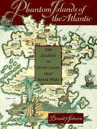
Johnson Donald S
Phantom Islands of the Atlantic: The Legends of Seven Lands That Never Were
New York: Walker & Co. Hardcover. 1994. 2nd Printing. 8vo 220pp . Fine in Fine DJ. B&W Illustrations Tales of seven nonexistent lands conjured out of myth or human error but nonetheless appearing on maps for centuries . Walker & Co. hardcover
書籍販売業者の参照番号
: 013330 ISBN : 0802713203 9780802713209
|
|
|
Johnson Hildegard Binder
Carta Marina World Geography in Strassburg 1525
Minneapolis: University of Minnesota Press 1963. Fine condition in a Fine clear plastic dust jacket. NO chips. NO tears. NO creases. Bright clean square and tight. Sharp corners. Hinges are perfect. Previous owner's bookplate on pastedown endpaper. NOT a library discard. Pages are fresh and crisp. A publication from the James Ford Bell Collection in the University of Minnesota Library. Limited to 750 numbered copies; this being # 609. Complete with folding map in rear pocket. Title page portrait of Lorenz Fries. Bound in the original dark gray decorated boards with a yellow paper label on the spine. Complete with clear plastic dust jacket. First Edition Limited to 750 copies. Hardcover. Fine condition/Fine dust jacket. 8vo. ix 161pp. Great Packaging Fast Shipping. University of Minnesota Press Hardcover
書籍販売業者の参照番号
: 019072
|
|
|
Johnston Keith
THE PHYSICAL ATLAS OF NATURAL PHENOMENA 30 Fine Hand-Coloured Maps
Edinburgh and London: William Blackwood & Sons 1850. 22 x 14.5 inches 57x38cms published simultaneously with divisions concerning the Geology Meteorology Phytology and Zoology of the world WITH a total of 30 maps AS CALLED-FOR. ALL DOUBLE PAGE AND HAND-COLOURED each plate measures 67x45cms. Bound in the orginal half-calf binding with cloth boards. Attractive sound spine but some wear. The 1st edition as published 1848 but with 1850 to the title-page. The large orignal edition with 30 beautiful hand-coloured engraved plates hinged. The first 1848 issue was engraved with some plates hand-coloured. This slightly later issue has all the plates engraved and with hand-colouring and the second issue of 1856 had lithographic plates with some printed colour and some hand-colour. A SCARCE ITEM. The best set of plates. 1st edition 2nd issue. Hard Back. Fine. Imperial Folio. Atlas. William Blackwood & Sons hardcover
書籍販売業者の参照番号
: Map883
|
|
|
Johnston Alexander Keith
THE ROYAL ATLAS OF MODERN GEOGRAPHY
London: William Blackwood 1875. 20 x 135 inches. 48 double page folding colour maps and the North Polar Chart as a frontis. Fine original red half calf binding with gilt titles. Specail; index after each map. The fourth edition with each map updated to reflect the ever changing speed of the changes taking place in the industrail age. Dedication page to Queen Victoria. Each map as an adjacent index bound in and a prospectus for the companion book to the atlas is bound in at the front Atlas Geographicus' pub. separately. A complete and fine copy. New Edition. Hardback. Fine. Elephant Folio - over 15" - 23" tall. William Blackwood Hardcover
書籍販売業者の参照番号
: Pa620
|
|
|
JOLLY, D.C. (Ed.)
Antique Maps, Sea Charts, City Views, Celestial Charts & Battle Plans. Price Record & Handbook for 1985.
Brookline/Mass. Jolly, 1985. 8, 280 S. m. einigen Abb. OLwd.
書籍販売業者の参照番号
: 1247965
|
|
|
JOLLY, D.C. (Ed.)
Antique Maps, Sea Charts, City Views, Celestial Charts & Battle Plans. Price Record & Handbook for 1987.
Brookline/Mass. Jolly, 1987. 8, 280 S. m. einigen Abb. OLwd.
書籍販売業者の参照番号
: 1247966
|
|
|
JON SVENSSON
Nonni, Nonni part en Suède.
Editions Alsatia, 1945, 198 pages, in 8 broché, bon état, papier jauni, quelques usures sur bords des plats, petites déchirures sur pages de garde.
書籍販売業者の参照番号
: 10182
|
|
|
JONATHAN POTTER
COUNTRY LIFE BOOK OF ANTIQUE MAPS
IN 4°, pp.192, COPERTINA EDITORIALE IN PIENA TELA CARTONATA RIGIDA ROSSA CON TITOLO AL DORSO + SOVRACOPERTINA ILLUSTRATA A COLORI CON TITOLO. VOLUME RICCAMENTE ILLUSTRATO in b/n/col. ANCHE a pp. CONTIENE : LOOKING AT MAPS, MAPPING THE WORLD AND ITS COUNTRIES, GLOBES, CURIOSITES AND MINIATURES. TESTO SU DUE COLONNE IN LINGUA INGLESE. OTTIMA CONSERVAZIONE. ID 4851

|
|
|
Jones Robert H./Wagner Bernhard H. cartography
Disrupted Decades: The Civil War and Reconstruction Years
NY: Charles Scribner's Sons 1973. 3rd paperback printing. VG. xvi 543 p. maps footnotes biblio index 8vo paperback; Charles Scribner's Sons paperback
書籍販売業者の参照番号
: 66341 ISBN : 068412579X 9780684125794

|
|
|
Jones Gwyn
Antichi viaggi di scoperta in Islanda, Groenlandia e America
numerose cartine tavole in bianco e nero fuori testo

|
|
|
Jones,Emrys.
Metropoli. Le più grandi città del mondo.
<br/> STATO: USATO, ACCETTABILE.<br/> NOTE: Alcune sottolineature nt.<br/> TITOLO: Metropoli. Le più grandi città del mondo. <br/> AUTORE: Jones,Emrys.<br/> CURATORE: Traduz.di Giovanni Gozzini. Introduz.di Cesare de Seta.<br/> EDITORE: Donzelli Ed.<br/> DATA ED.: 1993,<br/> COLLANA: Coll.Universale,55.<br/> EAN: 9788879897532

|
|
|
Joris Van Grieken, Robert Nouwen,
Belgie in oude prenten / La Belgique en estampes anciennes 1525-1875
BE - , Lannoo, 2017 cartonnage illustre de l'editeur / Gebonden ineen fraai linnen band, Onlongformaat, 442 pagina's: 400x340. fraai boek ! NIEUW!! . ISBN 9789401447348.
書籍販売業者の参照番号
: 50939
|
|
|
Jorré,Georges.
L'U. R. S. S. La terre et les hommes.
<br/> STATO: DA COLLEZIONE, BUONO.<br/> NOTE: Piccolo strappetto alla copertina.<br/> TITOLO: L'U.R.S.S. La terre et les hommes. <br/> AUTORE: Jorré,Georges.<br/> EDITORE: Sefi Ed.<br/> DATA ED.: 1946,<br/> COLLANA: Coll.Géographie du Monde.<br/> Testo in francese

|
|
|
Joseph Roux
Golfe de Venise
Incisione in rame, foglio di 101 x 59 cm. Carta nautica del Golfo di Venezia dove sono segnate città costiere, profondità ed ancoraggi del Mediterraneo. In alto a destra dentro battuta "VII Feuille. Avec Privilege du Roy a Marseille. Chez Joseph Roux Hydrographe du Roy sur le Port a St. Jean". Proveniente da: "Recueil des principaux plans, des ports, et rades de la mer Mediterranèe. ... Par son trés humble Serviteur Joseph Roux Hydrographe du Roy. Marsiglia 1764". Lieve alone di gora al margine sinistro. Raro ed in ottime condizioni.

|
|
|
Jouannin, Joseph Marie; Gaver, Jules : van
Turchia di G. M. Jovannin e Giulio van Gaver ; traduzione a cura di A. F. Falconetti
8°, 23 cm, pp. 482; una carta geografica ripiegata e 96 tavole incise fuori testo, testo su due colonne, rilegatura coeva in mezza pelle, titolo in oro su tassello al dorso, piatti marmorizzati. Fa parte di: L'universo, storia e descrizione di tutti i popoli ec. loro religioni, costumi, usanze ec. Leggero tarlo all'angolo inferiore delle prime 50 carte e all'angolo superiore delle ultime 25 carte lontano dal testo, strappo a 5 tavole, per il resto esemplare molto buono

|
|
|
Jouvin de Rochefort Albert?
Plan de Tolose divisé en huict capitoulats.?
Incisione su rame, carta vergata forte; foglio 570 x 780 mm, (522x 608 mm alla battuta). Mappa di Tolosa molto rara.considerato il primo mappe moderne della città. E 'dedicata a Capitouls (consiglio comunale eletto) giudici e amministratori della città, così come Toulouse gardiage (territorio adiacente alla città). La dedica del cartiglio è decorato con la stemma reale.

|
|
|
JOËL VERNET
Visage de l'absent.
2005 L'Escampette Editions Récit, 2005, 112 pages, in 8 broché, très bon état.
書籍販売業者の参照番号
: 14075
|
|
|
JUGOSLAVIA (Carta dimostrativa della).
(Carta dimostrativa della parte ovest).
Grande carta di cm. 125x97, a colori, con delineate le varie zone di occupazione italo-tedesca. Segni di piegatura.
|
|
|
JULES ILLYES
Ceux des Pusztas.
NRF Gallimard, 1943, exemplaire de bibliothèque, 262 pages, in 8 broché, bon état général, légèrement insolé et jauni, traduction du hongrois Paul Eugène Regnier.
書籍販売業者の参照番号
: 10131
|
|
|
Jules Chancel, Mathilde Majorel, Véronique Tahon.
Grand atlas de la Terre. Plus de 200 cartes et schemas.
Ce Grand Atlas de la Terre, véritablement remarquable, alterne des images satellitaires bien localisées, d'une grande beauté et d'un exceptionnel intérêt, et un ensemble de cartes nettement plus détaillées que celles des habituels atlas scolaires. Une belle réussite qui exprime la raison d'être de la géographie : montrer les splendeurs du monde et aider à mieux le comprendre. <br/> STATO: USATO, COME NUOVO.<br/> TITOLO: Grand atlas de la Terre. Plus de 200 cartes et schemas. 85 photos satellitaires d'une prècision et d'une beauté stupéfiantes. Un index de 60.000 noms.<br/> AUTORE: Jules Chancel, Mathilde Majorel, Véronique Tahon.<br/> CURATORE: Préface Yves Lacoste.<br/> EDITORE: Larousse<br/> DATA ED.: 2007,<br/> EAN: 9782035212047
|
|
|
Jules Chancel, Mathilde Majorel, Véronique Tahon.
Grand atlas de la Terre. Plus de 200 cartes et schemas.
Ce Grand Atlas de la Terre, véritablement remarquable, alterne des images satellitaires bien localisées, d'une grande beauté et d'un exceptionnel intérêt, et un ensemble de cartes nettement plus détaillées que celles des habituels atlas scolaires. Une belle réussite qui exprime la raison d'être de la géographie : montrer les splendeurs du monde et aider à mieux le comprendre. <br/> STATO: USATO, COME NUOVO.<br/> TITOLO: Grand atlas de la Terre. Plus de 200 cartes et schemas. 85 photos satellitaires d'une prècision et d'une beauté stupéfiantes. Un index de 60.000 noms.<br/> AUTORE: Jules Chancel, Mathilde Majorel, Véronique Tahon.<br/> CURATORE: Préface Yves Lacoste.<br/> EDITORE: Larousse<br/> DATA ED.: 2009,<br/> EAN: 9782035825964
|
|
|
JUVENILE.
Geography and Astronomy familiarized. For Youth of both sexes.
First Edition, 32mo, hand-coloured double-hemisphere map as frontispiece, engraved plate, slightly dust soiled, 64 pp., contemporary half red morocco, upper cover detached. Issued as part of the 'Library for Youth' series. The ESTC reords copies at L, C, CtW (imperfect), CLU, FU, InU-L and OOxM.
|
|
|
JÄGER, E
Prussia-Karten 1542 - 1810. Geschichte der kartographischen Darstellung Ostpreußens vom 16. bis zum 19. Jahrhundert. Entstehung der Karten - Kosten - Vertrieb. Bibliographischer Katalog.
(Weißenhorn), A. H. Konrad, (1982). Quer-4to. 324 m.m. zahlr. einfarb. Abb. im Text u. auf 24 Tafelseiten, 13 Farbtafeln (Schriften des Nordostdeutschen Kulturwerks Lüneburg). OLwdbd m. OUmschlag.
書籍販売業者の参照番号
: 2135010
|
|
 検索結果のメールを受信する
 PDFファイルの検索結果をダウンロード
 RSSフィード


