|
|
|
Jügel, Carl und Hendschel, Ulrich:
Post- und Reise-Karte von Deutschland und den Nachbarstaaten bis London, Paris, Montpellier, Nizza, Florenz, Pesth, Warschau und Kopenhagen nach den neuesten und zuverlässigsten Quellen bearbeitet.
Frankfurt a. M. Carl Jugel, Mehrfach gef. grenzkolorierte Karte auf Leinen aufgezogen, gestochen und gezeichnet von Jos. Back u. C. Sauter. Blattgrösse: 108 x 126 cm.
書籍販売業者の参照番号
: 1676AG

|
|
|
Jügel, Carl und Hendschel, Ulrich
Post- und Reise-Karte von Deutschland und den Nachbarstaaten bis London, Paris, Montpellier, Nizza, Florenz, Pesth, Warschau und Kopenhagen nach den neuesten und zuverlässigsten Quellen bearbeitet.
Frankfurt a. M., Carl Jugel. Mehrfach gef. grenzkolorierte Karte auf Leinen aufgezogen, gestochen und gezeichnet von Jos. Back u. C. Sauter. Blattgrösse: 108 x 126 cm. + Wichtig: Für unsere Kunden in der EU erfolgt der Versand alle 14 Tage verzollt ab Deutschland / Postbank-Konto in Deutschland vorhanden +, Abb.
書籍販売業者の参照番号
: 1676AG

|
|
|
JÜRGEN SPOHN
Une nuit à Venise.
Editions JC Lattes, L'Iconothèque, 1993, 131 pages, in 12 broché, très bon état.
書籍販売業者の参照番号
: 10003
|
|
|
K. Fianu, D.J. Guth
Ecrit et pouvoir dans les chancelleries medievales: espace francais, espace anglais
, Brepols - Harvey Miller, 1997 Hardcover. 348 p., 165 x 240 mm, Languages: French, Including an index. Fine copy. ISBN 02150060200.
書籍販売業者の参照番号
: 45507
|
|
|
K. di SPRUNER, Dr. -
Atlante storico-geografico. Ventitre carte illuminate incise in rame.
Milano, Hoepli, 1892, 8vo album brossura con copertina posticcia muta, pp. (22) con 23 carte storico-geografiche incise in rame e a colori.

|
|
|
K.u.k. MILITAR-GEOGRAPHISCHEN INSTITUT.
[MAP of BALKANS] 40-44 Zajecar. [Macedonia, Donau -Danube- River, Hungary and Bulgaria border, East Serbia].
Very Good German Original color map on cloth. A little foxing on cloth. Very good. Folded. Folio. (57 x 43 cm). Toponyms in German. [MAP of BALKANS] 40-44 Zajecar. [Macedonia, Donau -Danube- River, Hungary and Bulgaria border, East Serbia].
|
|
|
Kaerius, Petrus Excudit (1571-1624).
Territorium Argentoratense.
(Amstelodami), Ioannes Ianßonius (1588-1664) ca. 1650, 34 x 50 cm Schöne teils handkolorierte Kupferstich-Karte von Strassburg, links unten Titel in Kartusche, rechts oben 2 heraldische Wappen, kleine Beschädigungen am Rand links unten, 1 Blatt.
書籍販売業者の参照番号
: 558.1aaf
|
|
|
Kahmen, H
Untersuchung von analogen u. digitalen Phasenmeßsystemen in d. elektrooptischen Entfernungsmessung. Diss.
München, 1973. 4°. 68 S. OBr. Klammern angerostet. Umschl. m. St. sowie Sign. (BAW. Veröff. d. Dt. Geodät. Komm. C 186).
書籍販売業者の参照番号
: 162380
|
|
|
Kaiser,Michael.
Atlas der Welt Wissen und Reisen. Faszination Erde.
<br/> TITOLO: Atlas der Welt Wissen und Reisen. Faszination Erde. <br/> AUTORE: Kaiser,Michael.<br/> EDITORE: Kunth<br/> DATA ED.: 2005,<br/> EAN: 9783899441277
|
|
|
KAISERLICH un KÖNIGLICHES MILITAR-GEOGRAPHISCHES INSTITUT].
[MAP of ROMANIA] P.8. Jassy (Iashi) - Moldau.
Very Good German Original color map on cloth. A little foxing on cloth. Very good. Folded. Oblong folio. (45 x 51 cm). In German. Shows Tirgu Frumos, Jassi, Tzibana, Kodaesti, Brindza, Negresti, Becesti, Pundzesti, Birlaf, Gaiciana, Urdesti, Falci, etc. [MAP of ROMANIA] P.8. Jassy - Moldau. Scale: 1/300000. (Jassy or Iassy) Iasi is the second-largest city in Romania, after the national capital Bucharest, and the seat of Iasi County. Located in the historical region of Moldavia, Iasi has traditionally been one of the leading centers of Romanian social, cultural, academic and artistic life. The city was the capital of the Principality of Moldavia from 1564 to 1859, then of the United Principalities from 1859 to 1862, and the capital of Romania from 1916 to 1918. (Source: Wikipedia). A sheet of the collection of 'The general map of Central Europe'. appeared in the years between 1873-1876 with the work of Joseph Ritter von Scheda, (1815-1888) who was a general, geographer and cartographer.
|
|
|
KAISERLICH un KÖNIGLICHES MILITAR-GEOGRAPHISCHES INSTITUT].
[MAP of WEST GREECE] L.15. Paramythia (Corfu). Jonisches Meer.
Very Good German Original color map on cloth. A little foxing on cloth. Very good. Folded. Oblong folio. (45 x 51 cm). In German. [MAP of WEST GREECE] L. 15. Paramythia (Corfu). Jonisches Meer. Scale: 1/300000. A sheet of the collection of 'The general map of Central Europe'. appeared in the years between 1873-1876 with the work of Joseph Ritter von Scheda, (1815-1888) who was a general, geographer and cartographer.
|
|
|
KAISERLICH un KÖNIGLICHES MILITAR-GEOGRAPHISCHES INSTITUT].
[MAP of WEST GREECE] L.15. Philiataes (Corfu). Jonisches Meer.
Very Good German Original color map on cloth. A little foxing on cloth. Very good. Folded. Oblong folio. (45 x 51 cm). In German. [MAP of WEST GREECE] L.15. Philiataes (Corfu). Jonisches Meer. Scale: 1/300.000. A sheet of the collection of 'The general map of Central Europe'. appeared in the years between 1873-1876 with the work of Joseph Ritter von Scheda, (1815-1888) who was a general, geographer and cartographer.
|
|
|
KAISERLICH un KÖNIGLICHES MILITAR-GEOGRAPHISCHES INSTITUT].
[MAP] K.12. Ragusa, Dubrovnik.
Good German Original color map on cloth. Some tears on foldings. Good. Folded. Oblong folio. (45 x 51 cm). In German. Shows Stolac, Metkovic, Ljubinje, Bilek, Niksic, Trebinje, Ragusa, Meleda Island, Cattaro, et alli. Ragusa is a Croatian city on the Adriatic Sea. It is one of the most prominent tourist destinations in the Mediterranean Sea, a seaport and the centre of Dubrovnik-Neretva County. A sheet of the collection of 'The general map of Central Europe'. appeared in the years between 1873-1876 with the work of Joseph Ritter von Scheda, (1815-1888) who was a general, geographer and cartographer.
|
|
|
KAISERLICH und KÖNIGLISCHES MILITAR-GEOGRAPHISCHES INSTITUT].
[MAP of OTTOMAN BALKANS] L.14. Berat (Argyrokastro).
Very Good German Original color map on cloth. Folded. Oblong folio. (45 x 51 cm). In German. [MAP of OTTOMAN BALKANS] L.14. Berat (Argyrokastro). Shows South Albanian shores, Corfu, Berat et alli. A sheet of the collection of 'The general map of Central Europe'. appeared in the years between 1873-1876 with the work of Joseph Ritter von Scheda, (1815-1888) who was a general, geographer and cartographer.
|
|
|
KAISERLICH und KÖNIGLISCHES MILITAR-GEOGRAPHISCHES INSTITUT].
[MAP] Q.8. Odessa.
Very Good German Original color map on cloth. A little foxing on cloth. Very good. Folded. Oblong folio. (45 x 59 cm). In German. Shows Kujaljnickij Limani, Dnjesstrowskij Liman, Odessa shores and hinterland. Rare. A sheet of the collection of 'The general map of Central Europe'. appeared in the years between 1873-1876 with the work of Joseph Ritter von Scheda, (1815-1888) who was a general, geographer and cartographer.
|
|
|
KAISERLICH-KÖNIGLISCHES MILITAR-GEOGRAPHISCHES INSTITUT].
[MAP of ANATOLIA] O.14. Brussa. [Southern Brussa - Gönen - Manias Göl -Lake-, Anatolien, Abulonia Göl -Lake-].
Very Good German Original color map on cloth. Folded. A good copy. Oblong folio. (45 x 51 cm). In German. [MAP] O.14. Brussa. [Southern Brussa - Gönen - Manias Göl -Lake-, Anatolien, Abulonia Göl -Lake-]. Shows Abhuitis See, Artynia See, Kirmisli Kasaba, etc. A sheet of the collection of 'The general map of Central Europe'. appeared in the years between 1873-1876 with the work of Joseph Ritter von Scheda, (1815-1888) who was a general, geographer and cartographer.
|
|
|
KAISERLICH-KÖNIGLISCHES MILITAR-GEOGRAPHISCHES INSTITUT].
[MAP of BALKANS] J.10. Glina.
Very Good German Original color map on cloth. Oblong atlas folio. (46 x 52 cm). Toponyms in German. [MAP of BALKANS] J.10. Glina and around. North Bosnia and Herzegovina sheet. A sheet of the collection of 'The general map of Central Europe'. appeared in the years between 1873-1876 with the work of Joseph Ritter von Scheda, (1815-1888) who was a general, geographer and cartographer.
|
|
|
KAISERLICH-KÖNIGLISCHES MILITAR-GEOGRAPHISCHES INSTITUT].
[MAP of BOSNIA-HERZEGOVINA / SARAJEVO] K.11. Bosna-Serai.
Very Good German Original color map on cloth. Chipped on folded places. Otherwise a clean copy. Oblong atlas folio. (46 x 52 cm). Scale: 1/300.000. Toponyms in German. Shows Saraybosna (Sarajevo), and its around, Travnik, Kladanj, G. Yakuf, Konjiva, Gorazda, Mostar et alli. A sheet of the collection of 'The general map of Central Europe'. appeared in the years between 1873-1876 with the work of Joseph Ritter von Scheda, (1815-1888) who was a general, geographer and cartographer.
|
|
|
KAISERLICH-KÖNIGLISCHES MILITAR-GEOGRAPHISCHES INSTITUT].
[MAP of BULGARIA] O.11. Rusçuk. [Ruse]. Donau River, Plevna, Nikoli.
Very Good German Original color map on cloth. Folded. A good copy. Oblong folio. (45 x 51 cm). In German. [MAP of BULGARIA]. Rusçuk. [Ruse]. Donau River, Plevna, Nikoli. A sheet of the collection of 'The general map of Central Europe'. appeared in the years between 1873-1876 with the work of Joseph Ritter von Scheda, (1815-1888) who was a general, geographer and cartographer.
|
|
|
KAISERLICH-KÖNIGLISCHES MILITAR-GEOGRAPHISCHES INSTITUT].
[MAP of BULGARIA] Q.10. Küstendze (Constanta). Bulgaria. Schwarzes Meer (Black Sea).
Very Good German Original color map on cloth. Folded. Oblong folio. (45 x 51 cm). In German. [MAP] Q.10. Küstendze (Constanta). Bulgaria. Schwarzes Meer (Black Sea). A sheet of the collection of 'The general map of Central Europe'. appeared in the years between 1873-1876 with the work of Joseph Ritter von Scheda, (1815-1888) who was a general, geographer and cartographer.
|
|
|
KAISERLICH-KÖNIGLISCHES MILITAR-GEOGRAPHISCHES INSTITUT].
[MAP of CENTRAL ALBANIA] L.13. Durazzo.
Very Good German Original color map on cloth. Chipped on folded places. It needs repair. Oblong atlas folio. (46 x 52 cm). Toponyms in German. Shows Durach (Durazzo) and its around, Musakija at south, western shores of Albania, Elbasan, and three bays (Drin Golf etc). A sheet of the collection of 'The general map of Central Europe'. appeared in the years between 1873-1876 with the work of Joseph Ritter von Scheda, (1815-1888) who was a general, geographer and cartographer.
|
|
|
KAISERLICH-KÖNIGLISCHES MILITAR-GEOGRAPHISCHES INSTITUT].
[MAP of CROATIA] K.10. Brood.
Very Good German Original color map on cloth. Chipped on folded places. Otherwise a clean copy. Oblong atlas folio. (46 x 52 cm). Toponyms in German. Shows Brood area and its around, Djakovo, Tuzla etc. A sheet of the collection of 'The general map of Central Europe'. appeared in the years between 1873-1876 with the work of Joseph Ritter von Scheda, (1815-1888) who was a general, geographer and cartographer.
|
|
|
KAISERLICH-KÖNIGLISCHES MILITAR-GEOGRAPHISCHES INSTITUT].
[MAP of GALLIPOLI]. P.14. Gallipoli [and Edremid Gulf, Imbros, Tenedos, Lesbos (Midilli), Aivali (Ayvalik) and North Aegean shores of Anatolia].
Very Good German Original color map on cloth. Chipped on folded places. Otherwise a clean copy. Oblong atlas folio. (46 x 52 cm). Scale: 1/300.000. Toponyms in German. Shows Gallipoli [and the Hellespont, Edremid Gulf, Imbros, Tenedos, Lesbos (Midilli), Aivali (Ayvalik) and North Aegean shores of Anatolia]. A sheet of the collection of 'The general map of Central Europe'. appeared in the years between 1873-1876 with the work of Joseph Ritter von Scheda, (1815-1888) who was a general, geographer and cartographer.
|
|
|
KAISERLICH-KÖNIGLISCHES MILITAR-GEOGRAPHISCHES INSTITUT].
[MAP of GREECE] N.14. Salonik (Salonica - Thessaloniki - Salonique). Platamora, Aegaisches Meer, Larissa.
Very Good German Original color map on cloth. Folded. A good copy. Oblong folio. (45 x 51 cm). In German. [MAP of GREECE] N.14. Salonik (Salonica - Thessaloniki - Salonique). Platamora, Aegaisches Meer, Larissa. A sheet of the collection of 'The general map of Central Europe'. appeared in the years between 1873-1876 with the work of Joseph Ritter von Scheda, (1815-1888) who was a general, geographer and cartographer.
|
|
|
KAISERLICH-KÖNIGLISCHES MILITAR-GEOGRAPHISCHES INSTITUT].
[MAP of GREECE] N.15. Phersala [Farsala]. Gulf von Volo, Canal v. Triche, I. Egripo (Euboea, Evvia), Canal Orei, Kirtzini Armiro, Chalkis, etc.
Very Good German Original color map on cloth. Folded. A good copy. Oblong folio. (45 x 51 cm). In German. [MAP of GREECE] N.15. Phersala [Farsala]. Gulf von Volo, Canal v. Triche, I. Egripo (Euboea, Evvia), Canal Orei, Kirtzini Armiro, Chalkis, etc. A sheet of the collection of 'The general map of Central Europe'. appeared in the years between 1873-1876 with the work of Joseph Ritter von Scheda, (1815-1888) who was a general, geographer and cartographer.
|
|
|
KAISERLICH-KÖNIGLISCHES MILITAR-GEOGRAPHISCHES INSTITUT].
[MAP of OTTOMAN BALKANS] 0.13. Xanthi. [Northern Greece - Western Thrace] Iskeçe.
Very Good German Original color map on cloth. Folded. A good copy. Oblong folio. (45 x 51 cm). In German. [MAP of OTTOMAN BALKANS] 0.13. Xanthi. [Northern Greece - Western Thrace] Iskeçe. A sheet of the collection of 'The general map of Central Europe'. appeared in the years between 1873-1876 with the work of Joseph Ritter von Scheda, (1815-1888) who was a general, geographer and cartographer.
|
|
|
KAISERLICH-KÖNIGLISCHES MILITAR-GEOGRAPHISCHES INSTITUT].
[MAP of OTTOMAN BALKANS] 0.13. Xanthi. [Northern Greece - Western Thrace]. Iskeçe.
Very Good German Original color map on cloth. Folded. A good copy. Oblong folio. (45 x 51 cm). In German. [MAP of OTTOMAN BALKANS] 0.13. Xanthi. [Northern Greece - Western Thrace]. Iskeçe. A sheet of the collection of 'The general map of Central Europe'. appeared in the years between 1873-1876 with the work of Joseph Ritter von Scheda, (1815-1888) who was a general, geographer and cartographer.
|
|
|
KAISERLICH-KÖNIGLISCHES MILITAR-GEOGRAPHISCHES INSTITUT].
[MAP of OTTOMAN BALKANS] L.12. Durazzo. Vilajet Scutari - Nord Albanien - Prizren. [Scutari Province - North Albania].
Very Good German Original color map on cloth. Folded. A good copy. Oblong folio. (45 x 51 cm). In German. [MAP of OTTOMAN BALKANS] L.12. Durazzo. Vilajet Scutari - Nord Albanien - Prizren. [Scutari Province - North Albania]. A sheet of the collection of 'The general map of Central Europe'. appeared in the years between 1873-1876 with the work of Joseph Ritter von Scheda, (1815-1888) who was a general, geographer and cartographer.
|
|
|
KAISERLICH-KÖNIGLISCHES MILITAR-GEOGRAPHISCHES INSTITUT].
[MAP of OTTOMAN BALKANS] L.13. Durazzo. Vilajet Scutari - Mittel Albanien. [Scutari Province - Middle Albania].
Very Good German Original color map on cloth. Folded. A good copy. Oblong folio. (45 x 51 cm). In German. [MAP of OTTOMAN BALKANS] L.13. Durazzo. Vilajet Scutari - Mittel Albanien. [Scutari Province - Middle Albania]. Turkish toponyms in German. A sheet of the collection of 'The general map of Central Europe'. appeared in the years between 1873-1876 with the work of Joseph Ritter von Scheda, (1815-1888) who was a general, geographer and cartographer.
|
|
|
KAISERLICH-KÖNIGLISCHES MILITAR-GEOGRAPHISCHES INSTITUT].
[MAP of OTTOMAN BALKANS] L.14. Berat.
Very Good German Original color map on cloth. Oblong atlas folio. (46 x 52 cm). Toponyms in German. [MAP of OTTOMAN BALKANS] L.14. Berat. Shows South Albanian shores, Corfu, Berat et alli. Lithography. (Argyrokastro). A sheet of the collection of 'The general map of Central Europe'. appeared in the years between 1873-1876 with the work of Joseph Ritter von Scheda, (1815-1888) who was a general, geographer and cartographer.
|
|
|
KAISERLICH-KÖNIGLISCHES MILITAR-GEOGRAPHISCHES INSTITUT].
[MAP of OTTOMAN BALKANS] M.13. Monastir (Köprülü). Macedonia.
Very Good German Original color map on cloth. Folded. Oblong folio. (45 x 51 cm). In German. [MAP of OTTOMAN BALKANS] M.13. Monastir (Köprülü). Macedonia. A sheet of the collection of 'The general map of Central Europe'. appeared in the years between 1873-1876 with the work of Joseph Ritter von Scheda, (1815-1888) who was a general, geographer and cartographer.
|
|
|
KAISERLICH-KÖNIGLISCHES MILITAR-GEOGRAPHISCHES INSTITUT].
[MAP of OTTOMAN BALKANS] N.13. Seres. [Serres]. Greece - Macedonia.
Very Good German Original color map on cloth. Folded. A good copy. Oblong folio. (45 x 51 cm). In German. [MAP of OTTOMAN BALKANS] N.13. Seres. [Serres]. Greece - Macedonia. A sheet of the collection of 'The general map of Central Europe'. appeared in the years between 1873-1876 with the work of Joseph Ritter von Scheda, (1815-1888) who was a general, geographer and cartographer.
|
|
|
KAISERLICH-KÖNIGLISCHES MILITAR-GEOGRAPHISCHES INSTITUT].
[MAP of OTTOMAN BALKANS] P.13. Dimotika. [Northern Greece - Western Thrace - Evros].
Very Good German Original color map on cloth. Folded. A good copy. Oblong folio. (45 x 51 cm). In German. [MAP of OTTOMAN BALKANS] P.13. Dimotika. [Northern Greece - Western Thrace - Evros]. A sheet of the collection of 'The general map of Central Europe'. appeared in the years between 1873-1876 with the work of Joseph Ritter von Scheda, (1815-1888) who was a general, geographer and cartographer.
|
|
|
KAISERLICH-KÖNIGLISCHES MILITAR-GEOGRAPHISCHES INSTITUT].
[MAP of OTTOMAN BALKANS] P.9. Galatz - Donau River.
Very Good German Original color map on cloth. Folded. A good copy. Oblong folio. (45 x 51 cm). In German. [MAP of OTTOMAN BALKANS] P.9. Galatz - Donau River. A sheet of the collection of 'The general map of Central Europe'. appeared in the years between 1873-1876 with the work of Joseph Ritter von Scheda, (1815-1888) who was a general, geographer and cartographer.
|
|
|
KAISERLICH-KÖNIGLISCHES MILITAR-GEOGRAPHISCHES INSTITUT].
[MAP of ROMANIA] M.10. Orsova. Danube River.
Very Good German Original color map on cloth. Folded. A good copy. Oblong folio. (45 x 51 cm). In German. [MAP of ROMANIA] M.10. Orsova. Danube River. Orsova is a port city on the Danube river in southwestern Romania's Mehedin?i County. It is one of four localities in the county located in the Banat historical region. It is situated just above the Iron Gates, on the spot where the Cerna River meets the Danube. A sheet of the collection of 'The general map of Central Europe'. appeared in the years between 1873-1876 with the work of Joseph Ritter von Scheda, (1815-1888) who was a general, geographer and cartographer.
|
|
|
KAISERLICH-KÖNIGLISCHES MILITAR-GEOGRAPHISCHES INSTITUT].
[MAP of SERBIA] M.11. Krusevac.
Very Good German Original color map on cloth. Chipped on folded places. Otherwise a clean copy. Oblong atlas folio. (46 x 52 cm). Toponyms in German. Shows Krusevac and its around in Serbia. A sheet of the collection of 'The general map of Central Europe'. appeared in the years between 1873-1876 with the work of Joseph Ritter von Scheda, (1815-1888) who was a general, geographer and cartographer.
|
|
|
KAISERLICH-KÖNIGLISCHES MILITAR-GEOGRAPHISCHES INSTITUT].
[MAP of WEST WALLACHIA - CRAIOVA] N.10. Kraiova.
Very Good German Original color map on cloth. Chipped on folded places. Oblong atlas folio. (46 x 52 cm). Toponyms in German. [MAP of WEST WALLACHIA - CRAIOVA] N.10. Kraiova. A sheet of the collection of 'The general map of Central Europe'. appeared in the years between 1873-1876 with the work of Joseph Ritter von Scheda, (1815-1888) who was a general, geographer and cartographer.
|
|
|
KAISERLICH-KÖNIGLISCHES MILITAR-GEOGRAPHISCHES INSTITUT].
[MAP] Mission antipaludique de l'Armee d'Orient: Carte des indices endemiques Macedoine, Thessalie, Serbie meridionale, confins albanais 1917 et 1918.
Very Good French Original b/w map. Oblong: 57x66 cm. In French. Folded. It includes for pieces: Title, structure physique de la region, Thessalie and main part which shows the area from Ohrida Lake on the west to Golf of Thessaloniki on the east. [MAP] Mission antipaludique de l'Armee d'Orient: Carte des indices endemiques Macedoine, Thessalie, Serbie meridionale, confins albanais 1917 et 1918.
|
|
|
KAISERLICH-KÖNIGLISCHES MILITAR-GEOGRAPHISCHES INSTITUT].
[MAP] Q.11. Cap Gülgrad. Kaliakra, Capo Calacria, Celigra Burun [and] Schwarzes Meer (Black Sea).
Very Good German Original color map on cloth. Folded. Oblong folio. (45 x 51 cm). In German. [MAP] Q.11. Cap Gülgrad. Kaliakra, Capo Calacria, Celigra Burun [and] Schwarzes Meer (Black Sea). Bulgarian Black Sea shores. A sheet of the collection of 'The general map of Central Europe'. appeared in the years between 1873-1876 with the work of Joseph Ritter von Scheda, (1815-1888) who was a general, geographer and cartographer.
|
|
|
KAISERLICH-KÖNIGLISCHES MILITAR-GEOGRAPHISCHES INSTITUT].
M.14. Kastoria [Kesriye in the Ottoman period].
Very Good German Original color map on cloth. Chipped on folded places. It needs repair. Oblong atlas folio. (46 x 52 cm). Toponyms in German. Shows Kastoria area in Greece. A sheet of the collection of 'The general map of Central Europe'. appeared in the years between 1873-1876 with the work of Joseph Ritter von Scheda, (1815-1888) who was a general, geographer and cartographer.
|
|
|
KAISERLICH-KÖNIGLISCHES MILITAR-GEOGRAPHISCHES INSTITUT].
O.9. Kronstadt.
Very Good German Original color map on cloth. Chipped on folded places. Oblong atlas folio. (46 x 52 cm). Toponyms in German. A sheet of the collection of 'The general map of Central Europe'. appeared in the years between 1873-1876 with the work of Joseph Ritter von Scheda, (1815-1888) who was a general, geographer and cartographer.
|
|
|
Kammerer, Albert
LA MER ROUGE, L'ABYSSINIE ET L'ARABIE DEPUIS L'ANTIQUITÉ, VOL. II [ONLY] Tome Deuxième: Les Guerres Du Poivre - Les Portugais Dans L'Océan Indien Et La Mer Rouge Au Xvie Siècle- Histoire De La Cartographie Orientale
Binding rubbed and worn, torn along spine, inner hinges strained and starting to crack. Dampstaining to margins of some plates and pages, else contents sound & tight. Endpapers browned. Spine cover browned. Some browning to boards. Some loss to spine cover ends. 1 corner edgeworn. ; Pp263-555 + pls CX-CLXIX, many text figures. Most of this volume concerns the history of cartography and is very nicely illustrated. ; Volume 2 Only; Vol. 2; Folio - over 12" - 15" tall
|
|
|
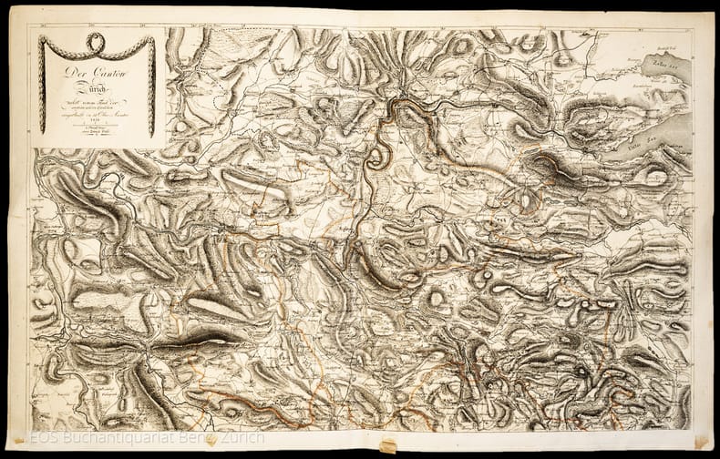
Kanton Zürich. –
Der Canton Zürich nebst einem Theil der angränzenden Cantonen, eingetheilt in 11 Ober-Aemter.
Zürich, Füssli, 1816. 2 Kupferstichkarten. 44 x 70 cm.
書籍販売業者の参照番号
: 1047CG
|
|
|
Karen De Coene
Carte blanche, de diplomatie van Ferraris in een Europa in omwenteling.
, lannoo, 2024 Gebonden, Hardcover 342 pag. 25x 6.8cm. ISBN 9789401495196.
書籍販売業者の参照番号
: 63281
|
|
|
KARL PEUCKER, (1859-1940).
[MAP] Karte von Bulgarien mit Ostrumelien und Tu?rk. Thrakien.; Mit kartographischen und statistischen Beilagen zum Versta?ndnis der orientalischen Krise.
Very Good German Original color map. Folded. A stamp of S. H. Weiss, Constantinople. Elephant folio. (82 x 65 cm). In German. Scale: 1/864.000. [MAP] Karte von Bulgarien mit Ostrumelien und Tu?rk. Thrakien.; Mit kartographischen und statistischen Beilagen zum Versta?ndnis der orientalischen Krise. Showing Bulgaria, Balkans, and Eastern Roumeli, and Turkish / Ottoman Thrace. A rare map. OCLC: 43528174.
|
|
|
Karp Abraham J
From the Ends of the Earth Judaica Treasures of the Library of Congress
New York / Washington: Rizzoli / Library of Congress 1991. Appears unread. Fine condition in a Near Fine dust jacket. The jacket would also be Fine but for some very light surface rubbing i.e. minor shelf wear. NO chips. NO tears. NO ceases. NO fading. Bright shiny clean square and tight. Sharp corners. Hinges are perfect. NO owner's name or bookplate. NOT a remainder. NOT a library discard. Fresh and crisp - apparently never read. 1991. First Edition. A spectacular array of Judaic Treasures with a scholarly and entertaining text complements over 300 color and monochrome photos. Among the highlights are illuminated Haggadot Torah scrolls maps and navigational tables including the ones used by Christopher Columbus Holy Land maps by Ptolemy Ortelius and other cartographic giants books and documents of American Jewish history musical compositions by Irving Berlin and the Gershwins early Hebrew books Einstein's Unified Field Theory manuscripts Sigmund Freud manuscripts letters of Jewish interest from Washington Jefferson Lincoln etc. Published to accompany a traveling exhibition opening at the Library of Congress and sponsored by the Project Judaica Foundation. Bound in the original gilt-stamped black cloth. Complete with dust jacket. Oversize Hardcover. 9.25" wide by 12.25" tall. This large heavy book will require extra postage for Priority and International shipments but only the standard charge for media mail. First Edition. Oversize Hardcover. Fine condition/Near Fine dust jacket. xxiv 376pp. Great Packaging Fast Shipping. Rizzoli / Library of Congress Hardcover
書籍販売業者の参照番号
: 019036 ISBN : 0847814505 9780847814503
|
|
|
Karp Abraham J
From the Ends of the Earth Judaica Treasures of the Library of Congress
New York / Washington: Rizzoli / Library of Congress 1991. Appears unread. Fine condition in a Very Good dust jacket. The jacket is rubbed i.e. normal shelf wear but has NO chips. NO tears. NO ceases. NO fading. Bright clean square and tight. Sharp corners. Hinges are perfect. NO owner's name or bookplate. NOT a remainder. NOT a library discard. Pages are fresh and crisp - apparently never read. 1991. First Edition. A spectacular array of Judaic Treasures with a scholarly and entertaining text complements over 300 color and monochrome photos. Among the highlights are illuminated Haggadot Torah scrolls maps and navigational tables including the ones used by Christopher Columbus Holy Land maps by Ptolemy Ortelius and other cartographic giants books and documents of American Jewish history musical compositions by Irving Berlin and the Gershwins early Hebrew books Einstein's Unified Field Theory manuscripts Sigmund Freud manuscripts letters of Jewish interest from Washington Jefferson Lincoln etc. Published to accompany a traveling exhibition opening at the Library of Congress and sponsored by the Project Judaica Foundation. Bound in the original gilt-stamped black cloth. Complete with dust jacket. Oversize Hardcover. 9.25" wide by 12.25" tall. This large heavy book will require extra postage for Priority and International shipments but only the standard charge for media mail. First Edition. Oversize Hardcover. Fine condition/Very Good dust jacket. xxiv 376pp. Great Packaging Fast Shipping. Rizzoli / Library of Congress Hardcover
書籍販売業者の参照番号
: 019037 ISBN : 0847814505 9780847814503
|
|
|
Katalog zur Ausstellung der 36. Mineralientage:
Von Ammoniten und Zwillingen.
<br/> TITOLO: Von Ammoniten und Zwillingen. <br/> AUTORE: Katalog zur Ausstellung der 36. Mineralientage:<br/> CURATORE: München, Neue Messe, 29.-31. Oktober 1999. Herausgegeben von Rainer Bode.<br/> EDITORE: Rehms Druck<br/> DATA ED.: 1999,<br/>
|
|
|
Kathleen Suit; David Peckarsky; Editor David JR. Peckarsky; Illustrator Cartography by Bob Lindquist & Sharon Iwai J. R.
Bellingham/ Mount Baker Washington Road & Recreation Map 5th Edition Great Pacific Recreation & Travel Maps
Great Pacific Recreation & Travel Maps 2010-02-01. Map. Good. Great Pacific Recreation & Travel Maps unknown
書籍販売業者の参照番号
: SONG0938011588 ISBN : 0938011588 9780938011583
|
|
|
Katz Riccardo
Malesia misteriosa
8 tavole fuori testo

|
|
|
 検索結果のメールを受信する
 PDFファイルの検索結果をダウンロード
 RSSフィード


