|
Nave / Imhof
Gerard Mercator en de geografie in de Zuidelijke Nederlanden (16de eeuw). G rard Mercator et la g ographie dans les Pays-Bas m ridionaux
, Antwerpen, Museum Plantin Moretus/ Stedelijk Prentenkabinet, 1994, softcover geillustreerde kartonomslag, 205 x 295mm., 175pp., zeer mooie illustratie in kleur en z/w. Text in FR/NL
書籍販売業者の参照番号
: 18745
|
|
|
Nave / Imhof
Gerard Mercator en de geografie in de Zuidelijke Nederlanden (16de eeuw). Gérard Mercator et la géographie dans les Pays-Bas méridionaux
softcover geillustreerde kartonomslag, 205 x 295mm., 175pp., zeer mooie illustratie in kleur en z/w. Text in FR/NL Publikaties van het Museum Plantin-Moretus en het Stedelijk Prentenkabinet nr. 29. Tweetalige uitgave. Verscheen naar aanleiding van de gelijknamige tentoonstelling die liep van 30 april tot 24 juli 1994. Boek is in goede staat. // Publications du Musée Plantin-Moretus et du Stedelijk Prentenkabinet n° 29. Édition bilingue. Publié à l'occasion de l'exposition du même nom qui s'est déroulée du 30 avril au 24 juillet 1994. Ouvrage en bon état

|
|
|
Naymiller Filippo; Allodi Pietro
Atlante di geografia universale cronologico, storico, statistico e letterario disegnato ed inciso da Filippo Naymiller e Pietro Allodi ed illustrato da Ratti, Vajani, Basile, Baldi, Focosi, Barbieri e Fiorentini
In-folio oblungo(51 cm) (2) 81 c. (tavole). Mezza tela con piatti rivestiti di carta marmorizzata. Piatti staccati. Esemplare da restaurare.

|
|
|
Nebenzahl Kenneth
Maps from the Age of Discovery : Columbus to Mercator
London: Times Books 1990. 168pp. 50 plates each with a text description. D.j. a little torn to the edges on the rear cover. Pictorial wrapper. A nice copy. 37.5 x 29 cms. 1st ediiton. hard back. Fine/V G rubbed. folio. Times Books hardcover
書籍販売業者の参照番号
: S266 ISBN : 0723003580 9780723003588
|
|
|
Nebenzahl Kenneth
Maps of the Holy Land Images of Terra Sancta through Two Millennia 1986 first edition
New York: Abbeville Press 1986. A gorgeous pristine copy in perfect condition. Brand New in a Brand New dust jacket. NO chips. NO tears. NO creases. NO rubbing. NO fading. Bright shiny clean square and tight. Sharp corners. NO owner's name or bookplate. NO remainder mark. Fresh and crisp. Obviously never read. 1986. First Edition. Featured here are 60 Holy Land maps some foldout and most in striking full color. Nebenzahl's informative commentary provides historical context and cartographical details for 60 maps from 150 AD through 1818. Bound in the original black cloth stamped in shiny gold. Complete with dust jacket. Oversize Hardcover. 12" wide by 15.25" tall. This large heavy book will require extra postage for Priority and International shipments but only the standard charge for media mail. First Edition. Oversize Hardcover. New/New. 164pp. Great Packaging Fast Shipping. Abbeville Press Hardcover
書籍販売業者の参照番号
: 017442 ISBN : 0896596583 9780896596580
|
|
|
Nebenzahl Kenneth
MAPS OF THE HOLY LAND
New York: Abbeville Press Inc. 1995. 164pp. . Maps in colour & b/w. 4 fold-out map illustrations. A fine clean copy. Uncommon in the UK. 1st edition. hard back. Fine/Fine. Folio. Abbeville Press Inc. hardcover
書籍販売業者の参照番号
: S245 ISBN : 0896596583 9780896596580
|
|
|
NEBENZAHL Kenneth -
Maps from the Age of Discovery. Columbus to Mercator.
London, Times Books, 1990, 4to (cm. 37,2 x 28,7) legatura tutta tela con sovraccopertina illustrata a colori, pp. VIII-168 con illustrazioni in nero e a colori e 50 carte a colori (molte a pagina doppia) nel testo.

|
|
|
Nebenzahl, Kenneth
Maps of the Bible Lands: Images of Terra Sancta through Two Millennia.
300x385 mm. Gilt hardcover with dust-jacket. In good condition. PLEASE NOTE: This item is overweight. We may ask for extra shipping costs.
|
|
|
Nebenzahl, Kenneth
Maps of the Holy Land: Images of Terra Sancta through Two Millennia.
39x31cm. 164 pages. Gilt hardcover with dust jacket.In good condition. PLEASE NOTE: This item is overweight. We may ask for extra shipping costs.
|
|
|
Nebenzahl, Kenneth
Maps of the Holy Land: Images of Terra Sancta through Two Millennia
39x31cm. 164 pages. Gilt hardcover in dust jacket. In good condition. PLEASE NOTE: This item is overweight. We may ask for extra shipping costs.
|
|
|
Negrin, Emile
Les promenades de Nice
16°, 16 cm, pp. 364, XV, 75 incisioni, il panorama dal monte, pianta della città e dei dintorni, rilegatura coeva in cartoncino ricoperto da carta decorata, titolo su etichetta al dorso, conserva la brossura originale. 2° edizione aumentata. Esemplare molto buono

|
|
|
NELLI Nicolò (attivo a Venezia tra il 1552 ed il 1579)
(Corfu)
Rarissima carta dell’isola, datata il lastra 1570. Rappresentata circondata dalla flotta di navi della Repubblica di Venezia la carta è orientata con il Sud in alto. Carta anonima e priva di dati editoriali, che segue nella morfologia la carta del monogrammista PS e tutte le sue derivazioni. L’aspetto interessante che mostra questa carta, è dovuto al contesto storico; l’isola è rappresentata con la flotta veneziana chierata a difesa contro gli assalti dei turchi. L’opera, datata al 1570, viene attribuita a Nicolò Nelli per evidenti ragioni stilistiche e per le analoghe carte su Cipro e Creta, che recano la sua firma. La mappa si trova inserita in alcune raccolte cinquecentesche, e viene di seguito pubblicata nel Isole che son da Venetia nella Dalmatia et per tutto l’arcipelago fino a Costantinopoli, edito da Simone Pinargenti a Venezia nel 1573. L’opera fu realizzata in stretta concorrenza con l’analoga raccolta del Camocio Isole Famose, e raccoglie carte incise da Nicolò Nelli, Natale Bonifacio e dal Pinargenti stesso. I pochi esemplari noti della raccolta sono spesso diversi tra loro, e contengono un numero variabile di carte. Magnifico esemplare, in straordinario stato conservativo. This very-rare loose-sheet map of Corfu carries at the lower right hand corner the date of the publication, 1570. Like the larger maps of The IATO these smaller ones were first issued for a loose sheet circulation, and then assembled in booklet form for interested customer. The island is shown surrounded by an armada of Venetian war ships. The map is oriented with south at the top and its shape is based on the Ferrando Bertelli map of Kerkyra (1564). Sometimes the map appear in the rare collection by Simone Pinargenti “Isole che son da Venetia nella Dalmatia et per tutto l’arcipelago fino a Costantinopoli” (1573). Nicolò Nelli (1530 ca – 1573) was venetian engraver of maps, portraits, religious subject and prints. He also traded in prints and published the works of Giovanni Battista Fontana and Giorgio Ghisi and had a business relationship with Bertelli en Zaltieri. Copperplate, with full margins, very good condition. Very rare. Tavernari (2014): n. 65; Zacharakis (1992): n. 1756; Zacharakis (2009): n. 2692.

|
|
|
NELLI Nicolò (attivo a Venezia tra il 1552 ed il 1579)
Candia
Carta geografica dell’isola di Creta firmata e datata in lastra dal Nelli. La carta dell’isola di Creta di Nicolò Nelli è basata sul modello di Zorzi/Pagano del 1538. Differisce per l’orientazione, qui con l’est in alto come in molte altre carte veneziane del periodo. L’isola è rappresentata con la flotta veneziana chierata a difesa contro gli assalti dei turchi. La carta venne in seguito inserita nel Isole che son da Venetia nella Dalmatia et per tutto l’arcipelago fino a Costantinopoli, edito da Simone Pinargenti a Venezia nel 1573. L’opera fu realizzata in stretta concorrenza con l’analoga raccolta del Camocio Isole Famose, e raccoglie carte incise da Nicolò Nelli, Natale Bonifacio e dal Pinargenti stesso. I pochi esemplari noti della raccolta sono spesso diversi tra loro, e contengono un numero variabile di carte. Bellissima prova, impressa su carta vergata coeva con filigrana “sirena in uno scudo con stella”, in perfetto stato di conservazione. This very-rare loose-sheet map of Crete carries at the lower right hand corner the name of the Venetian engraver Nicolò Nelli, and the date of the publication, 1570. Like the larger maps of The IATO these smaller ones were first issued for a loose sheet circulation, and then assembled in booklet form for interested customer. The island is shown surrounded by an armada of Venetian war ships. The map is oriented with east at the top and its shape is based on the Matteo Pagano map of the island (1538). Sometimes the map appear in the rare collection by Simone Pinargenti “Isole che son da Venetia nella Dalmatia et per tutto l’arcipelago fino a Costantinopoli” (1573). Nicolò Nelli (1530 ca – 1573) was venetian engraver of maps, portraits, religious subject and prints. He also traded in prints and published the works of Giovanni Battista Fontana and Giorgio Ghisi and had a business relationship with Bertelli en Zaltieri. Copperplate, wide margins, perfect condition. Very rare. Tavernari (2014): n. 75; Zacharakis (1992): n. 1601; Zacharakis (2009): n. 2469.

|
|
|
NELLI Nicolò (attivo a Venezia tra il 1552 ed il 1579)
Gotta
Pianta prospettica della città di Gotha durante l’assedio del gennaio 1567. La città è circondata da truppe ed accampamenti militari dell’esercito imperiale guidato dal principe elettore Augusto di Sassonia. Il motivo dell’attacco fu il rifiuto del duca Giovanni Federico di Sassonia all’estradizione del cavaliere Wilhem von Grumbach (1503-1567), al suo servizio dal 1557, con il quale macchinava una rivolta che doveva dare al duca la dignità elettorale sassone, tolta a suo padre, e al cavaliere i perduti domini della Franconia e altri acquisti. Dopo l’attacco su Würzburg del 1563, l’imperatore Massimiliano II fece pronunciare il bando imperiale contro Grumbach. Dopo un breve assedio, Grumbach, che si era rifugiato nella fortezza di Grimmenstein, fu catturato e quindi giustiziato, mentre il duca fu imprigionato. In alto al centro è inciso il titolo: GOTTA. Orientata con il nord a sinistra. Nella tavola vengono fornite indicazioni toponomastiche. Acquaforte e bulino, coloritura coeva, in buono stato di conservazione. Lastra tagliata di alcuni centimetri nel lato destro. Perspective plan of the city of Gotha during the siege of 1567.The title "GOTTA" is engraved at the top center. Oriented with the north on the left.Toponymic indications are given in the table.Etching and engraving with fine original colouring, trimmed inside the platemark, in good condition.The city is surrounded by troops and military camps of the imperial army led by prince elector Augustus of Saxony. The reason for the attack was the rejection of the duke John Federico of Saxony to the extradition of the knight Wilhem von Grumbach (1503-1567), at his service since 1557, with whom he was driving a revolt that was to give the duke the Saxon electoral dignity, taken from his father, and from the knight, the lost dominions of Franconia and other purchases.After the attack on Würzburg in 1563, Emperor Maximilian II pronounced the imperial ban against Grumbach. After a brief siege, Grumbach, who had taken refuge in the fortress of Grimmenstein, was captured and then executed, while the duke was imprisoned. Destombes (1970): n. 170; Ruge (1904-16): IV, n. 90.53; Tavernari (2014): n. 110; Pognon (1968): p. 18; Pütter (1790): vol. 2, pp. 29-30; Tooley (1939): nn. 263-264.

|
|
|
NERALCO P. A., PELAZZANI F, (Incisore)
AFRICA con tutte le sue regioni e classi d'isole secondo il novo sistema di Neralco P.A.
Carta geografica di cm. 30,5x24 al filo della lastra, rioiegata; incisa in rame da Francesco POLANZANI (1700-ca. 1783) Ssu un foglio di cm. 31x25,5). NERALCO (1672 or 3-1759), pseud. di Giuseppe Maria ERCOLANI , patrizio , di Sinigaglia. Ma nato a Pergola, importante architetto, molto meno attendibile come geografo! Questa è una delle carte che illustravano "Le quattro parti del mondo, egualmente divise e col medesimo invariabil ordine geograficamente descritte... (Dizion. di opere anonime o pseudonime..., Milano, Pirola, 1848, p. 227). Bella, ornata, nitida, complessa; e di enorme interesse storico per le stranissime denominazioni e dislocazione dei territori, rapidamente superata da lavori più aggiornati e scientificamente avanzati.
|
|
|
NESET ÇAGATAY, (Turkish professor, academician, expert on the histoy of Islam), (1917-2000).
[MAP OF ARABIAN PENINSULA] Arabistan haritasi.
Very Good Turkish Original color (green-toned) folded map. 26x26 cm. In Turkish (Modern with Latin alphabet). 1 p. It shows the Sahara area's borders, ancient roads of trade, valleys, desserts, and tribes with their political distribution in the peninsula. Scale: 1:12500000. Neset Çagatay, (1917-2000), was a Turkish academician. He graduated from Ankara University Faculty of Language, History, and Geography in 1940. He became an assistant to Professor M. Fuad Köprülü, (1890-1966). He worked as lecturer professors of Islamic History, History of Islamic Sects, History of Islamic Arts, Classical Religious Turkish Texts, Turkish and Islamic Literature, and Islamic Law.
|
|
|
Neugebauer, G
Entwurf einer Geomorpholischen Übersichtskarte d. westlichen Mitteleuropa 1:1 Million.
Frankfurt, 1970. 4°. M. 11 Ktn. 117 S. OBr. Umschl. teils gebräunt u. m. Sign. St. verso Tit. (BAW. Veröff. d. Geodätischen Komm. C 148).
書籍販売業者の参照番号
: 162395
|
|
|
New York State Education Department; Henry Leighton; D. H. Newland; George H. Hudson; Rudolf Ruedemann; M. R. Harrington from th
New York State Museum 62d Annual Report 1908 Volume I 28th Report of the State Geologist
Albany: University of the State of New York 1909. Original green cloth gilt is in Very Good condition. The book's inner hinges are badly cracked and nearly separated. However since the text block is secure entirely intact it could be easily re-cased without any re-sewing required. Thick 8vo. 234pp. 51pp. 66pp. 41pp. approx. 100 plates inserted. Complete with all of the maps as called for by the table of contents. A tough-to-find book especially complete with all the BEAUTIFUL MULTI-COLOR FOLDING MAPS IN PERFECT CONDITION. Any of them would look magnificent framed. This amazing miscellany contains the Fifth Report to the Director 1908 and Museum Bulletins 126-128 and 133 and Report of the State Paleontologist for 1908. A particularly useful contribution is: One Hundred Years of New York State Geologic Maps 1809-1909 by Henry Leighton. It includes a CARTO-BIBLIOGRAPHY that describes 329 New York Geologic Maps and has its own index. Some other contributions: A Peculiar Landslip in the Hudson River Clays by D. H. Newland; Some Items Concerning a New and an Old Coast Line of Lake Champlain by George H. Hudson; Types of Inliers Observed in New York by Rudolf Ruedemann; The Last of the Iroquois Potters by M. R. Harrington; etc. There are several other articles on the same subjects as and supporting the maps described below. Bound into Museum Bulletin 127 are NINE MULTI-COLOR FOLDING MAPS #34-42: showing 9 stages of Glacial Lake Succession in New York State 1908. In a pocket at the end are SEVEN BEAUTIFUL MULTI-COLOR FOLDING MAPS most by H. L. Fairchild as follows: Museum Bulletin 126: Geologic Map of the Remsen Quadrangles unfolds to 17" wide by 21" tall; Museum Bulletin 127: Plate 2: Channels and Deltas of Ice-Border Drainage between Leroy and Fishers 1906. 39" wide by 17.5" tall; Museum Bulletin 127: Plate 3: Channels and Deltas of Ice-Border Drainage between Irondequoit and Cayuga Valleys 1906. 39" wide by 20" tall; Museum Bulletin 127: Plate 4: Channels and Deltas of Ice-Border Drainage between Jordan and Chittenango Valleys 1906. 36" wide by 20" tall; Museum Bulletin 127: Plate 5: Channels and Deltas of Ice-Border Drainage between Chittenango and Oneida 1906. 17" wide by 12" tall; Museum Bulletin 128: Geologic Map of the Geneva-Ovid Quadrangles 17" wide by 38" tall; Museum Bulletin 128: East-West Section on Ovid and Genoa Quadrangles. Showing the Low Synclines of the Lake Basins. 17" wide by 8" tall. This copy has the small ink stamp of C. Wesley Yeakel in 4 places. First Edition. Hardcover. VG inner hinges cracked/No jacket. Illus. by Fairchild H. L. maps. Thick 8vo. University of the State of New York Hardcover
書籍販売業者の参照番号
: 014713
|
|
|
New York University Press Fillmore Hyde Executive Director compiled and edited by
New York City Guide and Almanac 1957-1958 HARDCOVER
New York: New York University Press 1957. NOT a library discard. HARDCOVER. Very Good condition. Clean square and tight. NO owner's name or bookplate. Illustrated with many portraits and photos in the text plus 135 full-page maps at the end. Covers over 1000 subjects. Bound in the original blue and red pictorial boards lettered in white and yellow. First Edition. Hardcover. Very Good condition/No jacket as issued. 8vo. xxxii 512pp. 544 total pages. Great Packaging Fast Shipping. New York University Press Hardcover
書籍販売業者の参照番号
: 020041
|
|
|
Ng, Peter Y. L. (Signed)
New Peace County: A Chinese Gazetteer of the Hong Kong Region
152 pages. Index. Bibliography. Reference notes. Map stored in pocket inside back cover. Signed and inscribed by author upon half-title page. "For the student of Chinese history, for those interested in pre-British Hong Kong and for the layman alike this is a fascinating and enjoyable book which while satisfying in itself will also serve as a guide to further research." - from dust jacket. Book clean and bright with very light wear. Light wear to dust jacket. A quality copy. Book

|
|
|
Nibby Antonio.
ANALISI STORICO TOPOGRAFICO ANTIQUARIA DELLA CARTA DE' DINTORNI DI ROMA. Volume 1 - Volume 2. Edizione seconda.
(Codice TU/1055) Due volumi in 8° (23 cm) XLVIII-555, 679 pp. Manca il 3° volume. Legature originali mezza pergamena, tasselli e titolo oro. Una tavola ripiegata, piegatura parzialmente lesa. Tracce di antichi timbri, iniziali ai frontespizi, leggeri aloni nelle sole prime e ultime pagine.Testo in ottimo stato. ~~~ SPEDIZIONE IN ITALIA SEMPRE TRACCIATA

|
|
|
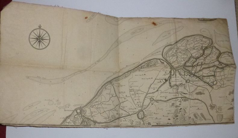
NICOLAS DE FER
Carte des environs de Bruges, D'ostende de l'Écluse. Extraite des frontières de France et des Pays-Bas. 1709.
Carte entoilée le titre de la partie supérieure à apparement été découpé. 31 x 62 cm. Deux traces de rouille incrustées sinon bon état.
書籍販売業者の参照番号
: 18666
|
|
|
Nice,Bruno.
Geografia economica dell'Europa.
<br/> TITOLO: Geografia economica dell'Europa. <br/> AUTORE: Nice,Bruno.<br/> EDITORE: ERI-Edizioni Rai Radiotelevisione Italiana<br/> DATA ED.: 1961,<br/> COLLANA: Coll.Classe Unica,124.<br/>
|
|
|
NICHOLSON Tim
The Birth of the Modern Ordnance Survey Small-Scale Map. The Revised New Series Colour Printed One-Inch Map of England and Wales 1897-1914. FINE COPY
8vo., First Edition, with coloured plates and monochrome illustrations in the text; printed wrappers, a near fine copy.

|
|
|
NICOLAS DE TRALAGE, J. (TILLEMON)
Description du Royaume de France Contenant ses principales Divisions G?ogaraphiques dress?es pour la grande Carte, intitul?e Le Royaume de France avec ses Acquisitions, &c
D?di?e ? Louis Le Grand, Avec une table alphab?tique de tous les noms qui sont sur cette carte pour les y trouver aisement 1 vol. 16.2x9.5 cm., [9] cc., 379, [4] pp., frontespizio inciso con scena allegorica, legatura coeva in piena pelle con, in francese Questa ? la parte descrittiva che accompagnava la carta del Royaume de France di NOLIN, Jean-Baptiste, (1648-1708), pubblicata nello stesso anno, come si deduce dall'opera stessa. La carta era dedicata al Re Luigi il grande, di cui lo stesso Nolin era cartografo ufficiale. Ottimo esemplare
|
|
|
NIGEL NICOLSON COLLECTIF
L'Himalaya.
Editions Time Life, les grandes étendues sauvages, 1980, bon état, in 4 couverture cartonnée dos et mors toilés, 184 pages de textes et photos.
書籍販売業者の参照番号
: 6493
|
|
|
Niles Douglas adventure design Tim Kilpin editing Ivor Janci graphic design Dave Laforce cartography Jeff Easley illus
RAIDERS OF THE LOST ARK ADVENTURE PACK
Hardcover. 0880381760 . TSR Inc.Lake Geneva IJ2 6751 copyright 1984 stapled wraps about 8�x11 laid in stiff folding jacket 32 pages Near Fine ISBN 0880381760 GAMES GAMING; E4562 . hardcover
書籍販売業者の参照番号
: 15323 ISBN : 0880381760 9780880381765
|
|
|
NISTRI Paolo Emilio -
Gli organi cartografici e l'imprenditoria privata nel settore del rilevamento topocartografico.
Firenze, 1998, 8vo stralcio con copertina posticcia muta, pp. 694/699. - !! ATTENZIONE !!: Con il termine estratto (o stralcio) intendiamo riferirci ad un fascicolo contenente un articolo, completo in se, sia che esso sia stato stampato a parte utilizzando la stessa composizione sia che provenga direttamente da una rivista. Le pagine sono indicate come "da/a", ad esempio: 229/231 significa che il testo è composto da tre pagine. Quando la rivista di provenienza non viene indicata é perché ci è sconosciuta. - !! ATTENTION !!: : NOT A BOOK : “extract” or “excerpt” means simply a few pages, original nonetheless, printed in a magazine. Pages are indicated as in "from” “to", for example: 229/231 means the text comprises three pages (229, 230 and 231). If the magazine that contained the pages is not mentioned, it is because it is unknown to us.

|
|
|
NIYAZI ÖZTÜRK (Tanzim eden), (Galata Veli Alemdar Han No: 16).
[EARLY REPUBLICAN MANUSCRIPT MAP of ANTHRACITE MINE in ZONGULDAK] Zonguldak ili Devrek ilçesine bagli Deli Ahmet Oglu Mah. Sabunlar Köyü Camisi, Çumu Camisi ile sinirlanmis olan saha içinde tas kömürü arama krokisi.
Very Good Turkish Original manuscript map on cloth. Chipped margins, stains on cloth. Folded. Oblong folio. (32x35 cm) In modern Turkish. Sealed. It shows the exploration of an area of ??1487 hectares and some stone and brick mosques, fountains, buildings and geographic status of the region in the upper corner. Scale: 1:25.000. Extremely rare.
|
|
|
NN
Plan Maritime & Commercial de la ville et du port d'Anvers offert par la Canadian Pacific Railway Company. Service direct d'Anvers vers le Canada et l'Extrême-Orient, départs tous les mercredis
Bruxelles, I. Khiat s.d. grand plan dépliant (125x84cm.) d'Anvers et son port, sous farde d'éditeur (22x16cm.), bon état, B93518
書籍販売業者の参照番号
: B93518
|
|
|
NN
Plan Maritime & Commercial de la ville et du port d'Anvers offert par la Canadian Pacific Railway Company. Service direct d'Anvers vers le Canada et l'Extrême-Orient, départs tous les mercredis
grand plan dépliant (125x84cm.) d'Anvers et son port, sous farde d'éditeur (22x16cm.), bon état, B93518
|
|
|
NOBENZAHL Kenneth
"Exploration des routes de la soie et au-delà; 2000 ans de cartographie."
Paris, Editions Phaidon, 2005. 30 x 26, 176 pp., très nombreuses cartes en couleurs, reliure d'édition pleine toile + jaquette, très bon état (sauf 1 cachet d'ex-propriétaire).
書籍販売業者の参照番号
: 90578 ISBN : 714894427
|
|
|
Nobile Umberto
L'Italia al Polo Nord
172 illustrazioni e grafici 2 carte fuori testo

|
|
|
Noble Wilford,John.
Cartografi. Precursori e innovatori da Tolomeo al satellite.
In un'opera di mole imponente ma di scorrevole lettura, Wilford ripercorre la storia della cartografia, dalle prime carte dell'antichità greco-romana alla lettura satellitare del territorio, passando per la lenta ma progressiva conquista di nuovi mondi e di nuove rotte. Seguiamo così le navi che fanno vela verso le coste del Nuovo Mondo sulla scorta delle prime carte nautiche della costa americana <br/> STATO: NUOVO.<br/> TITOLO: Cartografi. Precursori e innovatori da Tolomeo al satellite. <br/> AUTORE: Noble Wilford,John.<br/> CURATORE: Traduzione di Gianna Lonza.<br/> EDITORE: Ediz.Sylvestre Bonnard<br/> DATA ED.: 2005,<br/> COLLANA: Coll.Il Sapere del Libro.<br/> EAN: 9788889609040

|
|
|
Nodier Charles
La Seine et ses bords, par M. Ch. Nodier; illustrés de cinquante-quatre Gravures sur bois et de quatre cartes de la Seine. Publiés par M. Alex Mure de Pelanne
8°, mm 235x150, pp.192, brossura originale conservata all'interno di legatura in cartonato colorato con titolo su tassello al dorso, esemplare in barbe con sporadiche fioriture ai margini delle carte, completo delle 4 carte della Senna ripiegate e delle 42 tavole incise su acciaio fuori testo e 8 vignette nel testo. Edizione originale. ID 6447

|
|
|
NOEL THOMAS J. ; ZUBER MALLISON CAROL CARTOGRAPHY
Colorado: A Historical Atlas
University of Oklahoma Press Norman: 2019. Softcover. Brand new book. This is a thoroughly revised edition of the Historical Atlas of Colorado which was coauthored by Tom Noel and published in 1994. Chock-full of the best and latest information on Colorado this new edition features thirty new chapters updated text more than 100 color maps and 100 color photos and a best-of listing of Colorado authors and books as well as a guide to hundreds of tourist attractions. Colorado received its name Spanish for "red" after much debate and many possibilities including Idaho an "Indian" name meaning "gem of the mountains" later discovered to be a fabrication and Yampa Ute for "bear". Noel includes other little-known but significant facts about the state from its status as first state in the Union to elect women to its legislature to its controversial "highest state" designation elevated by the 2013 legalization of recreational cannabis. Noel and cartographer Carol Zuber-Mallison map and describe Colorado's spectacular geography and its fascinating past. The book's eight parts survey natural Colorado from rivers and mountains to dinosaurs and mammals; history from prehistoric peoples to twenty-first-century Color-oddities; mining and manufacturing from the gold rush to alternative energy sources; agriculture including wineries and brewpubs; transportation from stagecoach lines to light rail; modern Colorado from the New Deal to the present including politics history and information on lynchings executions and prisons; recreation covering not only hiking and skiing but also literary locales and Colorado in the movies; and tourism encompassing historic landmarks museums and even cemeteries. In short this book has information�and surprises�that anyone interested in Colorado will relish. 112 color maps 109 color illustrations 7 charts 1 table 12" x 9.5". Thomas J. Noel is Professor of History and Director of Public History Preservation and Colorado Studies at University of Colorado Denver. He appears regularly on Denver's Channel 9 NBC as "Dr. Colorado" writes a Sunday Denver Post column and is the author or coauthor of more than 40 books including Colorado: A History of the Centennial State coauthored with Carl Abbott and Steve Leonard and Colorado: A Liquid History and Tavern Guide to the Highest State. Carol Zuber-Mallison is an award-winning freelance artist specializing in maps and informational graphics. For 14 years she was an editor and artist for the Fort Worth Star-Telegram and the Dallas Morning News. She is also cartographer for the Texas Almanac. University of Oklahoma Press, Norman: 2019 paperback
書籍販売業者の参照番号
: 93538X1
|
|
|
NOLIN, I.B.:
Afrique selon les Relations les plus nouvelles. Dressée sur les memoires du S.r de Tillemont divisée en tous ses Royaumes et grands Etats avec un discour sur la nouvelle découverte de la situation des sources du Nil. (Carte geografique).
Paris, I.B. Nolin, 1743, 59 cm / 44.5 cm pts déchirures amarginales, coin sup.droite avec pt. manque, bruni et traces d’ usage, 1 feuille.
書籍販売業者の参照番号
: 101211aaf

|
|
|
Non identificato
SOLLIÈS PONT - CUERS / TOULON - HYÈ RES / S.t TROPEY - COLLOBIÈRES / CAP. BLANC - Î LES d'HYÈRES.
Grandissima carta topografica di cm. 131,7 x 83,5 perfettamente TELATA e in ottime condizioni, divisa in 32 rettangoli di cm. 20,8x16,3 editorialmente applicata alla tela grigia, e ripiegata a formare un oggetto di cm. 21x 16,5 x 2 di spessore. Impressa in bianco e nero, con bella evidenza dei rilievi, corsi d'acqua e laghi in azzurro, con indicazioni dei gradi ai bordi reticolo in nero e più piccolo in rosso. Parrebbe in scala 1:50.000 (cioè un cm. sulla carta equivale a 500 metri nella realtà).
|
|
|
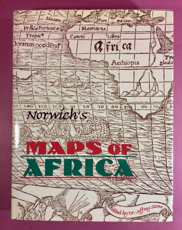
NORWICH, Oscar
Norwich's Maps of Africa.
1997 Couverture rigide Vermont, Terra nova press, 1997. In-4 (28,5x22cm), reliure entoilée de l'éditeur, jaquette illustrée. 408 pages, nombreuses reproductions en noir de cartes anciennes de l'Afrique, pages légèrement gondolées. Seconde édition de cet ouvrage de référence, paru pour la première fois en 1983. Bon exemplaire.
書籍販売業者の参照番号
: 1100
|
|
|
NORMAND Général Robert .
QUELQUES PASSAGES DU RHIN DANS L'HISTOIRE .
Editions Charles-Lavauzelle & Cie, Paris, Nancy, 1928, onze reproductions de cartes dépliantes hors texte, du XVIe au XIXe siècle, broché, 146pp. bon état +, 225x143 . (p4)
書籍販売業者の参照番号
: 6559
|
|
|
Nordenskiöld, A.E
Om bröderna zenos resor och de äldsta kartor öfver Norden.
Stockhom, Norstedt & Söner, 1883. M. 2 gefalt. Ktn. u. 2 Taf. im Anhang u. einigen im Text. 52 S. OBr. Ohne Umschl. Rücken m. Kleberest v. ehemaliger Bind. (Bihang till K. Svenska Vet. Akad. Handl. 8/2).
書籍販売業者の参照番号
: 150065
|
|
|
Norman James T. Philip Terry cartography by Donald T. Pitcher Dust Wrapper design by Larry Lurin
TERRY'S GUIDE TO MEXICO: A COMPLETELY REVISED EDITION OF T. PHILIP TERRY'S STANDARD GUIDEBOOK TO MEXICO
Garden City: Doubleday & Company Inc c.1965. Very Good in Good dust jacket. 1965. Later Printing. Hardcover. Presumed later printing thus no statement of printing code H22 on page 336. Oversize about7.25" x 10.5" volume 336 pages illustrated with maps including the endpapers glossary of useful Spanish words and phrases index. One corner lightly bumped some spot staining to upper fore-edge else Near Fine copy in price clipped else VG Dust Wrapper with some staining to the spine heel and some odd shallow chipping insect damage to the bottom of both flaps. . Doubleday & Company Inc [c.1965] hardcover
書籍販売業者の参照番号
: 29865

|
|
|
Norman James T. Philip Terry cartography by Donald T. Pitcher Dust Wrapper design by Larry Lurin
TERRY'S GUIDE TO MEXICO: A COMPLETELY REVISED EDITION OF T. PHILIP TERRY'S STANDARD GUIDEBOOK TO MEXICO
Garden City: Doubleday & Company Inc c.1965. Very Good in Very Good dust jacket. 1965. Later Printing. Hardcover. Presumed later printing thus no statement of printing code H22 on page 336. 336 pages illustrated including map endpapers index. VG copy spine ends bumped in price clipped Dust Wrapper with slight spine fading and some short edge tears. . Doubleday & Company Inc [c.1965] hardcover
書籍販売業者の参照番号
: 29777

|
|
|
Note illustrative su la carta geologica degli Altipiani Hararini e della Dancalia Meridionale.
GORTANI Michele - BIANCHI Angelo -
Bologna, 1941, 4to stralcio, pp. 89/104. Intonso. - !! ATTENZIONE !!: Con il termine estratto (o stralcio) intendiamo riferirci ad un fascicolo contenente un articolo, completo in se, sia che esso sia stato stampato a parte utilizzando la stessa composizione sia che provenga direttamente da una rivista. Le pagine sono indicate come "da/a", ad esempio: 229/231 significa che il testo è composto da tre pagine. Quando la rivista di provenienza non viene indicata é perché ci è sconosciuta. - !! ATTENTION !!: : NOT A BOOK : “extract” or “excerpt” means simply a few pages, original nonetheless, printed in a magazine. Pages are indicated as in "from” “to", for example: 229/231 means the text comprises three pages (229, 230 and 231). If the magazine that contained the pages is not mentioned, it is because it is unknown to us.

|
|
|
Nowell Charles E
A Letter to Ferdinand and Isabella 1503
Minneapolis: University of Minnesota Press 1965. Fine condition in a Fine clear plastic dust jacket. NO chips. NO tears. NO creases. Bright clean square and tight. Sharp corners. Hinges are perfect. Previous owner's bookplate on pastedown endpaper. NOT a library discard. Pages are fresh and crisp. A publication from the James Ford Bell Collection in the University of Minnesota Library. Limited to 750 numbered copies; this being #283. Translated from the Spanish with background essay and commentary by Charles E. Nowell. From the front matter: "Early in 1503 one Juan de Ayala recently of Hispaniola Haiti but then in Spain addressed a letter to his sovereigns Ferdinand and Isabella. Written in the rather difficult script of the early sixteenth century it consists of four pages of text to which are appended three more pages containing a price list of everyday goods imported from Spain as they then sold in Hispaniola. The main body of the letter contains a brief introduction and twenty-three paragraphs mostly short filled with complaints about the conditions on the island and suggestions for their reform. Ayala. asks the rulers to send him back there in a position of authority to make the changes." Two-tone binding brown boards and yellow cloth with printed paper spine label and decorative motif on the cover. Complete with clear plastic dust jacket. First Edition Limited to 750 copies. Hardcover. Fine condition/Fine dust jacket. 8vo. viii 93pp. Great Packaging Fast Shipping. University of Minnesota Press Hardcover
書籍販売業者の参照番号
: 019075
|
|
|
NOËL GUY
Rome.
Fernand Nathan, collection Pays et Cités d'Art, 1966, 160 pages, in 8 reliure cartonnée, exemplaire bibliothèque (tampons), état d'usage, charnière renforcée, coins et bords des plats frottés, traces d'emplacement (colle) de fiches bibliothèque sur les pages de garde.
書籍販売業者の参照番号
: 8332
|
|
|
NUOVA E CORRETTA CARTA DELL'ISOLA DI TERRA NUOVA ..
Tratta dal 'Gazzettiere Americano'.
Carta di cm 23 x 17,5 alla battuta, più i margini, incisa in rame da Veremondo Rossi. Ottimo esemplare, assai fresco.

|
|
|
OCEANIA (L') ..
Carta geografica dell'Autralia, Nuova Zelanda e arcipelago.
Carta geografica di cm. 34x26, all'immagine, più i margini. Raffig. dall'estremo sud della Cina a tutto l'arcipelago Polinesiano. Incisione in rame da G. C. castellini.

|
|
|
ODILE GAIL
La Chine.
Fernand Nathan, collection Pays et Cités d'Art, 1967, 160 pages, in 8 reliure cartonnée, exemplaire bibliothèque (tampons), état d'usage, charnière renforcée, coins et bords des plats frottés, traces d'emplacement (colle) de fiches bibliothèque sur les pages de garde.
書籍販売業者の参照番号
: 8331
|
|
|
Oehme, R
Die Geschichte d. Kartographie d. deutschen Südwestens.
Konstanz u. Stuttgart, Thorbecke, (1961). 4°. M. 16 Farbtaf. u. 42 s/w Ktn. 167 S. OLwd. M. Rsign. Einbd. leicht angestaubt. St. verso Tit. u. verso Taf. u. Ktn. Letzte Kte. m. geringem Randanriss. Hint. Vors. m. Sign.
書籍販売業者の参照番号
: 170066
|
|
 検索結果のメールを受信する
 PDFファイルの検索結果をダウンロード
 RSSフィード


