|
|
|
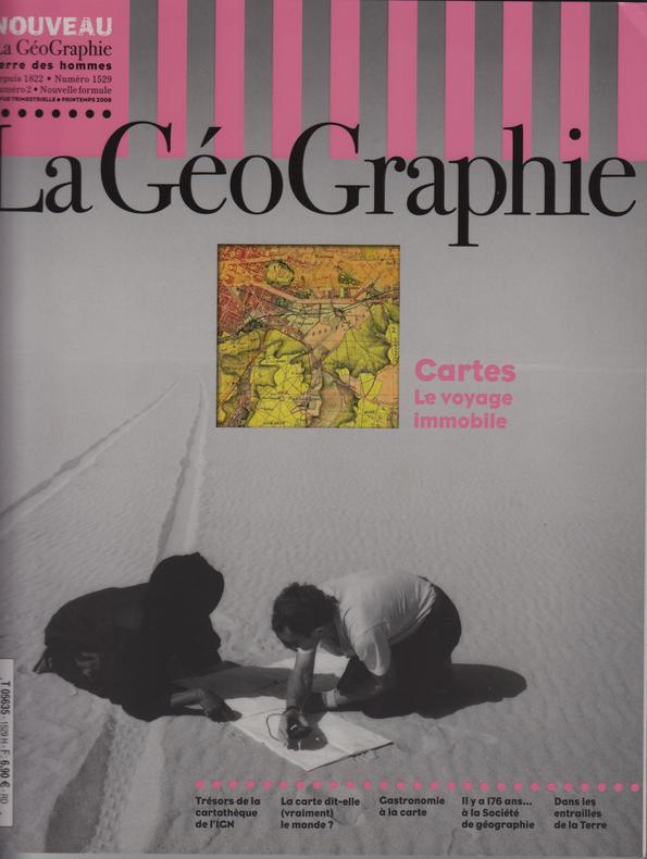
LA GEOGRAPHIE N°1529 (Printemps 2008)
CARTES : Le Voyage immobile.
Grenoble : Éditions Glénat, 2008. 113 pages abondamment illustrées en noir et couleur.
Référence libraire : SPN-288
|
|
|
LA RONCIERE, Monique de & MOLLAT DU JOURDIN, Michel:
Les portulans. Cartes marines du XIIIe au XVIIe siècle. Avec le concours de M(arie)-M(ad.) Azard, I(sabelle) Raynaud-Nguyen und M(arie)-A(nt.) Vannerau.
Fribourg, Office du Livre, 1984, gr. in-4°, 296 p., qqs ill. n/b et richement illustré de cartes en couleurs, reliure en toile originale, jaquette ill. en couleurs.
Référence libraire : 90515aaf
|
|
|
LA RONCIERE (Charles de)
Les Portulans de la Bibliothèque de Lyon. Documents paléographiques typographiques iconographiques, publiés sous la direction de Henry Joly, 8e fascicule.
Lyon, Les Amis de la Bibliothèque de Lyon, 1929. Petit in-4 carré, demi-chagrin havane, dos à nerfs titré, pièce de titre verte, tête dorée, couv. sup. conservée, 22 pp. de texte suivies de 14 planches in fine, dt 11 cartes sur double page (3 en couleurs). Tirage limité à 350 exemplaires plus les exemplaires sur vergé Montgolfier réservés aux membres de la Société. Celui-ci sur vergé filigrané "Incunable de Lyon".
Référence libraire : 563613

|
|
|
LA RONCIERE Monique de / LA MORANDIERE Charles de / ENGEL Claire-Eliane / VICHOT Jacques / BOUDRIOT Jean / NEYRET J.
NEPTUNIA.
Revue de l'Association des Amis du Musée de la Marine, numéro 90, 2e trimestre 1968, format 21x27cm, 40 pages+ supplément TRITON, numéro 85, bon état.
Référence libraire : 6559

|
|
|
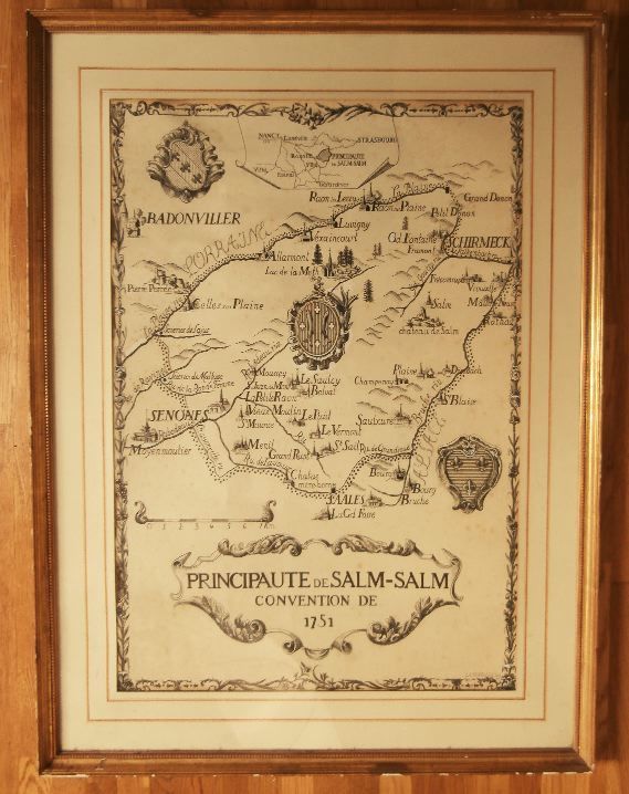
LA PERRIERE Françoise de
PRINCIPAUTÉ de SALM-SALM, Convention de 1751.
Carte historiée originale réalisé à l'encre de chine et quelques réhauts et retouches à la gouache blanche, son format à vue est de 730x505mm, montée sous cadre doré et vitré d'un format 910x690mm, signature et date ( 1965 ) en bas à droite, quelques rousseurs claires parsèment le dessin sinon l'état est très correct.Illustration réalisée pour l'ouvrage de Pierre de La Condamine " Une Principauté de Contes de Fées : Salm en Vosges " paru en 1965 chez Émile-Paul.
Référence libraire : 11983
|
|
|
LA DUCA ROSARIO
CARTOGRAFIA DELLA CITTA' DI PALERMO DALLE ORIGINI AL 1860.
4°, TELA EDITORIALE (SEGNI DEL TEMPO) CON TITOLO AL DORSO E AL PIATTO, RISGUARDI FIG., PG. 173 (3), NOTEVOLE APPARATO ICONOGRAFICO CON 63 ILL. B.N. E A COLORI PREVALENTEMENTE A PIENA PG. PIU' ALTRE FIG. NON NUMERATE, PRESENTAZIONE DI E. CARACCIOLO, BUONO STATO, IMPORTANTE TESTO DI RIFERIMENTO. PRIMA EDIZIONE.
|
|
|
LA GRAN BRETTAGNA ..
Carta incisa in rame e acquarellata a mano.
Carta di cm 38,5 x 48,5 alla battuta, più i margini, su tav. piegata a metà. Con i tragitti di alcune campagne militari, ed altre note storiche. Tratta da 'Atlante storico, geografico, genealogico, cronologico e letterario di M. A. Le Sage in ogni sua parte corretto, ampliato e proseguito sino all'anno corrente. Prima Veneta Edizione'.
|
|
|
La Sub Seccion de Cartografia Direccion General de Estadistica y Censos Republica de Honduras
Mapas de las Principales Poblaciones del Pais Republica de Honduras
Tegucigalpa Honduras: Secretaria de Economica y Hacienda Republica de Honduras 1963. Good 11"X 14" staple-bound paperback with yellowing to edges of wraps light soiling to wraps edgewear to wraps staple holes in front wrap traces of erased pencil in top corner of front wrap creased corners on wraps and soft creasing to corner tips of most pages in text block. Book has six-page introduction and 158 pages of maps. Trade Paperback. Good. 4to - over 9�" - 12" tall. Secretaria de Economica y Hacienda, Republica de Honduras Paperback
Référence libraire : 016870
|
|
|
LABEDOLLIERE, Emile de - Illustrations de Gustave Doré
Le Nouveau Paris : histoire de ses 20 arrondissements en 1860
1986 Ed. SACELP - 1986 - In-Folio, cartonnage toilé bordeaux sous jaquette illustrée en N&B - 440 p. - 21 cartes topographiques en couleurs dont une dépliante en fin d'ouvrage - 67 illustrations de Gustave Doré en N&B
Référence libraire : 103961
|
|
|
LACROIX, Louis-Antoine Nicolle de [abbé]
Géographie moderne, précédée d'un petit Traité de la sphère et du globe (---) et terminée par une géographie sacrée et une géographie ecclésiastique (---)par M. l'abbé Nicolle de La Croix. Nouvelle édition, revue par J.-L. Barbeau de La Bruyère. Paris. Delalain fils. An VIII [1799].
2 volumes in-12° reliés demi-basane marbrée, dos à nerfs décorés, petite fissure sur le dos du tome 1 avec accroc en coiffe supérieure, épidermures et traces de frottements sur les plats, coisn émoussés. LIV, 799 p. (ex-libris manuscrit, 3 cartes) - XVI, 849 p. (petites mouillures en début de volume). Bel état interne et d'ensemble sur ces volumes souvent en mauvais état.
Référence libraire : 25347

|
|
|
LAFRERI Antonio (Orgelet 1512 - Roma 1577)
Disegno dell’Isola di Malta con li porti et forti come al presente si vede cavato dalli disegni mandati da Malta et insiem
Acquaforte e bulino, 1565, firmata e datata in lastra nel cartiglio.Esemplare nel rarissimo secondo stato di tre. Magnifica prova, impressa su carta vergata coeva con filigrana “aquila nel cerchio con corona” (Woodward 55), rifilata al rame e con margini coevi aggiunti, in perfetto stato di conservazione. Magnifica mappa dell’isola di Malta, raffigurata durante l’assedio dell’armata Turca del giugno 1565. L’isola è interamente circondata da una flotta navale, e nel porto di Valletta sono disegnate le scene di guerra. La mappa è un secondo stato della lastra anonima, ma attribuita alla bottega di Lafrery, sempre edito nel giugno del 1565. La differenza è nel titolo e nel nome dell’editore aggiunto, e soprattutto nell’aggiunta del campo d’assedio delle truppe turche, posto nella parte meridionale di Valletta. L’opera ebbe una terza stesura, postuma, a cura di Pietro De’ Nobili, probabilmente per motivi commerciali data la bellezza della carta. Ganado suggerisce quale incisore della lastra Nicola Beatrizet, francese attivo a Roma.Magnifico esemplare.Le vicende dell’isola di Malta, della costruzione della città fortificata, la guerra contro i Turchi e il celebre assedio dell’isola costituiscono motivo di grande interesse nella civiltà rinascimentale europea, tanto da produrre una relativa cospicua letteratura e soprattutto una notevole produzione iconografica del susseguirsi degli eventi. Il Grande Assedio di Malta del 1565 rappresenta una pietra miliare nella storia delle isole maltesi, e anche un punto di svolta nella guerra tra i cristiani contro le forze dell'Impero Ottomano, conclusa con la celebre battaglia di Lepanto nel 1571. Nonostante queste due sconfitte catastrofiche, i Turchi continuarono a fare incursioni lungo le coste del Mediterraneo occidentale per il resto del secolo, dopo aver recuperato Cipro dai Veneziani e Tunisi dagli Spagnoli, ma il declino del loro impero era ormai annunciato. L'Assedio di Malta, che durò da maggio a settembre 1565, fu seguito con trepidazione non solo a Napoli, Roma e Venezia, ma anche a Vienna, Londra e Madrid, a Parigi, Anversa e Bruxelles. La notizia della lentezza degli assedianti e della disperata difesa dell'isola raggiunse la Sicilia attraverso le lettere scritte dal Gran Maestro Jean de La Valette- Parisot, bozzetti di battaglie spediti dai Cavalieri dell'Ordine di San Giovanni e Relationi, scritte da soldati o marinai. Scene e mappe dell’assedio furono realizzate in Francia, Germania, Spagna e Italia per raccontare in immagini le diverse fasi della strenua resistenza di Malta contro le forze armate della Mezzaluna. In Italia i principali centri di produzione furono Roma e Venezia. Dato la finalità essenzialmente informativa di questi lavori, gli acquirenti non sempre si curavano della loro conservazione, ragione per cui sono oggi di incredibile rarità. Albert Ganado, il maggiore esperto di cartografia maltese, elenca oltre 60 lavori cartografici sull’isola, nelle loro varie diverse ristampe, concentrati nel brevissimo spazio di soli 10 anni. Etching and engraving, 1565, signed and dated in the plate. Exemple in the rare second state of three. Magnificent proof, printed on contemporary laid paper with watermark "eagle in circle with crown" (Woodward 55), trimmed to the copperplate and with margins added, in a perfect state of preservation. Magnificent map of the island of Malta, represented the Turkish army during the siege in June 1565. The island is entirely surrounded by a naval fleet, and in the port of Valletta are drawn scenes of war. The map is a second state of the plate anonymous, but attributed to the workshop of Lafrery, also published in June 1565. The difference is in the title and name of the publisher added, and especially the addition of the field siege of the Turkish troops, located in the southern part of Valletta. The opera had a third issue, posthumously, edited by Pietro De 'Nobili, probably for commercial reasons given the beauty of the work. Ganado suggests as engraver of the plate Nicola Beatrizet, French, active in Rome.The history of the island of Malta, the construction of the walled city, the war against the Turks and the famous siege of the island, is a matter of great interest in European Renaissance culture, so as to produce a relatively large literature and above all a remarkable iconographic production of sequence of events. The year 1565 is a landmark in the history of the Maltese Islands. It was also a turning-point in the struggle of Christendom against the forces of the Ottoman Empire, on which the battle of Lepanto (1571) put the final seal. Despite these two disasters, the Turks continued to ravage the coasts of the western Mediterranean during the rest of the century, after having recovered Cyprus from the Venetians and Tunis from the Spaniards; but the decline of their empire was in sight. The siege of Malta, which lasted from May till September 1565, was watched with trepidation not only in Naples, Rome and Venice, but even in Vienna, London and Madrid, in Paris, Antwerp and Brussels. News of the slow progress of the besiegers and of the desperate defence of the island reached Sicily through letters written by Grand Master La Valette, battle-sketches despatched by the Knights of the Order of St. John and “Relationi” written by soldiers or seamen. Thence it spread fanlike to all the centers of Christendom stretching from the Iberian peninsula in the west to Hungary in the east. Picture-maps of the siege were produced in France, Germany, Spain and Italy to illustrate for the layman the stand being put up by Catholic Malta against the armed might of the Crescent, the main centers of production being Rome and Venice, which even turned out several editions of various broadsheets to bring up to date the latest developments in the bitter and uneven struggle. Albert Ganado, the major expert of Maltese cartography, clists over 60 maps on the island, in their various states, concentrated in a very short space of just 10 years. Ganado, A study in depth of 143 Maps representing the Great Siege of Malta of 1565, pp. 208/228, 47; Tooley, Italian Atlases, 360; Borroni Salvadori, Carte, piante e stampe storiche delle raccolte Lafreriane della Biblioteca nazionale di Firenze, 96.

|
|
|
LAFRERI Antonio (Orgelet 1512 - Roma 1577)
Gotlandia
La carta dell’isola di Gotland, nel Mar Baltico, appartiene per tipologia e formato al gruppo di carte dedicate alle isole pubblicate a Roma dal Lafreri.Acquaforte e bulino, stampata su carta vergata coeva con filigrana "Agnello pasquale" (Woodward 47-49), con margini originali aggiunti, bella coloritura antica, in ottimo stato di conservazione.Al centro dell’isola, con caratteri grandi, è inciso il titolo: GOTLANDIA. In alto a sinistra troviamo un cartiglio, senza nessuna iscrizione. Carta priva di scala grafica.Orientazione nei quattro lati al centro con la lettera iniziale dei quattro venti T[ramontana], O[Ostro], L[evante], P[onente], il nord è in alto. Graduazione ai margini di 15' in 15' solo nella latitudine,da 55° 39’ a 56° 12’. Acquaforte e bulino, dimensioni mm 256x190.Carta anonima dell’isola di Gotland, priva di data ed indicazioni editoriali, che spesso è confusa dalla letteratura con quella firmata da Ferrando Bertelli (Bifolco-Ronca, n. 249). Si tratta di una fedele replica della carta veneziana, e nelle raccolte cinquecentesche si trova quasi sempre stampata in coppia con l’anonima carta della Selandia. Per affinità stilistiche con tutta una serie di carte anonime delle isole, viene attribuita alla tipografia di Antonio Lafreri e datata intorno al 1570. Il foglio con le mappe delle due isole, appare anche nel catalogo del Lafreri, descritto come “Gotlandia et Zelandia Isole”. La lastra venne ereditata da Claudio Duchetti e quindi da Giacomo Gherardi. Possiamo identificare questa matrice con quella inserita nel catalogo della vedova di Giacomo Gherardi, Quintilia Lucidi (17-19 ottobre 1598, n. 167) dove è descritta come “isola gholandia”. Venne poi acquistata da Giovanni Orlandi (atto del 25 giugno 1602) e quindi da H. van Schoel. Sono dunque possibili, sebbene non note, tirature successive della carta.Altra bibliografia:Alberti (2010): n. 31; Christie’s (2012): n. 21; Edwards (1933): n. 27; Ganado (1994): VI, n. 21; Hatfield House (1992): n. 28; National Maritime Museum (1971): n. 29; Nordenskiöld (1981): n. 24; Ruge (1904-16): IV, n. 85.27 & 89.29; Valerio (2018): f. 60; Wieder (1915): p.8, n. 38; Alberti (2009): p. 199, n. 115; Pagani (2012): p. 84; Rubach (2016): n. 213; Tooley (1939): n. 267. Etching with engraving, printed on contemporary laid paper with "Lamb, Paschal with straight standard" watermark (Woodward 47-49), with original margins added, fine old colour, very good condition.Anonymous map of the island of Gotland, with no date and editorial indications, which is often confused by literature with that signed by Ferrando Bertelli (Bifolco-Ronca, No. 249). It is a faithful replica of the Venetian work, and in the sixteenth century collections it is almost always printed in pairs with the anonymous map of Selandia.For stylistic affinities with a whole series of anonymous maps of the islands, it is attributed to the typography of Antonio Lafreri and dated around 1570.The sheet with the maps of the two islands, also appears in the catalog of Antoni Lafreri, described as "Gotlandia et Zelandia Isole". The plate was inherited by Claudio Duchetti and then by Giacomo Gherardi. We can identify this work with that inserted in the catalog of the widow of Giacomo Gherardi, Quintilia Lucidi (17-19 October 1598, n ° 167) where it is described as "isola gholandia".It was then purchased by Giovanni Orlandi (act of 25 June 1602) and then by H. van Schoel. Therefore, subsequent issue of the plate, although not known, are possible.Literature:Alberti (2010): n. 31; Christie’s (2012): n. 21; Edwards (1933): n. 27; Ganado (1994): VI, n. 21; Hatfield House (1992): n. 28; National Maritime Museum (1971): n. 29; Nordenskiöld (1981): n. 24; Ruge (1904-16): IV, n. 85.27 & 89.29; Valerio (2018): f. 60; Wieder (1915): p.8, n. 38; Alberti (2009): p. 199, n. 115; Pagani (2012): p. 84; Rubach (2016): n. 213; Tooley (1939): n. 267. Bifolco-Ronca, Cartografia e Topografia Italiana del XVI secolo, Catalogo ragionato delle opera a stampa (2018), p. 737, tav. 250.

|
|
|
LAFRERI Antonio (Orgelet 1512 - Roma 1577)
IL dissegno della nobilissima Citta di GENOVA con il numero delle cose piu notabili di essa.
Magnifico esemplare del rarissimo secondo stato della pianta di Genova di Antonio Lafreri, con l'indirizzo di Paolo Graziani. La tiratura è databile tra il 1582 - anno in cui il Graziani acquista il rame dal nipote di Lafreri, Stefano Duchetti - e il 1585, anno in cuii entra in società con Pietro de Nobili.In basso a sinistra, in un riquadro, è inciso il titolo: IL dissegno della nobilissima Citta di GENOVA con il numero delle cose piu notabili di essa. Segue una legenda numerica di 58 rimandi a luoghi notabili della città. Sempre nel cartiglio si trova l’imprint editoriale: ROMAE apud Antonium Lafrerij Anno Domini MDLXXIII. Orientazione con una rosa dei venti nel mare, il nord è in alto. Opera priva di scala grafica. La pianta prospettica di Genova firmata da Antonio Lafreri introduce un nuovo modello iconografico della città, che è raffigurata attraverso una sovrapposizione di piani che non rende facile la lettura dell’impianto planimetrico. In questo l’autore segue ancora il modello iconografico della veduta quattrocentesca. Nel tentativo di rendere la carta più leggibile, tenta di riunire l’edificato in grandi lotti in modo da permettere l’identificazione di alcuni assi stradali strategici. Al contrario, molto ben delineata è la cinta muraria, aggiornata alla ristrutturazione ultimata intorno al 1549, su progetto di Antonio da Sangallo e Giovanni Maria Olgiati. Non sono presenti, invece, i palazzi di Galeazzo Alessi e di Giovan Battista Castello. Si può affermare che, a dispetto della datazione al 1573, la pianta del Lafreri raffiguri lo stato della città della metà del XVI secolo. Benevolo la descrive come “un compromesso, forse derivante da un’immagine più antica, fra una veduta marginale e una rudimentale proiezione obliqua dell’abitato, con il nord in alto”. La lastra è presente nel catalogo della tipografia Lafreri del 1573 (n. 130 descritta come “Genova”) e venne ereditata da Stefano Duchetti. Nell’inventario di vendita di Stefano (agosto 1581, n. 66) è descritta come “genova”. La ritroviamo nel catalogo di Paolo Graziani (settembre 1583, n. 56, come “Genova”) e quindi in quello di Pietro de Nobili (maggio 1585, n. 19, come “Genova”). Nella divisione ereditaria della tipografia de Nobili del 30 maggio 1589, fu assegnata al figlio Pietro Paolo e quindi ceduta a Giovan Battista de Cavalleris e Marcantonio Capriata. Sono note le ristampe di Paolo Graziani, databile al 1583-85 e già descritta da Alessia Alberti nel suo saggio su Lafreri, e quella con il doppio imprint di Graziani e de Nobili (1585-86). Alcuni repertori riportano che il nome di Paolo Graziani sia inciso sopra quello, abraso, di Claudio Duchetti, probabilmente per una confusione tra questa lastra con quella che il Duchetti fece intagliare da Ambrogio Brambilla nel 1581.BibliografiaAlberti (2010): n. 90; Brandhuber-Juffinger (2011); n. 49; Cartografia Rara (1986): n. 55; Destombes (1970): n. 71; Edwards (1933): n. 75; Phillips (1914): n. 75; Wieder (1915): n. 138; Alberti (2009): p. 102, n. 13; Benevolo (1969): pp. 64-67, tav. IX; Lincoln (2000): p. 185; Pagani (2008): pp. 15, 19, 374; Pagani (2011): p. 128, n. 66; Poleggi (1977): p. 74, n. 38, fig. 45; Rubach (2016): n. 227; Tooley (1939): n. 241. Magnificent example of the very rare second state of the Genoa plan by Antonio Lafreri, with the address of Paolo Graziani.On the lower left, the title: IL dissegno della nobilissima Citta di GENOVA con il numero delle cose piu notabili di essa. Segue una legenda numerica di 58 rimandi a luoghi notabili della città. Sempre nel cartiglio si trova l’imprint editoriale: ROMAE apud Antonium Lafrerij Anno Domini MDLXXIII.Orientation with a compass rose in the sea, the north is at the top; without graphic scale. Etching and engraving, dimensions mm 410x555.The perspective plan of Genoa signed by Antonio Lafreri introduces a new iconographic model of the city. "La pianta prospettica di Genova firmata da Antonio Lafreri introduce un nuovo modello iconografico della città, che è raffigurata attraverso una sovrapposizione di piani che non rende facile la lettura dell’impianto planimetrico. In questo l’autore segue ancora il modello iconografico della veduta quattrocentesca. Nel tentativo di rendere la carta più leggibile, tenta di riunire l’edificato in grandi lotti in modo da permettere l’identificazione di alcuni assi stradali strategici. Al contrario, molto ben delineata è la cinta muraria, aggiornata alla ristrutturazione ultimata intorno al 1549, su progetto di Antonio da Sangallo e Giovanni Maria Olgiati. Non sono presenti, invece, i palazzi di Galeazzo Alessi e di Giovan Battista Castello. Si può affermare che, a dispetto della datazione al 1573, la pianta del Lafreri raffiguri lo stato della città della metà del XVI secolo. Benevolo la descrive come “un compromesso, forse derivante da un’immagine più antica, fra una veduta marginale e una rudimentale proiezione obliqua dell’abitato, con il nord in alto”. La lastra è presente nel catalogo della tipografia Lafreri del 1573 (n. 130 descritta come “Genova”) e venne ereditata da Stefano Duchetti. Nell’inventario di vendita di Stefano (agosto 1581, n. 66) è descritta come “genova”. La ritroviamo nel catalogo di Paolo Graziani (settembre 1583, n. 56, come “Genova”) e quindi in quello di Pietro de Nobili (maggio 1585, n. 19, come “Genova”). Nella divisione ereditaria della tipografia de Nobili del 30 maggio 1589, fu assegnata al figlio Pietro Paolo e quindi ceduta a Giovan Battista de Cavalleris e Marcantonio Capriata. Sono note le ristampe di Paolo Graziani, databile al 1583-85 e già descritta da Alessia Alberti nel suo saggio su Lafreri, e quella con il doppio imprint di Graziani e de Nobili (1585-86). Alcuni repertori riportano che il nome di Paolo Graziani sia inciso sopra quello, abraso, di Claudio Duchetti, probabilmente per una confusione tra questa lastra con quella che il Duchetti fece intagliare da Ambrogio Brambilla nel 1581" (cf. Bifolco/Ronca, Cartografia e topografia italiana del XVI secolo, tav. 1110). LiteartureAlberti (2010): n. 90; Brandhuber-Juffinger (2011); n. 49; Cartografia Rara (1986): n. 55; Destombes (1970): n. 71; Edwards (1933): n. 75; Phillips (1914): n. 75; Wieder (1915): n. 138; Alberti (2009): p. 102, n. 13; Benevolo (1969): pp. 64-67, tav. IX; Lincoln (2000): p. 185; Pagani (2008): pp. 15, 19, 374; Pagani (2011): p. 128, n. 66; Poleggi (1977): p. 74, n. 38, fig. 45; Rubach (2016): n. 227; Tooley (1939): n. 241. Bifolco-Ronca (2018): tav. 1110, II/III.

|
|
|
LAFRERI Antonio (Orgelet 1512 - Roma 1577)
IL vero disegno dell’Jsola di Corfù…
Acquaforte e bulino, dimensioni mm 410x300, impressa su carta vergata coeva con filigrana "Corona a 5 punte, nel cerchio, con lettere AF" (Woodward 278-279), con margini originali, in perfetto stato di conservazione.Magnifco esemplare, nel secondo stato di tre (Cfr. Bifolco-Ronca, p. 1518) con l'inidrizzo di Giovanni Orlandi e la data 1602.Nel cartiglio in alto a destra si legge: IL vero disegno dell’Jsola di Corfù, nella quale per la sacra Lega è eretto l’Hospedale per ricever tutti i soldati christiani ammalati ò feriti nella presente santa impresa contra infideli, nel qualo è provisto de Medici fisici, e cirugici, et altri ministri per curarli et trattarli con ogni sorte di sovvertione et di charità. Orientazione fornita dal nome dei venti: TRAMONTANA, GRECO, LEVANTE, SIROCCO, OSTRO, LIBECCIO, PONENTE, MAESTRO, il nordovest è in basso. Carta priva di scala grafica e graduazione ai margini. Carta anonima, priva di data ed indicazioni editoriali nella sua prima stesura. La mappa è una fedele replica della carta veneziana di Forlani-Bertelli (1564) e viene attribuita da Zacharakis a Claudio Duchetti, per lapresenza della mappa è presente nell’atlante fattizio della National Library di Malta, in un gruppo di mappe recanti la sua firma. Se il luogo di stampa è certo, come dimostrano le successive tirature di Orlandi e van Schoel, ci sembra più pertinente l’attribuzione della lastra a Antonio Lafreri. Può essere identificata con l’opera descritta come “Isola di Corfu” (n. 57) nel catalogo della tipografia. La lastra venne ereditata da Claudio Duchetti e quindi da Giacomo Gherardi. Possiamo identificare questa matrice con “isola di Corfu” (n. 144) inserita nel catalogo della vedova di Giacomo Gherardi, Quintilia Lucidi, del 17-19 ottobre 1598 Venne poi acquistata da Giovanni Orlandi (atto del 25 giugno 1602) e quindi da H. van Schoel (1614).BibliografiaAlberti (2010): n. 56; Christie’s (2012): n. 37; Destombes (1970): n. 47; Edwards (1933): n. 47; Ganado (1994): VI, n. 45 & III, n. 148; Kinauer (1970): n. 55; Phillips (1914): n. 47; Shirley (1998): p. 42, n. 55; Valerio (2018): f. 90; Alberti (2009): p. 123, n. A.53; Pagani (2012): p. 84; Tolias (2011): n. 0699 & p. 94, tav. II.26; Tooley (1939): n. 163; Zacharakis (1992): n. 2149; Zacharakis (2009): nn. 1422-1423; Zacharakis (2016): n. 2483a. Etching with engraving, printed on contemporary laid paper with "Crown with five points in circle over AF" watermark (Woodward 278-279), with original margins, very good condition.A very rare second state of the plate, with the imprint of Giovanni Orlandi and the date 1602. According Bifolco-Ronca (cfr. p. 1518) the only other copy known in the public collection is at the Bibliothèque Nationale de France.Anonymous map, without date and editorial indications in its first edition. The map is a faithful replica of the Venetian map by Forlani-Bertelli (1564) and is attributed by Zacharakis to Claudio Duchetti, for thepresence in the six-volumes collection of the National Library of Malta, in a group of maps bearing his signature.If the place of printing is certain, as shown by the successive editions of Orlandi and van Schoel, the attribution of the plate to Antonio Lafreri seems more pertinent to us.It can be identified with the work described as "Isola di Corfu" (No. 57) in the Lafreri's catalog. The plate was inherited by Claudio Duchetti and then by Giacomo Gherardi. We can identify this work with "Isola di Corfu" (# 144) inserted in the catalog of the widow of Giacomo Gherardi, Quintilia Lucidi, of 17-19 October 1598.It was then purchased by Giovanni Orlandi (act of 25 June 1602) and then by H van Schoel (1614).Literature:Alberti (2010): n. 56; Christie’s (2012): n. 37; Destombes (1970): n. 47; Edwards (1933): n. 47; Ganado (1994): VI, n. 45 & III, n. 148; Kinauer (1970): n. 55; Phillips (1914): n. 47; Shirley (1998): p. 42, n. 55; Valerio (2018): f. 90; Alberti (2009): p. 123, n. A.53; Pagani (2012): p. 84; Tolias (2011): n. 0699 & p. 94, tav. II.26; Tooley (1939): n. 163; Zacharakis (1992): n. 2149; Zacharakis (2009): nn. 1422-1423; Zacharakis (2016): n. 2483a. Bifolco-Ronca, Cartografia e Topografia Italiana del XVI secolo, Catalogo ragionato delle opera a stampa (2018), p. 1518, tav. 730, secondo stato di tre.

|
|
|
LAFRERI Antonio (Orgelet 1512 - Roma 1577)
Il vero ritratto di Nettuno al presente occupato dagl'imperiali
In alto al centro, in un riquadro, il titolo: IL VERO RITRATTO DI NETTUNO al presente occupato da gl’inperiali. In basso al centro la data 1557. Orientazione nei quattro lati al centro con il nome dei venti: TRAMONTANA, MEZZO DI, LEVANTE, PONENTE, il nord è in basso. Acquaforte e bulino, stampata su carta vergata coeva, con margini, in ottimo stato di conservazione. Esemplare nel quarto stato di cinque, con l’indirizzo di Hendrick van Schoel. Carta anonima e priva di indicazioni editoriali – nelle sue prime stesure - datata 1557. La mappa, sebbene incentrata sulla città di Nettuno, rappresentata molto ingrandita e fuori scala, descrive la parte meridionale del Lazio fino al Monte Circeo e alle Paludi Pontine. L’opera fu realizzata in occasione della cosiddetta Guerra del Sale (1556-57), quando le armate del viceré di Napoli, il duca d’Alba, invasero la parte meridionale dello Stato Pontificio. Destombes attribuisce la lastra alla tipografia di Antonio Lafreri; l’opera è elencata nel catalogo dell’editore (n. 81, come “Nettuno”). Tuttavia, è altresì possibile che si tratti di una lastra prodotta da Antonio Salamanca che confluì nel catalogo dopo la fusione delle due tipografie. Della carta è conosciuta una prova di stampa, con la sola città di Nettuno delineata, conservata nella biblioteca di Dillingen. Il secondo stato della lastra è quello terminato che si trova in diverse raccolte fattizie cinquecentesche; infine, l’opera fu ristampata nel 1602 da Giovanni Orlandi e successivamente da Hendrick van Schoel dopo il 1614. Molto rara. Bibliografia Bifolco-Ronca, Cartografia e topografia italiana del XVI secolo, 2018, pp. 2260-2261, tav. 1160, IV/V; Alberti (2010): n. 86; Brandhuber-Juffinger (2011); n. 98; Borroni Salvadori (1980): n. 219; Christie’s (1998): n. 1050; Destombes (1970): nn. 82-82a; Edwards (1933): n. 69; Kinauer (1970): 68; Ganado (1994): III, n. 192 & p. 213, n. 64; Hatfield House (1992): n. 84; Nordenskiöld (1981): n. 71; Phillips (1914): n. 70; Ruge (1904-16): IV, 90.94; Shirley (2004): III, n. 43; Alberti (2009): p. 128, n. A.78; Marigliani (2005): p. 90; Marigliani (2016): n. XI.11; Pagani (2017): p. 47, C02 e p. 52; Pognon (1968): p. 15; Tooley (1939): nn. 417-418. In the upper center, in the cartouche, the title: IL VERO RITRATTO DI NETTUNO al presente occupato da gl’inperiali. Lower center the date 1557. Orientation given on the four sides, in the center, with the name of the winds: TRAMONTANA, HALF OF, LEVANTE, PONENTE; the North is at the bottom. Etching and engraving, printed on contemporary laid paper, with margins, in excellent condition. Exemple in the fourth state, of five, with the address of Hendrick van Schoel. Anonymous map without editorial indications - in its first drafts - dated 1557. The map, although centered on the city of Neptune, represented much enlarged and out of scale, describes the southern part of Lazio up to Monte Circeo and the Pontine Marshes. The work was produced on the occasion of the so-called Salt War (1556-57), when the armies of the viceroy of Naples, the Duke of Alba, invaded the southern part of the Papal States. Destombes attributes the plate to the printing house of Antonio Lafreri; the work is listed in the publisher's catalog (no. 81, as "Neptune"). However, it is also possible that this is a plate produced by Antonio Salamanca, whose plates merged into the Lafreri catalog after the union of the two printers. A proof of the plate is known, with only the city of Neptune outlined, preserved in the library of Dillingen. The second state of the plate, finished, is found in several sixteenth-century factitious collections; finally, the work was reprinted in 1602 by Giovanni Orlandi and then by Hendrick van Schoel after 1614. Extremely rare. References: Bifolco-Ronca, Cartografia e topografia italiana del XVI secolo, 2018, pp. 2260-2261, tav. 1160, IV/V; Alberti (2010): n. 86; Brandhuber-Juffinger (2011); n. 98; Borroni Salvadori (1980): n. 219; Christie’s (1998): n. 1050; Destombes (1970): nn. 82-82a; Edwards (1933): n. 69; Kinauer (1970): 68; Ganado (1994): III, n. 192 & p. 213, n. 64; Hatfield House (1992): n. 84; Nordenskiöld (1981): n. 71; Phillips (1914): n. 70; Ruge (1904-16): IV, 90.94; Shirley (2004): III, n. 43; Alberti (2009): p. 128, n. A.78; Marigliani (2005): p. 90; Marigliani (2016): n. XI.11; Pagani (2017): p. 47, C02 e p. 52; Pognon (1968): p. 15; Tooley (1939): nn. 417-418.

|
|
|
LAFRERI Antonio (Orgelet 1512 - Roma 1577)
La Fortezza et Pianta della Goletta
UNICO ESEMPLARE CONOSCIUTO In alto, lungo il bordo superiore, è inciso il titolo: LA FORTEZZA ET PIANTA DELLA GOLETTA. Orientazione fornita da una rosa dei venti, con il nord-nord-est a destra. In basso a sinistra è rappresentala scala grafica Canne cento napoletane (100 canne, pari a mm 77). Nel lato sinistro troviamo La parte di radis, nel lato destro La parte che va a torre del aque et Cartagine. Si tratta di una prova di stampa, o di uno stato antecedente, della pianta di Goletta pubblicata per la prima volta in Bifolco-Ronca (cfr. Cartografia e topografia italiana del XVI secolo, 2018, p. 547, tav. 160): “Nella collezione cartografica della Universitatsbibliothek di Salisburgo è presente questa ulteriore variante della pianta della città fortificata di La Goletta. Si tratta di opera anonima, priva di data ed indicazioni editoriali, molto simile a quella descritta in precedenza ed attribuita ad Antonio Lafreri”. “Nel 1573 don Giovanni d’Austria riconquistava Tunisi e Goletta, lasciando a Tunisi una guarnigione di 8.000 uomini, spagnoli e italiani, al comando di Serbelloni. Si decise, allora, di costruire una fortezza a Tunisi e di intervenire su quella della Goletta Vecchia. Le due fortezze, tuttavia, vennero riconquistate dai turchi nell’agosto del 1574, dopo un mese di assedio. Lo stesso Serbelloni fu fatto prigioniero e tratto a Costantinopoli. Nel 1575, dopo la prigionia, scrisse una Relatione degli Successi della Goletta e Tunisi, al fine di giustificare il proprio operato, che fu edito nel 1577 nella raccolta Lettere di Principi curata da Girolamo Ruscelli. […] La lastra viene attribuita alla tipografia di Antonio Lafreri, per la presenza nel catalogo del 1573 di “Diuerse carte di Tunisi et la Goletta”. Nell’inventario di Stefano Duchetti è indicata come “Il forte de Tunis”, mentre in quello di Pietro de Nobili come “Pianta della fortezza di Tunisi”. Sono possibili quindi, sebbene non conosciute, delle ristampe successive della lastra.” (cfr. Bifolco-Ronca, Cartografia e topografia italiana del XVI secolo, p. 542). La differenza è che il nostro esemplare, a differenza di quello della Universitatsbibliothek di Salisburgo, non raffigura la cittadella sotto assedio. Realizzata probabilmente nel 1573, anno in cui le mura di Goletta vennero fortificate su progetto del comandante e ingegnere militare Gabrio Serbelloni. Lo stato con l’assedio invece deve risalire al 1574. Acquaforte e bulino, impressa su carta vergata coeva, con margini, in eccellente stato di conservazione. Opera rarissima, unico esemplare conosciuto e mai pubblicato, già nella collezione di Fritz Hellwig. Bibliografia Bifolco-Ronca, Cartografia e topografia italiana del XVI secolo, p. 547, tav. 160 (secondo stato, con l’assedio). THE ONLY KNOWN EXAMPLE At the top, along the upper edge, is engraved the title: LA FORTEZZA ET PIANTA DELLA GOLETTA. Orientation provided by a wind rose, with north-northeast on the right. At lower left is represented by the graphic scale Canne cento napoletane (100 canes, equal to 77 mm). In the left side we find La parte di radis, in the right side La parte che va a torre del aque et Cartagine. This is a print proof, or an earlier state, of the plan of Goletta published for the first time in Bifolco-Ronca (cf. Cartografia e topografia italiana del XVI secolo, 2018, p. 547, tav. 160): "In the cartographic collection of the Universitatsbibliothek in Salzburg there is this further variant of the plan of the fortified town of La Goletta. It is an anonymous work, without date and editorial indications, very similar to the one described above and attributed to Antonio Lafreri". "In 1573 Don Giovanni of Austria reconquered Tunis and La Goletta, leaving in Tunis a garrison of 8,000 men, Spanish and Italian, under the command of Serbelloni. It was decided, then, to build a fortress in Tunis and to intervene on the one in Goletta Vecchia. The two fortresses, however, were reconquered by the Turks in August 1574, after a month of siege. Serbelloni himself was made prisoner and taken to Constantinople. In 1575, after his imprisonment, he wrote a Relatione degli Successi della Goletta e Tunisi, in order to justify his work, which was published in 1577 in the collection Lettere di Principi edited by Girolamo Ruscelli. [...] The plate is attributed to the typography of Antonio Lafreri, due to the presence in the 1573 catalog of "Diuerse carte di Tunisi et la Goletta". In the inventory of Stefano Duchetti, it is indicated as "Il forte de Tunis", while in that of Pietro de Nobili as "Pianta della fortezza di Tunisi". Therefore, although not known, subsequent reprints of the plate are possible." (cf. Bifolco-Ronca, Cartografia e topografia italiana del XVI secolo, p. 542). The difference is that our exemplar, unlike the one in the Universitatsbibliothek of Salzburg, does not depict the citadel under siege. It was probably built in 1573, the year in which the walls of Goletta were fortified according to the project of the commander and military engineer Gabrio Serbelloni. The state with the siege instead must date back to 1574. Etching and engraving, printed on contemporary blank paper, with margins, in excellent condition. Very rare work, the only known and never published copy, already in the collection of Fritz Hellwig. Literature Bifolco-Ronca, Cartografia e topografia italiana del XVI secolo, p. 547, tav. 160 (second state, with the siege).

|
|
|
LAFRERI Antonio (Orgelet 1512 - Roma 1577)
Li porti dell’Isola di Malta con la Pianta della nova Cittade dove habiteranno quelli che stanno hora nel Borgo qui disegn
Acquaforte e bulino, 1563, datata in lastra in basso a destra. Magnifica prova, impressa su carta vergata coeva con filigrana “aquila nel cerchio con corona” (Woodward 55), rifilata al rame e con margini coevi aggiunti, in perfetto stato di conservazione. Prima rappresentazione a stampa del porto di Valletta, stampata a Roma e probabilmente opera della tipografia Salamanca & Lafrery, nel periodo in cui il Lafrery collaborava con il figlio di Antonio Salamanca, Francesco. L’opera è basata sul manoscritto di Bartolomeo Genga del 1558, il progetto originale per la città fortificata. Della mappa venne subito realizzata una replica a Venezia nello stesso anno e successivamente fu il prototipo di diverse mappe dell’assedio del 1565 di Zenoi, Lafrery stesso e Glaser. Nel 1566 il Lafrery usò la lastra e la aggiornò cambiando il disegno della cittadella fortificata che seguiva il progetto di Genga ed aggiornandolo con quello di Francesco Laparelli. Rarissima prima pianta del porto di Valletta.Le vicende dell’isola di Malta, della costruzione della città fortificata, la guerra contro i Turchi e il celebre assedio dell’isola costituiscono motivo di grande interesse nella civiltà rinascimentale europea, tanto da produrre una relativa cospicua letteratura e soprattutto una notevole produzione iconografica del susseguirsi degli eventi. Il Grande Assedio di Malta del 1565 rappresenta una pietra miliare nella storia delle isole maltesi, e anche un punto di svolta nella guerra tra i cristiani contro le forze dell'Impero Ottomano, conclusa con la celebre battaglia di Lepanto nel 1571. Nonostante queste due sconfitte catastrofiche, i Turchi continuarono a fare incursioni lungo le coste del Mediterraneo occidentale per il resto del secolo, dopo aver recuperato Cipro dai Veneziani e Tunisi dagli Spagnoli, ma il declino del loro impero era ormai annunciato. L'Assedio di Malta, che durò da maggio a settembre 1565, fu seguito con trepidazione non solo a Napoli, Roma e Venezia, ma anche a Vienna, Londra e Madrid, a Parigi, Anversa e Bruxelles. La notizia della lentezza degli assedianti e della disperata difesa dell'isola raggiunse la Sicilia attraverso le lettere scritte dal Gran Maestro Jean de La Valette- Parisot, bozzetti di battaglie spediti dai Cavalieri dell'Ordine di San Giovanni e Relationi, scritte da soldati o marinai. Scene e mappe dell’assedio furono realizzate in Francia, Germania, Spagna e Italia per raccontare in immagini le diverse fasi della strenua resistenza di Malta contro le forze armate della Mezzaluna. In Italia i principali centri di produzione furono Roma e Venezia. Dato la finalità essenzialmente informativa di questi lavori, gli acquirenti non sempre si curavano della loro conservazione, ragione per cui sono oggi di incredibile rarità. Albert Ganado, il maggiore esperto di cartografia maltese, elenca oltre 60 lavori cartografici sull’isola, nelle loro varie diverse ristampe, concentrati nel brevissimo spazio di soli 10 anni. - THE FIRST MAP OF VALLETTA - Etching and engraving, 1563 dated in the plate lower right. Magnificent proof, printed on contemporary laid paper with watermark "eagle in circle with crown" (Woodward 55), trimmed to the copperplate and with margins added, in a perfect state of preservation.First printed representation of the port of Valletta, printed in Rome and probably the work of typography & Lafrery Salamanca, in the period in which the Lafrery collaborated with the son of Antonio Salamanca, Francis. The opera is based on the manuscript by Bartolomeo Genga 1558, the original plan for the walled city. Map was immediately made a replica in Venice in the same year and later was the prototype of different maps of the siege of 1565 Zenoi, Lafrery itself and Glaser. In 1566 Lafrery used the plate and adjourned changing the design of the fortified citadel that followed the project Genga and upgrading with that of Francesco Laparelli. Very rare first map in the port of Valletta. The history of the island of Malta, the construction of the walled city, the war against the Turks and the famous siege of the island, is a matter of great interest in European Renaissance culture, so as to produce a relatively large literature and above all a remarkable iconographic production of sequence of events. The year 1565 is a landmark in the history of the Maltese Islands. It was also a turning-point in the struggle of Christendom against the forces of the Ottoman Empire, on which the battle of Lepanto (1571) put the final seal. Despite these two disasters, the Turks continued to ravage the coasts of the western Mediterranean during the rest of the century, after having recovered Cyprus from the Venetians and Tunis from the Spaniards; but the decline of their empire was in sight. The siege of Malta, which lasted from May till September 1565, was watched with trepidation not only in Naples, Rome and Venice, but even in Vienna, London and Madrid, in Paris, Antwerp and Brussels. News of the slow progress of the besiegers and of the desperate defence of the island reached Sicily through letters written by Grand Master La Valette, battle-sketches despatched by the Knights of the Order of St. John and “Relationi” written by soldiers or seamen. Thence it spread fanlike to all the centers of Christendom stretching from the Iberian peninsula in the west to Hungary in the east. Picture-maps of the siege were produced in France, Germany, Spain and Italy to illustrate for the layman the stand being put up by Catholic Malta against the armed might of the Crescent, the main centers of production being Rome and Venice, which even turned out several editions of various broadsheets to bring up to date the latest developments in the bitter and uneven struggle. Albert Ganado, the major expert of Maltese cartography, clists over 60 maps on the island, in their various states, concentrated in a very short space of just 10 years. Ganado, Valletta Città Nuova, A Map History (1566-1600), pp366-8, 14; Ganado, A study in depth of 143 Maps representing the Great Siege of Malta of 1565.

|
|
|
LAFRERI Antonio (Orgelet 1512 - Roma 1577)
Nuovo disegno dell’Isola di Malta et suoi forti Con li Isola di Comino, Gozo et altre Isole vicine.
Acquaforte e bulino, 1565, firmata e datata in lastra nel cartiglio. Esemplare nel rarissimo primo stato di quattro. Magnifica prova, impressa su carta vergata coeva con “giglio nel cerchio” (Woodward 97), rifilata al rame e con margini coevi aggiunti, in perfetto stato di conservazione. Mappa dell’arcipelago maltese con le coste settentrionali dell’Africa, parte della Sicilia e della Sardegna. L’isola di Malta è rappresentata fuori scala, molto più grande del resto delle altre zone incluse, probabilmente rappresentate solo per inquadrare la posizione geografica dell’isola. L’opera è datata da Ganado tra la fine di settembre ed ottobre del 1565; l’isola è presidiata da numerose barche, tutte con il simbolo della croce cristiana, a dimostrazione della fine dell’assedio turco. La forma geografica dell’isola segue un modello del settembre 1565, un’anonima mappa edita a Roma dalla tipografia Palombi, a S. Agostino a linsegna della Palomba (Ganado 23).Le vicende dell’isola di Malta, della costruzione della città fortificata, la guerra contro i Turchi e il celebre assedio dell’isola costituiscono motivo di grande interesse nella civiltà rinascimentale europea, tanto da produrre una relativa cospicua letteratura e soprattutto una notevole produzione iconografica del susseguirsi degli eventi. Il Grande Assedio di Malta del 1565 rappresenta una pietra miliare nella storia delle isole maltesi, e anche un punto di svolta nella guerra tra i cristiani contro le forze dell'Impero Ottomano, conclusa con la celebre battaglia di Lepanto nel 1571. Nonostante queste due sconfitte catastrofiche, i Turchi continuarono a fare incursioni lungo le coste del Mediterraneo occidentale per il resto del secolo, dopo aver recuperato Cipro dai Veneziani e Tunisi dagli Spagnoli, ma il declino del loro impero era ormai annunciato. L'Assedio di Malta, che durò da maggio a settembre 1565, fu seguito con trepidazione non solo a Napoli, Roma e Venezia, ma anche a Vienna, Londra e Madrid, a Parigi, Anversa e Bruxelles. La notizia della lentezza degli assedianti e della disperata difesa dell'isola raggiunse la Sicilia attraverso le lettere scritte dal Gran Maestro Jean de La Valette- Parisot, bozzetti di battaglie spediti dai Cavalieri dell'Ordine di San Giovanni e Relationi, scritte da soldati o marinai. Scene e mappe dell’assedio furono realizzate in Francia, Germania, Spagna e Italia per raccontare in immagini le diverse fasi della strenua resistenza di Malta contro le forze armate della Mezzaluna. In Italia i principali centri di produzione furono Roma e Venezia. Dato la finalità essenzialmente informativa di questi lavori, gli acquirenti non sempre si curavano della loro conservazione, ragione per cui sono oggi di incredibile rarità. Albert Ganado, il maggiore esperto di cartografia maltese, elenca oltre 60 lavori cartografici sull’isola, nelle loro varie diverse ristampe, concentrati nel brevissimo spazio di soli 10 anni. Etching and engraving, 1565, signed and dated in the plate. Example in very rare first state of four. Magnificent proof, printed on contemporary laid paper with "lily in the circle" watermark (Woodward 97), trimmed to the copperplate and with margins added, in a perfect state of preservation. Map of the Maltese archipelago with the northern coasts of Africa, part of Sicily and Sardinia. The island of Malta is represented out of scale, much larger than the rest of the other areas including, probably represented only to frame the geographical position of the island. The work is dated from Ganado between the end of September and October of 1565, the island is guarded by many boats, all with the symbol of the Christian cross, showing the end of the siege. The geographical shape of the island follows a pattern of September 1565, an anonymous map published in Rome by the publisher Palombi (Ganado 23).The history of the island of Malta, the construction of the walled city, the war against the Turks and the famous siege of the island, is a matter of great interest in European Renaissance culture, so as to produce a relatively large literature and above all a remarkable iconographic production of sequence of events. The year 1565 is a landmark in the history of the Maltese Islands. It was also a turning-point in the struggle of Christendom against the forces of the Ottoman Empire, on which the battle of Lepanto (1571) put the final seal. Despite these two disasters, the Turks continued to ravage the coasts of the western Mediterranean during the rest of the century, after having recovered Cyprus from the Venetians and Tunis from the Spaniards; but the decline of their empire was in sight. The siege of Malta, which lasted from May till September 1565, was watched with trepidation not only in Naples, Rome and Venice, but even in Vienna, London and Madrid, in Paris, Antwerp and Brussels. News of the slow progress of the besiegers and of the desperate defence of the island reached Sicily through letters written by Grand Master La Valette, battle-sketches despatched by the Knights of the Order of St. John and “Relationi” written by soldiers or seamen. Thence it spread fanlike to all the centers of Christendom stretching from the Iberian peninsula in the west to Hungary in the east. Picture-maps of the siege were produced in France, Germany, Spain and Italy to illustrate for the layman the stand being put up by Catholic Malta against the armed might of the Crescent, the main centers of production being Rome and Venice, which even turned out several editions of various broadsheets to bring up to date the latest developments in the bitter and uneven struggle. Albert Ganado, the major expert of Maltese cartography, clists over 60 maps on the island, in their various states, concentrated in a very short space of just 10 years. Ganado, A study in depth of 143 Maps representing the Great Siege of Malta of 1565, pp. 257/261, 56; Tooley, Italian Atlases, 377; Borroni Salvadori, Carte, piante e stampe storiche delle raccolte Lafreriane della Biblioteca nazionale di Firenze, 104.

|
|
|
LAFRERI Antonio (Orgelet 1512 - Roma 1577)
Regionis subalpinae vulgo Piemonte appellatae discriptio, aeneis nostris formis excussa
Importante carta geografica del Piemonte, impressa su singolo foglio reale, per la prima volta stampata a Roma dal Lafrery nel 1560 circa, qui nella successiva ristampa a cura di Petro de’ Nobili, databile all’ultimo decennio del XVI secolo. L’attribuzione alla paternità dell’opera si deve a Roberto Almagià, seguito poi dal Tooley. Sebbene non sia certo quale sia la prima carta a stampa della regione (Perini sostiene che questa derivi da un’anonima carta veneta del 1553), questo lavoro può essere definito come il primo vero rilievo della sola regione, con particolare attenzione per la zona alpina. Orientata con il nord in alto, la carta presenta una toponomastica particolarmente ricca. Della carta esiste un secondo stato con la data aggiunta, 1564; pertanto questo con l’indirizzo di Pietro de Nobili può essere considerato come il terzo, definitivo, stato della mappa. Incisione in rame, in buone condizioni. Pubblicata nel L’Italia e le sue regioni nella bottega dell’incisore, a cura di Vladimiro Valerio, pag. 34, tav. 8. Almagià XVIII; Tooley 446; Perini p. 43. Interesting geographic map of Piedmont, printed on a single large sheet, published for the first time in Rome by Lafrery around 1560, here presented in the second edition published by Petro de’ Nobili at end of the XVI century. The attribution of this work is due to Roberto Almagià, followed afterwards by Tooley. Though it is not the first printed map of the region (Perini states it derives from an anonymous Venetian map of 1553), this work can be defined as the first analysis concerning uniquely the Piedmont, particularly the Alps. Oriented from North to South, the map presents many toponyms. A second state, bearing the date 1564, is known; therefore, the present one with the address of Pietro de Nobili can be considered as the third, final state of the map. Copper engraving, in excellent condition. Published inside the L’Italia e le sue regioni in the artits’ workshop, edited by Vladimiro Valerio, pag. 34, tav. 8. Almagià XVIII; Tooley 446; Perini p. 43.

|
|
|
LAFRERI Antonio (Orgelet 1512 - Roma 1577)
Ultimo disegno delli forti di Malta venuto nuovamente..
Acquaforte e bulino, 1565, firmata e datata in lastra nel cartiglio. Esemplare nel rarissimo primo stato di quattro. Magnifica prova, impressa su carta vergata coeva con filigrana “aquila nel cerchio con corona” (Woodward 55), rifilata al rame e con margini coevi aggiunti, in perfetto stato di conservazione. Pianta dell’assedio del 1565 a La Valletta, realizzata nell’agosto del 1565, come dichiarato nel cartiglio Ant. Lafrej Romae formis 1565 de mese Augusti. Della lastra esiste un secondo stato sempre edito nell’agosto del 1565, un aggiornamento costituito da nuove informazioni giunte al Lafrery che parlava della costruzione di un ponte di barche all’interno di Dockyard Creek. Il primo stato della lastra quindi ebbe una bassissima tiratura ed è pertanto rarissimo, ne sono conosciuti solo 10 esemplari nelle raccolte lafreriane. La mappa, forse per la sua incredibile bellezza, ebbe due tirature successive curate a Giovanni Orlandi diversi decenni dopo. Meraviglioso esemplare di questo importante documento.Le vicende dell’isola di Malta, della costruzione della città fortificata, la guerra contro i Turchi e il celebre assedio dell’isola costituiscono motivo di grande interesse nella civiltà rinascimentale europea, tanto da produrre una relativa cospicua letteratura e soprattutto una notevole produzione iconografica del susseguirsi degli eventi. Il Grande Assedio di Malta del 1565 rappresenta una pietra miliare nella storia delle isole maltesi, e anche un punto di svolta nella guerra tra i cristiani contro le forze dell'Impero Ottomano, conclusa con la celebre battaglia di Lepanto nel 1571. Nonostante queste due sconfitte catastrofiche, i Turchi continuarono a fare incursioni lungo le coste del Mediterraneo occidentale per il resto del secolo, dopo aver recuperato Cipro dai Veneziani e Tunisi dagli Spagnoli, ma il declino del loro impero era ormai annunciato. L'Assedio di Malta, che durò da maggio a settembre 1565, fu seguito con trepidazione non solo a Napoli, Roma e Venezia, ma anche a Vienna, Londra e Madrid, a Parigi, Anversa e Bruxelles. La notizia della lentezza degli assedianti e della disperata difesa dell'isola raggiunse la Sicilia attraverso le lettere scritte dal Gran Maestro Jean de La Valette- Parisot, bozzetti di battaglie spediti dai Cavalieri dell'Ordine di San Giovanni e Relationi, scritte da soldati o marinai. Scene e mappe dell’assedio furono realizzate in Francia, Germania, Spagna e Italia per raccontare in immagini le diverse fasi della strenua resistenza di Malta contro le forze armate della Mezzaluna. In Italia i principali centri di produzione furono Roma e Venezia. Dato la finalità essenzialmente informativa di questi lavori, gli acquirenti non sempre si curavano della loro conservazione, ragione per cui sono oggi di incredibile rarità. Albert Ganado, il maggiore esperto di cartografia maltese, elenca oltre 60 lavori cartografici sull’isola, nelle loro varie diverse ristampe, concentrati nel brevissimo spazio di soli 10 anni. Etching and engraving, 1565, signed and dated in the plate. Example of the very rare first state of four. Magnificent proof, printed on contemporary laid paper with watermark "eagle in circle with crown" (Woodward 55), trimmed to the copperplate and with margins added, in a perfect state of preservation. Plant of the siege of 1565 in Valletta, carried out in August of 1565, as stated in the title “Ant. Lafrej Romae formis 1565 de mese Augusti”. Of the plate there is always a second state published in August of 1565, an update consists of new information reached the Lafrery who spoke of building a bridge of boats in Dockyard Creek. The first state of the plate then had a very low circulation and is therefore very rare, there are only 10 known specimens in the Lafrery collections. The map, perhaps because of its incredible beauty, had two later issues by Giovanni Orlandi several decades later. Wonderful example of this important document. The history of the island of Malta, the construction of the walled city, the war against the Turks and the famous siege of the island, is a matter of great interest in European Renaissance culture, so as to produce a relatively large literature and above all a remarkable iconographic production of sequence of events. The year 1565 is a landmark in the history of the Maltese Islands. It was also a turning-point in the struggle of Christendom against the forces of the Ottoman Empire, on which the battle of Lepanto (1571) put the final seal. Despite these two disasters, the Turks continued to ravage the coasts of the western Mediterranean during the rest of the century, after having recovered Cyprus from the Venetians and Tunis from the Spaniards; but the decline of their empire was in sight. The siege of Malta, which lasted from May till September 1565, was watched with trepidation not only in Naples, Rome and Venice, but even in Vienna, London and Madrid, in Paris, Antwerp and Brussels. News of the slow progress of the besiegers and of the desperate defence of the island reached Sicily through letters written by Grand Master La Valette, battle-sketches despatched by the Knights of the Order of St. John and “Relationi” written by soldiers or seamen. Thence it spread fanlike to all the centers of Christendom stretching from the Iberian peninsula in the west to Hungary in the east. Picture-maps of the siege were produced in France, Germany, Spain and Italy to illustrate for the layman the stand being put up by Catholic Malta against the armed might of the Crescent, the main centers of production being Rome and Venice, which even turned out several editions of various broadsheets to bring up to date the latest developments in the bitter and uneven struggle. Albert Ganado, the major expert of Maltese cartography, clists over 60 maps on the island, in their various states, concentrated in a very short space of just 10 years. Ganado, A study in depth of 143 Maps representing the Great Siege of Malta of 1565, pp. 237/246, 50; ; Tooley, Italian Atlases, 384.

|
|
|
Lagarrigue, Fernand
Etudes et voyages. Paris, La Belgique, La Hollande
16°, 18 cm, pp. 380, brossura originale, titolo al piatto e dorso, ex libria privato applicato all'occhietto, esemplare discreto. Breve guida con la descrizione del viaggio da Parigi a La Haye, passando per Bruxelles, Anversa, Rotterdam, Utrecht, Amsterdam, Zaandam, Haarlem e Leida

|
|
|
LAGO LUCIANO
IMAGO MUNDI ET ITALIAE . LA VERSIONE DEL MONDO E LA SCOPERTA DELL'ITALIA NELLA CARTOGRAFIA ANTICA ( SECOLI X - XVI )
OPERA IN DUE VOLUMI IN 4° OBLUNGO ( cm.21,5 X 30 ), COSI RIPARTITI: VOL.1°) TOTIUS MUNDI TABULAE GEOGRAPHICAE. pp.175. VOLUME RICCAMENTE ILLUSTRATO NEL TESTO + <BR>TAVV. XL f.t.a col. SU FONDO NERO. VOL.2°) ITALIAE TABULAE GEOGRAPHICAE. pp.572 ,INDICE.<BR>VOLUME RICCAMENTE ILLUSTRATO NEL TESTO + TAVV.LXI f.t. a col. SU FONDO NERO.<BR>NELLA PARTE FINALE, BIBLIOGRAFIA ESSENZIALE. CONTRIBUTI DI L. GAMBI, M. MILANESI, L. ROMBAI. LEGATURE EDITORIALI TELATE RIGIDE + SOVRACOPERTINE ILLUSTRATE A COLORI CON TITOLO. GUARDIE ILLUSTRATE. VOLUMI PUBBLICATI PER LA MOSTRA DI CARTOGRAFIA STORICA ALLESTITA DALL'UNIVERSITA DEGLI STUDI DI TRIESTE IN OCCASIONE DEL V CENTENARIO DELLA SCOPERTA DELL'AMERICA FACOLTA DI MAGISTERO - TRIESTE,<BR>9 SETTEMBRE - 15 NOVEMBRE 1992. MANTENUTO IL COFANETTO EDITORIALE CON TITOLO.<BR>PERFETTA CONSERVAZIONE DEI VOLUMI. RARO INSIEME. ID, 6744
|
|
|
LAGO Luciano
THEATRUM ADRIAE. Dalle Alpi all'Adriatico nella cartografia del passato, secoli X-XVIII (10°-18°).
In-4 (cm. 29.40), brossura illustrata, pp. 314, (4), con illustrazioni in bianco e nero e a colori nel testo. Catalogo della Mostra: Gorizia, Borgo Castello, Museo Provinciale di Storia ed Arte, 23 Giugno - 9 Ottobre 1989. In ottimo stato (nice copy).
|
|
|
LAGO Luciano - ROSSIT Claudio
Pietro Coppo - Le Tabulae (1524-1526), vol. II
prima ediz., in 4°, pp. 78, 2 b., leg. edit. con tit. e fregi in oro. Una preziosa raccolta cartografica custodita a Pirano. Note e documenti per la storia della cartografia, 15 facsimili a colori delle carte originali in xilografia, che si conservano in copia unica al mondo al Museo del Mare Sergej Mašera, opera del geografo e cartografo P. Coppo, pubblicata in 2 voll. di 440 e 78 pp., di cui il ns. è il vol. di tavole. Solo piccole sbucc. agli angoli della leg., per il resto in ottimo stato. 018/34

|
|
|
LAGO Luciano e Claudio ROSSIT.
DESCRIPTIO HISTRIAE. La penisola istriana in alcuni momenti significativi della sua tradizione cartografica sino a tutto il secolo XVIII.
In-4,legatura in tutta pelle editoriale,sovracopertina,pp.345 ,30 figg. n.t. e 126 tavv. b.n. e col. n.t.
|
|
|
LAGO Luciano e Claudio ROSSIT.
THEATRUM FORI IULII. La patria del Friuli ed i territori finitimi nella cartografia antica sino a tutto il secolo XVIII. Volume primo :I documenti premaginiani. Volume secondo: il seicento e il settecento.
2 vols. in-4,leg.t.t.edit.,titoli dorati,custodia,pp.207,197,36+77 figg. n.t. e 82+158 tavv. n.t. Allo stato di nuovo.
|
|
|
LAGO Luciano.
Theatrum Adriae. Dalle Alpi allAdriatico nella cartografia del passato (secoli X-XVIII).
con numerose ill. a col. ed in b/n nel testo. Brossura originale illustrata. Catalogo della mostra tenutasi a Gorizia, Museo Provinciale di Storia ed Arte, Borgo Castello, dal 23 giugno al 9 ottobre 1989. Esemplare più che buono.
|
|
|
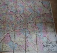
Lake DJ. And Beers SN. D. J. S. N.
MAP OF THE VICINITY OF PHILADELPHIA From Actual Surveys By D.J. Lake and S.N.Beers
Philadelphia: J.E. Gillette & Co. 1861. A very rare large folding map of Philadelphia divided into 36 sections each 22x23 cms and laid on a single linen sheet 132x 138cms 52x54 inches. Hand coloured. Enclosed with marbled paper covers. Only one copy traced. City of Philadelphia Parks and Recreation Historic Archives. No copy traced at auction. PLEASE EMAIL FOR PHOTOS. 1st Edition. Folding Map. Fine. J.E. Gillette & Co. unknown
Référence libraire : TS430
|
|
|
LAMBERT Gustave.-
Carte de l'Expédition Française au Pôle Nord sous le commandement de Mr Gustave Lambert. Régions polaires et boréales. D'après V. A. Malte-Brun.-
Gravé par Erhard Schièble. Paris. 1867. Grande carte 538 x 390mm en couleurs. Partie centrale, cercle de 234 mm de diamètre, indiquant les projets Français, Allemand et Anglais, en encadrement de ce cercle: 1. La Route de l'Expédition Française dans une Projection Etoilée du Dr. Jaeger. 2. Carte des Régions Polaires Australes. 3. Marche supposée du Pôle Magnétique. 4. Courbes des Moyennes d'Insolation au 21 Juin. Ces 3 dernières cartes dans un cercle de 58 mm de diamètre. L'exemplaire a été plié en 4, petite fente réparée sinon bon état. Peu courant.
Référence libraire : ORD-13479
|
|
|
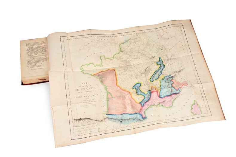
Lamarck (Jean-Baptiste de Monet, chevalier de) et Decandolle (Augustin-Pyrame de) :
Flore française, ou descriptions succintes de toutes les plantes qui croissent naturellement en France, Disposées selon une Nouvelle Méthode d’Analyse, et précédées par un Exposé des Principes élémentaires de la Botanique, Troisième Edition.
Paris, H. Agasse, Imprimerie de Stoupe, an XIII (1805); 4 tomes reliés en 5 volumes in-8 ; veau fauve raciné, dos lisse à décor de style “Bozérian” (reliure de Napoléon), pièces de titre fauve et de tomaison vert empire (reliure de l’époque) ; XVI, 224, (Discours préliminaires et Principes de Botanique), 388 pp., 1 tableau dépliant et 11 planches dépliantes par De Sève ; XII (explication de la carte botanique), 600 pp., très grande carte botanique de la France en couleurs dépliante ; 731 pp. ; (4), 384 pp. ; pp. 385-944, (2) pp.
Référence libraire : 21684
|
|
|
LAMBERT, Anthony
Heritage Railways of the British Isles (texte en anglais)
1999 Ed. Grange Books - 1999 - In-Folio, cartonage illustré en couleurs sous jaquette illustrée en couleurs - 256 p. - Nombreuses reproductions photographiques et cartes en couleurs et N&B - Texte en anglais
Référence libraire : 105149

|
|
|
Lamprecht, H
Die Vervielfältigungstechnik bei d. Herstellung topographischer Karten in d. eichskartenstelle d. Reichsamts für Landesaufnahme.
Berlin, 1926. M. einigen Abb. 58 S. OBr. Umschl. kaum angestaubt. (Mitteil. d. Reichsamts für Landesaufnahme So.-H. 2).
Référence libraire : 187310
|
|
|
LANGLOIS, Hyacinthe
"Nouveau dictionnaire universel, usuel et complet de géographie moderne. Récemment publié par une société de savants, de géographes, d'ingénieurs, professseurs et gens de lettres d'après Maltabrun, Lapie, Balbi, Walkenaer, etc. ; l'Académie des Sciences. Les cartes et plans de la Marine, les dernières découvertes, voyages des navigateurs, et documents inédits jusqu'à ce jour. Extrait et traduit des principales langues de l'Europ rédigés et mis en ordre par Hyacinthe Langlois. Édition compacte de 4000 pages et de 120000 lieux (---), Paris, H. Langlois éditeur-Géographe sans date."
5 vol. in-4° rel. demi-veau bistre, dos à nerfs richement décorés d'une belle frise dorée (Lebrun relieur) - Très beaux exemplaires blanc intérieurement.
Référence libraire : 12471

|
|
|
LANNIER L
L'Europe.
1909 Choix de lectures de géographie Belin 1909 état d'usage 992 pages in 12 reliure demi-basane dos cuir marron à 5 nerfs, plats percaline verte aux armes du lycée Henry IV.l'ouvrage comporte 44 vignettes, 10 cartes en couleurs 53 cartes in texte.
Référence libraire : 7634
|
|
|
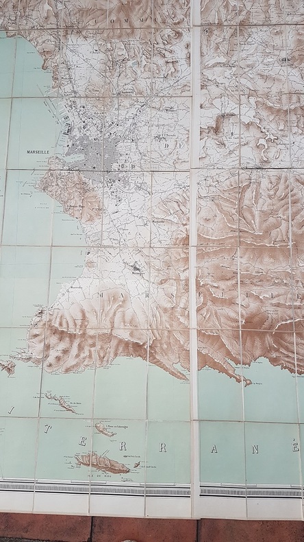
LAN Louis.-
Plan topographique de la Commune de Marseille et des communes environnantes dressé et publié par Ls Lan Chef du Bureau des travaux Publics à la Mairie. Gravé par Erhard. Paris.-
Paris. Imp. Erhard. 1879. Grande carte couleurs en 4 parties de ca 87 x 72 cm formant une fois réunies une carte de 175 x 144 cm, entoilée et repliée en 128 parties de ca 11 x 18 cm sous emboîtage cartonné avec étiquette au dos Commune de Marseille. Cartonnage abîmée carte en excellent état. Rare et remarquable. Photo sur demande.
Référence libraire : ORD-17544
|
|
|
Lancaster,Albert Benoît.
Le Climat de la Belgique.
Di questo annuario, opera del "Mètéorologiste-Inspecteur" dell'Osservatorio reale di Bruxelles, disponiamo dei segg. numeri: 1887,1888,1890,1894-1896,1898,1900,1901. 9 voll. <br/> TITOLO: Le Climat de la Belgique. <br/> AUTORE: Lancaster,Albert Benoît.<br/> EDITORE: F. Hayez, Imprimeur de l'Académie Royale<br/> DATA ED.: 1887-1901,<br/>
|
|
|
Lancaster,Albert Benoît.
Les Tremblements de terre en Belgique.
<br/> TITOLO: Les Tremblements de terre en Belgique. <br/> AUTORE: Lancaster,Albert Benoît.<br/> EDITORE: Hayez, Imprimeur de l'Académie Royale de Belgique<br/> DATA ED.: 1901,<br/> ediz. originale.
|
|
|
LANCIANI Rodolfo
Di un frammento della pianta marmorea severiana rappresentante il clivio della Vittoria ed il Vico Tusco. Estratto dal Bullettino della Commissione Archeologica di Roma (fascicolo IV, 1885)
In 8, pp. 6 con una carta f.t. rip. in cromolit. Br. ed. Saggio relativo alla 'Forma Urbis', una pianta assai dettagliata della citta' di Roma realizzata su grandi lastre di marmo in eta' severiana. La Forma Urbis e' una vera e propria opera cartografica, dove sono indicati, in una scala di notevole dettaglio, e a proiezione verticale, edifici pubblici e privati, templi, terme, vie e interi quartieri.
|
|
|
LANDI Ettore -
Circa un nuovo procedimento per la costruzione delle tavolette-rilievo.
Firenze, 1921, 8vo stralcio con copertina posticcia muta, pp. 311/314. - !! ATTENZIONE !!: Con il termine estratto (o stralcio) intendiamo riferirci ad un fascicolo contenente un articolo di rivista, sia che esso sia stato stampato a parte utilizzando la stessa composizione sia che provenga direttamente da una rivista. Le pagine sono indicate come "da/a", ad esempio: 229/231 significa che il testo è composto da tre pagine. Quando la rivista di provenienza non viene indicata é perchè ci è sconosciuta. - !! ATTENTION !!: : NOT A BOOK : “estratto” or “stralcio” means simply a few pages, original nonetheless, printed in a magazine. Pages are indicated as in "from” “to", for example: 229/231 means the text comprises three pages (229, 230 and 231). If the magazine that contained the pages is not mentioned, it is because it is unknown to us.

|
|
|
LANDI Ettore -
La fotografia del terreno presa dagli aerei e la topografia.
Firenze, 1921, 8vo brossura, articolo di pp. 45/50 con 4 illustrazioni in fascicolo completo de “L'Universo” .

|
|
|
Landwirtschaftliche Akademie Bonn (Hrsg)
Studienordnung für die Studierenden der Geodäsie und Kulturtechnik an der Königlichen landwirtschaftlichen Akademie Bonn-Poppelsdorf. (Neudruck vom Oktober 1904).
Bonn, Carl Georgi Universitäts-Druckerei und Verlag, 1904. 8° (22x14), 24 S., OKart (Brosch), Umschlag etwas verletzt und mit dekorativem Besitzvermerk, 2 Eckknicke, ordentliches Exemplar,
Référence libraire : 43986AB

|
|
|
Lanfranconi, Alberto.
La montagna vuota. le meraviglie, le avventure, i segreti degli abissi della terra nella grotta più estesa e profonda d'Italia.
<br/> STATO: USATO, COME NUOVO.<br/> TITOLO: La montagna vuota. le meraviglie, le avventure, i segreti degli abissi della terra nella grotta più estesa e profonda d'Italia. <br/> AUTORE: Lanfranconi, Alberto.<br/> EDITORE: Bramante Editrice<br/> DATA ED.: 1985,<br/>
|
|
|
LANG, A
Kleine Kartengeschichte Frieslands zwischen Ems und Jade. Entwicklung der Land- u. Seekartographie von ihren Anfängen bis zum Ende des 19. Jahrhunderts.
Norden, (Soltau), 1962. 102 S. m. zahlr. Karten im Text u. auf, teils ausklappbaren Tafeln (Hier büst du to Huus 6). OKart. (Umschlag gebräunt).
Référence libraire : 1320763
|
|
|
Langenmaier, Th
Alte Kenntnis u. Kartographie der zentralafrikanischen Seenregion. Diss.
München, 1916. M. 3 (st. 4) gef. farb. Ktn. VII, 141 S. Hlwd. M. Rücken- u. Deckelsign. u. mehr. Bibl.-St.
Référence libraire : 192317
|
|
|
Langenmaier,Theodor (Dr.).
Lexikon zur alten Geographie des suedoestlichen Aequatorialafrika.
<br/> NOTE: leg. molto allentata, guasti e lacune al dorso.<br/> TITOLO: Lexikon zur alten Geographie des suedoestlichen Aequatorialafrika. <br/> AUTORE: Langenmaier,Theodor (Dr.).<br/> CURATORE: Mit 50 Textskizzen.<br/> EDITORE: L.Friedrichsen & Co.<br/> DATA ED.: 1918,<br/> COLLANA: Coll.Abhandlungen des Hamburgischen Kolonialinstituts, Band XXXIX. Reihe C. Geographie, Geologie, Mineralogie und
|
|
|
Lanzoni,Primo.
Geografia, economica commerciale universale.
<br/> TITOLO: Geografia, economica commerciale universale. <br/> AUTORE: Lanzoni,Primo.<br/> CURATORE: Ottava edizione interamente rifatta da G.Assereto.<br/> EDITORE: Hoepli<br/> DATA ED.: 1926,<br/> COLLANA: Coll.Manuali.<br/>
|
|
|
Lanzoni,Primo.
Geografia, economica commerciale universale.
<br/> STATO: DA COLLEZIONE, MOLTO BUONO.<br/> TITOLO: Geografia, economica commerciale universale. <br/> AUTORE: Lanzoni,Primo.<br/> CURATORE: Decima edizione rifatta e aggiornata da G.Assereto.<br/> EDITORE: Hoepli<br/> DATA ED.: 1935-1939,<br/> COLLANA: Coll.Manuali. Con Appendice 1939 XVII, sull'Africa Orientale Italiana e l'Autarchia.<br/>
|
|
|
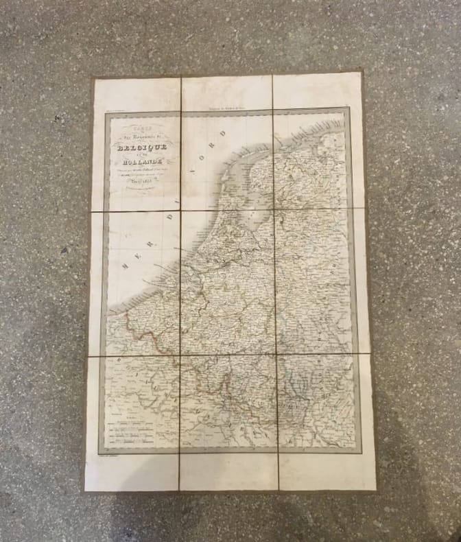
LAPIE (Pierre et Émile) [et] JÄCK (Carl); SOTZMANN (Daniel Friedrich)
Carte des royaumes de Belgique et de Hollande [et] Carte générale des États Prussiens
Paris, chez Eymery, Fruger et Cie, 1833. 66 x 44 cm [et] Berlin, Simon Schropp et Comp., 1802. 67,5 x 103 cm, étui et chemise (chemise et étui défraîchis, rousseurs, déchirures de la toile).
Référence libraire : 18660
|
|
|
Lapierre Dominique
Luna di miele intorno al mondo
illustrazioni

|
|
|
Lapp Ralph E.
Il drago della fortuna [Oceano Pacifico]
1 cartina 15 fotografie in bianco e nero

|
|
|
 Recevoir par e-mail
 Télécharger en PDF
 Flux RSS


