|
ROBERT DE VAUGONDY, Gilles (1688-1766):
Gouvernement general de Languedoc. Par le S. Robert Geographe ordininaire du Roi.
Paris, Durand & Pissot, 1748, 16.5 x 20.5 cm (25 x 37 cm, la feuille), carte coloriée, papier légèrement bruni. 1 feuille.
Referencia librero : 100219aaf

|
|
|
ROBERT DE VAUGONDY, Gilles (1688-1766):
Gouvernement general du Dauphiné. Par le S. Robert Geographe ordininaire du Roi.
Paris, Durand & Pissot, 1748, 17 x 20.5 cm (25 x 37 cm, la feuille), carte coloriée, papier légèrement bruni. 1 feuille.
Referencia librero : 100220aaf

|
|
|
ROBERT DE VAUGONDY, Gilles (1688-1766):
Gouvernement general de Provence. Par le S. Robert Geog. ordin. du Roi.
Paris, Durand & Pissot, 1748, 17 x 20.5 cm (25 x 37 cm, la feuille), carte coloriée, papier légèrement bruni. 1 feuille.
Referencia librero : 100221aaf

|
|
|
ROBERT DE VAUGONDY, Didier (1723-1786):
Indoustan ou Etats du Mogol. Par le Sr. Robert de Vaugondy fils de Mr. Robert Geog. ord. du Roi.
Paris, Durand & Pissot, 1749, 21 x 18 cm (25 x 37 cm, la feuille), carte coloriée, papier légèrement bruni. 1 feuille.
Referencia librero : 100116aaf

|
|
|
ROBERT DE VAUGONDY, Gilles (1688-1766):
Introduction à la connoissance et à l’usage des cartes.
Paris, Durand & Pissot, 1748, 17.5 x 24 cm (25 x 37 cm, la feuille), feuille d’introduction à l’Atlas, papier légèrement bruni. 1 feuille.
Referencia librero : 100103aaf

|
|
|
ROBERT DE VAUGONDY, Gilles (1688-1766):
Italia. - L’Italie et ses Isles circonvoisines, Sicile, Sardaigne, Corse, etc.
Paris, Durand & Pissot, 1748, 16.5 x 18 cm (25 x 37 cm, la feuille), carte coloriée, papier légèrement bruni. 1 feuille.
Referencia librero : 100232aaf

|
|
|
ROBERT DE VAUGONDY, Didier (1723-1786):
La France divisée par Gouvernemens généraux. Par le Sr. Robert de Vaugondy fils de Mr. Robert Geog. ord. du Roi.
Paris, Durand & Pissot, 1749, 18 x 19 cm (25 x 37 cm, la feuille), carte coloriée, papier légèrement bruni. 1 feuille.
Referencia librero : 100204aaf

|
|
|
ROBERT DE VAUGONDY, Gilles (1688-1766):
Lorraine et Alsace. Par le S. Robert Geog. ord. du Roi.
Paris, Durand & Pissot, 1748, 16.5 x 20 cm (25 x 37 cm, la feuille), carte coloriée, papier légèrement bruni. 1 feuille.
Referencia librero : 100210aaf

|
|
|
ROBERT DE VAUGONDY, Gilles (1688-1766):
L’Asie, divisée selon ses differens Etats. Par le Sr. Robert Géographe ordinaire du Roi.
Paris, Durand & Pissot, 1748, 17 x 20.5 cm (25 x 37 cm, la feuille), carte coloriée, papier légèrement bruni. 1 feuille.
Referencia librero : 100109aaf

|
|
|
ROBERT DE VAUGONDY, Didier (1723-1786):
L’Arabie. Par le Sr. Robert de Vaugondy fils de Mr. Robert Geog. ord. du Roi.
Paris, Durand & Pissot, 1749, 17.5 x 18.5 cm (25 x 37 cm, la feuille), carte coloriée, papier légèrement bruni. 1 feuille.
Referencia librero : 100112aaf

|
|
|
ROBERT DE VAUGONDY, Gilles (1688-1766):
L’Empire d’Allemagne. Par le S. Robert Géographe ord. du Roi.
Paris, Durand & Pissot, 1748, 16.5 x 20.5 cm (25 x 37 cm, la feuille), carte coloriée, papier légèrement bruni. 1 feuille.
Referencia librero : 100117aaf

|
|
|
ROBERT DE VAUGONDY, Didier (1723-1786):
Partie Sept.le du Cercle de la Haute Saxe, divisée par ses Principautés. Par le Sr. Robert de Vaugondy fils de Mr. Robert Geog. ord. du Roi.
Paris, Durand & Pissot, 1749, 17 x 21.5 cm (25 x 37 cm, la feuille), carte coloriée, papier légèrement bruni. 1 feuille.
Referencia librero : 100122aaf

|
|
|
ROBERT DE VAUGONDY, Didier (1723-1786):
Partie Meridionale du Cercle de la Haute Saxe, divisée par ses Principautés. Par le Sr. Robert de Vaugondy fils de Mr. Robert Geog. ord. du Roi.
Paris, Durand & Pissot, 1749, 17 x 21 cm (25 x 37 cm, la feuille), carte coloriée, papier légèrement bruni. 1 feuille.
Referencia librero : 100123aaf

|
|
|
ROBERT DE VAUGONDY, Didier (1723-1786):
Partie Septentrionale du Royaume de Portugal. Par le Sr. Robert de Vaugondy fils de Mr. Robert Geog. ord. du Roi.
Paris, Durand & Pissot, 1749, 17 x 20.5 cm (25 x 37 cm, la feuille), carte coloriée, papier légèrement bruni. 1 feuille.
Referencia librero : 100126aaf

|
|
|
ROBERT DE VAUGONDY, Didier (1723-1786):
Partie Meridionale du Royaume de Portugal. Par le Sr. Robert de Vaugondy fils de Mr. Robert Geog. du Roi.
Paris, Durand & Pissot, 1749, 17 x 20.5 cm (25 x 37 cm, la feuille), carte coloriée, papier légèrement bruni. 1 feuille.
Referencia librero : 100128aaf

|
|
|
ROBERT DE VAUGONDY, Didier (1723-1786):
Partie Septent.le des Etats de Castille où se trouvent les Roy.mes des Asturies, de Leon, de la Castille Vielle et la Biscaye. Par le Sr. Robert de Vaugondy fils de Mr. Robert Geog. du Roi.
Paris, Durand & Pissot, 1749, 17 x 19.5 cm (25 x 37 cm, la feuille), carte coloriée, papier légèrement bruni. 1 feuille.
Referencia librero : 100133aaf

|
|
|
ROBERT DE VAUGONDY, Didier (1723-1786):
Partie Meridion.le des Etats de Castille où se trouvent l’Estremadure-de-Leon et la Castille Nouvelle. Par le Sr. Robert de Vaugondy fils de Mr. Robert Geog. du Roi.
Paris, Durand & Pissot, 1749, 17.5 x 24 cm (25 x 37 cm, la feuille), carte coloriée, papier légèrement bruni. 1 feuille.
Referencia librero : 100134aaf

|
|
|
ROBERT DE VAUGONDY, Didier (1723-1786):
Partie Septent.le de la Couronne d’Aragon, où se trouvent le Roy.me d’Aragon et la Principauté de Catalogne. Par le Sr. Robert de Vaugondy fils de Mr. Robert Geog. du Roi.
Paris, Durand & Pissot, 1749, 17.5 x 22 cm (25 x 37 cm, la feuille), carte coloriée, papier légèrement bruni. 1 feuille.
Referencia librero : 100136aaf

|
|
|
ROBERT DE VAUGONDY, Didier (1723-1786):
Partie Méridionale des Etats de Castille où se trouvent l’Andalousie et le Roy.me de Grenade. Par le Sr. Robert de Vaugondy fils de Mr. Robert Geog. du Roi.
Paris, Durand & Pissot, 1749, 17 x 23.5 cm (25 x 37 cm, la feuille), carte coloriée, papier légèrement bruni. 1 feuille.
Referencia librero : 100138aaf

|
|
|
ROBERT DE VAUGONDY, Gilles (1688-1766):
Partie Septentrionale du Royaume de Naples.
Paris, Durand & Pissot, 1748, 16.5 x 20.5 cm, carte coloriée, papier légèrement bruni. 1 feuille, 25 x 37 cm.
Referencia librero : 100230aaf

|
|
|
ROBERT DE VAUGONDY, Gilles (1688-1766):
Partie Méridionale du Royaume de Naples, où se trouvent la Calabre et la Sicile.
Paris, Durand & Pissot, 1748, 17 x 20.5 cm, carte coloriée, papier légèrement bruni. 1 feuille, 25 x 37 cm
Referencia librero : 100231aaf

|
|
|
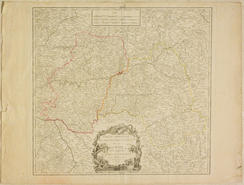
ROBERT DE VAUGONDY (Gilles).
PARTIE ORIENTALE DU GOUVERNEMENT GÉNÉRAL DE LA GUIENNE où se trouvent le Quercy et le Rouergue. [CARTE].
1753 Sans lieu [Paris], sans nom d'éditeur, 1753. Un feuillet double au format in-folio (52 X 69 cm) de papier vergé. Déchirures sans manque dans les marges, pli central, traces de colle au verso, petite mouillure dans l'angle inférieur droit.
Referencia librero : 004834
|
|
|
ROBERT DE VAUGONDY, Didier (1723-1786):
Royaume de Perse. Par le Sr. Robert de Vaugondy fils de Mr. Robert Geog. du Roi.
Paris, Durand & Pissot, 1749, 17.5 x 18.5 cm (25 x 37 cm, la feuille), carte coloriée, papier légèrement bruni. 1 feuille.
Referencia librero : 100113aaf

|
|
|
ROBERT DE VAUGONDY, Gilles (1688-1766):
Royaumes d’Espagne et de Portugal. Par le S. Robert Géographe ord. du Roi.
Paris, Durand & Pissot, 1748, 16 x 20.5 cm (25 x 37 cm, la feuille), carte coloriée, papier légèrement bruni. 1 feuille.
Referencia librero : 100131aaf

|
|
|
ROBERT DE VAUGONDY, Didier (1723-1786):
Royaume de Navarre, divisé en six Mérindades. Par le Sr. Robert de Vaugondy fils de Mr. Robert Geog. du Roi.
Paris, Durand & Pissot, 1749, 24 x 17 cm (37 x 25 cm, la feuille), carte coloriée, papier légèrement bruni. 1 feuille.
Referencia librero : 100135aaf

|
|
|
ROBERT DE VAUGONDY, Gilles (1688-1766):
Turquie asiatique. Par le Sr. Robert Geog. ord. du Roi.
Paris, Durand & Pissot, 1748, 17.5 x 20.5 cm (25 x 37 cm, la feuille), carte coloriée, papier légèrement bruni. 1 feuille.
Referencia librero : 100111aaf

|
|
|
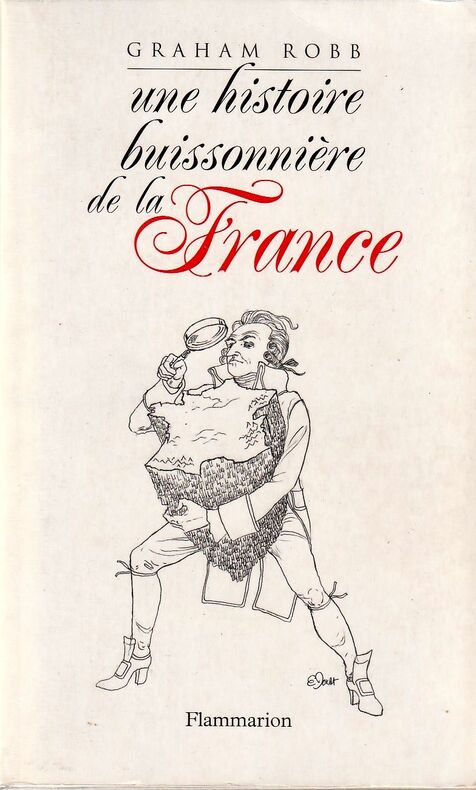
Robb Graham
Une histoire buissonnière de la France.
Flammarion, 2007. Fort volume broché de 575 pages, 16 pages d'illustration hors texte et foliotage. Très agréable exemplaire.
Referencia librero : 18828 ISBN : 208123789
|
|
|
ROBERT DE VAUGONDY, Didier (1723-1786):
Venezia. - Etat de la Seigneurie et Republique de Venise avec l’Evêché de Trente.
Paris, Durand & Pissot, 1749, 17.5 x 39 cm, carte coloriée, papier légèrement bruni. 1 feuille, 25 x 37 cm.
Referencia librero : 100228aaf

|
|
|
Robbe Jacques
Methode pour apprendre facilement la geographie, dediee a monseigneur le duc du Mayne - volume I
In 8°. Pagine (26), 592, (20). Rilegatura in piena pelle coeva, sciupata e con una lieve mancanza al dorso. All'interno macchie e bruniture ed un paio di pagine presentano una lieve bruciatura. Bel frontespizio figurato con una mancanza marginale. Stato di conservazione complessivamente buono. Opera incompleta in quanto si tratta del solo primo volume sui due che la compongono. Tale primo volume è però completo in sé, comprese le 14 meravigliose carte geografiche più volte ripiegate, che sono tutte presenti ed in buono stato di conservazione. La carta d'Italia presenta una lieve lacerazione senza mancanze. Molto raro

|
|
|
Robbiani, Domenico
Genestrerio. Pagliuzze storiche nella cronaca di venti secoli
8°, 23 cm, pp. 257, numerose fotografie a piena pagina, rilegatura editoriale illustrata a colori, titolo al piatto e dorso, esempare ottimo
|
|
|
ROBERT DE VAUGONDY
ETATS DE LA COURONNE D'ARAGON OU SE TROUVENT LES ROYAUMES D'ARAGON ET DE NAVARRE LA PRINCIPAUTE DE CATALOGNE
Paris, Delamarche, fine '700. (Parte incisa: mm. 500 x 540). Carta geografica con lieve coloritura dei confini.

|
|
|
Robert de Vaugondy
Mappe Monde suivant la proiezione des cartes reduites
Incisione su rame, 240 x 395 mm. Acquarellatura probabilmente d'epoca. Nessun difetto. Proveniente da: "Nouvel Atlas Portatif destiné principalement pour l'Instruction de la Jeunesse & precedé d'un Discours sur l'Utede de la Geographie". Bel cartiglio contenente il titolo: "Mappe Monde suivant la proiezione des cartes reduites par S Robert de Vaugondy geog ord du Roi, de S. M. Polon, Duc de Lorr et de Bar, et Associè de L'Academie Royale de Nanci.

|
|
|
ROBERT DE VAUGONDY
PARTIE ORIENTALE DE L'EMPIRE DE RUSSIE EN ASIE, OU SE TROUVENT LES PROVINCES DE JAKUCKSKOY, NERCKZINSKOY, SELINGINSKOY, ILIMSKOY KRASNOJARSKOY, NARIMSKOY, JENISSEISKOY, MANGAJEISKOY ET LES CONFINS DE LA TATARIE CHINOISE. Dressée d'apres les cartes de l'Atlas Russien.
Paris, Delamarche, fine '700. (Parte incisa: mm. 500 x 540). Carta geografica con lieve coloritura dei confini.

|
|
|
ROBERT DE VAUGONDY
Partie septentrionale - meridionale du royaume de Portugal par Robert De Vaugondy
Paris, Delamarche, fine '700. Due carte. (Parte incisa: mm. 500 x 540). Due carte geografiche con lieve coloritura dei confini.

|
|
|
Roberto Almagià
Intorno alla più antica cartografia nautica Catalana
Roberto Almagià Intorno alla più antica cartografia nautica Catalana. , Società geografica Italiana 1945, Intorno alla più antica cartografia nautica Catalana. Estratto dal Bollettino della Soc. Geografica Italiana Serie VII, Vol. X N.1, Gennaio-Giugno 1945. Fascicolo con brossura editoriale scolorita ai bordi, interno ingiallito ma buono. Buono (Good) . <br> <br> <br> 8<br>

|
|
|
Robertson, William
Storia di America del dottore Guglielmo Robertson tradotta dall'originale inglese dall'abate Antonio Pillori fiorentino.
In-8°, mm 190x110, quattro parti in due volumi di pp. 32, 240; 328; 359, (1); VIII, 291, (13), con 4 antiporte incise (raffiguranti Colombo, Las Casas, Cortes e Pizarro) e 4 carte geografiche ripiegate, capilettera e fregi silografici all'interno. Legature coeve in piena pelle con titoli in oro su doppio tassello al dorso. Qualche abrasione, più marcata ai dorsi e limitate tracce di foxing al margine di poche carte, nell'insieme un buono e fresco esemplare. Prima traduzione italiana pubblicata l'anno appresso all'originale inglese per le cure di Antonio Pillori. Non comune quando completa del bell'apparato iconografico perché, come si dichiara all'inizio dell'opera, le carte geografiche non sono state ancora incise e verranno pubblicate successivamente. Le carte disegnate appositamente dal Kitchin, idrografo di sua maestà, raffigurano l'America meridionale; i paesi sopra il Mare Meridionale da Panama a Guayaquil, il Messico o Nuova Spagna, dove si possono rintracciare i movimenti di Hernan Cortes al tempo della conquista e la carta del golfo del Messico con le isole adiacenti. Bibliografia: Sabin 71997

|
|
|
Robin Hosie.
Képes világatlasz.
Naprakész térképek a világ minden tájáról. 230 oldal nagy méretu, gyönyöruen színezett domborzati térkép. Öt hatalmas kihajtható panorámatérkép, amelyeken madártávlatból csodálhatja meg a Föld leglátványosabb tájait: a földközi-tenger térségét, a Himaláját és a Jangce útját. 44 gazdagon illusztrált oldal bolygónk kialakulásáról, állat- és növényvilágáról, a természetes élohelyekrol és arról, hogy <br/> STATO: USATO, COME NUOVO.<br/> TITOLO: Képes világatlasz. <br/> AUTORE: Robin Hosie.<br/> EDITORE: Readers Digest Válogatás<br/> DATA ED.: 1999,<br/> EAN: 9799638475380 9638475382
|
|
|
Robinson, Arthur H
The Look of Maps : An Examination of Cartographic Design
Madison: The University of Wisconsin Press 1952. SCARCE FIRST EDITION. Very Good condition in a Very Good dust jacket. SEE OUR PHOTOS. The jacket has small chips at the spine ends and corners. NOT price clipped $2.75. Protected by a removable Brodart clear-plastic sleeve. NOT a library discard. NO owner's name or bookplate. NO underlining. NO highlighting. NO margin notes. A few tiny brown speckles light foxing on the endpapers and one plate only. 1952. First Edition. A study of maps as art the importance of lettering calligraphy and type styles principles of design use of color hue intensity contrast projection etc. Figures. Tables. Bibliographical references. Bound in the original gilt-stamped green cloth. Complete with dust jacket. First Edition. Hardcover. Very Good condition/Very Good dust jacket. Illus. by NOT a library discard. 8vo. xi 105pp. Great Packaging Fast Shipping. The University of Wisconsin Press Hardcover
Referencia librero : 018855
|
|
|
ROBINSON, Eduard ('Doctor und Professor der Theologie in Neu-York') / E. Smith (Mitreisender)
PALÄSTINA UND DIE SÜDLICH ANGRENZENDEN LÄNDER. - TAGEBUCH EINER REISE IM JAHRE 1838 IN BEZUG AUF DIE BIBLISCHE GEOGRAPHIE unternommen von E. Robinson und E. Smith, nach den Original-Papieren mit historischen Erläuterungen herausgegeben. - DRITTER BAND, Zweite Abtheilung ('Von Hebron nach Wady Mûsa und wieder zurück', 'Von Hebron nach Ramleh und Jerusalem', 'Von Jerusalem nach Nazareth und dem Berge Tabor', 'Vom Berge Tabor längs dem See Tiberias nach Safed', 'Von Safed über Tyrus und Sidon nach Beirût', 'Religiöse Sekten in Syrien und Palaestina', Anhänge); MIT NEUEN KARTEN UND PLÄNEN IN FÜNF BLÄTTERN [='Atlas zu Robinson's Palästina']: 'Der Sinai' / 'Plan von Jerusalem', 'Umgebungen von Jerusalem' / 'Karte von Palaestina', Section I (Phoenice - Galilaea - Coele Syria - Gaulanitis - Ituraea), 'Der nördliche Theil des Libanon', ('Bah Tubariyeh - See Genezareth oder Tiberias'), 'Umgebungen von Beirut' / 'Karte von Palaestina'[, Section II] / 'Karte der Sinai-Halbinsel und des Petraeischen Arabiens', 'Die Gegend zwischen Kairo und Suez', 'Plan von Petra und Laborde', 'Pass von Akabah'. [3. Bd., 2. Teil; neue Karten und Pläne, 5 Blätter; Palaestina]
Halle, Verlag der Buchhandlung des Waisenhauses, 1842. XIV S. (inkl. Titelblatt), bandübergreifend nummerierte Seiten (479)-1.116 (1); 5 (teils groß-)ausfaltbare geographische Tafeln. - Etwas späterer grüner Halbleineneinband mit schwarzen Buchdeckeln, dezenter Rückenvergoldung und goldgeprägtem Rückentitel; 8vo.(ca. 20,5 x 13 x 3,5 cm).
Referencia librero : j2p3c10xbvk
|
|
|
ROCH (Edouard)
Etude stratigraphique et tectonique des environs de Moutiers (Savoie).
Paris & Liège, Ch. BERANGER, 1926. brochure in-8 de 30 pp., 3 fig. dans le texte, 2 pl. dépliantes. Cachets, étiquette de classement.
Referencia librero : 536489
|
|
|
Rochette, Désiré Raoul
Lettres sur quelques cantons de la Suisse ecrites en 1819
8°, pp. VI, 494, paesaggio montano inciso al frontespizio, rilegatura coeva in mezza pelle, titolo su tassello e fregi in oro al dorso, piatti e tagli marmorizzati, esemplare con minime bruniture, per il resto molto buono

|
|
|
Rocque, John
DURHAM MAP
London: Russell and Price 1769. Original Map . No Binding. Fine. 4to. Single page map of the County of DURHAM John Roque. Published in ENGLAND DISLAYED Being a New Complete and Accurate Survey and Description of the Kingdom of England and Principality of Wales. Plate 16 x20cm sheet 160 x 243mm. Fine original map printed on laid paper. Uncoloured. 2ND EDITION pub. 1769. <br/> <br/> Russell and Price unknown
Referencia librero : MAP1026
|
|
|
Rocque, John
GLOUCESTER SHIRE MAP
London: Russell and Price 1769. Original Map . No Binding. Fine. 4to. Single page map of the County of GLOUCESTER SHIRE John Roque. Published in ENGLAND DISLAYED Being a New Complete and Accurate Survey and Description of the Kingdom of England and Principality of Wales. Plate 16 x20cm sheet 160 x 243mm. Fine original map printed on laid paper. Uncoloured. 2ND EDITION pub. 1769. OTHER COUNTIES ARE AVAILABLE FROM THIS ISSUE. <br/> <br/> Russell and Price unknown
Referencia librero : MAP1020
|
|
|
Rocque, John
HAMP-SHIRE MAP
London: Russell and Price 1769. Original Map . No Binding. Fine. 4to. Single page map of the County of HAMPSHIRE John Roque.Published in ENGLAND DISLAYED Being a New Complete and Accurate Survey and Description of the Kingdom of England and Principality of Wales. Plate 16 x20cm sheet 160 x 243mm. Fine original map printed on laid paper. Uncoloured. 2ND EDITION pub. 1769. OTHER COUNTIES ARE AVAILABLE FROM THIS ISSUE. <br/> <br/> Russell and Price unknown
Referencia librero : MAP1006
|
|
|
Rocque, John
HERTFORDSHIRE MAP
London: Russell and Price 1769. Original Map . No Binding. Fine. 4to. Single page map of the County of HERTFORDSHIRE John Roque. Published in ENGLAND DISLAYED Being a New Complete and Accurate Survey and Description of the Kingdom of England and Principality of Wales. Plate 16 x20cm sheet 160 x 243mm. Fine original map printed on laid paper. Uncoloured. 2ND EDITION pub. 1769. OTHER COUNTIES ARE AVAILABLE FROM THIS ISSUE. <br/> <br/> Russell and Price unknown
Referencia librero : Map1009
|
|
|
Rocque, John
HUNTINGDON SHIRE MAP
London: Russell and Price 1769. Original Map . No Binding. Fine. 4to. Single page map of the County of HUNTINGHAMSHIRE John Roque. Published in ENGLAND DISLAYED Being a New Complete and Accurate Survey and Description of the Kingdom of England and Principality of Wales. Plate 16 x20cm sheet 160 x 243mm. Fine original map printed on laid paper. Uncoloured. 2ND EDITION pub. 1769. OTHER COUNTIES ARE AVAILABLE FROM THIS ISSUE <br/> <br/> Russell and Price unknown
Referencia librero : MAP1012
|
|
|
Rocque, John
LANCASHIRE SHIRE MAP
London: Russell and Price 1769. Original Map . No Binding. Fine. 4to. Single page map of the County of LANCASHIRE SHIRE John Roque. Published in ENGLAND DISLAYED Being a New Complete and Accurate Survey and Description of the Kingdom of England and Principality of Wales. Plate 16 x20cm sheet 160 x 243mm. Fine original map printed on laid paper. Uncoloured. 2ND EDITION pub. 1769. OTHER COUNTIES ARE AVAILABLE FROM THIS ISSUE. <br/> <br/> Russell and Price unknown
Referencia librero : MAP1023
|
|
|
Rocque, John
LINCOLN SHIRE MAP
London: Russell and Price 1769. Original Map . No Binding. Fine. 4to. Single page map of the County of NORTHAMPTON SHIRE John Roque. Published in ENGLAND DISLAYED Being a New Complete and Accurate Survey and Description of the Kingdom of England and Principality of Wales. Plate 16 x20cm sheet 160 x 243mm. Fine original map printed on laid paper. Uncoloured. 2ND EDITION pub. 1769. OTHER COUNTIES ARE AVAILABLE FROM THIS ISSUE. A fine dark impression with a trifle staining to the left side paper edge.not near the image. <br/> <br/> Russell and Price unknown
Referencia librero : MAP1014
|
|
|
Rocque, John
MAP OF KENT
London: Russell and Price 1769. Original Map . No Binding. Fine. 4to. Single page map of the County of KENT John Roque.Published in ENGLAND DISLAYED Being a New Complete and Accurate Survey and Description of the Kingdom of England and Principality of Wales. Plate 16 x20cm sheet 160 x 243mm. Fine original map printed on laid paper. Uncoloured. 2ND EDITION pub. 1769. OTHER COUNTIES ARE AVAILABLE FROM THIS ISSUE. <br/> <br/> Russell and Price unknown
Referencia librero : Map1004
|
|
|
Rocque, John
MAP OF SUFFOLK
London: Russell and Price 1769. Original Map . No Binding. Fine. 4to. Single page map of the County of SUFFOLK John Roque.Published in ENGLAND DISLAYED Being a New Complete and Accurate Survey and Description of the Kingdom of England and Principality of Wales. Plate 16 x20cm on sheet 160 x 243mm. Fine original map printed on laid paper. Uncoloured. 2ND EDITION DATED 1769. OTHER COUNTIES ARE AVAILABLE FROM THIS ISSUE. <br/> <br/> Russell and Price unknown
Referencia librero : Map1003
|
|

 Recibir por correo electrónico
 Descargar en documento PDF
 Flujo RSS
 Link permanente


