|
ROBERT DE VAUGONDY, Didier (1723-1786):
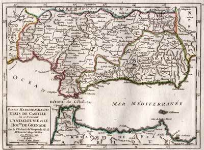
Partie Méridionale des Etats de Castille où se trouvent l’Andalousie et le Roy.me de Grenade. Par le Sr. Robert de Vaugondy fils de Mr. Robert Geog. du Roi.
Paris, Durand & Pissot, 1749, 17 x 23.5 cm (25 x 37 cm, la feuille), carte coloriée, papier légèrement bruni. 1 feuille.
書籍販売業者の参照番号
: 100138aaf
|
|
|
ROBERT DE VAUGONDY, Gilles (1688-1766):
Partie Septentrionale du Royaume de Naples.
Paris, Durand & Pissot, 1748, 16.5 x 20.5 cm, carte coloriée, papier légèrement bruni. 1 feuille, 25 x 37 cm.
書籍販売業者の参照番号
: 100230aaf

|
|
|
ROBERT DE VAUGONDY, Gilles (1688-1766):
Partie Méridionale du Royaume de Naples, où se trouvent la Calabre et la Sicile.
Paris, Durand & Pissot, 1748, 17 x 20.5 cm, carte coloriée, papier légèrement bruni. 1 feuille, 25 x 37 cm
書籍販売業者の参照番号
: 100231aaf

|
|
|
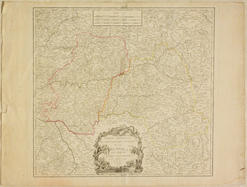
ROBERT DE VAUGONDY (Gilles).
PARTIE ORIENTALE DU GOUVERNEMENT GÉNÉRAL DE LA GUIENNE où se trouvent le Quercy et le Rouergue. [CARTE].
1753 Sans lieu [Paris], sans nom d'éditeur, 1753. Un feuillet double au format in-folio (52 X 69 cm) de papier vergé. Déchirures sans manque dans les marges, pli central, traces de colle au verso, petite mouillure dans l'angle inférieur droit.
書籍販売業者の参照番号
: 004834
|
|
|
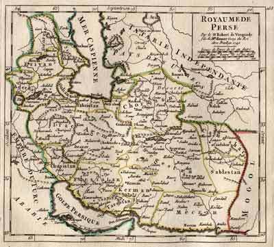
ROBERT DE VAUGONDY, Didier (1723-1786):
Royaume de Perse. Par le Sr. Robert de Vaugondy fils de Mr. Robert Geog. du Roi.
Paris, Durand & Pissot, 1749, 17.5 x 18.5 cm (25 x 37 cm, la feuille), carte coloriée, papier légèrement bruni. 1 feuille.
書籍販売業者の参照番号
: 100113aaf
|
|
|
ROBERT DE VAUGONDY, Gilles (1688-1766):
Royaumes d’Espagne et de Portugal. Par le S. Robert Géographe ord. du Roi.
Paris, Durand & Pissot, 1748, 16 x 20.5 cm (25 x 37 cm, la feuille), carte coloriée, papier légèrement bruni. 1 feuille.
書籍販売業者の参照番号
: 100131aaf

|
|
|
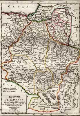
ROBERT DE VAUGONDY, Didier (1723-1786):
Royaume de Navarre, divisé en six Mérindades. Par le Sr. Robert de Vaugondy fils de Mr. Robert Geog. du Roi.
Paris, Durand & Pissot, 1749, 24 x 17 cm (37 x 25 cm, la feuille), carte coloriée, papier légèrement bruni. 1 feuille.
書籍販売業者の参照番号
: 100135aaf
|
|
|
ROBERT GRUSSE
Sillages disparus.
Editions EMON (maritimes et d'outre-mer), 1969, 26 dessins de Pierre Joubert, 52 photographies, 174 pages, in 4, reliure éditeur cartonnée toilée beige, bon état.
書籍販売業者の参照番号
: 6365
|
|
|
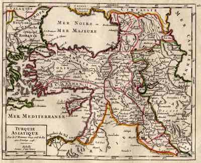
ROBERT DE VAUGONDY, Gilles (1688-1766):
Turquie asiatique. Par le Sr. Robert Geog. ord. du Roi.
Paris, Durand & Pissot, 1748, 17.5 x 20.5 cm (25 x 37 cm, la feuille), carte coloriée, papier légèrement bruni. 1 feuille.
書籍販売業者の参照番号
: 100111aaf
|
|
|
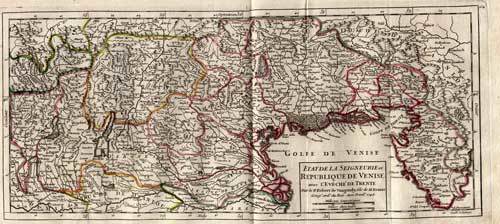
ROBERT DE VAUGONDY, Didier (1723-1786):
Venezia. - Etat de la Seigneurie et Republique de Venise avec l’Evêché de Trente.
Paris, Durand & Pissot, 1749, 17.5 x 39 cm, carte coloriée, papier légèrement bruni. 1 feuille, 25 x 37 cm.
書籍販売業者の参照番号
: 100228aaf
|
|
|
Robbe Jacques
Methode pour apprendre facilement la geographie, dediee a monseigneur le duc du Mayne - volume I
In 8°. Pagine (26), 592, (20). Rilegatura in piena pelle coeva, sciupata e con una lieve mancanza al dorso. All'interno macchie e bruniture ed un paio di pagine presentano una lieve bruciatura. Bel frontespizio figurato con una mancanza marginale. Stato di conservazione complessivamente buono. Opera incompleta in quanto si tratta del solo primo volume sui due che la compongono. Tale primo volume è però completo in sé, comprese le 14 meravigliose carte geografiche più volte ripiegate, che sono tutte presenti ed in buono stato di conservazione. La carta d'Italia presenta una lieve lacerazione senza mancanze. Molto raro

|
|
|
Robbiani, Domenico
Genestrerio. Pagliuzze storiche nella cronaca di venti secoli
8°, 23 cm, pp. 257, numerose fotografie a piena pagina, rilegatura editoriale illustrata a colori, titolo al piatto e dorso, esempare ottimo
|
|
|
Robert / Bob G. Joplin / This Book is SIGNED AND INSCRIBED BY THE AUTHOR / Illustrations By Kurtis L. Kasner Cartography By The
Family Hike : Southern California Self Guided Nature Trails More Than 30 Self Guided Hikes Maps directions Milage Nature Trails Half Day or Whole Day Outings Time with Your Children Low Cost Exploration Natural History Animal Tracks fun
Clean and Unmarked Text: Coyote Creek Press 1985 Paperback : soft cover edition in good to better condition a typical used book with slight wear to edges and spine. Overall good / nice copy of this scarce title. Excellent reading on the subject. A good book to enjoy and keep on hand for yourself. Or would make a GREAT GIFT for the fan / reader in your life. Reading is one of the great pleasures in life. SIGNED & INSCRIBED By Author. White Cover Shows Minor Soil. ~ SCARCE TITLE ~. Illus. by Some b/w Illustrations. Travel / Culture / History / Life. Trails Maps Guidebook. Coyote Creek Press 1985
書籍販売業者の参照番号
: 5025858

|
|
|
ROBERT DE VAUGONDY
ETATS DE LA COURONNE D'ARAGON OU SE TROUVENT LES ROYAUMES D'ARAGON ET DE NAVARRE LA PRINCIPAUTE DE CATALOGNE
Paris, Delamarche, fine '700. (Parte incisa: mm. 500 x 540). Carta geografica con lieve coloritura dei confini.

|
|
|
Robert de Vaugondy
Mappe Monde suivant la proiezione des cartes reduites
Incisione su rame, 240 x 395 mm. Acquarellatura probabilmente d'epoca. Nessun difetto. Proveniente da: "Nouvel Atlas Portatif destiné principalement pour l'Instruction de la Jeunesse & precedé d'un Discours sur l'Utede de la Geographie". Bel cartiglio contenente il titolo: "Mappe Monde suivant la proiezione des cartes reduites par S Robert de Vaugondy geog ord du Roi, de S. M. Polon, Duc de Lorr et de Bar, et Associè de L'Academie Royale de Nanci.

|
|
|
ROBERT DE VAUGONDY
PARTIE ORIENTALE DE L'EMPIRE DE RUSSIE EN ASIE, OU SE TROUVENT LES PROVINCES DE JAKUCKSKOY, NERCKZINSKOY, SELINGINSKOY, ILIMSKOY KRASNOJARSKOY, NARIMSKOY, JENISSEISKOY, MANGAJEISKOY ET LES CONFINS DE LA TATARIE CHINOISE. Dressée d'apres les cartes de l'Atlas Russien.
Paris, Delamarche, fine '700. (Parte incisa: mm. 500 x 540). Carta geografica con lieve coloritura dei confini.

|
|
|
ROBERT DE VAUGONDY
Partie septentrionale - meridionale du royaume de Portugal par Robert De Vaugondy
Paris, Delamarche, fine '700. Due carte. (Parte incisa: mm. 500 x 540). Due carte geografiche con lieve coloritura dei confini.

|
|
|
Roberto Almagià
Intorno alla più antica cartografia nautica Catalana
Roberto Almagià Intorno alla più antica cartografia nautica Catalana. , Società geografica Italiana 1945, Intorno alla più antica cartografia nautica Catalana. Estratto dal Bollettino della Soc. Geografica Italiana Serie VII, Vol. X N.1, Gennaio-Giugno 1945. Fascicolo con brossura editoriale scolorita ai bordi, interno ingiallito ma buono. Buono (Good) . <br> <br> <br> 8<br>

|
|
|
Robertson, William
Storia di America del dottore Guglielmo Robertson tradotta dall'originale inglese dall'abate Antonio Pillori fiorentino.
In-8°, mm 190x110, quattro parti in due volumi di pp. 32, 240; 328; 359, (1); VIII, 291, (13), con 4 antiporte incise (raffiguranti Colombo, Las Casas, Cortes e Pizarro) e 4 carte geografiche ripiegate, capilettera e fregi silografici all'interno. Legature coeve in piena pelle con titoli in oro su doppio tassello al dorso. Qualche abrasione, più marcata ai dorsi e limitate tracce di foxing al margine di poche carte, nell'insieme un buono e fresco esemplare. Prima traduzione italiana pubblicata l'anno appresso all'originale inglese per le cure di Antonio Pillori. Non comune quando completa del bell'apparato iconografico perché, come si dichiara all'inizio dell'opera, le carte geografiche non sono state ancora incise e verranno pubblicate successivamente. Le carte disegnate appositamente dal Kitchin, idrografo di sua maestà, raffigurano l'America meridionale; i paesi sopra il Mare Meridionale da Panama a Guayaquil, il Messico o Nuova Spagna, dove si possono rintracciare i movimenti di Hernan Cortes al tempo della conquista e la carta del golfo del Messico con le isole adiacenti. Bibliografia: Sabin 71997

|
|
|
Robin Hosie.
Képes világatlasz.
Naprakész térképek a világ minden tájáról. 230 oldal nagy méretu, gyönyöruen színezett domborzati térkép. Öt hatalmas kihajtható panorámatérkép, amelyeken madártávlatból csodálhatja meg a Föld leglátványosabb tájait: a földközi-tenger térségét, a Himaláját és a Jangce útját. 44 gazdagon illusztrált oldal bolygónk kialakulásáról, állat- és növényvilágáról, a természetes élohelyekrol és arról, hogy <br/> STATO: USATO, COME NUOVO.<br/> TITOLO: Képes világatlasz. <br/> AUTORE: Robin Hosie.<br/> EDITORE: Readers Digest Válogatás<br/> DATA ED.: 1999,<br/> EAN: 9799638475380 9638475382
|
|
|
Robinson Arthur H
The Look of Maps : An Examination of Cartographic Design
Madison: The University of Wisconsin Press 1952. Very Good condition in a Very Good dust jacket. The jacket has small chips at the spine ends and corners. NOT price clipped $2.75. Protected by a removable Brodart clear-plastic sleeve. NOT a library discard. NO owner's name or bookplate. NO underlining. NO highlighting. NO margin notes. A few tiny brown speckles light foxing on the endpapers and one plate only. 1952. First Edition. A study of maps as art the importance of lettering calligraphy and type styles principles of design use of color hue intensity contrast projection etc. Figures. Tables. Bibliographical references. Bound in the original gilt-stamped green cloth. Complete with dust jacket. First Edition. Hardcover. Very Good condition/Very Good dust jacket. 8vo. xi 105pp. Great Packaging Fast Shipping. The University of Wisconsin Press Hardcover
書籍販売業者の参照番号
: 018855
|
|
|
Robinson Arthur Howard
The Look of Maps : An Examination of Cartographic Design
Madison / London: The University of Wisconsin Press 1985. Appears unread. Fine condition. NOT a library discard. Bright clean square and tight. Sharp corners. Hinges are perfect. NO owner's name or bookplate. NOT a remainder. Pages are creamy white crisp and unmarked. NO underlining. NO highlighting. NO margin notes. A study of maps as art the importance of lettering calligraphy and type styles principles of design use of color hue intensity contrast projection etc. Bound in the original green cloth stamped in black. 1985 printing of the 1952 original. Hardcover. Fine condition/No jacket as issued. 8vo. xii 105pp. Great Packaging Fast Shipping. The University of Wisconsin Press Hardcover
書籍販売業者の参照番号
: 017133 ISBN : 0299009505 9780299009502
|
|
|
Robinson Arthur Howard
The Look of Maps : An Examination of Cartographic Design new in publisher's shrinkwrap
Madison / London: The University of Wisconsin Press 1985. Brand New in perfect condition. Still SEALED in the publisher's original shrinkwrap. Bright clean square and tight. Sharp corners. Hinges are perfect. NO owner's name or bookplate. NOT a remainder. Pages are creamy white crisp and unmarked. NO underlining. NO highlighting. NO margin notes. A study of maps as art the importance of lettering calligraphy and type styles principles of design use of color hue intensity contrast projection etc. Bound in the original green cloth stamped in black. 1985 printing of the 1952 original. Hardcover. New/in publisher's shrinkwrap. 8vo. xii 105pp. Great Packaging Fast Shipping. The University of Wisconsin Press Hardcover
書籍販売業者の参照番号
: 017138 ISBN : 0299009505 9780299009502
|
|
|
ROBINSON, Eduard ('Doctor und Professor der Theologie in Neu-York') / E. Smith (Mitreisender)
PALÄSTINA UND DIE SÜDLICH ANGRENZENDEN LÄNDER. - TAGEBUCH EINER REISE IM JAHRE 1838 IN BEZUG AUF DIE BIBLISCHE GEOGRAPHIE unternommen von E. Robinson und E. Smith, nach den Original-Papieren mit historischen Erläuterungen herausgegeben. - DRITTER BAND, Zweite Abtheilung ('Von Hebron nach Wady Mûsa und wieder zurück', 'Von Hebron nach Ramleh und Jerusalem', 'Von Jerusalem nach Nazareth und dem Berge Tabor', 'Vom Berge Tabor längs dem See Tiberias nach Safed', 'Von Safed über Tyrus und Sidon nach Beirût', 'Religiöse Sekten in Syrien und Palaestina', Anhänge); MIT NEUEN KARTEN UND PLÄNEN IN FÜNF BLÄTTERN [='Atlas zu Robinson's Palästina']: 'Der Sinai' / 'Plan von Jerusalem', 'Umgebungen von Jerusalem' / 'Karte von Palaestina', Section I (Phoenice - Galilaea - Coele Syria - Gaulanitis - Ituraea), 'Der nördliche Theil des Libanon', ('Bah Tubariyeh - See Genezareth oder Tiberias'), 'Umgebungen von Beirut' / 'Karte von Palaestina'[, Section II] / 'Karte der Sinai-Halbinsel und des Petraeischen Arabiens', 'Die Gegend zwischen Kairo und Suez', 'Plan von Petra und Laborde', 'Pass von Akabah'. [3. Bd., 2. Teil; neue Karten und Pläne, 5 Blätter; Palaestina]
Halle, Verlag der Buchhandlung des Waisenhauses, 1842. XIV S. (inkl. Titelblatt), bandübergreifend nummerierte Seiten (479)-1.116 (1); 5 (teils groß-)ausfaltbare geographische Tafeln. - Etwas späterer grüner Halbleineneinband mit schwarzen Buchdeckeln, dezenter Rückenvergoldung und goldgeprägtem Rückentitel; 8vo.(ca. 20,5 x 13 x 3,5 cm).
書籍販売業者の参照番号
: j2p3c10xpkv
|
|
|
ROCH (Edouard)
Etude stratigraphique et tectonique des environs de Moutiers (Savoie). Bulletin des services de la carte géologique de la France et des topographies souterraines, n° 160 - Tome 29, 1925-1926.
Paris & Liège, Ch. BERANGER, 1926. brochure in-8 de 30 pp., 3 fig. dans le texte, 2 pl. dépliantes. Cachets, étiquette de classement.
書籍販売業者の参照番号
: 536489
|
|
|
Rochette, Désiré Raoul
Lettres sur quelques cantons de la Suisse ecrites en 1819
8°, pp. VI, 494, paesaggio montano inciso al frontespizio, rilegatura coeva in mezza pelle, titolo su tassello e fregi in oro al dorso, piatti e tagli marmorizzati, esemplare con minime bruniture, per il resto molto buono

|
|
|
RODI Cesare
COMO: LE MURA. Documenti di storia cittadina.
In-8 oblungo (cm. 25,7 x 35), tela editoriale, sovracoperta, pp. 123,(9), con numerose riproduzioni nel testo di piante, prospetti, disegni, etc. Ben conservato.
|
|
|
Rodolfo Lanciani
Forma urbis Romae. Scala 1: 2000 f. S.
Rodolfo Lanciani Forma urbis Romae. Scala 1: 2000 f. S.. , Quasar 1991, Rappresentazione cartografica di Roma antica, unica nel suo genere che nessuna città al mondo possiede. Manca di sovraccoperta. Copertina rigida con minime tracce d'uso e tempo. Interno in buonissimo stato. Buono (Good) . <br> <br> hardcover <br> 46<br> 8870970132

|
|
|
ROEGIERS, Jan/DEPUYDT, Frans en VAN DER HERTEN, Bart.
EENHEID OP PAPIER. DE NEDERLANDEN IN KAART VAN KEIZER KAREL TOT WILLEM I.
Leuven, Davidsfonds, 1994 originele uitgeversomslag in kleur, 20x16.4 cm., 135 pp., geillustreerd in z/w en in kleur ISBN 9789061528692.
書籍販売業者の参照番号
: 37452
|
|
|
ROEGIERS, Jan/DEPUYDT, Frans en VAN DER HERTEN, Bart.
EENHEID OP PAPIER. DE NEDERLANDEN IN KAART VAN KEIZER KAREL TOT WILLEM I.
Leuven, onze liever vrouw der predikheren, 1994 originele uitgeversomslag in kleur, 29x16.4 cm., 125 pp., geillustreerd in z/w ISBN 9789061528692.
書籍販売業者の参照番号
: 53495
|
|
|
ROEGIERS, Jan/DEPUYDT, Frans en VAN DER HERTEN, Bart.
EENHEID OP PAPIER. DE NEDERLANDEN IN KAART VAN KEIZER KAREL TOT WILLEM I.
originele uitgeversomslag in kleur, 20x16.4 cm., 135 pp., geillustreerd in z/w en in kleur ISBN 9789061528692. Uitgegeven ter gelegenheid van de gelijknamige tentoonstelling in Leuven, georganiseerd in samenwerking door Stad Leuven, K. U. Leuven en het Davidsfonds in de gerestaureerde kerk van Onze-Lieve-Vrouw-ter Predikheren 5 oktober - 4 december 1994.

|
|
|
ROEGIERS, Jan/DEPUYDT, Frans en VAN DER HERTEN, Bart.
EENHEID OP PAPIER. DE NEDERLANDEN IN KAART VAN KEIZER KAREL TOT WILLEM I.
originele uitgeversomslag in kleur, 29x16.4 cm., 125 pp., geillustreerd in z/w ISBN 9789061528692. tentoonstellings catalogus Uitgegeven ter gelegenheid van de gelijknamige tentoonstelling in Leuven, georganiseerd in samenwerking door Stad Leuven, K. U. Leuven en het Davidsfonds in de gerestaureerde kerk van Onze-Lieve-Vrouw-ter Predikheren 5 oktober - 4 december 1994.

|
|
|
ROGER DEVIGNE
Le légendaire des provinces françaises à travers notre folklore (Angoumois, Normandie, Gascogne, Provence, Poitou, Lorraine, Bretagne, Saintonge, Flandres, Ardennes, Auvergne, Champagne).
Horizons de France, 1950, 251 pages, in 8 broché, bon état.
書籍販売業者の参照番号
: 12282
|
|
|
Roger A. Blondeau
Mercator van Rupelmonde
, Uitgeverij Terra - Lannoo 1993, 1993 Hardcover, 144 pagina's, Nederlands, 250 x 160 mm, omslag enkele krasjes maar boek zelf in prima staat, met enkele illustraties in z/w. ISBN 9789020923018.
書籍販売業者の参照番号
: 56322
|
|
|
ROGER VERCEL
Remorques.
Le Livre de Poche, 1964, 247 pages, in 12 format poche, bon état.
書籍販売業者の参照番号
: 7617
|
|
|
ROGER (Elizabeth M.) Compiler.
The Large Scale County Maps of the British Isles 1596-1850: A Union List.
Second edition, revised, xx, 56pp., orig. printed wrappers.
|
|
|
Roger A. Blondeau
Mercator van Rupelmonde
Hardcover, 144 pagina's, Nederlands, 250 x 160 mm, omslag enkele krasjes maar boek zelf in prima staat, met enkele illustraties in z/w. ISBN 9789020923018. Gerard Mercator is voor de cartografie wat Andreas Vesalius voor de geneeskunde en Simon Stevin voor de wetenschappen betekenen. Door zijn studies en vernieuwingen werd deze 16de-eeuwse wetenschapper als de grootste cartograaf van zijn tijd beschouwd. Roger-A. Blondeau tekent op indringende wijze het portret van deze markante figuur. Het is een hommage aan Mercator naar aanleiding van de vierhonderdste verjaardag van zijn overlijden.

|
|
|
ROGER BAYNTON - WIULLIAMS
INVESTING IN MAPS
IN 4°, pp.160, COPERTINA EDITORIALE IN PIENA TELA RIGIDA CARTONATA NERA CON TITOLO AL DORSO + SOVRACOPERTINA ILLUSTRATA A COLORI CON TITOLO. VOLUME RICCAMENTE ILLUSTRATO in b/n/col. ANCHE a pp. CON CARTE GEOGRAFICHE E PIANTE DI VARI E PARTI DEL MONDO, PLANISFERI E GLOBI CELESTI. OTTIMA CONSERVAZIONE. ID 4852

|
|
|
Rohricht, Reinhold
Chronologisches Verzeichnis: Der von 333 bis 1878 Verfassten Literatur Uber die Heilige Land mit dem Verusch Einer Kartographie [SERIES]: Biblioteca Geographica Palaestinae
17x14 cm. XVI+816 pages. Gilt hardcover. Cover slightly chafed, slightly stained. Spine slightly chafed. Else in good condition.
|
|
|
ROIG Gérard
Cours de calculs topométriques, à l'usage des candidats au C.A.P., d'opérateur-géomètre et des candidats à l'examen préliminaire de géomètre-expert D.P.L.G. Collection des cours, l'Ecole chez soi.
Paris, Editions Eyrolles, 1967. 16 x 25, 166 pp., nombreuses figures, broché, très bon état (1 cachet d'ex-propriétaire).
書籍販売業者の参照番号
: 90366
|
|
|
ROLF FRIB
DORTMUNDER KIRCHEN UND IBRE KUNFTFCHAKE.
Drud und Verlag Kruger, Gmbh Dortmund, 1932, in8, reliure editeur catonnée, dos et mors toilé gris, bon état, 109 pages + ex libris
書籍販売業者の参照番号
: 5136
|
|
|
ROMANOVSKY,CLAUDE BOEUF,JACQUES BOUCART ,J YVES COUSTEAU
La mer.
Larousse 1953 très bon état 503pages in 4.L'ouvrage comporte 870 illustrations in texte et 16 hors texte en couleurs.Reliure éditeur percaline verte ouvragée .
書籍販売業者の参照番号
: 2687
|
|
|
Rombai L
P Giovanni Inghirami astronomo geodeta e cartografo
macchia piatto anteriore di copertina

|
|
|
Rombai L a cura
Imago et descriptio Tusciae la Toscana nella geocartografia dal XV al XIX secolo
leggeri quasi impercettibili segni del tempo

|
|
|
ROMBAI LEONARDO e CIAMPI GABRIELE ( A CURA DI )
CARTOGRAFIA STORICA DEI PRESIDIOS IN MAREMMA ( SECOLI XVI - XVIII )
IN 4° ( cm.21,5 X 31 ), pp.297, INDICE. COPERTINA EDITORIALE ILLUSTRATA CON TITOLO.<BR>IL VOLUME, COMPRENDE 125 ILLUSTRAZIONI DI CARTE DELLA MAREMMA CON RELATIVE SCHEDE BIBLIOGRAFICHE. CATALOGO DELLA MOSTRA DEL CONSORZIO UNIVERSITARIO<BR>INTERPROVINCIALE CON SIENA, AREZZO E GROSSETO, CHE RACCOGLIE UNA ICONOGRAFIA INEDITA E SCIENTIFICAMENTE CATALOGATA. OLTRE A ROMBAI E CIAMPI HA COLLABORATO MAURIZIO DE VITA. INTRODUZIONE DI GIORGIO SPINI. MINIMA SPELLATURA AL DORSO NELLA PARTE DI TESTA, ALTRIMENTI OTTIMA CONSERVAZIONE GENERAE. RARO. ID, 6873

|
|
|
Rombai,Leonardo.
Geografia storica dell'Europa occidentale.
<br/> STATO: USATO, MOLTO BUONO.<br/> TITOLO: Geografia storica dell'Europa occidentale. <br/> AUTORE: Rombai,Leonardo.<br/> CURATORE: A cura di Mario Pinzni e Simone Squarzanti.<br/> EDITORE: Centro Editoriale Toscano<br/> DATA ED.: 1997,<br/> COLLANA: Coll.Didattica.<br/> EAN: 9788879571074

|
|
|
Rombai,Leonardo.
P. Giovanni Inghirami. Astronomo, geodeta e cartografo. "l illustrazione geografica della Toscana".
<br/> STATO: USATO, MOLTO BUONO.<br/> TITOLO: P. Giovanni Inghirami. Astronomo, geodeta e cartografo. "l illustrazione geografica della Toscana". <br/> AUTORE: Rombai,Leonardo.<br/> EDITORE: Osservatorio Ximeniano<br/> DATA ED.: 1989,<br/>
|
|
|
Rombai,Leonardo.
Toscana e Italia tra Risorgimento e Unità : le innovazioni cartografiche del XIX secolo nelle conservatorie dell’Istituto Geografico Militare.
<br/> STATO: NUOVO.<br/> TITOLO: Toscana e Italia tra Risorgimento e Unità : le innovazioni cartografiche del XIX secolo nelle conservatorie dell’Istituto Geografico Militare. <br/> AUTORE: Rombai,Leonardo.<br/> EDITORE: Istituto Geografico Militare<br/> DATA ED.: 2013,<br/>
|
|
|
Romeo A.
Compendio Di Topografia
Mm 160x220 Brossura editoriale di pp. 97+indice+tavole con figure fuori testo, con 75 illustrazioni in bianco e nero nel testo. piccola lacuna al piatto e sguardia posteriore. Firma d'appartenenza al piatto anteriore. SPEDIZIONE IN 24 ORE DALLA CONFERMA DELL'ORDINE.
|
|
|
ROMERO FEDERICO (TESTO DI)
COME SI LEGGE LA CARTA TOPOGRAFICA
In-8 (Cm 24 x 17), pp. 35, br. ed. 17 carte e ill. nel test o (Mayer Giuseppe) Collana "Manualetti di tecnica Militare Volgarizzata editi dalla rivista Nazione Militare". Piccolo tagliandini di catalogazione alla br. ant. Millimetriche e marginali macchioline al margine esterno e sup. della br. Millimetrico strappetto alla br. post. Ordinari segni del tempo. BUONO

|
|
 検索結果のメールを受信する
 PDFファイルの検索結果をダウンロード
 RSSフィード


