|
GUARNIERI, GINO.
La Scuola Livornese di Cartografia Nautica nel suo inquadramento tecnico e storico (1592 - 1688).
Tipografia O. Debatte e F., Livorno, 1967. Sotto gli auspici della Deputazione di Storia Patria per la Toscana. Con dodici fotoriproduzioni. In 8vo, pp. 12 + 11 carte in b/n f. t. in fine, bross. edit. in carta lucida con ill. Conservato il foglio di estratto editoriale. Minima patina del tempo e una leggera piega delle pagine, buono.
|
|
|
GUARNIERI, GIUSEPPE GINO.
Il Mediterraneo nella storia della cartografia Nautica Medioevale. Con un catalogo delle carte portolaniche.
Casa Editrice S. T. E. T., Livorno, 1933 – XII. In 8vo, pp. 132, ill. fot. in b/n n.t., leg.in t. tela verde forse mancante della sovrac., piccola plancetta in carta. Uniforme ingillimento delle pagine con minime imperfezioni e qualche segnatura ma buono.
|
|
|
Guerci, Gabriella - Pelissetti, Laura - Scazzosi, Lionella ( a cura di )
Oltre il Giardino. Le Architetture Vegetali e il Paesaggio
Mm 170x240 Collana " Giardini e Paesaggio ". Brossura originale, viii-413 pp. con numerose illustrazioni in nero nel testo e 16 tavole a colori fuori testo. Pubblicazione che raccoglie gli atti delle giornate di studio tenute a Cinisello Balsamo il 26, 27 e 28 settembre del 2002. Libro in ottime condizioni ovvero mai letto, spedizione in 24 ore dalla conferma dell'ordine.
|
|
|
Guerra,Roberto.
Fiume Livenza e suoi principali affluenti Meduna e Monticano nonché il fiume Noncello affluente del Meduna ( 1869 ) .
<br/> STATO: NUOVO.<br/> TITOLO: Fiume Livenza e suoi principali affluenti Meduna e Monticano nonché il fiume Noncello affluente del Meduna (1869). <br/> AUTORE: Guerra,Roberto.<br/> CURATORE: Edizione critica e strumenti di ricerca a cura di Roberto Guerra. Presentazione di Giuseppe Marson. Prefaz.di Massimo Mattozzi.<br/> EDITORE: Tipolitografia Rubino<br/> DATA ED.: 2001,<br/> COLLANA: Con la r
|
|
|
Guerra,Roberto.
Liquentia. Un fiume nella X regio augustea Venetia et Histria.
<br/> STATO: NUOVO.<br/> TITOLO: Liquentia. Un fiume nella X regio augustea Venetia et Histria. <br/> AUTORE: Guerra,Roberto.<br/> EDITORE: Tipolitografia Rubino<br/> DATA ED.: 2005,<br/> EAN: 9788890128172
|
|
|
GUIBERT-FOURRÉ, Florence
La Géographie de nos grands-mères. Archives & Culture. 2008.
1 volume à l'italienne plein cartonnage illustré, 71 p. + illustrations. Très bel état d'occasion.
书商的参考编号 : 23361

|
|
|
Guilbert Gabriel.
LA PREVISION SCIENTIFIQUE DU TEMPS. Traité Pratique.
(Codice SC/0610) In 8º 438 pp. Première édition illustrée avec 21 figures et 7 planches hors texte. Broché, dos dérelié, plats passés (manques, taches), intérieur en bon état. ~~~ SPEDIZIONE IN ITALIA SEMPRE TRACCIATA

|
|
|
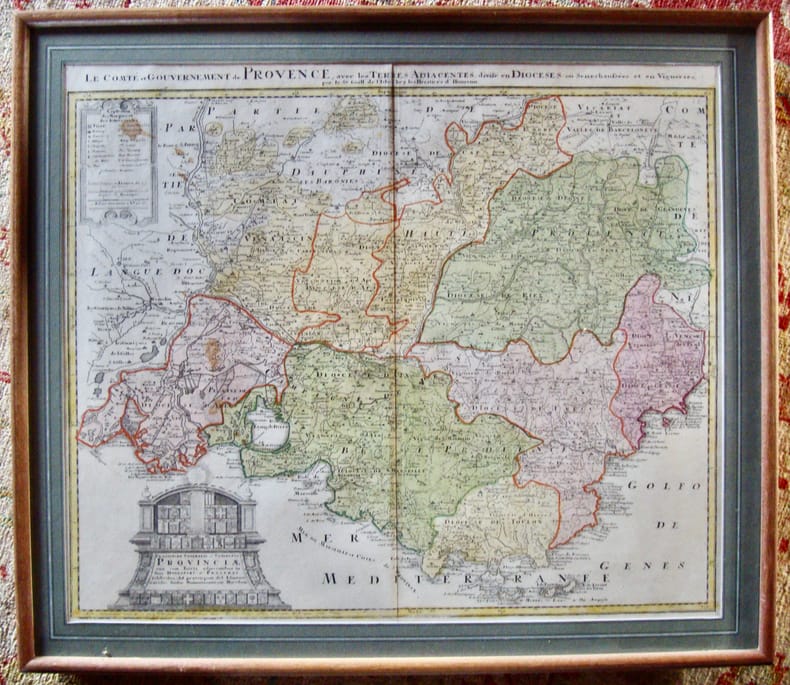
Guillaume de l’Isle,
Le Comté et Gouvernement de Provence, avec les terres adjacentes, divisé en diocèses ...
Chez les héritiers d’Homann très bon Hormann XVIIè siècle
书商的参考编号 : 6010
|
|
|
GUILLAUME DELISLE, (1675-1726).
[MAP] Carte de la grece ou turquie d'Europe.
Very Good French Original decorated map. Hand-coloured. Oblong elephant folio. (54 x 76 cm). In French. Shows Greece, Archipelago, Isle de Candie, Asia Minor (Western side), and East Mediterranean. Delisle od de l'Isle was a French cartographer known for his popular and accurate maps of Europe and the newly explored Americas. At 27, Delisle was admitted into the French Académie Royale des Sciences, an institution financed by the French state. After that date, he signed his maps with the title of "Géographe de l'Académie". Five years later, he moved to the Quai de l'Horloge in Paris, a true publishing hub where his business prospered. Delisle's progress culminated in 1718 when he received the title of Premier Géographe du Roi. He was appointed to teach geography to the Dauphin, King Louis XIV's son, a task for which he received a salary. Again, his father's reputation as a man of science probably helped the younger Delisle. Historian Mary Sponberg Pedley says, 'once authority was established, a geographer's name might retain enough value to support two or three generations of mapmakers'. Delisle's case, it could be said that his accomplishments surpassed his father's. Up to that point, he had drawn maps not only of European countries, such as Italy, Spain, Germany, Great Britain, Poland, and regions such as the Duchy of Burgundy, but he had also contributed to the empire's claims to recently explored continents of Africa and the Americas. Like many cartographers of his day, Delisle did not travel with the explorers. He drew maps mostly in his office, relying on a variety of data. The quality of his maps depended on a solid network to provide him first-hand information. Given his family's and his own reputation, Delisle had access to fairly recent accounts of travellers who were returning from the New World, which gave him an advantage over his competitors. Being a member of the Académie, he also kept current with recent discoveries, especially in astronomy and measurement. When he could not confirm the accuracy of a source, he would indicate it clearly on his maps. For instance, his Carte de la Louisiane shows a river that the baron of Lahontan claimed he discovered. As no one else could validate it, Delisle noted a warning to the viewer that it might not exist. (Source: Wikipedia). Tooley, p.43.
|
|
|
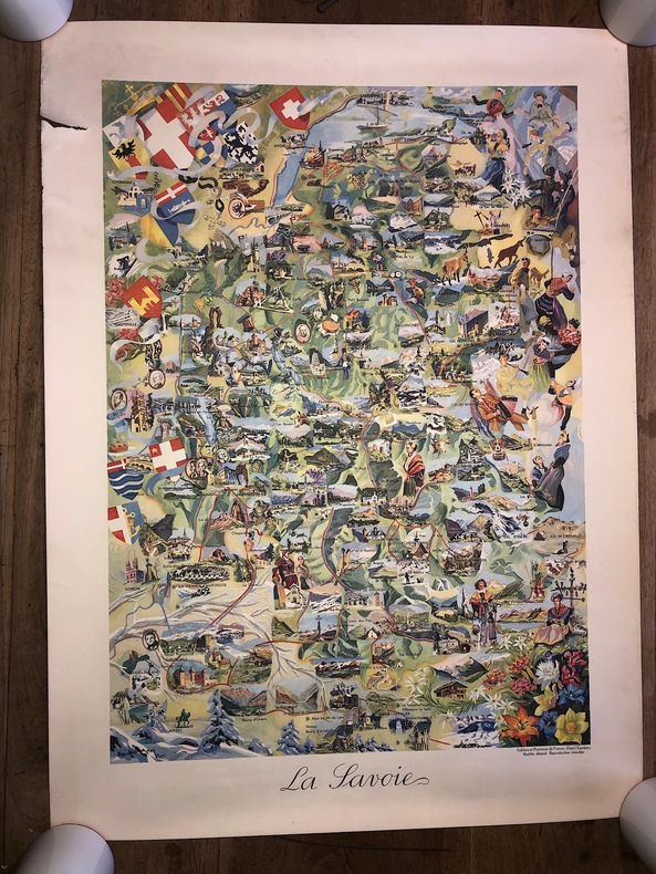
GUILLAUME E. ( illustrateur ) / Editions Efpé ( Editeur Chambéry )
CARTE " LA SAVOIE " en couleurs / Editions Efpé / JANSOL à Chambéry. ( env. 1955 ) . Dimensions : 55 x 75 cm. à toutes marges. Editions FOLKLORE ET PROVINCES DE FRANCE. illustrateur E. Guillaume.Tirage à 300 exemplaires sur vélin des papeteries de Rives. Nota: Les exemplaires de cette carte sont donc très rares. JOLI TIRAGE, très décoratif. TRES BELLE IMPRESSION. à noter une petite pliure en marge sans atteinte à l'illustration.
书商的参考编号 : 2626
|
|
|
GUILLAUME E. ( illustrateur ) / Editions Efpé ( Editeur Chambéry )
CARTE " LA SAVOIE " en couleurs / Editions Efpé / JANSOL à Chambéry. ( env. 1955 ) .
Dimensions : 55 x 75 cm. à toutes marges. Editions FOLKLORE ET PROVINCES DE FRANCE. illustrateur E. Guillaume.Tirage à 300 exemplaires sur vélin des papeteries de Rives. Nota: Les exemplaires de cette carte sont donc très rares. JOLI TIRAGE, très décoratif. TRES BELLE IMPRESSION. à noter une petite pliure en marge sans atteinte à l'illustration.
书商的参考编号 : 2757
|
|
|
GUILLEMIN-TARAYRE, Edmond
Mission scientifique au Mexique et dans l’Amérique Centrale, géologie, description des anciennes possessions mexicaines du Nord.
Paris, Imprimerie Nationale, 1871, in-folio de 216pp., 19 planches repliées, non relié, sous étui, couverture renforcée, petite mouillure angulaire.
书商的参考编号 : PHO-1728

|
|
|
Guiso Maria Antonietta - Muratore Nicoletta
Ad usum navigatium. Carte nautiche Manoscritte di Gerard van Keulen. 1709-1713.
Bross., cm 28,5x22,5, pp 213,85 tavv. a col..

|
|
|
GUISO Maria Antonietta-MURATORE Nicoletta (a cura di).
Ad usum navigantium Carte nautiche manoscritte di Gerard Van Keulen, 1709-1713
con 85 carte a colori a tutta pagina. Indici.
|
|
|
Gunther John
Africa
131 fotografie

|
|
|
Guppy Nicholas
Wai-Way. Attraverso le foreste dell'Amazzonia del Nord [GUIANA BRITANNICA E BRASILE]
illustrazioni

|
|
|
GUSSO Adriana
MESTRE. Le radici identità di una città.
In-4 (cm. 30.90), cartonato editoriale, sovracoperta editoriale illustrata, pp. (160, senza numerazione), con illustrazioni in bianco e nero e a colori nel testo. Piccola abrasione e taglietto al dorso della sovracoperta; peraltro volume in buono stato di conservazione (good copy).
|
|
|
Gutersohn,Enrico. Burki,Carlo. Winkler,Ernesto.
La Terra. Paesi popoli civiltà. Vol. III: Asia, Oceano Indiano, Africa, Oceano Pacifico, Oceania e Australia, Le regioni polari, La Terra nel suo insieme.
un vol. di 3 <br/> TITOLO: La Terra. Paesi popoli civiltà. Vol.III: Asia, Oceano Indiano, Africa, Oceano Pacifico, Oceania e Australia, Le regioni polari, La Terra nel suo insieme. <br/> AUTORE: Gutersohn,Enrico. Burki,Carlo. Winkler,Ernesto.<br/> CURATORE: Traduz. dal tedesco di Eduardo Bermudez de Madariaga.<br/> EDITORE: Editrice Primato<br/> DATA ED.: 1960,<br/>
|
|
|
GUTHRIE William
Nouvelle GÉOGRAPHIE UNIVERSELLE descriptive, historique, industrielle et commerciale des Quatre Parties du Monde + Nouvel ATLAS universel de Géographie ANCIENNE et MODERNE pour la 4ème éd. franç., revu, corrigé avec les nouvelles divisions, d'après les derniers traités de Paix; augm. de cinq grandes magnifiques CARTES politiques et itinéraires de l'EUROPE, et de celle de l'expédition d'Alexandre, par d'ANVILLE, 1807. Tr. par Fr. NOEL. Les parties ASTRON. et COSMOGR. entièrement revues et corrigées par J. LALANDE.
6 parti in 9 voll. in-8° (cm. 21,2x13,5). I) pp. CXLV, (1), 429, (1). II) Pp. (4), 466. III) Pp. (4), 449, (1) + 2 grandi tabelle ripiegate. IV) Pp. (4), 510. V) Pp. (4), 574. VI) Pp. (4), 598 + ATLAS in 4° (cm. 37,5x25,5), pp. (5), (1b) + 50 CARTE coi confini colorati a mano, alcune delle quali grandissime, ripiegate. I voll. di testo in br. orig., tasselli orig. ai ds. Orecchie strappi e mancanze alle leggere copp. (alcuni piatti mancanti) e a qualche tass., ben cuciti e freschi in barbe gli interni. L'Atlante con legatura in tela coeva, tit.(impreciso e riassuntivo) in oro, buon rinforzo recente in tela muta al dorso fioriture. perlopiù solo ai bordi delle bellissime tavole con confini a COLORI; Scozia e Inghilterra hanno un brutto restauro. Celeberrimo ed INTROVABILE, l'ATLANTE di 50 carte, datato 1807. Segnaliamo 2 grandi carte doppie dell'ITALIA, una carta delle scoperte in AFRICA, e una carta doppia grandissima delle scoperte di VANCOUVER in America Sett. In fine, in 11 carte, alc. grandissime, Atlante antico. Rarissima, completa dell'Atlante. Il testo dedica, per esempio, all'ITALIA 130 pp., al Piemonte 6 pp., a San Marino 1 p. Sconfinata miniera di dati, completamente diversa, salvo nell'impianto metodologico, dall'orig. inglese; ovviamente aggiornata ai coevi trionfi NAPOLEONICI in Europa.
|
|
|
Guthrie, William
A NEW Geographical Historical and Commercial Grammar; and present State of the several Kingdoms of the World . illustrated with a correct set of Maps
London: Charles Dilly in the Poultry et al 1788. eleventh edition . Hardback. Vg. 8vo. x 2 928pp. 20 map plates : 2 engeaved illustrations charts maps ; Damp staining to the plates and map in some but compete and tight copy in the original binding. A New System of Modern Geography: or A geographical historical and commercial grammar; and present state of the several kingdoms of the world. : Containing I. the figures motions and distances of the planets according to the Newtonian system and the latest observations. II. A general view of the Earth considered as a planet; with several useful geographical definitions and problems. III. The grand divisions of the globe into land and water continents and islands. IV. The situation and extent of empires kingdoms states provinces and colonies. V. Their climates air soil vegetable productions metals minerals natural curiosities seas rivers bays capes promontories and lakes. VI. The birds and beasts peculiar to each country . XII. The longitude latitude bearings and distances of principal places from London. To which are added I. A geographical index with the names and places alphabetically arranged. II. A table of the coins of all nations and their value in English money. III. A chronological table of remarkable events from the Creation to the present time. Original full calf with red morocco label to the spine. <br/> <br/> Charles Dilly in the Poultry et al hardcover
书商的参考编号 : GT789
|
|
|
GUZZI, FOCOSI
Gran carta d'Italia
Grande carta geografica telata cm 200 x 250 totali, suddivisa in 28 parti (ciascuna cm 51,5 x 37,5). Incisa all'acquaforte. Grande cartiglio allegorico, profilo altimetrico delle Alpi in testa, pianta della citta' di Roma. I 28 fogli sono a loro volta suddivisi in 4 parti ripiegabili e contenuti in apposita cartella. Grande carta murale
|
|
|
GW Bacon G W
MAP OF ENGLAND AND WALES
Oxford: Chart Publishing Company 1900. Slip Case. Fine. Folding map. 2 Folding Charts and an index booklet encased in a blue slipcase. All contents fine Slipcase a trifle toned.Priced at 47/6. Two linen backed LARGE 18 section colour maps. 75x100 and 75x100cms PLEASE EMAIL FOR PHOTOGRAPHS <br/> <br/> Chart Publishing Company unknown
书商的参考编号 : GT244
|
|
|
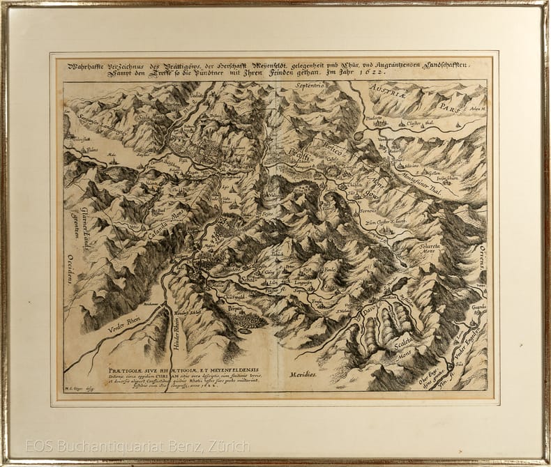
Gyger, H.C.Gyger
Wahrhaffte Verzeichnüs des Prättigöws, der Herrschafft Meyenfeldt, gelegenheit umb Chur, und Angräntzenden Landschafften Sampt den Treffe so die Pündtner mit Ihren Feinden gethan, Im Jahr 1622.
(1635). Kuperstich von Matthäus Merian. Blattgrösse: 28,5 x 37 cm. + Wichtig: Für unsere Kunden in der EU erfolgt der Versand alle 14 Tage verzollt ab Deutschland / Postbank-Konto in Deutschland vorhanden +, 993DG Bildgrösse: 40 x 49 cm.
书商的参考编号 : 993DG

|
|
|
Gyger, H.C.Gyger.-
Wahrhaffte Verzeichnüs des Prättigöws, der Herrschafft Meyenfeldt, gelegenheit umb Chur, und Angräntzenden Landschafften Sampt den Treffe so die Pündtner mit Ihren Feinden gethan, Im Jahr 1622.
(1635) Kuperstich von Matthäus Merian. Blattgrösse: 28,5 x 37 cm. Bildgrösse: 40 x 49 cm.
书商的参考编号 : 993DG
|
|
|
Gyger, Hans Conrad
Karte des Kantons Zürich aus dem Jahr 1667 in 56 Blättern. Faksimiledruck 1967 nach dem Original im Staatsarchiv des Kantons Zürich mit illustriertem Kommentar von Eduard Imhof.
Dietikon-Zürich, Bibliophile Drucke von Josef Stocker, 1967. 4°. 56 Blätter mit Teilkarten (49 zu ca. 30 x 30 cm. und 7 zu ca. 30 x 8 cm.) und 1 Übersichtsraster. Begleitheft: 25 (3) S. Mit zahlr. Abbildungen. In Holzkiste. + Wichtig: Für unsere Kunden in der EU erfolgt der Versand alle 14 Tage verzollt ab Deutschland / Postbank-Konto in Deutschland vorhanden +, A
书商的参考编号 : 25514AB

|
|
|
Gyger, Hans Conrad
Neüe beschreibung der Landschafft Zürich. Hans Conrad Gygers Landkarte des Zürcherischen Staatsgebietes in Kupfer gestochen von Johann Meyer 1685, kommentiert von Georges Grosjean.
Dietikon-Zürich, Verlag Bibliophile Drucke von Josef Stocker, 1980. Folio. (6) 11 (2) S. Mit 3 faks. gest. Karten lose in hint. Deckeltasche (leicht berieben und bestossen). + Wichtig: Für unsere Kunden in der EU erfolgt der Versand alle 14 Tage verzollt ab Deutschland / Postbank-Konto in Deutschland vorhanden + Lieferung 1 (von 2).
书商的参考编号 : 2305DB
|
|
|
Gyger, Hans Conrad
Wahrhaffte Verzeichnus des Prättigöws der Herschafft Meyenfeldt gelegenheit umb Chur und Angräntzenden Landschafften Sampt den Treffé so die Pündtner mit Ihren Feinden gethan Im Jahr 1622.
Ditetikon-Zürich, Bibliophile Drucke von Josef Stocker, 1973. Quer-Folio. 1 Karte lose in Orig.-Umschlag. + Wichtig: Für unsere Kunden in der EU erfolgt der Versand alle 14 Tage verzollt ab Deutschland / Postbank-Konto in Deutschland vorhanden +, A|B [2 Warenabbildungen] Faksimiledruck.
书商的参考编号 : 2295DB

|
|
|
Gyger, Hans Conrad:
Karte des Kantons Zürich aus dem Jahr 1667 in 56 Blättern. Faksimiledruck 1967 nach dem Original im Staatsarchiv des Kantons Zürich mit illustriertem Kommentar von Eduard Imhof.
Dietikon-Zürich, Bibliophile Drucke von Josef Stocker, 1967. 4°. 56 Blätter mit Teilkarten (49 zu ca. 30 x 30 cm. und 7 zu ca. 30 x 8 cm.) und 1 Übersichtsraster. Begleitheft: 25 (3) S. Mit zahlr. Abbildungen. In Holzkiste.
书商的参考编号 : 25514AB
|
|
|
Gyger, Hans Conrad:
Neüe beschreibung der Landschafft Zürich. Hans Conrad Gygers Landkarte des Zürcherischen Staatsgebietes in Kupfer gestochen von Johann Meyer 1685, kommentiert von Georges Grosjean.
Lieferung 1 (von 2). Dietikon-Zürich, Verlag Bibliophile Drucke von Josef Stocker, 1980. Folio. (6) 11 (2) S. Mit 3 faks. gest. Karten lose in hint. Deckeltasche (leicht berieben und bestossen).
书商的参考编号 : 2305DB
|
|
|
Gyger, Hans Conrad:
Wahrhaffte Verzeichnus des Prättigöws der Herschafft Meyenfeldt gelegenheit umb Chur und Angräntzenden Landschafften Sampt den Treffé so die Pündtner mit Ihren Feinden gethan Im Jahr 1622.
Faksimiledruck. Ditetikon-Zürich, Bibliophile Drucke von Josef Stocker, 1973. Quer-Folio. 1 Karte lose in Orig.-Umschlag.
书商的参考编号 : 2295DB

|
|
|
Gyger. - Grosjean, Georges (Hrsg.):
Neüe beschreibung der Landschafft Zürich. Hans Conrad Gygers Landkarte des Zürcherischen Staatsgebietes in Kupfer gestochen von Johann Meyer 1685, kommentiert von Georges Grosjean. Lieferung 1: Weinland - Tösstal - Zürichsee. Lieferung 2: Eglisau - Limmattal - Knonauer Amt. Faksimiledruck.
2 Bände. Dietikon-Zürich, Verlag Bibliophile Drucke von Josef Stocker, 1980-1983. Folio. 3 Bl., 12 (2) S., 1 Bl.; 3 Bl., S. 15 - 25 (2) S., 1 Bl. Mit 6 gest. (lose beigefügten) Karten. Orig.-Pappbände in Orig.-Pappschuber.
书商的参考编号 : 28328AB

|
|
|
Göllnitz, O
Die magnetische Vermessung d. Sächsischen Staatsgebietes. Im Auftrage d. Sächs. Finanzministeriums ausgef. in d. Jahren 1907 u. 1910.
Freiberg, Craz & Gerlach, 1919. M. 16 (1 farb.) Ktn. u. 2 Taf. X, 287 S. OPp. Einbd. etwas fleckig. Vorderdeckel m. Sign. St. u. Notiz a. Vorsatz. (Jahrbuch für d. Berg- u. Hüttenwesen in Sachsen. 1919 Beih.)
书商的参考编号 : 615943
|
|
|
H Besley & Son
DARTMOOR Folding Map of Dartmoor
Exeter: H. Besley & Son 1873. 1st Edition . No Binding. Vg. Folding map. 54x41 cms.A single sheet folding bl/wh. map of Dartmoor laid on white linen backing within a small booklet. Pasted label 'DARTMOOR' Nd but National Lib. of Scotland states 1873. Scarce local map 2 only Copac with local names and details to the locations on the moor. <br/> <br/> H. Besley & Son unknown
书商的参考编号 : GT173
|
|
|
H. Elkhadem, W. Bracke (eds.)
Simon Stevin, 1548-1620 L'emergence de la nouvelle science
Paperback, 184 p., 60 b/w ill. + 24 colour ill., 23 x 28 mm. ISBN 9782503517049. Durant l'annee 2004, de multiples manifestations culturelles se deroulent en Belgique pour celebrer la presidence neerlandaise de l'Union europeenne. La Bibliotheque royale de Belgique s'y associe en organisant une exposition consacree a Simon Stevin, qui incarnait deja l'idee europeenne : ne a Bruges en 1548, il emigra aux Pays-Bas pour y poursuivre sa carriere scientifique et pour assurer a ses idees la plus large diffusion possible. En l'absence de toute justification formelle de sa part, plusieurs hypotheses tentent d'expliquer ce depart -emigration forcee ou exil volontaire?- sans etre en mesure d'apporter une quelconque reponse qui puisse emporter la conviction. Aux Pays-Bas, Simon Stevin acquit la protection, la confiance et meme l'amitie du Prince Maurice de Nassau. Simon Stevin fut un theoricien, de tres haut niveau comme en temoignent notamment ses ecrits mathematiques, linguistiques ou cosmographiques. En outre, il fut un praticien hors pair dont les realisations dans des domaines aussi divers que l'hydraulique, la mecanique, la physique et l'art des fortifications prouvent le genie. Comme bien d'autres hommes de science de la Renaissance et des debuts de l'epoque moderne, Simon Stevin consacra beaucoup de son temps et de son energie a realiser des experiences scientifiques : il mettait en ?uvre la methode inductive dont il elargissait constamment le champ d'application. Cette nouvelle approche methodologique donna naissance a une science nouvelle. Languages : French

|
|
|
H. Elkhadem, W. Bracke (eds.);
Simon Stevin, 1548-1620 L'emergence de la nouvelle science,
Turnhout, Brepols, 2004 Paperback, 184 p., 60 b/w ill. + 24 colour ill., 23 x 28 mm. ISBN 9782503517049.
书商的参考编号 : 41487
|
|
|
H. Le Leap - J. Baudrillard
La France et ses colonies
Librairie delagrave 1938 in8. 1938. Cartonné.
书商的参考编号 : 100146644

|
|
|
H. MONOT
CAHIER MEMOIRE de CARTOGRAPHIE : PEDAGOFICHE
Une plaquette de 40 pages, format 175 x 220 mm, illustrée, brochée, s.d., bon état
书商的参考编号 : LFA-126750385
|
|
|
H.A.M. van der Heijden
The oldest Maps of the Netherlands. An illustrated and annotated carto-bibliography of the 16 th century maps of theXVII Provinces
Ril. in tela con sovr., cm 24,5x17,5, pp 230, *moltissime ill. in b/n..

|
|
|
HAACK H. (Dr)
Australien und Polynesien. Cartes N° 76 à 80, extraites de Stielers Hand-Atlas. Une carte d'ensemble et l'Australie en 4 feuilles.
- 5 cartes 40 x 50 cm, pliées en 2.
书商的参考编号 : 70163
|
|
|
Haack, H
Schriften zur Kartographie. Ausgew. u. bearb. v. W. Horn.
Gotha, Haack, 1972. M. 2 Ktn., 2 Taf. u. mehr. Abb. 208 S. OLwd. (Petermanns geogr. Mitteil. Erg.-H. 275).
书商的参考编号 : 500058
|
|
|
HABENICHT H.
Asien (Ubersicht). Carte N° 55, extraite de Stielers Hand-Atlas.
- Carte 40 x 50 cm, pliée en 2.
书商的参考编号 : 70150
|
|
|
HABENICHT H.
Klein-Asie - Syrien, etc. Carte N° 59, extraite de Stielers Hand-Atlas.
- Carte 40 x 50 cm, pliée en 2.
书商的参考编号 : 70153
|
|
|
HABENICHT H.
Mexico - Guatemala und Salvador. Carte N° 92, extraite de Stielers Hand-Atlas.
- Carte 40 x 50 cm, pliée en 2.
书商的参考编号 : 70166
|
|
|
HABENICHT H.
Nord und Mittel-Asien Carte N° 56, extraite de Stielers Hand-Atlas.
- Carte 40 x 50 cm, pliée en 2.
书商的参考编号 : 70151
|
|
|
HABENICHT H.
Nord-Amerika. Vereinigte Staaten. Cartes N° 82 et 85 à 91, extraites de Stielers Hand-Atlas. Une carte d'ensemble et les Etats-Unis en 6 feuilles.
- 7 cartes 40 x 50 cm, pliées en 2.
书商的参考编号 : 70165
|
|
|
HABENICHT H.
Süd-Amerika. Cartes N° 94 à 100, extraites de Stielers Hand-Atlas. Une carte d'ensemble et l'Amérique du Sud en 6 feuilles.
- 7 cartes 40 x 50 cm, pliées en 2.
书商的参考编号 : 70168
|
|
|
HABENICHT H.
Weltkarte in Mercators Projektion. Carte N° 4, extraite de Stielers Hand-Atlas.
- Carte 40 x 50 cm, pliée en 2.
书商的参考编号 : 70132
|
|
|
HABENICHT H.
West und Ost-Canada. Cartes N° 83 et 84, extraites de Stielers Hand-Atlas. Le Canada en 2 feuilles.
- 2 cartes 40 x 50 cm, pliées en 2.
书商的参考编号 : 70169
|
|
|
HABENICHT H.
West und Ost-Sibirien. Cartes N° 57 et 58, extraites de Stielers Hand-Atlas.
- 2 cartes 40 x 50 cm, pliées en 2.
书商的参考编号 : 70152
|
|
|
HABETS Alfred
"Cours de topographie; lever des plans de surface et des plans de mines."
Paris/Liège, Librairie Polytechnique, Ch. Béranger, 1902. "14 x 22, 319 pp., 110 figures, 1 planche dépliante, reliure d'édition pleine percaline bordeaux, bon état (1 cachet d'ex-libraire; 1 cachet d'ex-propriétaire)."
书商的参考编号 : 90920
|
|

 ?????????
 ?????PDF???
 RSS feed
 ??
??


