|
|
|
Kaeppelin (P.)
Les régions naturelles de la France. - Les colonies.
français Sans date. In-folio de 27 pp.; album demi-toile de l'éditeur. 4e édition. Cartes en couleurs.
|
|
|
KAISERLICH un KÖNIGLICHES MILITAR-GEOGRAPHISCHES INSTITUT].
[MAP of ROMANIA] P.8. Jassy (Iashi) - Moldau.
Very Good German Original color map on cloth. A little foxing on cloth. Very good. Folded. Oblong folio. (45 x 51 cm). In German. Shows Tirgu Frumos, Jassi, Tzibana, Kodaesti, Brindza, Negresti, Becesti, Pundzesti, Birlaf, Gaiciana, Urdesti, Falci, etc. [MAP of ROMANIA] P.8. Jassy - Moldau. Scale: 1/300000. (Jassy or Iassy) Iasi is the second-largest city in Romania, after the national capital Bucharest, and the seat of Iasi County. Located in the historical region of Moldavia, Iasi has traditionally been one of the leading centers of Romanian social, cultural, academic and artistic life. The city was the capital of the Principality of Moldavia from 1564 to 1859, then of the United Principalities from 1859 to 1862, and the capital of Romania from 1916 to 1918. (Source: Wikipedia). A sheet of the collection of 'The general map of Central Europe'. appeared in the years between 1873-1876 with the work of Joseph Ritter von Scheda, (1815-1888) who was a general, geographer and cartographer.
|
|
|
KAISERLICH un KÖNIGLICHES MILITAR-GEOGRAPHISCHES INSTITUT].
[MAP of WEST GREECE] L.15. Paramythia (Corfu). Jonisches Meer.
Very Good German Original color map on cloth. A little foxing on cloth. Very good. Folded. Oblong folio. (45 x 51 cm). In German. [MAP of WEST GREECE] L. 15. Paramythia (Corfu). Jonisches Meer. Scale: 1/300000. A sheet of the collection of 'The general map of Central Europe'. appeared in the years between 1873-1876 with the work of Joseph Ritter von Scheda, (1815-1888) who was a general, geographer and cartographer.
|
|
|
KAISERLICH un KÖNIGLICHES MILITAR-GEOGRAPHISCHES INSTITUT].
[MAP of WEST GREECE] L.15. Philiataes (Corfu). Jonisches Meer.
Very Good German Original color map on cloth. A little foxing on cloth. Very good. Folded. Oblong folio. (45 x 51 cm). In German. [MAP of WEST GREECE] L.15. Philiataes (Corfu). Jonisches Meer. Scale: 1/300.000. A sheet of the collection of 'The general map of Central Europe'. appeared in the years between 1873-1876 with the work of Joseph Ritter von Scheda, (1815-1888) who was a general, geographer and cartographer.
|
|
|
KAISERLICH un KÖNIGLICHES MILITAR-GEOGRAPHISCHES INSTITUT].
[MAP] K.12. Ragusa, Dubrovnik.
Good German Original color map on cloth. Some tears on foldings. Good. Folded. Oblong folio. (45 x 51 cm). In German. Shows Stolac, Metkovic, Ljubinje, Bilek, Niksic, Trebinje, Ragusa, Meleda Island, Cattaro, et alli. Ragusa is a Croatian city on the Adriatic Sea. It is one of the most prominent tourist destinations in the Mediterranean Sea, a seaport and the centre of Dubrovnik-Neretva County. A sheet of the collection of 'The general map of Central Europe'. appeared in the years between 1873-1876 with the work of Joseph Ritter von Scheda, (1815-1888) who was a general, geographer and cartographer.
|
|
|
KAISERLICH und KÖNIGLISCHES MILITAR-GEOGRAPHISCHES INSTITUT].
[MAP of OTTOMAN BALKANS] L.14. Berat (Argyrokastro).
Very Good German Original color map on cloth. Folded. Oblong folio. (45 x 51 cm). In German. [MAP of OTTOMAN BALKANS] L.14. Berat (Argyrokastro). Shows South Albanian shores, Corfu, Berat et alli. A sheet of the collection of 'The general map of Central Europe'. appeared in the years between 1873-1876 with the work of Joseph Ritter von Scheda, (1815-1888) who was a general, geographer and cartographer.
|
|
|
KAISERLICH und KÖNIGLISCHES MILITAR-GEOGRAPHISCHES INSTITUT].
[MAP] Q.8. Odessa.
Very Good German Original color map on cloth. A little foxing on cloth. Very good. Folded. Oblong folio. (45 x 59 cm). In German. Shows Kujaljnickij Limani, Dnjesstrowskij Liman, Odessa shores and hinterland. Rare. A sheet of the collection of 'The general map of Central Europe'. appeared in the years between 1873-1876 with the work of Joseph Ritter von Scheda, (1815-1888) who was a general, geographer and cartographer.
|
|
|
KAISERLICH-KÖNIGLISCHES MILITAR-GEOGRAPHISCHES INSTITUT].
[MAP of ANATOLIA] O.14. Brussa. [Southern Brussa - Gönen - Manias Göl -Lake-, Anatolien, Abulonia Göl -Lake-].
Very Good German Original color map on cloth. Folded. A good copy. Oblong folio. (45 x 51 cm). In German. [MAP] O.14. Brussa. [Southern Brussa - Gönen - Manias Göl -Lake-, Anatolien, Abulonia Göl -Lake-]. Shows Abhuitis See, Artynia See, Kirmisli Kasaba, etc. A sheet of the collection of 'The general map of Central Europe'. appeared in the years between 1873-1876 with the work of Joseph Ritter von Scheda, (1815-1888) who was a general, geographer and cartographer.
|
|
|
KAISERLICH-KÖNIGLISCHES MILITAR-GEOGRAPHISCHES INSTITUT].
[MAP of BALKANS] J.10. Glina.
Very Good German Original color map on cloth. Oblong atlas folio. (46 x 52 cm). Toponyms in German. [MAP of BALKANS] J.10. Glina and around. North Bosnia and Herzegovina sheet. A sheet of the collection of 'The general map of Central Europe'. appeared in the years between 1873-1876 with the work of Joseph Ritter von Scheda, (1815-1888) who was a general, geographer and cartographer.
|
|
|
KAISERLICH-KÖNIGLISCHES MILITAR-GEOGRAPHISCHES INSTITUT].
[MAP of BOSNIA-HERZEGOVINA / SARAJEVO] K.11. Bosna-Serai.
Very Good German Original color map on cloth. Chipped on folded places. Otherwise a clean copy. Oblong atlas folio. (46 x 52 cm). Scale: 1/300.000. Toponyms in German. Shows Saraybosna (Sarajevo), and its around, Travnik, Kladanj, G. Yakuf, Konjiva, Gorazda, Mostar et alli. A sheet of the collection of 'The general map of Central Europe'. appeared in the years between 1873-1876 with the work of Joseph Ritter von Scheda, (1815-1888) who was a general, geographer and cartographer.
|
|
|
KAISERLICH-KÖNIGLISCHES MILITAR-GEOGRAPHISCHES INSTITUT].
[MAP of BULGARIA] O.11. Rusçuk. [Ruse]. Donau River, Plevna, Nikoli.
Very Good German Original color map on cloth. Folded. A good copy. Oblong folio. (45 x 51 cm). In German. [MAP of BULGARIA]. Rusçuk. [Ruse]. Donau River, Plevna, Nikoli. A sheet of the collection of 'The general map of Central Europe'. appeared in the years between 1873-1876 with the work of Joseph Ritter von Scheda, (1815-1888) who was a general, geographer and cartographer.
|
|
|
KAISERLICH-KÖNIGLISCHES MILITAR-GEOGRAPHISCHES INSTITUT].
[MAP of BULGARIA] Q.10. Küstendze (Constanta). Bulgaria. Schwarzes Meer (Black Sea).
Very Good German Original color map on cloth. Folded. Oblong folio. (45 x 51 cm). In German. [MAP] Q.10. Küstendze (Constanta). Bulgaria. Schwarzes Meer (Black Sea). A sheet of the collection of 'The general map of Central Europe'. appeared in the years between 1873-1876 with the work of Joseph Ritter von Scheda, (1815-1888) who was a general, geographer and cartographer.
|
|
|
KAISERLICH-KÖNIGLISCHES MILITAR-GEOGRAPHISCHES INSTITUT].
[MAP of CENTRAL ALBANIA] L.13. Durazzo.
Very Good German Original color map on cloth. Chipped on folded places. It needs repair. Oblong atlas folio. (46 x 52 cm). Toponyms in German. Shows Durach (Durazzo) and its around, Musakija at south, western shores of Albania, Elbasan, and three bays (Drin Golf etc). A sheet of the collection of 'The general map of Central Europe'. appeared in the years between 1873-1876 with the work of Joseph Ritter von Scheda, (1815-1888) who was a general, geographer and cartographer.
|
|
|
KAISERLICH-KÖNIGLISCHES MILITAR-GEOGRAPHISCHES INSTITUT].
[MAP of CROATIA] K.10. Brood.
Very Good German Original color map on cloth. Chipped on folded places. Otherwise a clean copy. Oblong atlas folio. (46 x 52 cm). Toponyms in German. Shows Brood area and its around, Djakovo, Tuzla etc. A sheet of the collection of 'The general map of Central Europe'. appeared in the years between 1873-1876 with the work of Joseph Ritter von Scheda, (1815-1888) who was a general, geographer and cartographer.
|
|
|
KAISERLICH-KÖNIGLISCHES MILITAR-GEOGRAPHISCHES INSTITUT].
[MAP of GALLIPOLI]. P.14. Gallipoli [and Edremid Gulf, Imbros, Tenedos, Lesbos (Midilli), Aivali (Ayvalik) and North Aegean shores of Anatolia].
Very Good German Original color map on cloth. Chipped on folded places. Otherwise a clean copy. Oblong atlas folio. (46 x 52 cm). Scale: 1/300.000. Toponyms in German. Shows Gallipoli [and the Hellespont, Edremid Gulf, Imbros, Tenedos, Lesbos (Midilli), Aivali (Ayvalik) and North Aegean shores of Anatolia]. A sheet of the collection of 'The general map of Central Europe'. appeared in the years between 1873-1876 with the work of Joseph Ritter von Scheda, (1815-1888) who was a general, geographer and cartographer.
|
|
|
KAISERLICH-KÖNIGLISCHES MILITAR-GEOGRAPHISCHES INSTITUT].
[MAP of GREECE] N.14. Salonik (Salonica - Thessaloniki - Salonique). Platamora, Aegaisches Meer, Larissa.
Very Good German Original color map on cloth. Folded. A good copy. Oblong folio. (45 x 51 cm). In German. [MAP of GREECE] N.14. Salonik (Salonica - Thessaloniki - Salonique). Platamora, Aegaisches Meer, Larissa. A sheet of the collection of 'The general map of Central Europe'. appeared in the years between 1873-1876 with the work of Joseph Ritter von Scheda, (1815-1888) who was a general, geographer and cartographer.
|
|
|
KAISERLICH-KÖNIGLISCHES MILITAR-GEOGRAPHISCHES INSTITUT].
[MAP of GREECE] N.15. Phersala [Farsala]. Gulf von Volo, Canal v. Triche, I. Egripo (Euboea, Evvia), Canal Orei, Kirtzini Armiro, Chalkis, etc.
Very Good German Original color map on cloth. Folded. A good copy. Oblong folio. (45 x 51 cm). In German. [MAP of GREECE] N.15. Phersala [Farsala]. Gulf von Volo, Canal v. Triche, I. Egripo (Euboea, Evvia), Canal Orei, Kirtzini Armiro, Chalkis, etc. A sheet of the collection of 'The general map of Central Europe'. appeared in the years between 1873-1876 with the work of Joseph Ritter von Scheda, (1815-1888) who was a general, geographer and cartographer.
|
|
|
KAISERLICH-KÖNIGLISCHES MILITAR-GEOGRAPHISCHES INSTITUT].
[MAP of OTTOMAN BALKANS] 0.13. Xanthi. [Northern Greece - Western Thrace] Iskeçe.
Very Good German Original color map on cloth. Folded. A good copy. Oblong folio. (45 x 51 cm). In German. [MAP of OTTOMAN BALKANS] 0.13. Xanthi. [Northern Greece - Western Thrace] Iskeçe. A sheet of the collection of 'The general map of Central Europe'. appeared in the years between 1873-1876 with the work of Joseph Ritter von Scheda, (1815-1888) who was a general, geographer and cartographer.
|
|
|
KAISERLICH-KÖNIGLISCHES MILITAR-GEOGRAPHISCHES INSTITUT].
[MAP of OTTOMAN BALKANS] 0.13. Xanthi. [Northern Greece - Western Thrace]. Iskeçe.
Very Good German Original color map on cloth. Folded. A good copy. Oblong folio. (45 x 51 cm). In German. [MAP of OTTOMAN BALKANS] 0.13. Xanthi. [Northern Greece - Western Thrace]. Iskeçe. A sheet of the collection of 'The general map of Central Europe'. appeared in the years between 1873-1876 with the work of Joseph Ritter von Scheda, (1815-1888) who was a general, geographer and cartographer.
|
|
|
KAISERLICH-KÖNIGLISCHES MILITAR-GEOGRAPHISCHES INSTITUT].
[MAP of OTTOMAN BALKANS] L.12. Durazzo. Vilajet Scutari - Nord Albanien - Prizren. [Scutari Province - North Albania].
Very Good German Original color map on cloth. Folded. A good copy. Oblong folio. (45 x 51 cm). In German. [MAP of OTTOMAN BALKANS] L.12. Durazzo. Vilajet Scutari - Nord Albanien - Prizren. [Scutari Province - North Albania]. A sheet of the collection of 'The general map of Central Europe'. appeared in the years between 1873-1876 with the work of Joseph Ritter von Scheda, (1815-1888) who was a general, geographer and cartographer.
|
|
|
KAISERLICH-KÖNIGLISCHES MILITAR-GEOGRAPHISCHES INSTITUT].
[MAP of OTTOMAN BALKANS] L.13. Durazzo. Vilajet Scutari - Mittel Albanien. [Scutari Province - Middle Albania].
Very Good German Original color map on cloth. Folded. A good copy. Oblong folio. (45 x 51 cm). In German. [MAP of OTTOMAN BALKANS] L.13. Durazzo. Vilajet Scutari - Mittel Albanien. [Scutari Province - Middle Albania]. Turkish toponyms in German. A sheet of the collection of 'The general map of Central Europe'. appeared in the years between 1873-1876 with the work of Joseph Ritter von Scheda, (1815-1888) who was a general, geographer and cartographer.
|
|
|
KAISERLICH-KÖNIGLISCHES MILITAR-GEOGRAPHISCHES INSTITUT].
[MAP of OTTOMAN BALKANS] L.14. Berat.
Very Good German Original color map on cloth. Oblong atlas folio. (46 x 52 cm). Toponyms in German. [MAP of OTTOMAN BALKANS] L.14. Berat. Shows South Albanian shores, Corfu, Berat et alli. Lithography. (Argyrokastro). A sheet of the collection of 'The general map of Central Europe'. appeared in the years between 1873-1876 with the work of Joseph Ritter von Scheda, (1815-1888) who was a general, geographer and cartographer.
|
|
|
KAISERLICH-KÖNIGLISCHES MILITAR-GEOGRAPHISCHES INSTITUT].
[MAP of OTTOMAN BALKANS] M.13. Monastir (Köprülü). Macedonia.
Very Good German Original color map on cloth. Folded. Oblong folio. (45 x 51 cm). In German. [MAP of OTTOMAN BALKANS] M.13. Monastir (Köprülü). Macedonia. A sheet of the collection of 'The general map of Central Europe'. appeared in the years between 1873-1876 with the work of Joseph Ritter von Scheda, (1815-1888) who was a general, geographer and cartographer.
|
|
|
KAISERLICH-KÖNIGLISCHES MILITAR-GEOGRAPHISCHES INSTITUT].
[MAP of OTTOMAN BALKANS] N.13. Seres. [Serres]. Greece - Macedonia.
Very Good German Original color map on cloth. Folded. A good copy. Oblong folio. (45 x 51 cm). In German. [MAP of OTTOMAN BALKANS] N.13. Seres. [Serres]. Greece - Macedonia. A sheet of the collection of 'The general map of Central Europe'. appeared in the years between 1873-1876 with the work of Joseph Ritter von Scheda, (1815-1888) who was a general, geographer and cartographer.
|
|
|
KAISERLICH-KÖNIGLISCHES MILITAR-GEOGRAPHISCHES INSTITUT].
[MAP of OTTOMAN BALKANS] P.13. Dimotika. [Northern Greece - Western Thrace - Evros].
Very Good German Original color map on cloth. Folded. A good copy. Oblong folio. (45 x 51 cm). In German. [MAP of OTTOMAN BALKANS] P.13. Dimotika. [Northern Greece - Western Thrace - Evros]. A sheet of the collection of 'The general map of Central Europe'. appeared in the years between 1873-1876 with the work of Joseph Ritter von Scheda, (1815-1888) who was a general, geographer and cartographer.
|
|
|
KAISERLICH-KÖNIGLISCHES MILITAR-GEOGRAPHISCHES INSTITUT].
[MAP of OTTOMAN BALKANS] P.9. Galatz - Donau River.
Very Good German Original color map on cloth. Folded. A good copy. Oblong folio. (45 x 51 cm). In German. [MAP of OTTOMAN BALKANS] P.9. Galatz - Donau River. A sheet of the collection of 'The general map of Central Europe'. appeared in the years between 1873-1876 with the work of Joseph Ritter von Scheda, (1815-1888) who was a general, geographer and cartographer.
|
|
|
KAISERLICH-KÖNIGLISCHES MILITAR-GEOGRAPHISCHES INSTITUT].
[MAP of ROMANIA] M.10. Orsova. Danube River.
Very Good German Original color map on cloth. Folded. A good copy. Oblong folio. (45 x 51 cm). In German. [MAP of ROMANIA] M.10. Orsova. Danube River. Orsova is a port city on the Danube river in southwestern Romania's Mehedin?i County. It is one of four localities in the county located in the Banat historical region. It is situated just above the Iron Gates, on the spot where the Cerna River meets the Danube. A sheet of the collection of 'The general map of Central Europe'. appeared in the years between 1873-1876 with the work of Joseph Ritter von Scheda, (1815-1888) who was a general, geographer and cartographer.
|
|
|
KAISERLICH-KÖNIGLISCHES MILITAR-GEOGRAPHISCHES INSTITUT].
[MAP of SERBIA] M.11. Krusevac.
Very Good German Original color map on cloth. Chipped on folded places. Otherwise a clean copy. Oblong atlas folio. (46 x 52 cm). Toponyms in German. Shows Krusevac and its around in Serbia. A sheet of the collection of 'The general map of Central Europe'. appeared in the years between 1873-1876 with the work of Joseph Ritter von Scheda, (1815-1888) who was a general, geographer and cartographer.
|
|
|
KAISERLICH-KÖNIGLISCHES MILITAR-GEOGRAPHISCHES INSTITUT].
[MAP of WEST WALLACHIA - CRAIOVA] N.10. Kraiova.
Very Good German Original color map on cloth. Chipped on folded places. Oblong atlas folio. (46 x 52 cm). Toponyms in German. [MAP of WEST WALLACHIA - CRAIOVA] N.10. Kraiova. A sheet of the collection of 'The general map of Central Europe'. appeared in the years between 1873-1876 with the work of Joseph Ritter von Scheda, (1815-1888) who was a general, geographer and cartographer.
|
|
|
KAISERLICH-KÖNIGLISCHES MILITAR-GEOGRAPHISCHES INSTITUT].
[MAP] Mission antipaludique de l'Armee d'Orient: Carte des indices endemiques Macedoine, Thessalie, Serbie meridionale, confins albanais 1917 et 1918.
Very Good French Original b/w map. Oblong: 57x66 cm. In French. Folded. It includes for pieces: Title, structure physique de la region, Thessalie and main part which shows the area from Ohrida Lake on the west to Golf of Thessaloniki on the east. [MAP] Mission antipaludique de l'Armee d'Orient: Carte des indices endemiques Macedoine, Thessalie, Serbie meridionale, confins albanais 1917 et 1918.
|
|
|
KAISERLICH-KÖNIGLISCHES MILITAR-GEOGRAPHISCHES INSTITUT].
[MAP] Q.11. Cap Gülgrad. Kaliakra, Capo Calacria, Celigra Burun [and] Schwarzes Meer (Black Sea).
Very Good German Original color map on cloth. Folded. Oblong folio. (45 x 51 cm). In German. [MAP] Q.11. Cap Gülgrad. Kaliakra, Capo Calacria, Celigra Burun [and] Schwarzes Meer (Black Sea). Bulgarian Black Sea shores. A sheet of the collection of 'The general map of Central Europe'. appeared in the years between 1873-1876 with the work of Joseph Ritter von Scheda, (1815-1888) who was a general, geographer and cartographer.
|
|
|
KAISERLICH-KÖNIGLISCHES MILITAR-GEOGRAPHISCHES INSTITUT].
M.14. Kastoria [Kesriye in the Ottoman period].
Very Good German Original color map on cloth. Chipped on folded places. It needs repair. Oblong atlas folio. (46 x 52 cm). Toponyms in German. Shows Kastoria area in Greece. A sheet of the collection of 'The general map of Central Europe'. appeared in the years between 1873-1876 with the work of Joseph Ritter von Scheda, (1815-1888) who was a general, geographer and cartographer.
|
|
|
KAISERLICH-KÖNIGLISCHES MILITAR-GEOGRAPHISCHES INSTITUT].
O.9. Kronstadt.
Very Good German Original color map on cloth. Chipped on folded places. Oblong atlas folio. (46 x 52 cm). Toponyms in German. A sheet of the collection of 'The general map of Central Europe'. appeared in the years between 1873-1876 with the work of Joseph Ritter von Scheda, (1815-1888) who was a general, geographer and cartographer.
|
|
|
KAKEH KUMAR JAIN
TOURIST ROAD MAP OF INDIA
Lal Chand & Sons. 1981. In-8. En feuillets. Bon état, Couv. convenable, Dos satisfaisant, Intérieur frais. Carte dépliable en couleur (recto) d'env. 85/60 cm. Avec une plaquette de 24 pages.. . . . Classification Dewey : 912-Atlas, cartes et plans
书商的参考编号 : RO60074997
|
|
|
KAMINSKI, Piotr
Mille et un opéras
2003 Editions Fayard, collection "Les indispensables de la musique" - 2003 - Fort In-8, broché - 1819 pages
书商的参考编号 : 100391
|
|
|
KAMPEN Alb. Van.-
Orvis Terrarum Antiquus.-
In scholarum usum descriptus. Insunt tabulae XVI cum XXVII tabellis. Gothae. Sumptibus Iusti Perthes. 1887. Petit in-f°(312 x 256mm) cartonnage gris de l'éditeur, bradel toile grise, complet des 16 planches en couleurs. Couverture salie mais bel état intérieur.
书商的参考编号 : ORD-5557
|
|
|
Kamal, Asif und John C. Brocklehurst
Farbatlas der Geriatrie. Aus dem Englischen übersetzt und bearbeitet von J. Rustemeyer. Mit einem Vorwort von Dieter Platt Deutsche ERSTAUSGABE.
Hannover : Schlüter, 1985. 176 Seiten: 368 Abbilkdungen, teils in Farbe ; 27 cm Originalleinen.
书商的参考编号 : 203388

|
|
|
Kampen, Alb. van
Justus Perthes' Atlas antiquus : Taschen-Atlas der Alten Welt ; 24 kolorierte Karten in Kupferstich mit Namenverzeichnis.
Gotha, Perthes, 1893. 60 Seiten (Namensregister), 24 Doppelbl. : zahlr. Karten, H 17,5 x 10,5 cm, illustr. OLeinen. - Einband etwas berieben, Name auf Vorsatz, guter Zustand. fest gebunden/ hardcover
书商的参考编号 : ALT1898

|
|
|
Kappert, Arnold
Lehrbuch und Atlas der Angiologie : Erkrankungen der Arterien, Venen, Kapillaren und Lymphgefässe ; Diagnose und Therapie ; Begutachtung ; Anatomie, Physiologie, pathologische Anatomie und Pathophysiologie. Mit Beitr. von U. Althaus ... 12., überarb. u. erg. Aufl. unter Einbezug sämtl. Gefässareale, Nachdr.
Bern ; Stuttgart ; Toronto : Huber 1989. XI, 455 S. : 915 Abb., davon 71 farb., 14 Tab... ; 30 cm kart., Softcover/Paperback, Exemplar in gutem Erhaltungszustand
书商的参考编号 : 65072

|
|
|
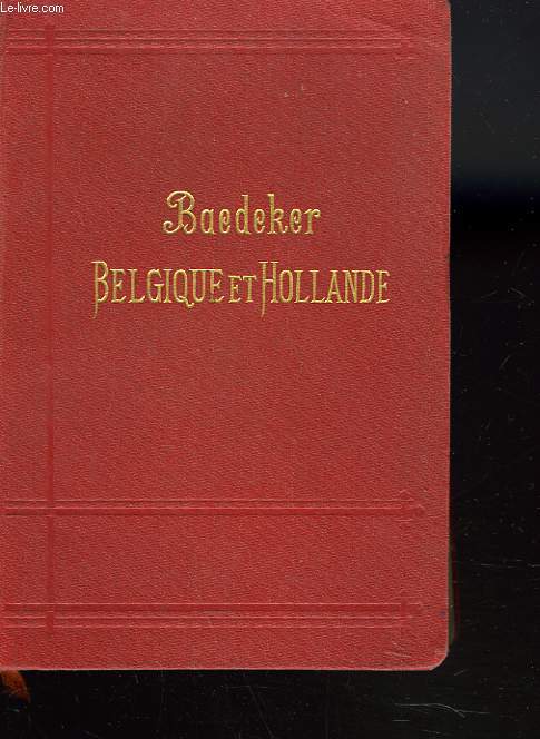
KARL BAEDEKER
BELGIQUE ET HOLLANDE YCOMPRIS LE LUXEMBOURG. MANUEL DU VOYAGEUR
BAEDEKER / OLLENDORFF. 1905. In-12. Cartonnage d'éditeurs. Etat d'usage, Couv. légèrement passée, Dos satisfaisant, Intérieur frais. 480 pages. Nombreuses cartes dépliantes en couleurs.. . . . Classification Dewey : 912-Atlas, cartes et plans
书商的参考编号 : R260113402
|
|
|
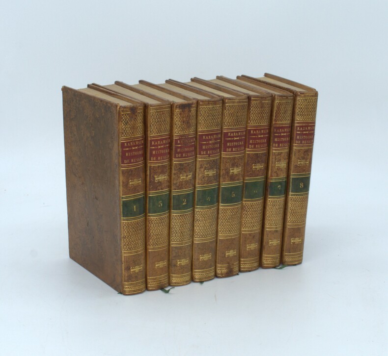
KARAMSIN, Nikolai Michailowitsch , ST. THOMAS , JAUFFRET (traducteurs)
Histoire de l'Empire de Russie. Traduite par MM. St.-Thomas et Jauffret
Paris, de l'imprimerie de A. Bélin, 1819 -1820 , 8 volumes in-8, relié pleine basane racinée, dos lisse avec pièce d’auteur et titre rouge et tomaison verte , tranches mouchetées jaunes, ex-libris au premier plat, trou de vers au tome 2 .
书商的参考编号 : PHO-1477
|
|
|
Karl Zieler Jacobis Atlas Der Hautkrankheiten
Lehrbuch und Atlas der Haut un Geschlechtskrankheiten für praktische Ärzte und Studierende. Auf Grundlage von Prof. Jacobis Atlas der Hautkrankheiten textlich vollständig neu bearbeitet I. Band: Text
Urban & Schwarzenberg 1934 in4. 1934. Cartonné.
书商的参考编号 : 100130229

|
|
|
KARL MULLER ( CAROLUS MULLERUS )
Strabonis Geographicorum Tabulae XV
1858 Paris, Firmin Didot 1858. In-8 broché,sans couvertures, IXp + 15 planches cartes dépliantes en couleurs. Peu courant. Bon état.
书商的参考编号 : 21467
|
|
|
Karl Heussi und Hermann Mulert
Atlas zur Kirchengeschichte. 66 Karten auf 12 Blättern. Zweite durchgelesehene Auflage.
Tübingen, Verlag von J.C.B.Mohr (Paul Siebeck), 1919. origi.Pappband, kl.4°, 18 Seiten und 12 Sätze im Anhang.
书商的参考编号 : 48583
|
|
|
KARL PEUCKER, (1859-1940).
[MAP] Karte von Bulgarien mit Ostrumelien und Tu?rk. Thrakien.; Mit kartographischen und statistischen Beilagen zum Versta?ndnis der orientalischen Krise.
Very Good German Original color map. Folded. A stamp of S. H. Weiss, Constantinople. Elephant folio. (82 x 65 cm). In German. Scale: 1/864.000. [MAP] Karte von Bulgarien mit Ostrumelien und Tu?rk. Thrakien.; Mit kartographischen und statistischen Beilagen zum Versta?ndnis der orientalischen Krise. Showing Bulgaria, Balkans, and Eastern Roumeli, and Turkish / Ottoman Thrace. A rare map. OCLC: 43528174.
|
|
|
Kast, Alfred (Hrsg. von Fraenkel, Eugen / Rumpel, Theodor)
Pathologisch-anatomische Tafeln nach frischen Präparaten
Leipzig, Verlag von Dr. Werner Klinkhardt, 1909. Gr.2°; Je Lieferung 4 Folio-Farbtafeln auf Kunstdruckpapier und Erläuterungen in Quartformat, in getrennter bzw. ohne Zählung (insg. 304 Seiten); [7 Warenabbildungen] ungebunden, in Originalmappe Halbleinen-Mappen lichtrandig, an Gelenken etwas angerissen; Innenbezug leiht stockfleckig; Papier der Begleittexte leicht gebräunt, vereinzelt stockfleckig; einzelne Tafeln fingerfleckig, meist sauber
书商的参考编号 : 56257

|
|
|
KATIB ÇELEBI (Haci Khalfa), (1609-1657).
The gift to the great ones on naval campaigns. (Tuhfetü'l-kibâr fi esfâri'l-bihâr). Edited by Idris Bostan. [With a CD].
New New English Original bdg. Dust wrapper. Folio. (32 x 25 cm). Edition in English. 463, [1] p., color ills. The gift to the great ones on naval campaigns. (Tuhfetü'l-kibâr fi esfâri'l-bihâr). Edited by Idris Bostan. [With a CD]. "It's a cost a joy of that the interest shown to the history and culture of sea has increased recently. If the sciencetific level of this interest is maintained, then how the Turks managed the seas in the best way will be understood better because each state grows to the extent of its interest in the seas and its power in the seas, and it takes its place among the navigator states thanks to the consciousness it develops". OTTOMANIA Ottoman history Military history Navigation Turkish naval forces Manuscript Atlas Map Collection Miniature Turkish and Islamic arts.
|
|
|
KATIP ÇELEBI, (Hadji Khalfa).
The book of Cihannuma: A 360 year old story.= Cihannüma: 360 yillik bir öykü. Edited by Bulent Özükan. Texts by Ibrahim Müteferrika, Orhan Kologlu, Mustafa Kaçar. English by Füsun Savci.
New New English Original bdg. Dust wrapper. In special publisher's box. 4to. (33 x 33 cm). In English and Turkish. 204 p., color ills., maps. The book of cihannuma: A 360 year old story.= Cihannüma: 360 yillik bir öykü. Edited by Bulent Özükan. Texts by Ibrahim Müteferrika, Orhan Kologlu, Mustafa Kaçar. English by Füsun Savci. A very heavy volume. 1950 copies were printed. OTTOMANIA First printing house Ottoman culture Collection Map Atlas World map.
|
|
|
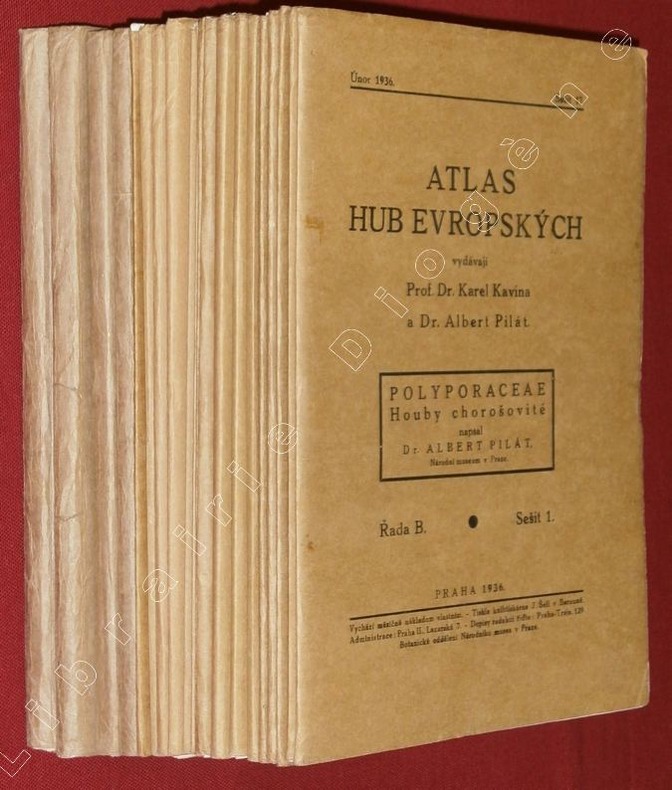
KAVINA, Karel - PILAT, Albert.
[Atlas des champignons de l'Europe]. Atlas Hub Evropskych : Polyporaceae, Houby chorosovité napsal Dr Albert Pilat. (20 fascicules)
Praha (Prague), 1936-42, 20 fascicules in-8 de 160x240 mm environ, 624 pages en 48 livraisons, accompagnées de 374 planches en noir et blanc (2 planches supplémentaires dans le fascicule 13-14), en feuillets sous chemises imprimées, réunies dans une chemise amateur cartonnée orange avec titres manuscrits. Edition originale. Texte en langue tchèque. Des plis sur le dos des 3 dernières chemises qui ont aussi les bordures fendillées, sinon bon état.
书商的参考编号 : 88917
|
|
|
Kayser, Heinrich
Lehrbuch der Spektralanalyse. Mit 87 Holzschnitten im Text und 9 lithogr. Tafeln.
Springer Verl. Berlin 1883. 23,1 : 15,1 cm. Originalhalbleinenband, etwas angestaubt, der hintere Deckel mit größeren (Fett-?)Flecken. XI, 358, (2) Seiten mit den 87 Textabbildungen und anhängend neun lithographierte Tafeln. Bezugspapier im vorderen Innengelenk gerissen, Bindung aber nur wenig gelockert. Im Innenbereich sauber, frei von Eintragungen. Die letze Tafel mittig auf der Rückseite stabilisiert. Gutes Exempar.
书商的参考编号 : 316098

|
|
|
 ?????????
 ?????PDF???
 RSS feed


