|
|
|
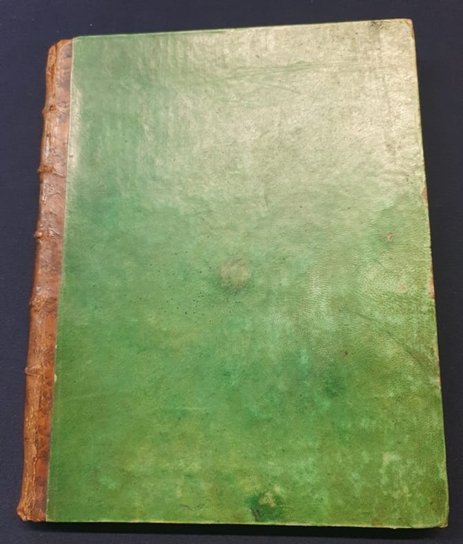
Joseph Jérome Le François de Lalande
Atlas seul du Voyage d'un François en Italie fait dans les années 1765 et 1766 ( 22 cartes et plans )
1769 Atlas Seul - 1 volume In4 plein vélin vert - dos à nerfs - mors supérieur fendu sur 3 cm - Contient 22 planches dépliantes sur 23 ( manque le plan de Nice ) le tout monté sur onglets . Il s'agit de l'atlas de la 1ere édition de 1769 paru chez Dessaint à Paris qui comporte 8 volumes de texte que nous n'avons pas . Joseph Lalande ( 1732/1807) fut l'astronome le plus connu de l'époque .
Référence libraire : Arm362-CB23
|
|
|
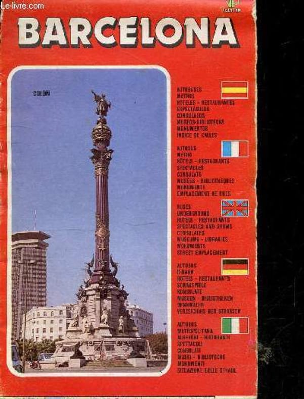
JOSEP NIN I CATALA - COLLECTIF
Barcelona - edition francaise - emplacement des rues et places, lignes du metro et autobus, hotels restaurants et spectacle, consulats, musees, bibliotheques, monuments
DISTRIMAPAS TELSTAR. 1989. In-8. En feuillets. Etat d'usage, Couv. convenable, Dos satisfaisant, Quelques rousseurs. Carte en couleur, dépliante, d'environ 86 x 60 cm. . . . Classification Dewey : 912-Atlas, cartes et plans
Référence libraire : RO20258058 ISBN : 848676405

|
|
|
JOSEP NIN I CATALA - COLLECTIF
Barcelona - en francais, espagnol, allemand, anglais, italien - emplacement des rues et places, lignes du metro et autobus, hotels restaurants et spectacle, consulats, musees, bibliotheques, monuments
DISTRIMAPAS TELSTAR. 1987. In-8. En feuillets. Etat d'usage, Couv. légèrement passée, Dos satisfaisant, Papier jauni. Carte en couleur, dépliante, d'environ 1m10 x 86cm - pliures parfois frottées. . . . Classification Dewey : 912-Atlas, cartes et plans
Référence libraire : RO20258059
|
|
|
Joseph Nicholas MASSE
PETIT ATLAS COMPLET D'ANATOMIE DESCRIPTIVE DU CORPS HUMAIN, destiné à compléter les Traités d'Anatomie Descriptive; par J. - N. Masse, docteur en médecine, professeur d'anatomie. Ouvrage adopté par le Conseil royal de l'Instruction publique.
paris J.B.BAILLIERE, MEQUIGNON-MARVIS 1852 -in-12 pleine percale un volume, reliure d'époque cartonnée pleine percaline saumon in-douze Cartonnage Editeur (hard-back in-12 Editor)(19,2 x 13,4 cm), dos décoré "or" et à froid (gilt and blind stamping decoration), dos légèrement insolé, plats trés légèrement tachés, Auteur, Titre Date d'Edition, lieu d'édition et nom de l'Editeur frappés "or" dans un décor à froid (plaques spéciales editeur), plats décorés à froid (plaques spéciales Editeur), toutes tranches lisses, gardes jaunes, orné de 113 planches hors-texte en couleurs avec 1 page de texte en regard + 6 pages de tables + 36 pages de catalogue de l'Editeur Baillière in-fine, 1852 Paris J.B.BAILLIERE, MEQUIGNON-MARVIS Editeurs,
Référence libraire : 25963
|
|
|
Joseph A. F. Cardiff Creator Atlas Portland Cement Company Creator
Early Stucco Houses.
Nabu Press 2011-11-07. Paperback. Good. Nabu Press paperback
Référence libraire : SONG1271465051 ISBN : 1271465051 9781271465057
|
|
|
Joseph B. Michelson; Joseph B Color Atlas of Uveitis Diagnosis Michelson
A Colour Atlas of Uveitis
Mosby-Year Book 1991-11. Hardcover. Good. Mosby-Year Book hardcover
Référence libraire : SONG0815158998 ISBN : 0815158998 9780815158998
|
|
|
JOURNAUX André
Atlas Mondial
Hatier. 1969. In-4. Relié toilé. Bon état, Couv. convenable, Dos satisfaisant, Intérieur frais. 188 pp., nombreuses cartes couleur hors texte.. . . . Classification Dewey : 912-Atlas, cartes et plans
Référence libraire : ROD0039213
|
|
|
JOURNAUX André
Atlas mondial, l'Europe et l'URSS
Hatier. 1968. In-4. Broché. Bon état, Couv. convenable, Dos satisfaisant, Intérieur frais. 65p, illustré de cartes couleurs.. . . . Classification Dewey : 912-Atlas, cartes et plans
Référence libraire : RO20016728
|
|
|
JOURNAUX ANDRE
ATLAS MONDIAL - Geographie générale - L'Afrique . (ouvrage publicitaire).
HATIER. 1968. In-4. Broché. Bon état, Couv. convenable, Dos satisfaisant, Intérieur frais. Environ 20 pages de cartes en couleur.. . . . Classification Dewey : 912-Atlas, cartes et plans
Référence libraire : R320109226
|
|
|
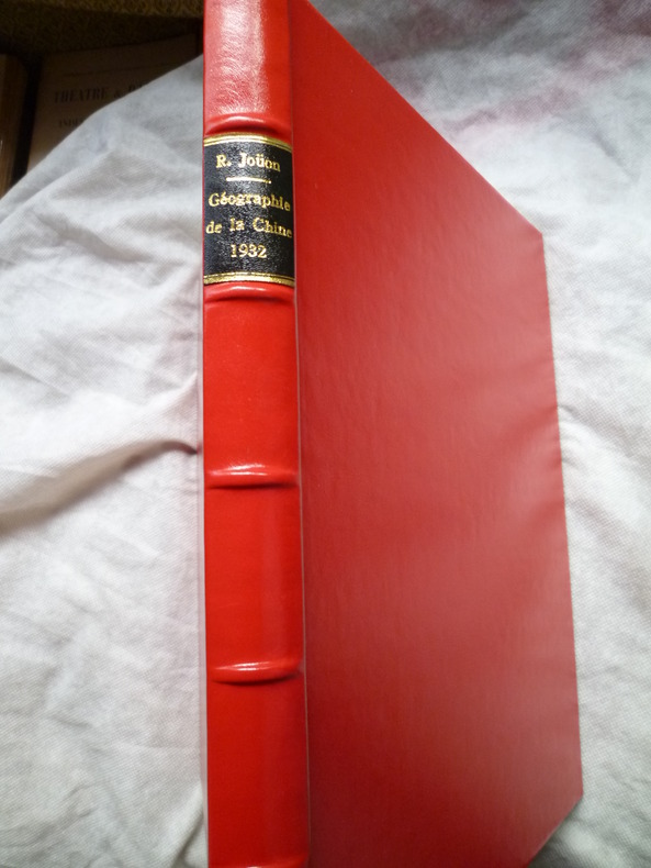
JOUON (René S.J.)
Géographie de la Chine
Shanghaï, Imprimerie de l'Orphelinat de T'ou-Sè-Wè, Zi-Ka-Wei, 1932. 1 volume in-4, 82 pp., couverture originale cartonnée illustrée d'une jonque de Canton, enrichi de très nombreuses cartes en couleurs à pleine page, de plans, diagrammes, tableaux et dessins, reliure moderne plein cuir rouge, très bon état.
Référence libraire : 1118
|
|
|
JOUON (René S.J.)
Géographie de la Chine
Shanghaï, Imprimerie de l'Orphelinat de T'ou-Sè-Wè, Zi-Ka-Wei, 1930 (deuxième édition). 1 volume in-4, 68 pp., couverture souple illustrée d'une jonque de Canton, enrichi de très nombreuses cartes en couleurs à pleine page, de plans, diagrammes, tableaux et dessins, très bon état.
Référence libraire : 11292
|
|
|
JOUON (René S.J.)
Géographie de la Chine
Shanghaï, Imprimerie de l'Orphelinat de T'ou-Sè-Wè, Zi-Ka-Wei, 1932 (troisième édition). 1 volume in-4, 82 pp., couverture originale cartonnée illustrée d'une jonque de Canton, enrichi de très nombreuses cartes en couleurs à pleine page, de plans, diagrammes, tableaux et dessins, reliure moderne plein cuir rouge, très bon état.
Référence libraire : 11293
|
|
|
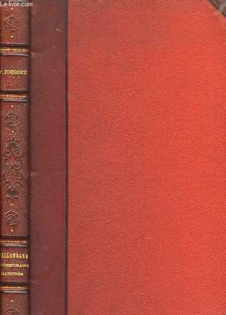
JOUSSET P.
L'Allemagne contemporaine illustrée
LAROUSSE. Non daté. In-4. Relié cuir dos-coins. Bon état, Couv. convenable, Dos satisfaisant, Intérieur frais. 282 pages. Nombreuses photos et illustrations, en noir et blanc, dans le texte. Quelques planches de cartes en couleurs, hors-texte. Lettrines. Titre et filets dorés sur le dos cuir rouge, à 4 nerfs. Coins cuir rouge.. . . . Classification Dewey : 912-Atlas, cartes et plans
Référence libraire : RO80048981
|
|
|
JOURNAUX André
Atlas Mondial.
Reliure de l'éditeur. 188 pages. 23x34cm.
|
|
|
Jousset ( P. )
LA FRANCE Géographie illustrée
français Paris, Librairie Larousse, sans date. 2 vol. in-quarto de (3) ff., 390 pp., (1) ff. - (2) ff., 464 pp.; demi-chagrin marron, plats toilés verts, titres en lettres dorées, tranches rouges ( reliure éditeur ornée de décors estampés à froid ). Tome I : 28 planches hors texte.- 21 cartes et plans en noir et en couleurs. 871 reproductions photographiques. Tome II : 19 planches hors texte. - 29 cartes et plans en noir et en couleurs. 1071 reproductions photographiques. Bon exemplaire bien conservé.
|
|
|
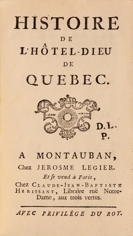
JUCHEREAU DE LA FERTE, dite de Saint-Ignace, Jeanne-Françoise.
Histoire de l’Hôtel-Dieu de Québec. Edition originale de ces annales retraçant le récit de la création à Québec du premier hôpital par les Hospitalières de Dieppe sous les auspices de la duchesse d’Aiguillon, nièce du cardinal de Richelieu.
« Ces annales sont un des documents historiques les plus précieux que l’on possède. » Montauban, chez Jerosme Legier, et se vend à Paris, chez Claide-Jean-Baptiste Herissant, s.d. [1752].In-12 de (8) ff., 556 pp., (1) f. Veau brun, filet à froid autour des plats, dos à nerfs orné de fleurons dorés, coupes décorées, tranches mouchetées. Reliure de l’époque.162 x 91 mm.
Référence libraire : LCS-18112
|
|
|
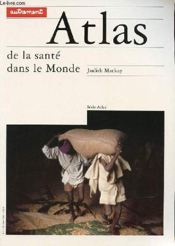
JUDITH MACKAY
"SERIE ""ATLAS"" N°3 - ATLAS DE LA SANTE DANS LE MONDE"
AUTREMENT. OCTOBRE 1993. In-12. Broché. Bon état, Couv. convenable, Dos satisfaisant, Intérieur frais. 136 pages. Nombreuses cartes en couleurs hors texte.. . . . Classification Dewey : 912-Atlas, cartes et plans
Référence libraire : RO30101606
|
|
|
Jugoslawien - ZIVKOVIC, Sinisa
Jugoslovenske zemlje na starim geografskim kartama - 16, 17, 18. vek. Biblioteka Svet umetnosti.
Narodna biblioteka Srbije. NIP Jugoslavija EKO, Beograd 1990. 99, (1) pages. With 40 facs. maps in colour. Embossed orginal leather binding (A little rubbed). 38x29 cm
Référence libraire : 138608

|
|
|
Juillard (Etienne)
L'Alsace et la Lorraine.
Paris Flammarion 1977 Atlas et géographie de la France moderne. Un volume in-4 relié plein simili brun de l'éditeur sous jaquette illustrée, 287 pages. Bel état.
Référence libraire : 1955
|
|
|
Juillard (Etienne)
La vie rurale dans la plaine de Basse-Alsace. Essai de géographie sociale.
français Paris - Stasbourg, Editions F.-X. Le Roux, 1953. Grand in-8 de 582 pp. + 4 cartes h.t.; broché, couverture imprimée, sous jaquette illustrée. Publications de l'Institut des Hautes Etudes Alsaciennes. Tome IX. Très bon état.
|
|
|
Julie Atlas
The Falcon Five
lulu.com. Paperback. GOOD. Spine creases wear to binding and pages from reading. May contain limited notes underlining or highlighting that does affect the text. Possible ex library copy that’ll have the markings and stickers associated from the library. Accessories such as CD codes toys may not be included. lulu.com paperback
Référence libraire : 3190103597 ISBN : 0557571723 9780557571727
|
|
|
Jung Hans-Ulrich, Schätzl Ludwig
Atlas zur Wirtschaftsgeographie von Niedersachsen - Ökonomische, soziale und ökologische Aspekte räumlicher Strukturen und Entwicklungen herausgegeben von der Niedersächsischen Landeszentrale für politische Bildung
Hannover (Niedersächsische Landeszentrale für politische Bildung) 1993 (= Erste Ausgabe). 4°, illustrierte Originalbroschur ( Paperback) 268 S., zahlreiche Kartenskizzen, ISBN 392670117x 1
Référence libraire : Khe04064 ISBN : 392670117
|
|
|
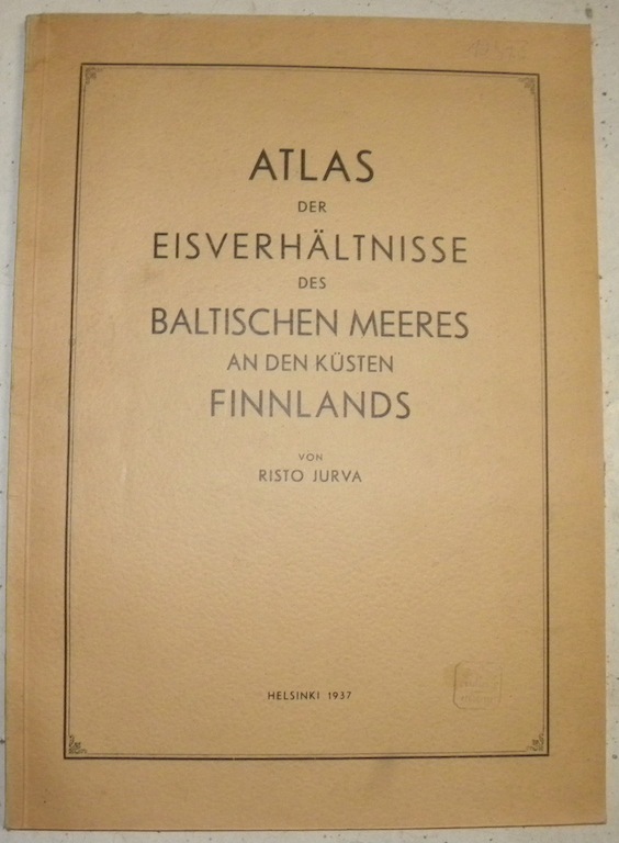
JURVA, Risto.
Atlas der Eisverhältnisse des Baltischen Meeres an den Küsten Finnlands.
Helsinki, Kirjapaino 1937, 410x295mm, 51Seiten, 102 Karten, broschiert.
Référence libraire : 10473
|
|
|
Jwan DANIELOW; Tranquillo MOLLO:
CARTE DES EUROPÄISCH- UND EINES THEILS DES ASIATISCH-RUSSISCHEN REICHS (…) Map engraved on 14 copper plates, mounted on cloth on 12 numbered card sheets (2 supplements attached on sheets nos. 6- and 11), with typographical parallel title in German and French, pictorial legend, notes on transcription of Russian characters in German, as well as graphic scale (ca. 1:2.200.000) in German geographical miles and verst.
Rare and highly detailed map of Western Russia from the Baltic to the Ural Mountains and the Caspian, published in large size by Tranquillo Mollo, one of Beethoven's early Vienna publishers, on the eve of Napoleon's invasion of Russia in 1812. – Content: Present hachure map was drawn by Russian cartographer Ivan Danielov (or Danilov) „according to the latest astronomical localisations, the large atlas and other maps of the Russian Imperial Map Depository, divided into governorates, with borders according to the last peace treaties, furthermore mentioning the postal roads and other main roads also quoting the distances between locations.“ (subtitle). It was printed and edited by Tranquillo Mollo, a Vienna based company specialised in engraved views, maps and sheet music, who in those years also functioned as one of Beethoven's earliest publishers. Danielov's map „may have appeared just in time to be offered as 'theatre of war' in connection with Napoleon's Russian campaign. This map, which covers the area between Danzig and Tobolsk and between the Kara Strait and Armenia respectively, presents, as a contemporary review puts it, 'without being overloaded [...] all of the considerable places, mountains, rivers, lakes, etc. of the Russian Empire and the bordering parts of it with great detail, and is rightly preferable to all previously published theatres of war, since for its other completeness it includes Astrakhan and Tobolsk, whereas the latter often do not even go as far as Moscow, and is therefore to be recommended as a very useful aid to anyone who wants to follow the history of the present war'". (Dörflinger) – Condition: Separate outline map missing as usual. Some segments in parts very slightly stained, otherwise well preserved map indeed, particularly protected due to the contemporary cardboard wrapper and slipcase. – Rarity: Particularly scarce in present fresh condition, JAP/APO and RBH quote only 3 copies at auction since 1950, of them with the outline map. – Reference: Dörflinger II, p. 463: Mol 39. Tooley I, 332 (without supplements); Durstmüller I, p. 190 (Mollo).
|
|
|
K.u.k. MILITAR-GEOGRAPHISCHEN INSTITUT.
[MAP of BALKANS] 40-44 Zajecar. [Macedonia, Donau -Danube- River, Hungary and Bulgaria border, East Serbia].
Very Good German Original color map on cloth. A little foxing on cloth. Very good. Folded. Folio. (57 x 43 cm). Toponyms in German. [MAP of BALKANS] 40-44 Zajecar. [Macedonia, Donau -Danube- River, Hungary and Bulgaria border, East Serbia].
|
|
|
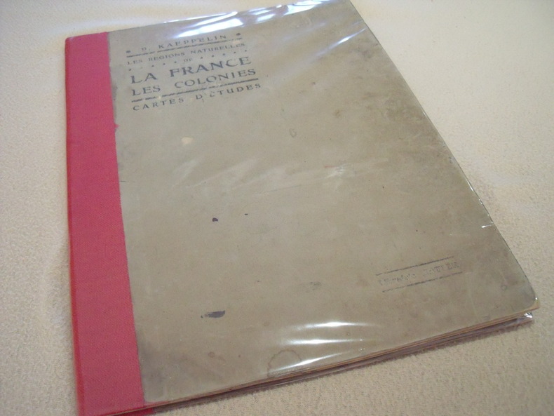
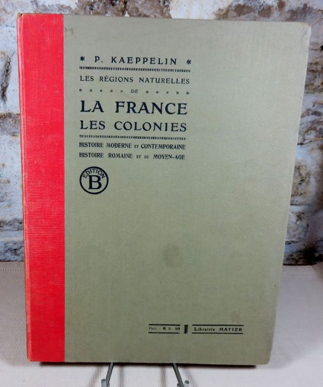
Kaeppelin . P.
Les Régions Naturelles De La France et Les Colonies -Cartes D'Etudes
Librairie Hatier - Rue D' Assas - Paris - Sans date vers 1900 - 36 pages non foliotées - Histoire Romaine et du Moyen-Age du V ème au X ème siècles - Histoire moderne et contemporaine - Cartes géographiques et historiques à l'usage des classes de première - Etat convenable .
Référence libraire : Atlas1900
|
|
|
KAEPPELIN P.
Les régions naturelles de la France. Les colonies. Histoire Romaine et du Moyen-Age du Ve au Xe siècle Histoire Moderne et Contemporaine à l'usage des classes de première.
Cartonnage éditeur dos toile, 37X28 cm, sans date (mention de 4° ed), 40 pages, cartes en couleurs, librairie Hatier. Bon exemplaire.
Référence libraire : 13360
|
|
|
Kaemling, Werner
Atlas zur Geschichte Niedersachsens.
Braunschweig., Gerd J. Holtzmeyer Verlag., 1987. 119 Seiten Karten und Skizzen mit Erläuterungen. Guter Zustand - ohne Mängel. Quer-gr.-8°. OPappband.
Référence libraire : 021042
|
|
|
Kaeppelin (P.)
Géographie. Cours moyen et supérieur, Certificat d'études, classe de septième des lycées et collèges. La France et ses colonies. Les cinq parties du monde.
français Sans date (circa 1931). In-4 de (2)-88 pp.; album cartonné de l'éditeur, dos toilé vert. Nouvelle édition revue et mise à jour par A. Leyritz. Avec illustrations en noir et cartes en couleurs. Quelques mots manuscrits dans les feuillets.
|
|
|
Kaeppelin (P.)
Les régions naturelles de la France. - Les colonies.
français Sans date. In-folio de 27 pp.; album demi-toile de l'éditeur. 4e édition. Cartes en couleurs.
|
|
|
KAISERLICH un KÖNIGLICHES MILITAR-GEOGRAPHISCHES INSTITUT].
[MAP of ROMANIA] P.8. Jassy (Iashi) - Moldau.
Very Good German Original color map on cloth. A little foxing on cloth. Very good. Folded. Oblong folio. (45 x 51 cm). In German. Shows Tirgu Frumos, Jassi, Tzibana, Kodaesti, Brindza, Negresti, Becesti, Pundzesti, Birlaf, Gaiciana, Urdesti, Falci, etc. [MAP of ROMANIA] P.8. Jassy - Moldau. Scale: 1/300000. (Jassy or Iassy) Iasi is the second-largest city in Romania, after the national capital Bucharest, and the seat of Iasi County. Located in the historical region of Moldavia, Iasi has traditionally been one of the leading centers of Romanian social, cultural, academic and artistic life. The city was the capital of the Principality of Moldavia from 1564 to 1859, then of the United Principalities from 1859 to 1862, and the capital of Romania from 1916 to 1918. (Source: Wikipedia). A sheet of the collection of 'The general map of Central Europe'. appeared in the years between 1873-1876 with the work of Joseph Ritter von Scheda, (1815-1888) who was a general, geographer and cartographer.
|
|
|
KAISERLICH un KÖNIGLICHES MILITAR-GEOGRAPHISCHES INSTITUT].
[MAP of WEST GREECE] L.15. Paramythia (Corfu). Jonisches Meer.
Very Good German Original color map on cloth. A little foxing on cloth. Very good. Folded. Oblong folio. (45 x 51 cm). In German. [MAP of WEST GREECE] L. 15. Paramythia (Corfu). Jonisches Meer. Scale: 1/300000. A sheet of the collection of 'The general map of Central Europe'. appeared in the years between 1873-1876 with the work of Joseph Ritter von Scheda, (1815-1888) who was a general, geographer and cartographer.
|
|
|
KAISERLICH un KÖNIGLICHES MILITAR-GEOGRAPHISCHES INSTITUT].
[MAP of WEST GREECE] L.15. Philiataes (Corfu). Jonisches Meer.
Very Good German Original color map on cloth. A little foxing on cloth. Very good. Folded. Oblong folio. (45 x 51 cm). In German. [MAP of WEST GREECE] L.15. Philiataes (Corfu). Jonisches Meer. Scale: 1/300.000. A sheet of the collection of 'The general map of Central Europe'. appeared in the years between 1873-1876 with the work of Joseph Ritter von Scheda, (1815-1888) who was a general, geographer and cartographer.
|
|
|
KAISERLICH un KÖNIGLICHES MILITAR-GEOGRAPHISCHES INSTITUT].
[MAP] K.12. Ragusa, Dubrovnik.
Good German Original color map on cloth. Some tears on foldings. Good. Folded. Oblong folio. (45 x 51 cm). In German. Shows Stolac, Metkovic, Ljubinje, Bilek, Niksic, Trebinje, Ragusa, Meleda Island, Cattaro, et alli. Ragusa is a Croatian city on the Adriatic Sea. It is one of the most prominent tourist destinations in the Mediterranean Sea, a seaport and the centre of Dubrovnik-Neretva County. A sheet of the collection of 'The general map of Central Europe'. appeared in the years between 1873-1876 with the work of Joseph Ritter von Scheda, (1815-1888) who was a general, geographer and cartographer.
|
|
|
KAISERLICH und KÖNIGLISCHES MILITAR-GEOGRAPHISCHES INSTITUT].
[MAP of OTTOMAN BALKANS] L.14. Berat (Argyrokastro).
Very Good German Original color map on cloth. Folded. Oblong folio. (45 x 51 cm). In German. [MAP of OTTOMAN BALKANS] L.14. Berat (Argyrokastro). Shows South Albanian shores, Corfu, Berat et alli. A sheet of the collection of 'The general map of Central Europe'. appeared in the years between 1873-1876 with the work of Joseph Ritter von Scheda, (1815-1888) who was a general, geographer and cartographer.
|
|
|
KAISERLICH und KÖNIGLISCHES MILITAR-GEOGRAPHISCHES INSTITUT].
[MAP] Q.8. Odessa.
Very Good German Original color map on cloth. A little foxing on cloth. Very good. Folded. Oblong folio. (45 x 59 cm). In German. Shows Kujaljnickij Limani, Dnjesstrowskij Liman, Odessa shores and hinterland. Rare. A sheet of the collection of 'The general map of Central Europe'. appeared in the years between 1873-1876 with the work of Joseph Ritter von Scheda, (1815-1888) who was a general, geographer and cartographer.
|
|
|
KAISERLICH-KÖNIGLISCHES MILITAR-GEOGRAPHISCHES INSTITUT].
[MAP of ANATOLIA] O.14. Brussa. [Southern Brussa - Gönen - Manias Göl -Lake-, Anatolien, Abulonia Göl -Lake-].
Very Good German Original color map on cloth. Folded. A good copy. Oblong folio. (45 x 51 cm). In German. [MAP] O.14. Brussa. [Southern Brussa - Gönen - Manias Göl -Lake-, Anatolien, Abulonia Göl -Lake-]. Shows Abhuitis See, Artynia See, Kirmisli Kasaba, etc. A sheet of the collection of 'The general map of Central Europe'. appeared in the years between 1873-1876 with the work of Joseph Ritter von Scheda, (1815-1888) who was a general, geographer and cartographer.
|
|
|
KAISERLICH-KÖNIGLISCHES MILITAR-GEOGRAPHISCHES INSTITUT].
[MAP of BALKANS] J.10. Glina.
Very Good German Original color map on cloth. Oblong atlas folio. (46 x 52 cm). Toponyms in German. [MAP of BALKANS] J.10. Glina and around. North Bosnia and Herzegovina sheet. A sheet of the collection of 'The general map of Central Europe'. appeared in the years between 1873-1876 with the work of Joseph Ritter von Scheda, (1815-1888) who was a general, geographer and cartographer.
|
|
|
KAISERLICH-KÖNIGLISCHES MILITAR-GEOGRAPHISCHES INSTITUT].
[MAP of BOSNIA-HERZEGOVINA / SARAJEVO] K.11. Bosna-Serai.
Very Good German Original color map on cloth. Chipped on folded places. Otherwise a clean copy. Oblong atlas folio. (46 x 52 cm). Scale: 1/300.000. Toponyms in German. Shows Saraybosna (Sarajevo), and its around, Travnik, Kladanj, G. Yakuf, Konjiva, Gorazda, Mostar et alli. A sheet of the collection of 'The general map of Central Europe'. appeared in the years between 1873-1876 with the work of Joseph Ritter von Scheda, (1815-1888) who was a general, geographer and cartographer.
|
|
|
KAISERLICH-KÖNIGLISCHES MILITAR-GEOGRAPHISCHES INSTITUT].
[MAP of BULGARIA] O.11. Rusçuk. [Ruse]. Donau River, Plevna, Nikoli.
Very Good German Original color map on cloth. Folded. A good copy. Oblong folio. (45 x 51 cm). In German. [MAP of BULGARIA]. Rusçuk. [Ruse]. Donau River, Plevna, Nikoli. A sheet of the collection of 'The general map of Central Europe'. appeared in the years between 1873-1876 with the work of Joseph Ritter von Scheda, (1815-1888) who was a general, geographer and cartographer.
|
|
|
KAISERLICH-KÖNIGLISCHES MILITAR-GEOGRAPHISCHES INSTITUT].
[MAP of BULGARIA] Q.10. Küstendze (Constanta). Bulgaria. Schwarzes Meer (Black Sea).
Very Good German Original color map on cloth. Folded. Oblong folio. (45 x 51 cm). In German. [MAP] Q.10. Küstendze (Constanta). Bulgaria. Schwarzes Meer (Black Sea). A sheet of the collection of 'The general map of Central Europe'. appeared in the years between 1873-1876 with the work of Joseph Ritter von Scheda, (1815-1888) who was a general, geographer and cartographer.
|
|
|
KAISERLICH-KÖNIGLISCHES MILITAR-GEOGRAPHISCHES INSTITUT].
[MAP of CENTRAL ALBANIA] L.13. Durazzo.
Very Good German Original color map on cloth. Chipped on folded places. It needs repair. Oblong atlas folio. (46 x 52 cm). Toponyms in German. Shows Durach (Durazzo) and its around, Musakija at south, western shores of Albania, Elbasan, and three bays (Drin Golf etc). A sheet of the collection of 'The general map of Central Europe'. appeared in the years between 1873-1876 with the work of Joseph Ritter von Scheda, (1815-1888) who was a general, geographer and cartographer.
|
|
|
KAISERLICH-KÖNIGLISCHES MILITAR-GEOGRAPHISCHES INSTITUT].
[MAP of CROATIA] K.10. Brood.
Very Good German Original color map on cloth. Chipped on folded places. Otherwise a clean copy. Oblong atlas folio. (46 x 52 cm). Toponyms in German. Shows Brood area and its around, Djakovo, Tuzla etc. A sheet of the collection of 'The general map of Central Europe'. appeared in the years between 1873-1876 with the work of Joseph Ritter von Scheda, (1815-1888) who was a general, geographer and cartographer.
|
|
|
KAISERLICH-KÖNIGLISCHES MILITAR-GEOGRAPHISCHES INSTITUT].
[MAP of GALLIPOLI]. P.14. Gallipoli [and Edremid Gulf, Imbros, Tenedos, Lesbos (Midilli), Aivali (Ayvalik) and North Aegean shores of Anatolia].
Very Good German Original color map on cloth. Chipped on folded places. Otherwise a clean copy. Oblong atlas folio. (46 x 52 cm). Scale: 1/300.000. Toponyms in German. Shows Gallipoli [and the Hellespont, Edremid Gulf, Imbros, Tenedos, Lesbos (Midilli), Aivali (Ayvalik) and North Aegean shores of Anatolia]. A sheet of the collection of 'The general map of Central Europe'. appeared in the years between 1873-1876 with the work of Joseph Ritter von Scheda, (1815-1888) who was a general, geographer and cartographer.
|
|
|
KAISERLICH-KÖNIGLISCHES MILITAR-GEOGRAPHISCHES INSTITUT].
[MAP of GREECE] N.14. Salonik (Salonica - Thessaloniki - Salonique). Platamora, Aegaisches Meer, Larissa.
Very Good German Original color map on cloth. Folded. A good copy. Oblong folio. (45 x 51 cm). In German. [MAP of GREECE] N.14. Salonik (Salonica - Thessaloniki - Salonique). Platamora, Aegaisches Meer, Larissa. A sheet of the collection of 'The general map of Central Europe'. appeared in the years between 1873-1876 with the work of Joseph Ritter von Scheda, (1815-1888) who was a general, geographer and cartographer.
|
|
|
KAISERLICH-KÖNIGLISCHES MILITAR-GEOGRAPHISCHES INSTITUT].
[MAP of GREECE] N.15. Phersala [Farsala]. Gulf von Volo, Canal v. Triche, I. Egripo (Euboea, Evvia), Canal Orei, Kirtzini Armiro, Chalkis, etc.
Very Good German Original color map on cloth. Folded. A good copy. Oblong folio. (45 x 51 cm). In German. [MAP of GREECE] N.15. Phersala [Farsala]. Gulf von Volo, Canal v. Triche, I. Egripo (Euboea, Evvia), Canal Orei, Kirtzini Armiro, Chalkis, etc. A sheet of the collection of 'The general map of Central Europe'. appeared in the years between 1873-1876 with the work of Joseph Ritter von Scheda, (1815-1888) who was a general, geographer and cartographer.
|
|
|
KAISERLICH-KÖNIGLISCHES MILITAR-GEOGRAPHISCHES INSTITUT].
[MAP of OTTOMAN BALKANS] 0.13. Xanthi. [Northern Greece - Western Thrace] Iskeçe.
Very Good German Original color map on cloth. Folded. A good copy. Oblong folio. (45 x 51 cm). In German. [MAP of OTTOMAN BALKANS] 0.13. Xanthi. [Northern Greece - Western Thrace] Iskeçe. A sheet of the collection of 'The general map of Central Europe'. appeared in the years between 1873-1876 with the work of Joseph Ritter von Scheda, (1815-1888) who was a general, geographer and cartographer.
|
|
|
KAISERLICH-KÖNIGLISCHES MILITAR-GEOGRAPHISCHES INSTITUT].
[MAP of OTTOMAN BALKANS] 0.13. Xanthi. [Northern Greece - Western Thrace]. Iskeçe.
Very Good German Original color map on cloth. Folded. A good copy. Oblong folio. (45 x 51 cm). In German. [MAP of OTTOMAN BALKANS] 0.13. Xanthi. [Northern Greece - Western Thrace]. Iskeçe. A sheet of the collection of 'The general map of Central Europe'. appeared in the years between 1873-1876 with the work of Joseph Ritter von Scheda, (1815-1888) who was a general, geographer and cartographer.
|
|
|
KAISERLICH-KÖNIGLISCHES MILITAR-GEOGRAPHISCHES INSTITUT].
[MAP of OTTOMAN BALKANS] L.12. Durazzo. Vilajet Scutari - Nord Albanien - Prizren. [Scutari Province - North Albania].
Very Good German Original color map on cloth. Folded. A good copy. Oblong folio. (45 x 51 cm). In German. [MAP of OTTOMAN BALKANS] L.12. Durazzo. Vilajet Scutari - Nord Albanien - Prizren. [Scutari Province - North Albania]. A sheet of the collection of 'The general map of Central Europe'. appeared in the years between 1873-1876 with the work of Joseph Ritter von Scheda, (1815-1888) who was a general, geographer and cartographer.
|
|
|
KAISERLICH-KÖNIGLISCHES MILITAR-GEOGRAPHISCHES INSTITUT].
[MAP of OTTOMAN BALKANS] L.13. Durazzo. Vilajet Scutari - Mittel Albanien. [Scutari Province - Middle Albania].
Very Good German Original color map on cloth. Folded. A good copy. Oblong folio. (45 x 51 cm). In German. [MAP of OTTOMAN BALKANS] L.13. Durazzo. Vilajet Scutari - Mittel Albanien. [Scutari Province - Middle Albania]. Turkish toponyms in German. A sheet of the collection of 'The general map of Central Europe'. appeared in the years between 1873-1876 with the work of Joseph Ritter von Scheda, (1815-1888) who was a general, geographer and cartographer.
|
|
|
 Recevoir par e-mail
 Télécharger en PDF
 Flux RSS


