|
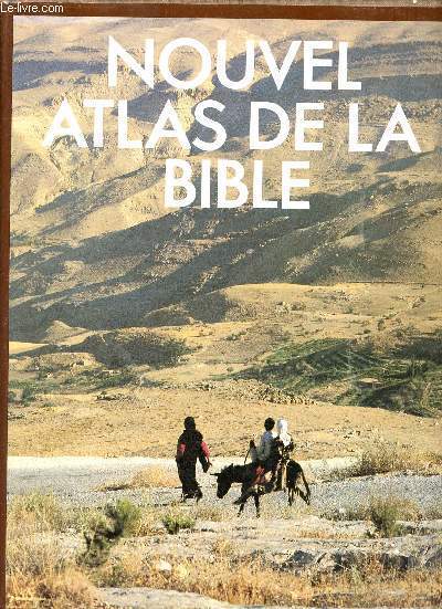
ROGERSON John
Nouvel Atlas de la Bible
Editions du Fanal 1987 237 pages in-4. 1987. Cartonné/Jaquette. 237 pages. Nombreuses illustrations en noir et en couleurs
Référence libraire : 16959
|
|
|
Rogerson John
Nouvel atlas de la bible.
Editions du Fanal. 1987. In-4. Relié. Bon état, Couv. convenable, Dos satisfaisant, Intérieur frais. 237 pages - jaquette en bon état - nombreuses photos et cartes en couleurs dans et hors texte.. Avec Jaquette. . . Classification Dewey : 912-Atlas, cartes et plans
Référence libraire : R320144569
|
|
|
ROGERSON John
Nouvel atlas de la Bible.
Paris, Editions du Fanal, 1987 24 x 31, 236 pp., 27 plans et schémas, 43 cartes, plus de 350 illustrations dont 285 en couleurs, cartonnage éditeur + jaquette, très bon état
Référence libraire : 12528
|
|
|
Rogerson, John
Land der Bibel: Kunstgeschichte und Lebensformen.
Augsburg, Bechtermünz 1997. 4°. 237 S. reich illustriert, OPpbd., neuwertig.
Référence libraire : KULT1176
|
|
|
Roggeveen (Arent), Goos (Pieter)
The Burning Fen (The first part -The Second part)
Theatrum Orbis Terranum 1971 2 volumes. Grand in-4 toilé, sous jaquette illustrée. Nombreuses illustrations. facsimile atlas
Référence libraire : 34206
|
|
|
Rohen, Johannes W., Chihiro Yokochi and Elke Lütjen-Drecoll
Color atlas of anatomy : a photographic study of the human body. ; Chihiro Yokochi ; Elke Lütjen-Drecoll 5. ed.
Stuttgart : Schattauer; Philadelphia ; Baltimore ; New York ; London ; Buenos Aires ; Hong Kong ; Sydney ; Tokyo : Lippincott, Williams and Wilkins 2002. XII, 500 S. : überw. Ill., graph. Darst. 30*23 cm. OPappband.
Référence libraire : 124250

|
|
|
Rohmeder, [Wilhelm] / Wenz, Gustav
Methodischer Atlas : Ausgabe für Württemberg, Baden und die Hohenzollern'schen Lande : 25 Karten (incl. 8 Doppelblätter) in Farbendruck.
München, Druck und Verlag von R. Oldenbourg, 1886. 4° (33x27), 1 Bl., 33 Kartenblätter, Hldr d.Zt., Originalumschlag mit eingebunden, [2 Warenabbildungen] Rücken und Kanten bestossen, alter Name auf Innenspiegel, Fadenheftung etwas gelockert, Papier durchgehend etwas fleckig, ordentliches Belegexemplar,
Référence libraire : 57341AB

|
|
|
ROLAND (Dr F.), LAFRERY (Antoine)
Un franc-comtois éditeur et marchand d'estampes à Rome au xvie siècle : ANTOINE LAFRERY (1512-1577).
Besançon typographie et lithographie Dodivers 1911 un fascicule grand in-8°, couverture imprimée orange et titrée noire, 88 pp. Cinq planches en noir in fine. Non coupé.
Référence libraire : 021795
|
|
|
ROLAND, J . & DUCHESNE, E .
Atlas-Manuel illustré de Géographie, avec le texte en regard des Cartes.
grand in-8°, 66 pages, 32 cartes en couleurs, illustrations, agrafé, couv. Tres bon etat. [PIL-5][PIL-5-]
|
|
|
ROLAND, J . & DUCHESNE, E .
Atlas-Manuel illustré de Géographie, avec le texte en regard des Cartes.
Namur, Ad. Wesmael-Charlier Editeur, 1905. grand in-8°, 66 pages, 32 cartes en couleurs, illustrations, agrafé, couv.
Référence libraire : 41436
|
|
|
ROLAND, J. - DUCHESNE, E.
Atlas d’Histoire avec Tableaux-Résumés. Cours d’Histoire à l’usage de l’Enseignement moyen. Première Partie : Histoire Universelle jusqu’aux Croisades.
Namur, Ad. Wesmael-Charlier 1908, 275x215mm, 16pages, broché. Petite étiquette sur la page de couverture. Bel exemplaire.
Référence libraire : 21164

|
|
|
Rolf, Anita (Redaktion)
Fahrrad Atlas. Die schönsten Radwanderungen in Deutschland. Touren, Technik, Fitness.
Ostfildern, Mairs Geographischer Verlag, 1991. Orig.-Pappband, 350 Seiten, Gr.-8°. Ganor / Thomae Sonderausgabe (1991). Die schönsten Radwanderungen in Deutschland. Sauberes und sehr gut erhaltenes Exemplar.
Référence libraire : 006165

|
|
|
Rolf, Anita (Redaktion)
Sachs Fahrrad Atlas. Die schönsten Radwanderungen in Deutschland. Touren, Technik, Fitness.
Ostfildern, Mairs Geographischer Verlag, 1994. Orig.-Pappband, 446 Seiten, Gr.-8°. Die schönsten Radwanderungen in Deutschland. Sauberes und sehr gut erhaltenes Exemplar.
Référence libraire : 006164

|
|
|
ROLLAND GEORGES
CARTE DE L'AFRIQUE FRANCAISE - en couleurs - Echelle 1/20000000e - de dimension 29 Cm 30 Cm environ / Conference de Garnison du 13 mars 1897.
NON PRECISE. 1897. In-Plano. En feuillets. Etat d'usage, Couv. convenable, Dos satisfaisant, Intérieur acceptable. 1 CARTE ENCOULEURS DE DIMENSION 29 Cm X 30 Cm ENVIRON. - Nombreuses rousseurs au dos de la carte sans conséquence sur la lecture.. . . . Classification Dewey : 912-Atlas, cartes et plans
Référence libraire : R320059944
|
|
|
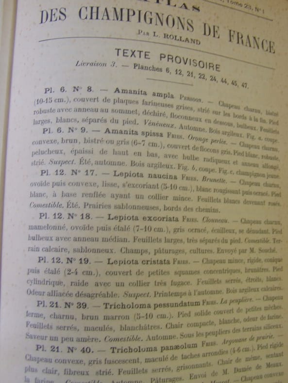
ROLLAND Léon
Atlas des champignons de France,Suisse et Belgique
grand in 8 demi-chagrin marron à nerfs,titre doré,double filet doré sur plats,Faux-titre,titre,126 pages de description,table des matières à la suite 120 planches en chromolithographie d’après les aquarelles de A.BESSIN entièrement montées sur onglets,représentant 283 espèces comestibles vénéneuses
Référence libraire : 8032
|
|
|
ROLLAND Léon. BESSIN A.
Atlas des Champignons de France, Suisse et Belgique. - 120 planches coloriées représentant 283 espèces comestibles, vénéneuses ou remarquables par leur abondance ou leur forme, avec leur description et l'indication de leurs propriétés alimentaires. Aquarelles de A. BESSIN.
1910 Paris. Klincksieck. 1910. Gd et fort in-8 (165 x 250mm) dos chagrin noir à 5 nerfs (frotté), titre, filets et fleurons or, plats teinte jaspés, gardes jaspées, 126, (1) pages de texte et 120 planches couleurs montées sur onglets + Texte provisoire ; Supplements au Bull.de la Soc.Myc. de France tome 22 N°4.- 23 N°1,2,3,tome 24 N°2, tome 25 N°1,2,3, etc- rare état, bel exemplaire, bien relié,mais accident au milieu du dos.Remise de 20% pour toutes commandes égales ou supérieures à 100 €.
Référence libraire : 27075
|
|
|
ROLLIN
ATLAS DE GEOGRAPHIE ANCIENNE, pour servir à l'intelligence des oeuvres de Rollin gravés d'après les cartes originales de d'Anville.
P, Carez, Thomine, Fortic , 1819 , in folio br , 2 p , 14 cartes et gravures à double page. Complet en soi. Contient les 14 planches de l' Histoire romaine.
Référence libraire : M5626
|
|
|
ROLLIN.
Atlas de l’Histoire Ancienne de Rollin.
Sans lieu ni date (1860). Atlas in-4 (27x18cm), relié demi-chagrin et coins, dos à 6 nerfs, coins usés, 24pp de texte, 39 planches et 4 cartes dépliantes. COMPLET. Quelques rousseurs.
Référence libraire : P1-3i-6
|
|
|
ROMAGNESI H.
Petit Atlas des Champignons. 2 vols.
Bordas.1971.2 vols in-12,cartonnage éditeur illustré en couleurs.Pages entières en couleurs de dessins de champignons.BE.Très légères piqùres sur les tranches.
Référence libraire : 40576
|
|
|
ROMAGNESI Henri
Nouvel atlas des champignons, tome III.
Bordas Bordas, 1971, cartonnage éditeur sous jaquette, environ 29x22cm, bon état.
Référence libraire : 114190
|
|
|
ROMAGNY, Charles.
Guerre Franco-Allemande 1870-1871. Atlas comprenant 18 cartes croquis en deux couleurs.
Paris, Limoges, Charles Lavauzelle,( 1891) ; porte-feuille petit in-folio de l'éditeur, demi-toile à coins ocre avec titre imprimé en noir au 1er plat , renfermant 18 cartes .Portefeuille un peu jauni.
Référence libraire : cROU-283
|
|
|
Ron Atlas
Looking for Zebra: Hotel Zoo : Happy Hunting from A to Z
Little Simon. Hardcover. POOR. Noticeably used book. Heavy wear to cover. Pages contain marginal notes underlining and or highlighting. Possible ex library copy with all the markings/stickers of that library. Accessories such as CD codes toys and dust jackets may not be included. Little Simon hardcover
Référence libraire : 3249843746 ISBN : 0671629239 9780671629236
|
|
|
Ron Atlas
Looking for Zebra: Hotel Zoo : Happy Hunting from A to Z
Very Good. Used book in very good condition. Some cover wear may contain a few marks. 100% guaranteed. 062720 unknown
Référence libraire : 0671629239[vg] ISBN : 0671629239 9780671629236
|
|
|
Ron Atlas
Looking for Zebra: Hotel Zoo : Happy Hunting from A to Z
1986-04-02. Good. Ships with Tracking Number! INTERNATIONAL WORLDWIDE Shipping available. May not contain Access Codes or Supplements. May be re-issue. May be ex-library. Shipping & Handling by region. Buy with confidence excellent customer service! unknown
Référence libraire : 0671629239 ISBN : 0671629239 9780671629236

|
|
|
Ron Atlas
Ten Pigs Fiddling
Amberwood Press 2006. Hardcover. Good. Disclaimer:A copy that has been read but remains in clean condition. All pages are intact and the cover is intact. The spine may show signs of wear. Pages can include limited notes and highlighting and the copy can include previous owner inscriptions. At ThriftBooks our motto is: Read More Spend Less.Dust jacket quality is not guaranteed. Amberwood Press hardcover
Référence libraire : G0963024337I3N00 ISBN : 0963024337 9780963024336

|
|
|
Ron Atlas
Ten Pigs Fiddling
Amberwood Press 2006. Hardcover. Good. Disclaimer:A copy that has been read but remains in clean condition. All pages are intact and the cover is intact. The spine may show signs of wear. Pages can include limited notes and highlighting and the copy can include previous owner inscriptions. At ThriftBooks our motto is: Read More Spend Less.Dust jacket quality is not guaranteed. Amberwood Press hardcover
Référence libraire : G0963024388I3N00 ISBN : 0963024388 9780963024381

|
|
|
Ron Atlas Stacie Flint Illustrator
Ten Pigs Fiddling
Amberwood Press 2005-09-15. Hardcover. Used:Good. Amberwood Press hardcover
Référence libraire : DADAX0963024388 ISBN : 0963024388 9780963024381

|
|
|
Ron Atlas; Illustrator Stacie Flint
Ten Pigs Fiddling CD Edition
Amberwood Press Inc 2006-10-28. Hardcover. Good. Amberwood Press, Inc hardcover
Référence libraire : SONG0963024337 ISBN : 0963024337 9780963024336

|
|
|
Ronald M Atlas
Many Faces Many Microbes: Personal Reflections in Microbiology
ASM Press 2000. This is an ex-library book and may have the usual library/used-book markings inside.This book has soft covers. In good all round condition. Please note the Image in this listing is a stock photo and may not match the covers of the actual item550grams ISBN:9781555811907 ASM Press paperback
Référence libraire : 6502052 ISBN : 1555811906 9781555811907

|
|
|
Ronald M. Atlas
Basic and Practical Microbiology
Macmillan Pub Co 1986-01. Hardcover. Good. Macmillan Pub Co hardcover
Référence libraire : SONG0023043504 ISBN : 0023043504 9780023043505
|
|
|
Ronald M. Atlas Jim Philp
Bioremediation: Applied Microbial Solutions for Real-World Environment Cleanup
Good. No Hassle 30 Day Returns Ships Daily Underlining/Highlighting: NONE Writing: None unknown
Référence libraire : 6327621 ISBN : 1555812392 9781555812393

|
|
|
Ronald M. Atlas Editor Jim Philp Editor
Bioremediation: Applied Microbial Solutions for Real-World Environment Cleanup
Amer Society for Microbiology 2005-05-30. 1. Hardcover. Used:Good. Amer Society for Microbiology hardcover
Référence libraire : DADAX1555812392 ISBN : 1555812392 9781555812393
|
|
|
Ronald M. Atlas
Customized Biology of Disease Bio 107 for Wright State University
Wright State. Used - Good. Shows some signs of wear and may have some markings on the inside. Wright State unknown
Référence libraire : GRP83443929 ISBN : 069742278x 9780697422781
|
|
|
Ronald M. Atlas Alfred E. Brown Kenneth W. Dobra Llonas Miller
Experimental Microbiology Fundamentals And Applications
MacMillan Publishing Company. Used - Good. Shows some signs of wear and may have some markings on the inside. MacMillan Publishing Company unknown
Référence libraire : GRP3307949 ISBN : 0023045302 9780023045301
|
|
|
Ronald M. Atlas; Alfred E. Brown; Kenneth W. Dobra; Lionas Miller
Experimental Microbiology: Fundamentals and Applications 2nd Edition
Benjamin Cummings 1988-02-18. Paperback. Good. Benjamin Cummings paperback
Référence libraire : SONG002304280X ISBN : 002304280X 9780023042805
|
|
|
Ronald M. Atlas
Handbook of Microbiological Media
1993-01-05. New. Ships with Tracking Number! INTERNATIONAL WORLDWIDE Shipping available. May be re-issue. Buy with confidence excellent customer service! unknown
Référence libraire : 0849329442n ISBN : 0849329442 9780849329449

|
|
|
Ronald M. Atlas
Handbook of Microbiological Media for the Examination of Food Second Edition
CRC. Used - Very Good. Great condition for a used book! Minimal wear. CRC unknown
Référence libraire : GRP117328350 ISBN : 0849335612 9780849335617

|
|
|
Ronald M. Atlas
Handbook of Microbiological Media for the Examination of Food Second Edition
CRC. Used - Very Good. Ships from the UK. Former Library book. Great condition for a used book! Minimal wear. 100% Money Back Guarantee. Your purchase also supports literacy charities. CRC unknown
Référence libraire : GRP115730025 ISBN : 0849335612 9780849335617
|
|
|
Ronald M. Atlas
Handbook of Microbiological Media
CRC Press. Used - Good. Shows some signs of wear and may have some markings on the inside. CRC Press unknown
Référence libraire : GRP15515874 ISBN : 0849329442 9780849329449
|
|
|
Ronald M. Atlas
Handbook of Microbiological Media Third Edition
CRC Press 2004-05-27. 3. Hardcover. Used:Good. CRC Press hardcover
Référence libraire : DADAX0849318181 ISBN : 0849318181 9780849318184

|
|
|
Ronald M. Atlas
Handbook of Microbiological Media
CRC Press 1993-05-21. Hardcover. Used:Good. CRC Press hardcover
Référence libraire : DADAX0849329442 ISBN : 0849329442 9780849329449
|
|
|
Ronald M. Atlas James W. Snyder
Handbook of Media for Clinical Microbiology
CRC Press 1995-05-19. 1. Hardcover. Used:Good. CRC Press hardcover
Référence libraire : DADAX084939497X ISBN : 084939497X 9780849394973

|
|
|
Ronald M. Atlas
Handbook of Media for Environmental Microbiology
CRC Press 1995-09-18. 1. Hardcover. Used:Good. CRC Press hardcover
Référence libraire : DADAX0849306035 ISBN : 0849306035 9780849306037

|
|
|
Ronald M. Atlas
Handbook of Media for Environmental Microbiology Second Edition
CRC Press 2005-03-29. 2. Hardcover. Used:Good. CRC Press hardcover
Référence libraire : DADAX0849335604 ISBN : 0849335604 9780849335600

|
|
|
Ronald M. Atlas
Handbook of Microbiological Media
CRC. Used - Very Good. Former Library book. Great condition for a used book! Minimal wear. CRC unknown
Référence libraire : GRP27502600 ISBN : 0849318181 9780849318184
|
|
|
Ronald M. Atlas
Handbook of Media for Environmental Microbiology
CRC-Press 1995-11-30. Hardcover. Good. CRC-Press hardcover
Référence libraire : SONG0849306035 ISBN : 0849306035 9780849306037
|
|
|
Ronald M. Atlas
Handbook of Microbiological Media Second Edition
CRC-Press 1997-02-01. Hardcover. Good. CRC-Press hardcover
Référence libraire : SONG0849326389 ISBN : 0849326389 9780849326387

|
|
|
Ronald M. Atlas
Handbook of Microbiological Media
CRC Press 1993-05-21. Hardcover. Good. CRC Press hardcover
Référence libraire : SONG0849329442 ISBN : 0849329442 9780849329449
|
|
|
Ronald M. Atlas
Handbook of Media for Environmental Microbiology Second Edition
CRC Press 2005-03-29. Hardcover. Good. CRC Press hardcover
Référence libraire : SONG0849335604 ISBN : 0849335604 9780849335600
|
|
|
Ronald M. Atlas Editor
Many Faces Many Microbes: Personal Reflections in Microbiology
ASM Press 2000-01-01. Paperback. New. ASM Press paperback
Référence libraire : 1555811906-11-14934798 ISBN : 1555811906 9781555811907
|
|
 Recevoir par e-mail
 Télécharger en PDF
 Flux RSS


