|
OFFICIERS DU CORPS D'ETAT MAJOR
CASTRES. CARTE
Imprimerie Lemercier et cie. 1867. In-Plano. En feuillets. Etat d'usage, Couv. défraîchie, Dos satisfaisant, Rousseurs. Carte collée sur toile et pliée, Echelles Métriques, Echelles en Lieues, Echelles en Toises.. . . . Classification Dewey : 912-Atlas, cartes et plans
书商的参考编号 : RO30009826
|
|
|
OFFICIERS DU CORPS D'ETAT MAJOR
CHATEAUROUX 133 - CARTE TOPOGRAPHIQUE DE L'ETAT-MAJOR - CARTE GEOLOGIQUE DETAILLEE
CH. BERANGER EDITEUR. 1847. In-Plano. En feuillets. Bon état, Couv. convenable, Dos satisfaisant, Intérieur frais. 1 carte dépliante entoilée en couleurs. Echelle : 1/80000. Dimensions : 166 x 63 cm.. . . . Classification Dewey : 912-Atlas, cartes et plans
书商的参考编号 : RO30041833
|
|
|
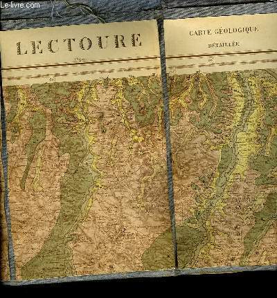
OFFICIERS DU CORPS D'ETAT MAJOR
LECTOURE 217 - CARTE TOPOGRAPHIQUE DE L'ETAT MAJOR - CARTE GEOLOGIE DETAILLEE
NON PRECISE. 1861. In-Plano. En feuillets. Bon état, Couv. convenable, Dos satisfaisant, Intérieur frais. 1 carte dépliante en couleurs entoilée grise. Echelle 1/80000. Dimensions : 112.5 x 61 cm.. . . . Classification Dewey : 912-Atlas, cartes et plans
书商的参考编号 : RO30041831
|
|
|
OFFICIERS DU CORPS D'ETAT MAJOR
MONTREAL 216 - CARTE TOPOGRAPHIQUE DE L'ETAT MAJOR - CARTE GEOLOGIQUE DETAILLEE
CH. BERANGER EDITEUR. 1858. In-Plano. En feuillets. Bon état, Couv. convenable, Dos satisfaisant, Intérieur frais. 1 carte dépliante entoilée en couleurs. Echelle : 1/80000. Dimensions : 117 x 63 cm.. . . . Classification Dewey : 912-Atlas, cartes et plans
书商的参考编号 : RO30041834
|
|
|
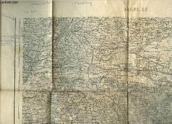
Officiers du Corps d'Etat-Major
Carte d'Etat-Major d'Angers S.O. - Type 1889 - 106
Dépôt de la Guerre. 1894. In-Plano. En feuillets. Etat d'usage, Couv. défraîchie, Dos satisfaisant, Papier jauni. Une carte en noir et blanc dépliante. 34 x 52 cm environ. Echelle : 1/80000. Annotations au crayon.. . . . Classification Dewey : 912-Atlas, cartes et plans
书商的参考编号 : RO80250503
|
|
|
OFFICIERS DU CORPS D'ETAT-MAJOR
Carte du Sud-Ouest de Périgueux
INSTITUT GEOGRAPHIQUE NATIONAL. 1955. In-Plano. En feuillets. Bon état, Livré sans Couverture, Dos satisfaisant, Intérieur frais. Carte dépliante en noir et blanc, de 53 x 74 cm. Echelle 1 / 50000. Un itinéraire tracé au feutre rose.. . . A l'italienne. Classification Dewey : 912-Atlas, cartes et plans
书商的参考编号 : RO80154199
|
|
|
OGER (F.)
Atlas de géographie générale, à l'usage des lycées, collèges et institutions préparatoires aux écoles du gouvernement, et de tous les établissements d'instruction publique.
Paris, Gauthier-Villars, 1875 In-folio, rel. de l'époque demi-toile noire, 2 ff.n.ch., 31 cartes lithographiées et aquarellées en 26 pl. à double page montées sur onglets.
书商的参考编号 : 525389
|
|
|
Oger (Félix)
Géographie générale, et géographie de la France physique, militaire, historique, politique, administrative et statistique.
français In-8 de VIII-249-5 pp.; demi-basane cerise, dos lisse orné (reliure de l'époque). Huitième édition. Petit accroc au dos. Sans atlas.
|
|
|
Ogrissek, Rudi
Haack Hausatlas
Gotha, Leipzig: VEB Hermann Haack, Geographisch-Kartographische Anstalt, 1974. 3., überarbeitete und erweiterte Auflage 296 Seiten , 35 cm Gewebeeinband in Einsteckhülle
书商的参考编号 : 19220

|
|
|
Ogueur (J.)
Carte touristique du Nord-Finistère.
français Sans date (circa 1930). Carte dépliante : 53x74 cm. Sous chemise de l'éditeur. Avec publicités locales au dos de la carte. Petit manque à l'angle supérieur du second plat.
|
|
|
Ohainski, Uwe. Reitemeier, Arnd
Das Fürstentum Braunschweig - Wolfenbüttel im Jahr 1574. Der Atlas des Gottlieb Mascop.
Bielefeld., Verlag für Regionalgeschichte., 2012. Herausgegeben von Uwe Ohainski und Arnd Reitemeier. 230 Seiten mit vielen Abbildungen (in Farbe und Schwarzweiß) im Text, 28 Tafelseiten im Anhang mit je einer Kommentar seiten, 7 weitere Kartenseiten im Anhang. Guter Zustand. Erschien vermutlich zur Ausstellung im Städtischen Museum Braunschweig: "Vermessen gannz furstenthumb Braunschweig. Der älteste Ämteratlas aus Niedersachsen". Quer - 2°. OPappband.
书商的参考编号 : 062249
|
|
|
OHIO / ATLAS / BIRD'S EYE VIEWS AND MAPS
Atlas of Athens Co. Ohio. From actual Surveys by and under the directions of D. J. Lake C.E. to which is added A Township Map of the State of Ohio. Cover title: Atlas of Athens Co. Ohio.
Philadelphia.: Titus Simmons & Titus. 1875. Large folding handcoloured map 23 3/4 x 23 1/2 inches folding handcolored street map Nelsonville full page hand coloured maps full page black and white lithographic illustrations 88pp 16 1/2 x 14 1/2 inches gilt lettered decorative embossed cloth covered boards hardbound. Wear to cover extremities exposing edges of boards head of spine split a few small abraded areas on back cover; interior has scattered foxing and soiled areas in margins occasional pencil mark creases and foxing to front endpaper overall toning / soiling to map of Carthage. Large folding map has 1 inch separation along one fold the extra large Nelsonville map which folds out has a short split at the centre of the lower fold being rather tricky to fold out from the atlas. Overall the atlas is in bright condition with tight binding. A fine example of an American county atlas testimony to a county with proud and industrious landowners and businesses. Among the interesting views are small interior vignettes of the interiors of Scott's Drug Store and Carnes & Shephard's Store in Nelsonville Ohio. This antique atlas includes an attractive large folding map: Railroad & Township Map of the State of Ohio with a decorative border and vignette illustration of the State Capitol at Columbus in the lower right corner plus a folding street map of Nelsonville. There are full page maps of Townships and Towns some with more than one map to a page. The bird's eye views of the local landscapes city views and portraits of important figures are particularly richly lithographed. . Titus, Simmons & Titus. hardcover
书商的参考编号 : 41248
|
|
|
ohne Agaben
CH Touring: Die Schweiz und Grenzgebiete - Automobilführer 1974/ 1975
Bern, Hallwag AG, 1974. 264, 271 Seiten , 24 cm, Hardcover/Pappeinband
书商的参考编号 : 50471

|
|
|
ohne Agaben
CH Touring: Die Schweiz und Grenzgebiete - Automobilführer 1966/ 1967
Bern, Hallwag AG, 1966. 246, 256 Seiten , 24 cm, Hardcover/Pappeinband
书商的参考编号 : 50321

|
|
|
ohne Angabe
Atlas der Weltwunder Faszinierende Bauwerke und Monumente - Vom Kolosseum zum Tadsch Mahd
Gütersloh: Bertelsmann Club GmbH, 1992. 240 Seiten , 30 cm, Pappeinband mit Schutzumschlag
书商的参考编号 : 7791

|
|
|
ohne Angabe , ohne Autor
Adelboden - Le
ohne Angabe. ca 1900 Postkartenheft mit 10 schwarzweiss Ansichten von Adelboden /
书商的参考编号 : 40411

|
|
|
ohne Angabe , ohne Autor
Album von Weimar. - Leporello
Jena, Verlag der Frommann'schen Hofbuchhandlung (Armin Bräunlich), o. J. (vor 1900) 1900. 20 Ansichten, s/w Photographien der Stadt in Leporello-Form, 10,5x13,5cm (Querformat)
书商的参考编号 : 40749

|
|
|
ohne Angabe , ohne Autor
Dresden - Leporello mit 20 Ansichten
Dresden, Römmler & Jonas 1894. 20 Fotografien (Lichtdrucke), 14,6 x 9,6 cm, roter Kaliko - Einband, Einband wasserfleckig, Leporello mit 20 Abb. montiert auf Karton, sonst Exemplar in gutem Erhaltungszustand
书商的参考编号 : 58636

|
|
|
ohne Angabe , ohne Autor
Frederiksborg Slot - 10 udvalgte Billeder
C. Rathsach, Hillerbrod Eneret ca. 1900. querformat: 22 x 12,5 cm Leporello mit 10 schwarzweiss Fotos, Exemplar in gutem Erhaltungszustand
书商的参考编号 : 40409

|
|
|
ohne Angabe , ohne Autor
Hildesheim : 20 der schönsten Ansichten in Postkartenform, in feinstem Kupfertiefdruck-Verfahren
Cassel : Kunstverlagsanstalt Bruno Hansmann. 20 monochrome Ansichtskarten, 14 x 9 cm Leporello im Kartonumschlag, Exemplar in gutem Erhaltungszustand
书商的参考编号 : 40419

|
|
|
ohne Angabe , ohne Autor
Leipzig 1813 - 1913 - Album - Leporello
Darmstadt, Zedler & Vogel ohne Jahr (1913). 1913. 20 Ansichten in schwarzweiss Leporello, Einband fleckig, sonst Exemplar in gutem Erhaltungszustand
书商的参考编号 : 40748

|
|
|
ohne Angabe , ohne Autor
Luftkurort Freudenstadt im Schwarzwald 730 m ü. M. mit Umgebung - Postkarten-Leporello
Tübingen, Sting. 10 Ansichtskarten im Kupfertiefdruck Leporello mit Postkarten, Exemplar in gutem Erhaltungszustand
书商的参考编号 : 40758

|
|
|
ohne Angaben
JRO Welt Atlas
München, JRO Kartografische Verlagsgesellschaft, 1987. 246 Seiten , 19 cm, Hardcover/Pappeinband
书商的参考编号 : 47846

|
|
|
OIZON René et alii
Atlas mondial.
Paris, Larousse, 1996. 24 x 32, 48 pp., très nombreuses cartes en couleurs, reliure d'édition pleine toile + jaquette, bon état.
书商的参考编号 : 39400 ???????? : 2035212081
|
|
|
Oldenhof, H
Lytse Schotanus Atlas
Fryske Akademy, Leeuwarden, 1967. 4°, quer, 143 S., zahlr. s/w Karten, , Because of nonsensical laws, orders outside of Germany will only be carried out if the delivery is made to an address in Germany! Lieferungen NUR an Adressen in Deutschland! Bezahlung per PayPal möglich, we accept PayPal, , Einb. min. beschabt u. min. bestoßen u. ger. angeschmutzt, Schnitte angeschmutzt, altersbed. Bräunungen, ger. Gebr.sp., Leinen
书商的参考编号 : 38086
|
|
|
OLIPHANT MARGARET
ATLAS DU MONDE ANTIQUE.
FRANCE LOISIRS / SOLAR. 1994. In-4. Relié. Bon état, Couv. convenable, Dos satisfaisant, Intérieur frais. 220 pages. Nombreuses illustrations en couleur et en noir et blanc dans le format hors texte.. . . . Classification Dewey : 912-Atlas, cartes et plans
书商的参考编号 : R240047347
|
|
|
OLIPHANT MARGARET
L'ATALS DU MONDE ANTIQUE
FRANCE LOISIRS. 1994. In-4. Cartonné. Bon état, Couv. convenable, Dos satisfaisant, Intérieur frais. 220 pages - nombreuses photos, illustrations et cartes en noir et blanc et en couleurs dans et hors texte.. . . . Classification Dewey : 912-Atlas, cartes et plans
书商的参考编号 : RO20176255
|
|
|
OLIPHANT MARGARET
L'ATLAS DU MONDE ANTIQUE.
FRANCE LOISIRS. 1993. In-4. Relié. Bon état, Couv. convenable, Dos satisfaisant, Intérieur frais. 220 pages - nombreuses illustrations, cartes en couleurs et en noir et blanc dans et hors texte - petite annotation sur la page de titre.. . . . Classification Dewey : 912-Atlas, cartes et plans
书商的参考编号 : R240138180
|
|
|
OLIPHANT, Margaret.
L'Atlas du Monde Antique.
Paris, France Loisirs, 1993. in-4 (25x31), 220 pp., illustrations N/B et en couleurs, index, cartonnage editeur illustre
书商的参考编号 : 19823
|
|
|
OLIPHANT, Margaret.
L'Atlas du Monde Antique.
in-4 (25x31), 220 pp., illustrations N/B et en couleurs, index, cartonnage editeur illustre Bel exemplaire [PIL-HA4]
|
|
|
OLIVIER CAMBESSEDES
ATLASECO DE POCHE. EDITION 1988. ATLAS ECONOMIQUE MONDIAL
EDITIONS S.G.B.. 1988. In-12. Cartonné. Bon état, Couv. convenable, Dos satisfaisant, Intérieur frais. 655 pages.. . . . Classification Dewey : 912-Atlas, cartes et plans
书商的参考编号 : RO20139172
|
|
|
OLIVIER CAMBESSEDES
ATLASECO DE POCHE. EDITION 1993. ATLAS ECONOMIQUE MONDIAL.
LES EDITIONS DU SERAIL. 1993. In-12. Cartonné. Etat d'usage, Couv. légèrement passée, Dos fané, Intérieur frais. 927 pages. Premier plat illustré en couleurs. Cartes en noir et gris dans le texte.. . . . Classification Dewey : 912-Atlas, cartes et plans
书商的参考编号 : R260134567
|
|
|
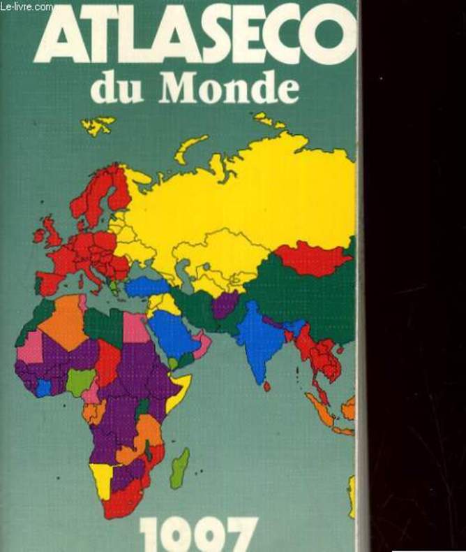
OLIVIER CAMBESSEDES
ATLASECO DU MONDE 1997
LES EDITIONS EOC. 1996. In-12. Broché. Bon état, Couv. convenable, Dos satisfaisant, Intérieur frais. 712 pages. Premier plat illustré en couleurs. Nombreuses cartes et tableaux.. . . . Classification Dewey : 912-Atlas, cartes et plans
书商的参考编号 : R260170672 ???????? : 290976608
|
|
|
OLIVIER CAMBESSEDES
ATLASECO DU MONDE. EDITION 1997
EOC. 1996. In-12. Broché. Bon état, Couv. convenable, Dos satisfaisant, Intérieur frais. 711 pages. Nombreuses cartes en noir et blanc, dans le texte. Tampons sur la page de tire et la tranche.. . . . Classification Dewey : 912-Atlas, cartes et plans
书商的参考编号 : RO20144952 ???????? : 290976608
|
|
|
OLLIVER Jane
Mon premier atlas.
NATHAN Fernand.. 1977. In-4. Cartonné. Bon état, Couv. convenable, Dos satisfaisant, Intérieur frais. 61 pages. Nombreuses cartes et illustrations en couleurs dans le texte et hors-texte.. . . . Classification Dewey : 912-Atlas, cartes et plans
书商的参考编号 : RO80015845 ???????? : 2092900153
|
|
|
ONESIME RECLUS
ATLAS PITTORESQUE DE LA FRANCE - EN 4 VOLUMES : TOMES I +II +III + IV - COMPLET.
SOCIETE DES ATLAS PITTORESQUES. 1909. In-4. Relié. Etat d'usage, Couv. convenable, Dos frotté, Intérieur frais. 399 + 399 + 399 + 399 pages illustrées de nomberuses photos et cartes en noir et blanc - 3e et 4eme plats marbrész - Coiffes en tete et pied abimées.. . . . Classification Dewey : 912-Atlas, cartes et plans
书商的参考编号 : R320028553
|
|
|
Oon, Helen
Singapur [Reiseführer & Reisekarte] / Übers. aus d. Engl.: Nicola Schwenkert.
Köln : Könemann, 1998. 128 S. + große Faltkt. zahlr. Ill., Kt. 8°. Dt., überarb. Ausg. Ill. OBroschur u. Kartenteil im OSchuber.
书商的参考编号 : 37320
|
|
|
Oral Cancer American Cancer Society Atlas of Clinical Oncology Sol Silverman Jr. Jr
Oral Cancer American Cancer Society Atlas of Clinical Oncology Sol Silverman
New. unknown
书商的参考编号 : BOOK_9781550092158 ???????? : 1550092154 9781550092158

|
|
|
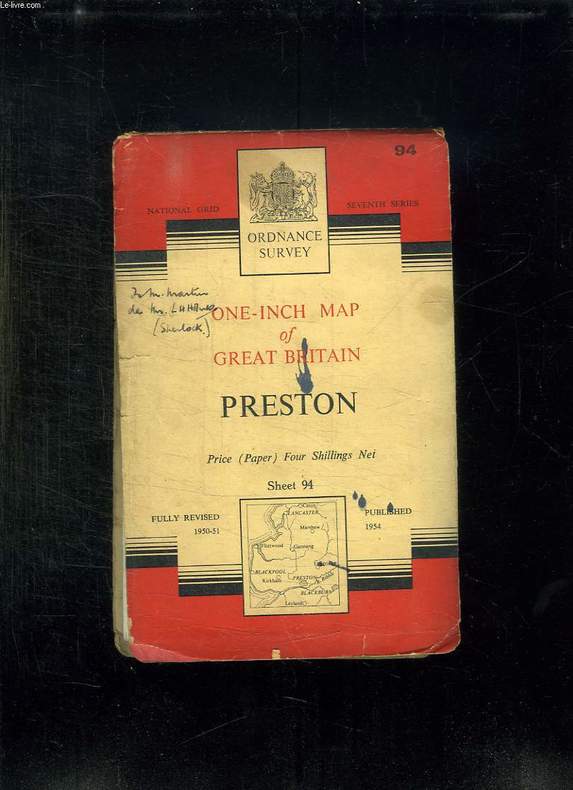
ORDNANCE SURVEY.
ONE INCH OF GREAT BRITAIN. PRESTON.
CHEZ L AUTEUR.. 1954. In-8. Broché. Bon état, Couv. légèrement passée, Dos satisfaisant, Pliures. Carte en couleurs dépliante. 84 cm / 69 cm. Note au stylo sur le premier plat de couverture, ainsi qu'une tache d'encre.. . . . Classification Dewey : 912-Atlas, cartes et plans
书商的参考编号 : R150160019
|
|
|
ORDNANCE SURVEY.
ONE INCH OF GREAT BRITAIN. PRESTON.
CHEZ L AUTEUR.. 1954. In-8 Carré. Broché. Bon état. Couv. légèrement passée. Dos satisfaisant. Pliures. Carte en couleurs dépliante. 84 cm / 69 cm. Note au stylo sur le premier plat de couverture, ainsi qu'une tache d'encre.

|
|
|
OREGON ATLAS. METSKER Charles Frederick.
Metsker’s atlas of Yamhill County State of Oregon.
Portland OR & Tacoma WA: Metsker the Map Man 1928. Oblong atlas folio. 18 x 14.5 in. 33 leaves cyanotype blueprints. Including 32 detailed blueprint plat maps dated Sept. 1928. Publisher’s flexible simulated calf post-binder gilt lettering title stamped on front cover burgundy-coloured silk more pastedowns neat typed label affixed to upper fore-edge of spine minor rubbing shelfwear some maps w/ pencil corrections & additions two maps loose and 1 w/ extensive coloured corrections manuscript additions additional other corrections still VG copy. First edition thus of this Yamhill County Metsker plat map atlas providing invaluable historical and genealogical data for Oregon towns and areas at the end of the 1920s in this now thriving wine-growing region. The cities include Grande Ronde Willamina Sheridan McMinnville Lafayette Carlton and Newberg. The index provides specific names and locations for Donation Land Claims Fruit Farms and Tracts as well as cities towns and suburban additions. Of interest are the names noted in the Grande Ronde town sited in this atlas on pp. 30 & 31 which was where a number of Grande Ronde Native Americans were allowed to leave the reservation and establish farms and ranches around the town site set up by International Harvester at the endo of the Willamina and Grande Ronde Railroad. Metsker 1881-1966 civil engineer and mapmaker began working as a teenager with his father in a Winlock WA sawmill by 1900 and later by 1910 ahd become a draftsman in an engineering office in Tacoma WA followed during the next 15 years by stints at engineering firms in Seattle Tacoma and Portland before striking out on his own as a mapmaker surveyor and mapmaker during the Roaring 20s. Metsker’s maps were sold by subscription and updated on an ongoing basis so the subscribers were supposed to throw out the earlier versions of the maps and replace them in the succeeding decades. They all received heavy use and the earliest versions created in the 1920s and 1930s are by far the scarcest of the atlases produced by the firm. Worldcat locates 5 copies of the 1930 State Library of Oregon OSU OHS. Metsker the Map Man, unknown
书商的参考编号 : 55695
|
|
|
OREGON ATLAS. METSKER Charles Frederick.
Metsker’s atlas of Lincoln County State of Oregon.
Portland OR & Tacoma WA: Metsker the Map Man 1937. Oblong atlas folio. 18 x 14.5 in. 38 leaves cyanotype blueprints. Including 37 detailed blueprint plat maps consistently dated 1930 1 large folding key map sized 19 x 16.5 in. Publisher’s flexible simulated calf post-binder gilt lettering title stamped on front cover burgundy-coloured silk more pastedowns remnants of typed spine label minor rubbing shelfwear some maps w/ pencil and pen corrections and additions 1 traced map NF copy. Second edition thus of this relatively rare Lincoln County Metsker plat map atlas providing invaluable historical and genealogical data for Oregon coastal towns and areas on the eve of the Great Depression including Gleneden Depoe Bay Newport Pacific View Waldport and Yachats. The index provides specific names and locations for Donation Land Claims Fruit Farms and Tracts including logging and sawmill tracts such as the Siuslaw National Forest as well as cities towns and suburban additions. Metsker 1881-1966 civil engineer and mapmaker began working as a teenager with his father in a Winlock WA sawmill by 1900 and later by 1910 ahd become a draftsman in an engineering office in Tacoma WA followed during the next 15 years by stints at engineering firms in Seattle Tacoma and Portland before striking out on his own as a mapmaker surveyor and mapmaker during the Roaring 20s. Metsker’s maps were sold by subscription and updated on an ongoing basis so the subscribers were supposed to throw out the earlier versions of the maps and replace them in the succeeding decades. They all received heavy use and the earliest versions created in the 1920s and 1930s are by far the scarcest of the atlases produced by the firm. Worldcat locates 3 copies of the 1930 Multnomah County Library State Library of Oregon OSU. Metsker the Map Man, unknown
书商的参考编号 : 55693
|
|
|
OREGON ATLAS. METSKER Charles Frederick.
Metsker’s atlas of Marion County State of Oregon.
Portland OR & Tacoma WA: Metsker the Map Man 1929. Oblong atlas folio. 18 x 14.5 in. 45 leaves cyanotype blueprints. Including 44 detailed blueprint plat maps consistently dated 1929 1 large folding key map sized 24.5 x 14.25 in. Publisher’s flexible simulated calf post-binder gilt lettering title stamped on front cover burgundy-coloured silk more pastedowns neat typed label affixed to upper fore-edge of spine minor rubbing shelfwear NF copy. First edition thus of this exceedingly scarce Marion County Metsker plat map atlas providing invaluable historical and genealogical data for 1920s Salem Turner Silverton Stayton and as far north as the area around Aurora Oregon. The index provides specific names and locations for Donation Land Claims Fruit Farms and Tracts including logging and sawmill tracts as well as cities towns and suburban additions. Metsker 1881-1966 civil engineer and mapmaker began working as a teenager with his father in a Winlock WA sawmill by 1900 and later by 1910 ahd become a draftsman in an engineering office in Tacoma WA followed during the next 15 years by stints at engineering firms in Seattle Tacoma and Portland before striking out on his own as a mapmaker surveyor and mapmaker during the Roaring 20s. Metsker’s maps were sold by subscription and updated on an ongoing basis so the subscribers were supposed to throw out the earlier versions of the maps and replace them in the succeeding decades. They all received heavy use and the earliest versions created in the 1920s and 1930s are by far the scarcest of the atlases produced by the firm. Worldcat locates 3 copies of the 1929 Multnomah County Library OHS State Library of Oregon. Metsker the Map Man, unknown
书商的参考编号 : 55692
|
|
|
OREGON ATLAS. METSKER Charles Frederick.
Metsker’s atlas of Benton County State of Oregon.
Portland OR & Tacoma WA: Metsker the Map Man 1929. Oblong atlas folio. 18 x 14.5 in. 25 leaves cyanotype blueprints. Including 24 detailed blueprint plat maps consistently dated 1929. Publisher’s flexible simulated calf post-binder gilt lettering title stamped on front cover burgundy-coloured silk more pastedowns neat typed label affixed to upper fore-edge of spine minor rubbing shelfwear some maps w/ pencil corrections & additions NF copy. First edition thus of this Benton County Metsker plat map atlas providing invaluable historical and genealogical data for Oregon towns and areas at the end of the 1920s including Albany Philomath Corvallis Monroe Alpine and more. The index provides specific names and locations for Donation Land Claims Fruit Farms and Tracts including Imperial Walnut Orchards Anderson Colony Orchards and OACO Orchards as well as cities towns and suburban additions. Metsker 1881-1966 civil engineer and mapmaker began working as a teenager with his father in a Winlock WA sawmill by 1900 and later by 1910 ahd become a draftsman in an engineering office in Tacoma WA followed during the next 15 years by stints at engineering firms in Seattle Tacoma and Portland before striking out on his own as a mapmaker surveyor and mapmaker during the Roaring 20s. Metsker’s maps were sold by subscription and updated on an ongoing basis so the subscribers were supposed to throw out the earlier versions of the maps and replace them in the succeeding decades. They all received heavy use and the earliest versions created in the 1920s and 1930s are by far the scarcest of the atlases produced by the firm. Worldcat locates 5 copies of the 1930 Multnomah County Library State Library of Oregon OSU OHS Yale. Metsker the Map Man, unknown
书商的参考编号 : 55694
|
|
|
ORIENTAL PHILATELIC HOUSE.
[MAP] Map of Cairo, Egypt. Most interesting places in Cairo [and] Egyptian stamps guide.
Very Good English This rare blue-toned lithographed city map showing Nile shores on the south, Tombs of the Khalifs on the north, Railway Central Station on the west. It's folded in its publisher's wrappers. "Most interesting places in Cairo" list on the right side of the paper, up to the Oriental Philatelic House address and advertisement. On verso of the map, Oriental Philatelic House's illustrated collectible postage stamps list including completely Middle Eastern stamps like Egypt, Congress, and Commemorative Stams, Egyptian Sudanese stamps, Arabia-Hedjaz (Cradle and Home of Mohammedanism), Nejd (Wahhabi Regime), Palestine, Iraq, Packets, Transjordan, Great Libanon, and Syria. Original city map of Cairo in original publisher's wrappers. Cr. 8vo. (19 x 11 cm). In English. Oblong folio. (As open: 37 x 52 cm).
|
|
|
ORIEUX Jean
KASBAHS EN PLEIN CIEL. DANS LE HAUT ATLAS MAROCAIN.
1951 Flammarion 1951, In-8 broché, 182 pages, couverture à rabats. Exemplaire numéroté sur Alfa , no 424 sur 3025 , important envoi autographe. Bel état
书商的参考编号 : 5108
|
|
|
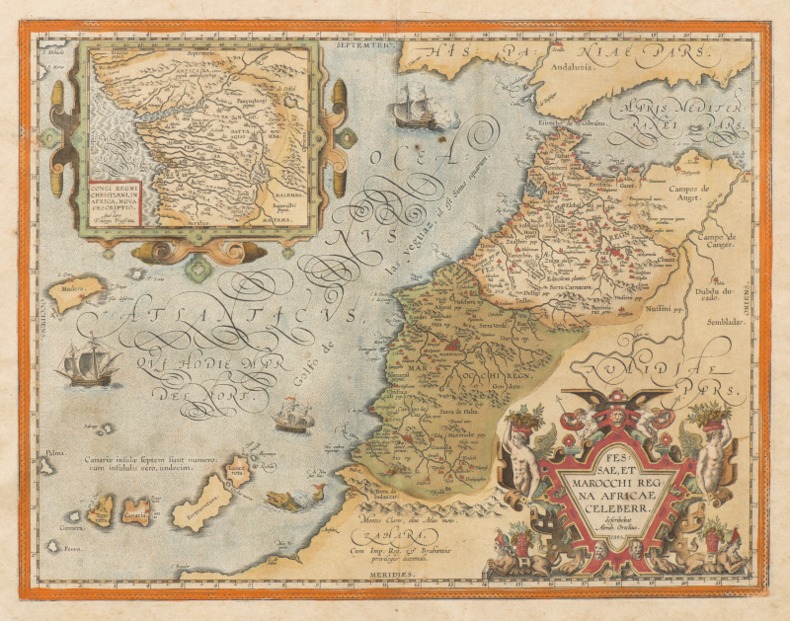
ORTELIUS (Abraham).
FESSAE, ET MAROCCHI REGNA AFRICAE CELEBERR. [Et] BARBARIAE ET BILEDULGERID, nova descriptio. [2 cartes XVIe du MAROC].
1595 [Anvers], Ortelius, 1595. Deux cartes (51 X 39 cm) et (50 X 33 cm) sous cadres en pichepin.
书商的参考编号 : 004429
|
|
|
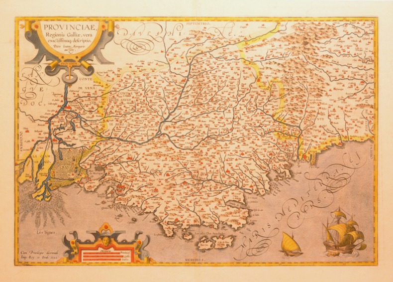
ORTELIUS (Abraham).
PROVINCIAE, REGIONIS GALLIAE, VERA EXACTISSIMAQ DESCRIPTIO. Petro Ioanne Bompario auctore. PROVENCE.
1595 [Anvers], Ortelius, 1594. Carte (557 X 405 mm, marges comprises) sous cadre en bois noirci moderne.
书商的参考编号 : 004430
|
|
|
ORTELIUS, Abraham
Theatro del mondo. L'atlas de poche d'Ortelius
L’Atlas de poche d’Ortelius en italien, complet de ses 108 cartes à pleine page, conservé dans sa reliure de l’époque. Venetia, Per Scipion Banca, 1667. In-16 de (4) ff., 232 pp., (8) ff. 108 cartes gravées à pleine page. Relié en vélin rigide de l’époque. Ex libris manuscrit sur le faux titre : « Bibliotheca Neorelli ». 133 x 93 mm.
书商的参考编号 : LCS-1863

|
|
|
Ortelius, Abraham
Theatrum orbis terrarum. REPRINT der Ausgabe zu Nuermberg durch Johann Koler anno MDLXXII [1572]. Mit einer Einf. und Erl. von Ute Schneider.
Darmstadt, Wissenschaftliche Buchgesellschaft WBG, 2006. 208 S., meist farb. Karten. 40,5 cm. Goldgeprägt. OLn mit mont. farb. Deckelillustration.
书商的参考编号 : 99067

|
|
 ?????????
 ?????PDF???
 RSS feed


