|
PELTIER G.
Les Provinces Baltiques de la Russie.
L'ILLUSTRATION. 18 septembre 1915. In-Plano. En feuillets. Bon état, Livré sans Couverture, Dos satisfaisant, Intérieur frais. Carte dépliante en noir et blanc de 40 / 59 cm. . . . Classification Dewey : 912-Atlas, cartes et plans
Bookseller reference : RO80072044
|
|
|
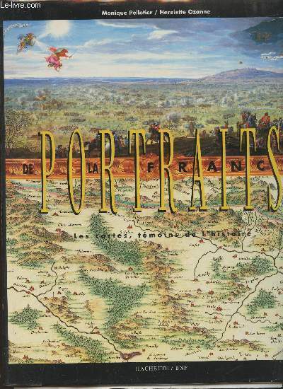
Pelletier Monique, Ozanne Henriette
Portraits de la France- Les cartes, témoins de l'histoire
Hachette/Bibliothèque nationale de France. 1995. In-4. Relié. Bon état, Couv. convenable, Dos satisfaisant, Intérieur acceptable. 259 pages. Jaquette correcte. Rares rousseurs. Nombreuses cartes en couleurs, in et hors texte.. Avec Jaquette. . . Classification Dewey : 912-Atlas, cartes et plans
Bookseller reference : RO30351968 ISBN : 2012351514
|
|
|
Pelletier (Monique) - Ozanne (Henriette)
Portraits de la France. Les cartes, temoins de l’histoire.
Hachette 1995 In-4 pleine toile éditeur. Jaquette en très bon état. Occasion comme neuf. Poids sans emballage : 1420 grammes.
Bookseller reference : 23607 ISBN : 2012351514
|
|
|
PELOUZE J. et FREMY E.
Traité de CHIMIE générale comprenant les applications de cette science à l'analyse chimique, à l'industrie, à l'agriculture et à l'histoire naturelle. ATLAS seul.
1855 Paris, Masson 1855. Deuxième édition. Grand in 8° de 32 pp. et 53 plaches gravées doubles; belle reliure en demi-chagrin à 5 nerfs , avec le nom des auteurs, le titre de l'ouvrage et la mention ATLAS finement dorés, caissons ornés de triples filets dorés. Rousseurs.
Bookseller reference : 1797
|
|
|
Pelletier (Jean), Virlogeux (Jean)
Géographie classes de première.
français In-8 de 430-(2) pp. + carte h.t.; cartonné éditeur. Collection Max Derruau.
|
|
|
PELTIER G.
CARTE DE L YSER A L AISNE. 1/ 420000. FRONT DU 1 JANVIER 1976. SUPPLEMENT A L ILLUSTRATION.
CHEZ L AUTEUR.. Non daté. In-Folio Carré. Broché. Bon état. Couv. légèrement passée. Dos satisfaisant. Pliures. Carte en couleurs de 58.5 cm / 40.5cm.

|
|
|
PENGUIN HISTORICAL ATLAS OF ANCIENT CIVILIZATIONS THE.
By J. HAYWOOD.
Ldn. etc. Penguin Books 2005. 144 p. ills. maps. Stiff wrs. 25 cm unknown
Bookseller reference : 113051
|
|
|
Penn Arthurand Jacob Atlas r. an
"A Conversation with Arthur Penn" in Rolling Stone No. 54 March 18 1970
San Francisco: Straight Arrow 1970. Near fine in original wrappers. Complete issue. First Edition. Soft Cover. Near Fine. Straight Arrow Paperback
Bookseller reference : b40826
|
|
|
Penning, Lars (Red.), Astrid Arnold und Kathrin Eger u.a
Haack Weltatlas. Klausuren (Mit CD-ROM).
Stuttgart : Klett, 2010. 250 S. (29,5 cm) Paperback / kartonierte Ausgabe
Bookseller reference : 50305
|
|
|
PERIGOT CH.
ATLAS COMPLEMENTAIRE DU DICTIONNAIRE DE BIOGRAPHIE ET D'HISTOIRE DE GEOGRAPHIE ANCIENNE ET MODERNE DE MM. CH. DEZOBRY ET TH. BACHELET - 35 CARTES COULEURS.
DELAGRAVE CH. ET CIE. 1866. In-4. Relié demi-cuir. Etat d'usage, Couv. convenable, Dos satisfaisant, Intérieur frais. 35 cartes en couleurs dont certaines depliantes - contre-plats jaspés - Dos à 4 nerfs - Auteur, titres et filets dorés - 1 etiquette collée en coiffe en pied.. . . . Classification Dewey : 912-Atlas, cartes et plans
Bookseller reference : R320058033
|
|
|
Perpillou, Collectif
Atlas Blondel 1947.
Blondel la Rougery. 1947. In-12. Cartonné. Etat d'usage, Coins frottés, Dos satisfaisant, Papier jauni. 32 pages, nombreuses cartes en couleur hors texte - tranches frottées, annotations à l'encre sur le 1er contreplat et la 1re page.. . . . Classification Dewey : 912-Atlas, cartes et plans
Bookseller reference : R200128017

|
|
|
PERTHES, Justus
Atlas Antiquus. Taschenatlas der Alten Welt. Bearbeitet von Dr. Alb. van KampenZenthe Auflage
Gotha, Justus Perthes 1900 In-16 17 x 10 cm. Reliure éditeur demi-toile marron, titre en bistre sur le dos et le premier plat de couverture, 60 pp., 24 cartes en double page, index.
Bookseller reference : 135303

|
|
|
Pervillé Guy
Atlas de la guerre d'Algérie : De la conquête à l'indépendance
Editions Autrement Atlas/Mémoires Dos carré collé 2003 In-8 (17,1 x 24,5 cm), dos carré collé, 63 pages, iconographie et cartes en couleur ; très bon état général. Livraison a domicile (La Poste) ou en Mondial Relay sur simple demande.
Bookseller reference : qg2283
|
|
|
PERROT A:
Atlas portatif de France contenant les 86 cartes des 86 départemens et la carte générale de France, dessinées par A. Perrot, et gravées sur acier par P. Tardieu publié par la Société Nationale pour l'émancipation intellectuelle.
Paris, aux bureaux du Journal des Connaissances utiles, 1833. In-12 carré, 88 cartes, demi-veau brun, dos lisse, pièce de titre verte. Papier légèrement bruni. Noms de possesseuses (!): Adèle Perrochers sur la p. de titre, et Ida Jaccard-Roessinger, 1871 sur la p. de garde. Il manque la page de titre.
Bookseller reference : 6286
|
|
|
PERRET A.
CARTE ENTOILEE : L'ARRONDISSEMENT DE MAULEON D'APRES LES PLANS DU CADASTRES ET AUTRES DOCUMENTS / DEPARTEMENT DES BASSES PYRENEES / DIMENSION : 1 m 75 Cm ENVIRON.
PERRET A.. 1853. In-Plano. En feuillets. Etat d'usage, Couv. défraîchie, Dos satisfaisant, Intérieur acceptable. Carte toilée illustrée en noir et blanc et couleurs - LEGENDE -. . . . Classification Dewey : 912-Atlas, cartes et plans
Bookseller reference : R320038250
|
|
|
PERTHES Justus
Carte de l'Empire d'Allemagne.
- 1 carte 30 x 23 cm, pliée en deux.
Bookseller reference : 84465
|
|
|
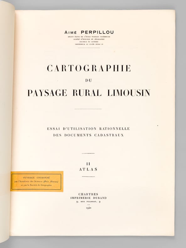
PERPILLOU, Aimé
Cartographie du Paysage Rural Limousin. Essai d'utilisation rationnelle des documents cadastraux. II : Atlas
1 vol. in-folio br., Imprimerie Durand, Chartres, 1940, 3 ff., 21 planches
Bookseller reference : 64502
|
|
|
PERROT AM - ARAGON Alex
Dictionnaire universel de géographie moderne. Texte + atlas
Delloye Houdaille Paris, Delloye Houdaille, 1834. 2 tomes reliés en 1 volume in-4 pleine basane de l'époque. Dos lisse à faux nerfs dorés, fleurons dorés, pièce de titre maroquin rouge. Coins légèrement émoussés. Faux titre, titre, 508 + 563 pages. Accompagné d'un atlas de 60 cartes coloriées gravées par Pierre TARDIEU, dont une dépliante. Ou description physique, politique et historique de toutes les contrées et de tous les lieux remarquables de la terre. BEL EXEMPLAIRE. Texte sur 2 colonnes.
Bookseller reference : 19668
|
|
|
PERROT (A. M.) - ARAGON (Mme Alex.).-
Dictionnaire Universel de géographie moderne, description physique, politique et historique de tous les lieux de la terre accompagné d'un atlas de 59 cartes coloriées. Nouvelle édition.
P., Bureau Central des Dictionnaires, 1837, 2 tomes reliés en 1 volume demi basane fauve, dos lisse orné, 508 et 563 pages ; mors fendu sur 5 cm ; frottis d'usage ; quelques rousseurs éparses.
Bookseller reference : 63670
|
|
|
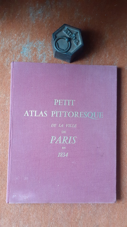
PERROT A.-M.
Petit Atlas pittoresque des quarante-huit quartiers de la Ville de Paris par A.-M. Perrot, ingénieur (1834)
Editions de Minuit, in-4 rel. toile bordeaux (25,5 x 32,5), 49 p.+26 fnch, non daté (c. 1960), reproduction en fac-similé avec une introduction, des notes des additions et des corrections par Michel Fleury et Jeanne Pronteau, 2 plans pleine page, 48 planches chacune accompagnée d'une vignette, bon état.
Bookseller reference : QWA-20509
|
|
|
PERROT, A.-M.
Petit Atlas Pittoresque des quarante-huit Quartiers de la Ville de Paris [ Edition originale ]
1 vol. in-4 cartonnage éditeur avec restauration en simili demi-maroquin à coins vert, Chez E. Garnot, Paris, 1834, 3 ff., XVIII pp. et 48 planches doubles en couleurs
Bookseller reference : 65921

|
|
|
PERRIER Edmond Oscar Schneider
Principaux types des êtres vivants des cinq parties du Monde .Atlas.
In 4 demi-toile rouge à coins,titre doré sur le premier plat,suite de XV planches sur double page,très nombreuses figures en noir.édition originale Jouvet & Cie 1882
Bookseller reference : 1675
|
|
|
PEREIRA ANTHONY
ROME - CARNET DE VOYAGEURS
GALLIMARD. 1985. In-12. Cartonnage d'éditeurs. Bon état, Couv. convenable, Dos satisfaisant, Intérieur frais. 224 pages illustrées de quelques cartes en couleur en fin d'ouvrage. Jacquette en couleur conservée.. Avec Jaquette. . . Classification Dewey : 912-Atlas, cartes et plans
Bookseller reference : RO30017477 ISBN : 2070703940
|
|
|
Percy Bysshe Shelley
Shelley's Poetry and Prose: Authoritative Texts, Criticism (Norton Critical Edition)
Book shows light wear to covers only. Text/interior is clean and unmarked in any way. 700 pages with authoritative texts and criticism. Very inclusive.

|
|
|
Pereña-García, Mercedes
Atlas Iberoamericano.
Mexico, Secretariía de Relaciones Exteriores, 1991. 31 x 30 cm, 103 Seiten, mit zahlreichen Karten, weinrotes Leinen, Original-Schutzumschlag. Primera edición leichte Gebrauchsspuren, private Widmung auf fliegendem Blatt, gute Erhaltung.
Bookseller reference : 28825AB
|
|
|
Perforating Guns Atlas Corporation and Gulf Oil Corporation.
Gulf Oil Corporation Hayes Lumber Company Inc. et al # 1 Well Hayes Field Jefferson Davis Parish Louisiana. Perforating Guns Atlas Corporation Electrical Log SP and Resistivity.
Perforating Guns Atlas Corporation. 1958. Print. Good. No Binding. Folded Well Log / Electrical Log SP and Resistivity; Depth Reached = 11009'; Feet Measured = 7000'; light browning of well log; several notations/markings in pencil/colored pencil; o/w in good condition. Perforating Guns Atlas Corporation. unknown
Bookseller reference : 024614
|
|
|
Perforating Guns Atlas Corporation.
Gulf Refining Company A. Atkinson B-1 Well Hayes Field Jefferson Davis Parish Louisiana. Perforating Guns Atlas Corporation Electrical Log.
Perforating Guns Atlas Corporation. 1956. Print. Good. No Binding. Folded Well Log / Electrical Log; Top Logged Interval = 2512'; Bottom Logged Interval = 12102'; light browning of log; several intervals marked in colored pencil w/ minor notations; o/w in good condition. Perforating Guns Atlas Corporation. unknown
Bookseller reference : 026579
|
|
|
Perpillou (A.), Pernet (L.)
Géographie 5e. Le Monde moins l'Europe et l'U.R.S.S.
français Dédicacé par l'auteur In-8 de 223 pp.; cartonné de l'éditeur. Riche illustration. Envoi autographe signé de Perpillou, en marge du titre. Petits transferts de scotch dans les gardes.
|
|
|
Perrey, Werner
Sternbilder. Himmelsatlas für das ganze Jahr
Stuttgart: Verlag Urachhaus, 2003. 120 S. ; 26,5 x 31,5 cm quer ;Pp. ;
Bookseller reference : 126322

|
|
|
Perrin
Plan de St Pétersbourg. Gravé par Mce Perrin. Echelle 1/52000.
français Sans date (circa fin XIXe siècle). 16x23 cm [22,5x31 cm]. Gravé par Mce Perrin. Echelle 1/52000.
|
|
|
Perrot A. M. From 'Atlas Portatif du Royaume de France...'
HAUTE MARNE Area - City of Chaumont - an Original Hand-Coloured Antique Engraved Map
Paris: Unknown. Near Fine with no dust jacket. 1823. Unknown - Possibly 1st. Map. One of Aristide Michel Perrots' charming and decorative French departement maps / cartes Fran�aises departemental. An original hand-coloured antique engraving no date shown but printed circa 1823 and set in an elaborate carouche in which Perrot displays the produce and crafts etc of the area. Hand-colouring is contemporary and later. In a plain brown mount and ready to frame. Cartographer is A. M. Perrot and engraved by Blanchard. A most attractive and decorative engraving of a map of the Haute Marne Area - featuring the City of Chaumont including Wassy Langres etc France. Some pale spotting to the blank margins and overall an Excellent deep and very clean image. See Image. ; 24mo 5" - 6" tall . Unknown unknown
Bookseller reference : 114918

|
|
|
Perrot A. M. From 'Atlas Portatif du Royaume de France...'
HAUTES ALPES Area - City of Briancon - an Original Hand-Coloured Antique Engraved Map
Paris: Unknown. Near Fine with no dust jacket. 1823. Unknown - Possibly 1st. Map. One of Aristide Michel Perrots' charming and decorative French departement maps / cartes Fran�aises departemental. An original hand-coloured antique engraving no date shown but printed circa 1823 and set in an elaborate carouche in which Perrot displays the produce and crafts etc of the area. Hand-colouring is contemporary and later. In a plain brown mount and ready to frame. Cartographer is A. M. Perrot and engraved by Blanchard. A most attractive and decorative engraving of a map of the Hautes ALPES Area - featuring the City of Briancon including Embrun GAP etc. Some pale spotting to the blank margins but pretty negligible and overall an Excellent deep and very clean image. See Image. ; 24mo 5" - 6" tall . Unknown unknown
Bookseller reference : 114916

|
|
|
Perrot A. M. From 'Atlas Portatif du Royaume de France...'
MEURTHE Area - City of Nancy - an Original Hand-Coloured Antique Engraved Map
Paris: Unknown. Near Fine with no dust jacket. 1823. Unknown - Possibly 1st. Map. One of Aristide Michel Perrots' charming and decorative French departement maps / cartes Fran�aises departemental. An original hand-coloured antique engraving no date shown but printed circa 1823 and set in an elaborate carouche in which Perrot displays the produce and crafts etc of the area. Hand-colouring is contemporary and later. In a plain brown mount and ready to frame. Cartographer is A. M. Perrot and engraved by Blanchard. A most attractive and decorative engraving of a map of the Meurthe Area - featuring the City of Nancy including Luneville Sarrebourg etc France. Some pale spotting to the blank margins but overall an Excellent deep and very clean image. See Image. ; 24mo 5" - 6" tall . Unknown unknown
Bookseller reference : 114920

|
|
|
Perrot A. M. From 'Atlas Portatif du Royaume de France...'
Oise Area - City of Beauvais - An Original Hand-Coloured Antique Engraved Map
Paris: Unknown. Near Fine with no dust jacket. 1823. Unknown - Possibly 1st. Map. One of Aristide Michel Perrots' charming and decorative French departement maps / cartes Fran�aises departemental. An original hand-coloured antique engraving no date shown but printed circa 1823 and set in an elaborate carouche in which Perrot displays the produce and crafts etc of the area. Hand-colouring is contemporary and later. In a plain brown mount and ready to frame. Cartographer is A. M. Perrot and engraved by Blanchard. A most attractive and decorative engraving of a map of the Oise Area - featuring the City of Beauvais including Clermont Compiegne etc. Some VERY pale spotting to the blank margins but negligible hardly seen and overall an Excellent deep and very clean image. See Image. ; 24mo 5" - 6" tall . Unknown unknown
Bookseller reference : 114914

|
|
|
Perrot A. M. From 'Atlas Portatif du Royaume de France...'
Vienne Area - City of Poitiers - an Original Hand-Coloured Antique Engraved Map
Paris: Unknown. Near Fine with no dust jacket. 1823. Unknown - Possibly 1st. Map. One of Aristide Michel Perrots' charming and decorative French departement maps / cartes Fran�aises departemental. An original hand-coloured antique engraving no date shown but printed circa 1823 and set in an elaborate carouche in which Perrot displays the produce and crafts etc of the area. Hand-colouring is contemporary and later. In a plain brown mount and ready to frame. Cartographer is A. M. Perrot and engraved by Blanchard. A most attractive and decorative engraving of a map of the Vienne Area - featuring the City of Poitiers including Chatellerault Montmorillon etc. Some VERY pale spotting to the blank margins but negligible hardly seen and overall an Excellent deep and very clean image. See Image. ; 24mo 5" - 6" tall . Unknown unknown
Bookseller reference : 114915

|
|
|
Perrot A. M. From 'Atlas Portatif du Royaume de France...'
VOSGES Area - City of Epinal - an Original Hand-Coloured Antique Engraved Map
Paris: Unknown. Near Fine with no dust jacket. 1823. Unknown - Possibly 1st. Map. One of Aristide Michel Perrots' charming and decorative French departement maps / cartes Fran�aises departemental. An original hand-coloured antique engraving no date shown but printed circa 1823 and set in an elaborate carouche in which Perrot displays the produce and crafts etc of the area. Hand-colouring is contemporary and later. In a plain brown mount and ready to frame. Cartographer is A. M. Perrot and engraved by Blanchard. A most attractive and decorative engraving of a map of the Vosges Area - featuring the City of Epinal including Marecourt Neufchateau etc France. Some pale spotting to the blank margins but overall an Excellent deep and very clean image. See Image. ; 24mo 5" - 6" tall . Unknown unknown
Bookseller reference : 114919

|
|
|
PERROT AM - ARAGON Alex
Dictionnaire universel de géographie moderne. Texte + atlas
Paris, Delloye Houdaille, 1834. 2 tomes reliés en 1 volume in-4 pleine basane de l'époque. Dos lisse à faux nerfs dorés, fleurons dorés, pièce de titre maroquin rouge. Coins légèrement émoussés. Faux titre, titre, 508 + 563 pages. Accompagné d'un atlas de 60 cartes coloriées gravées par Pierre TARDIEU, dont une dépliante. Ou description physique, politique et historique de toutes les contrées et de tous les lieux remarquables de la terre. BEL EXEMPLAIRE. Texte sur 2 colonnes.

|
|
|
PERROT, Aristide Michel - THIERRY
Atlas géographique et topographique des Départemens de la France, composé de quatre-vingt sept cartes, dessinées par A. Perrot, et gravées par Thierry.
In-8° (23x15 cm); front., 1 grande carta geogr. Più volte ripiegata posta all’inizio del volume dopo il frontespizio, 28 + 24 + 34 tavv. di carte geografiche numerate, con confini acquerellati a mano. Legatura in cartoncino moderno molle con titolo in nero impresso al dorso. Prima edizione di questo celebre atlante della Francia. Restauro rinforzo al recto del frontespizio e per il resto le carte si presentano in ottime condizioni di conservazione e con ampi margini. L’opera presenta tutto il territorio francese così come uscì dall’epoca napoleonica e dalla restaurazione. Le tavole, molto belle, presentano un bella coloritura coeva. Il volume è opera di Aristide Michel Perrot che fu uno dei cartografi più celebri del suo tempo. L’ultima carta è una bella mappa della Corsica. Tutte le tavole portano una data compresa tra il 1824 ed il 1825. Le carte sono opera di Thierry. L’opera, qui probabilmente in prima edizione, ebbe poi varie riedizioni con numero di carte differenti. Qui sono presenti la grande carta della Francia e tutte le carte dei distretti. Si trovano esemplari, ma probabilmente in edizioni susseguenti, con una carta di Parigi e di alcune colonie francesi. Esemplare raro e a parte il restauro al frontespizio in buone condizioni di conservazione.
|
|
|
PERTHES, Justus
Taschenatlas der ganzen Welt
Gotha, Justus Perthes, 1941. 75. Auflage 8°. 110 S., 1 Bl. Mit 44 doppelblattgrossen Karten. 18 x 11 cm, Halbleinen ohne Schutzumschlag
Bookseller reference : 7196
|
|
|
Perthes, Justus
Taschenatlas von Deutschland.
Gotha, Perthes, 1950. 14., völlig neubearb. Aufl. 8° 40 Kart. m. Namenverzeichn. Hlw. Sauber u. gut erhalten. 14
Bookseller reference : 52110AB
|
|
|
Pertusier Charles author Piringer Benedikt engraver Pertusier Charles. Atlas des promenades pittoresques dans Constantin
Promenades pittoresques dans Constantinople et sur les rives du Bosphore suivies d'une notice sur la Dalmatie 1815 Hardcover
2020. Hardcover. New. Lang: - fre Pages 85. Reprinted in 2020 with the help of original edition published long back 1815. This book is Printed in black & white Hardcover sewing binding for longer life with Matt laminated multi-Colour Dust Cover Printed on high quality Paper re-sized as per Current standards professionally processed without changing its contents. As these are old books we processed each page manually and make them readable but in some cases some pages which are blur or missing or black spots. If it is multi volume set then it is only single volume if you wish to order a specific or all the volumes you may contact us. We expect that you will understand our compulsion in these books. We found this book important for the readers who want to know more about our old treasure so we brought it back to the shelves. Any type of Customisation is possible with extra charges. Hope you will like it and give your comments and suggestions. hardcover
Bookseller reference : 1111015862661
|
|
|
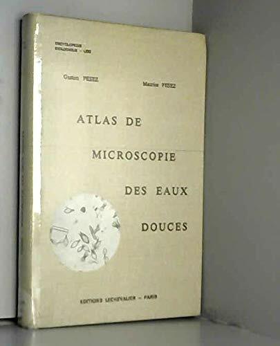
Pesez (Maurice) ; Pesez (Gaston)
Atlas de microscopie des eaux douces
Lechevalier, coll. « Encyclopédie biologique LXXI » 1977 In-8 relié pleine toile, avec 101 plaches, 24,5 cm sur 16,5. 285 pages. Très bon état d’occasion.
Bookseller reference : 135154
|
|
|
Peter C.J. van der Krogt
Advertenties voor kaarten, atlassen, globes e.d. in Amsterdamse kranten, 1621-1811.,
Antwerpen/Utrecht , De Vries/HES , 1985 Gebonden, 473pp. ISBN 978906194055590.
Bookseller reference : 30900
|
|
|
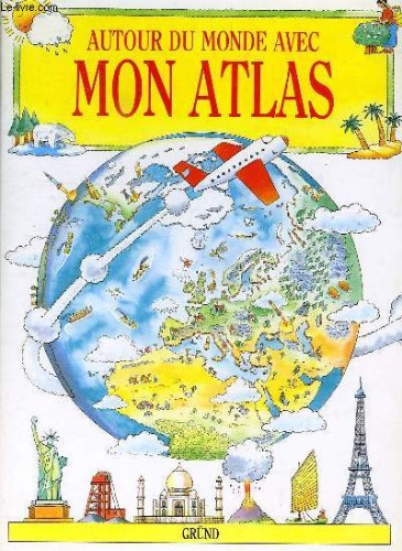
PETTY KATE, KING COLIN
AUTOUR DU MONDE AVEC MON ATLAS
Gründ. 1991. In-4. Relié. Bon état, Couv. convenable, Dos satisfaisant, Intérieur frais. 32 pages. Illustré de nombreux dessins en couleur.. . . . Classification Dewey : 912-Atlas, cartes et plans
Bookseller reference : RO40152224
|
|
|
PETIT J. / ROUABLE M.
CROQUIS ET TRAVAUX PRATIQUE- CYCLE D OBSERVATION- L ENSEIGNEMENT DE LA GEOGRAPHIE- CLASSE DE 5ème
FERNAND NATHAN. 1954. In-8. Broché. Etat d'usage, Plats abîmés, Dos satisfaisant, Intérieur frais. POCHETTE CONTENANT 21 CROQUIS (11 MANQUANTS). . . . Classification Dewey : 912-Atlas, cartes et plans
Bookseller reference : R200046433
|
|
|
PETIT (Paul).
Précis d'histoire ancienne.
PUF, 1965 in-8° carré, 351 pp, 2e édition revue, 21 cartes dépliantes hors texte, biblio, cart. illustré de l'éditeur, bon état
Bookseller reference : 108609

|
|
|
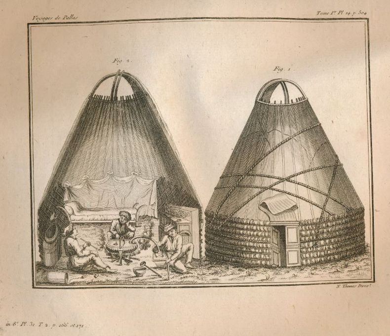
Peter Simon PALLAS
Voyage du Professeur Pallas dans plusieurs provinces de l'Empire de Russie, et de l'Asie septentrionale. Atlas
Maradan A Paris, chez Maradan An II. 1794. Atlas in-Folio relié sous couverture d'attente cartonnée de l'époque. Le papier est manquant en dos de la reliure. Traduit de l'Allemand par le Cit. Gauthier de la Peyronie. Nouvelle édition revue et enrichie de notes par les C C. Lamarck, Professeur de géologie au Muséum National d'Histoire Naturelle ; Langlès, Sous-Garde des manuscrits de la Bibliothèque Nationale, pour les langues Arabe, Persane, Tatane-Mantchoue, & Billecocq, Homme de lettres. Contenant la Carte générale de l'Empire de Russie, d'après la nouvelle division de cet Empire en quarante-deux gouvernemens ; dix Cartes Géographiques ; soixante-dix-sept planches de botanique ; douze autres représentant des fourneaux, moulins, monumens & ; onze d'idoles et costumes ; et onze d'animaux, d'Histoire naturelle, d'Hiéroglyphes, &. Atlas bien complet des 108 planches dont douze dépliantes. Celles-ci sont toutes montées sur onglets et classées selon la disposition de l'édition in-8. Déchirure sans manque au bas de la planche 33 - 33 bis, sans manque.
Bookseller reference : 124716
|
|
|
Peter Elck; Ron Atlas
Looking for Zebra
Little Simon 1986. Hardcover. Good. Disclaimer:A copy that has been read but remains in clean condition. All pages are intact and the cover is intact. The spine may show signs of wear. Pages can include limited notes and highlighting and the copy can include previous owner inscriptions. The dust jacket is missing. At ThriftBooks our motto is: Read More Spend Less. Little Simon hardcover
Bookseller reference : G0671629239I3N01 ISBN : 0671629239 9780671629236

|
|
|
Peter Elck; Ron Atlas
Looking for Zebra
Little Simon 1986. Hardcover. Good. Disclaimer:A copy that has been read but remains in clean condition. All pages are intact and the cover is intact. The spine may show signs of wear. Pages can include limited notes and highlighting and the copy can include previous owner inscriptions. At ThriftBooks our motto is: Read More Spend Less.Dust jacket quality is not guaranteed. Little Simon hardcover
Bookseller reference : G0671629239I3N00 ISBN : 0671629239 9780671629236

|
|
|
Peter Elck; Ron Atlas
Looking for Zebra
Little Simon 1986. Hardcover. Acceptable. Disclaimer:A readable copy. All pages are intact and the cover is intact. Pages can include considerable notes-in pen or highlighter-but the notes cannot obscure the text. At ThriftBooks our motto is: Read More Spend Less.Dust jacket quality is not guaranteed. Little Simon hardcover
Bookseller reference : G0671629239I5N00 ISBN : 0671629239 9780671629236

|
|
 Receive by email
 Download as PDF document
 RSS feed


