|
SERRYN PIERRE, CAUET RENE, VINCENT MARC
PETIT ATLAS GENERAL
Bordas. Non daté. In-4. Relié. Etat passable, Plats abîmés, Dos abîmé, Papier jauni. 48 pages et index. Illustré de cartes en couleur. Dos maintenu par du ruban adhésif. Plats se détachant, maintenus par du scotch jauni.. . . . Classification Dewey : 912-Atlas, cartes et plans
Bookseller reference : RO60023008
|
|
|
SERRYN PIERRE, CAUET RENE, VINCENT MARC
PETITE ATLAS GENERAL
Bordas. 1956. In-4. Relié. Etat d'usage, Couv. défraîchie, Dos abîmé, Intérieur bon état. 48 pages et index. Illustré de cartes en couleur. Dos et plats se détachant.. . . . Classification Dewey : 912-Atlas, cartes et plans
Bookseller reference : RO60023009
|
|
|
SERET G.
ATLAS GEOGRAPHIQUE
ISBN : 2871272603. Erasme - Le Grand Livre du Mois. 1993. In-4 Carré. Relié. Bon état. Couv. convenable. Dos satisfaisant. Intérieur frais. 120 pages. Illustré de nombreuses cartes en couleur. Grand In-4°. Etiquette de code sur le dos. Annotations en page de titre. Le monde. Géologie. Climat. Economie. Tourisme...

|
|
|
SERET G., SWYSEN L.
ATLAS GEOGRAPHIQUE
ISBN : 287127049X. Erasme - Le Grand Livre du Mois. 1986. In-4 Carré. Relié. Très bon état. Couv. fraîche. Dos impeccable. Intérieur frais. 120 pages. Illustré de nombreuses cartes en couleur. Grand In-4°.

|
|
|
SERRYN P., BLASSELLE R., BONNET M.
NOUVEL ATLAS GENERAL, LA FRANCE, L'UNION FRANCAISE, LE MONDE
Bordas - Librairies Joseph Gibert. 1954. In-4 Carré. Relié. Etat d'usage. Coins frottés. Dos fané. Intérieur acceptable. 144 pages. Illustré de nombreuses cartes en couleur. Couverture légèrement passée, avec bord du 2e plat légèrement abîmé. 'Collection d'ouvrages géographiques', dir. par Henri Bordas.

|
|
|
SERRYN P., BLASSELLE R., BONNET M., CAUET R.
E.G.P., LE MONDE ET SON VISAGE, 4 VOLUMES
Bordas. 1961. In-4 Carré. Relié. Bon état. Couv. convenable. Dos satisfaisant. Intérieur frais. 4 volumes illustrés de nombreuses photos en noir et blanc et en couleur hors texte, de cartes et schémas en noir et bleu dans et hors texte, et de cartes en couleur hors texte. Encyclopédie Géographique Permanente. Tome I: Le monde et son visage. Tome II: Atlas géographique, Atlas historique. Tome III: 5 dossiers économiques (Démographie, Agriculture, Energie, Industrie, Transport et commerce). Volume IV: Les grandes enquêtes (n° 1, 2, 3, 4, 6, 8, 9, 10, 11).

|
|
|
SERRYN P., BLASSELLE R., BONNET M., CAUET R.
LE MONDE ET SON VISAGE, 2 TOMES
Bordas. 1956. In-4 Carré. Relié, Sous emboîtage. Bon état. Couv. convenable. Dos satisfaisant. Intérieur frais. 256 + 144 pages pour le tome I + env. 250 pages (fiches volantes) dans le tome II. Illustrés de nombreuses photos en noir et blanc et en couleur hors texte, de cartes et schémas en noir et bleu dans et hors texte, et de cartes en couleur hors texte. Encyclopédie géographique permanente. Atlas et fiches Commerce, Transports, Industrie, Agriculture, Pêche et Energie.

|
|
|
SERRYN PIERRE.
GRAND ATLAS UNIVERSEL.
ISBN : 2040103120. BORDAS.. 1978. In-4 Carré. Relié plein cuir. Bon état. Couv. convenable. Dos satisfaisant. Intérieur frais. 216 + 177 pages. Nombreuse cartes en couleurs hors texte.

|
|
|
Serv. Topogr. F?d?ral
Atlas Topographique de la Suisse: Martigny-Combin report sur pierre
1 74x91 cm., formato aperto, 28 riquadrisu 4 file, a colori, applicati su tela, formato chiuso 18,5x13 , scala 1:50.000, con frontespizio, in francese, buone condizioni.
|
|
|
Service G?ographique de l'Arm?e
Nice - Menton
1 56,5x79,5 formato aperto, pi? volte ripiegata, chiusa cm.,20x14, a colori, su carta speciale, scala 1:200.000. Aggiunta carta su carta e tela di Menton, buone condizioni.
|
|
|
SERVICE GEOGRAPHIQUE DE L ARMEE.
CARTE DE BOURG ST MAURICE 1/ 50000.
CHEZ L AUTEUR.. Non daté. In-Plano Carré. Broché. Bon état. Couv. légèrement passée. Dos satisfaisant. Pliures. Carte en couleurs de 56cm / 69 cm. Tampon dans la marge de la carte.

|
|
|
Service geographique de l'Arm?e
Avignon
1 51x74 cm., formato aperto, 17x10,5 formato chiuso, in 21 riquadri su tre file su carta a colori applicati su tela, scala 1.200.000, in francese, buone condizioni
|
|
|
SERVICE GEOGRAPHIQUE DU LEVANT.
[MAP of SYRIA and LEBANON] Map of Syria and Lebanon. Scale: 1:1.100.000.
Very Good English Original color map folded in its papers. Very good. Folded. Atlas folio. (60 x 47 cm). In English. [MAP of FRENCH MANDATE SYRIA and LEBANON] Map of Syria and Lebanon. Scale: 1:1.100.000. No date.
|
|
|
Seutter
ATLAS
Atlas monté au XIXème siècle de cartes du XVIIIème siècle en majorité coloriées.35 dans un livre de format in-8 demi-relié.2 Mappemondes.2 cartes de l'Europe.Allemagne.Autriche.Bohème. Silésie.Pologne.Poméranie. Russie. Cartes de Seutter. Vaugondy.Bon état dans l'ensemble.
Bookseller reference : 49761
|
|
|
SEVIN-TALIVE ; FOURNIER ; LATERRADE ; CREPIN
Atlas cantonal du département de Lot-et-Garonne (28 cartes dépliantes) [ Contient : ] Arrondissement d'Agen (7 cartes : Canton d'Agen - Canton d'Astaffort - Canton de Puymirol - Canton de Beauville - Canton de Laplume - Canton de Laroque-Timbaut - Canton de Prayssas) - Arrondissement de Villeneuve-sur-Lot (10 Cartes : Canton de Castillonnès - Canton de Sainte-Livrade - Canton de Villeneuve - Canton de Villeréal - Canton de Penne - Canton de Fumel - Canton de Tournon - Canton de Monclar - Canton de Monflanquin - Canton de Cancon) - Arrondissement de Marmande (8 Cartes : Canton de Bouglon - Canton de Meilhan - Canton de Castelmoron - Canton de Seyches - Canton de Lauzun - Canton de Marmande - Canton de Duras - Canton de Mas-d'Agenais) - Arrondissement de Nérac (3 cartes : Canton de Casteljaloux - Canton de Francescas - Canton de Houeilliès)
Atlas cantonal du département de Lot-et-Garonne, 28 cartes dépliantes entoilées conservées par arrondissement sous étuis cartonnés, Imp. Lemercier et Cie, Paris, (pour la deuxième édition) échelle de 1 millimètre pour 30 mètres, 1/30.000. [ Détail : ] Arrondissement d'Agen (7 cartes : Canton d'Agen, Carte dressée sur les plans d'assemblage du Cadastre pour le service des chemins vicinaux par M. Sevin-Talive, Troisième édition, corrigée et mise à jour sous l'Administration de M. A. Henry, Officier de la Légion d'Honneur, Préfet du Département, par M. Laterrade, Ingénieur-Voyer en chef, 1882 - Canton d'Astaffort, Carte dressée sur les plans d'assemblage du Cadastre pour le service des chemins vicinaux par M. Sevin-Talive, deuxième édition, corrigée et mise à jour sous l'Administration de M. A. Henry, Officier de la Légion d'Honneur, Préfet du Département, par M. Laterrade, Ingénieur-Voyer en chef, 1881 - Canton de Puymirol, troisième édition, corrigée et mise à jour sous l'Administration de M. Bès-de-Berc, Officier de la Légion d'Honneur, Préfet du Département, par M. A. Crépin, Ingénieur-Voyer en chef, 1888 - Canton de Beauville, deuxième édition, 1882 - Canton de Laplume, Troisième édition, Chapront et Fournier, 1886 - Canton de Laroque-Timbaut, Troisième édition Bès-de-Berg et Crépin, 1888 - Canton de Prayssas, Troisième édition, Chapront et Fournier, 1886) - Arrondissement de Villeneuve-sur-Lot (10 Cartes : Canton de Castillonnès : Carte dressée sur les plans d'assemblage du Cadastre pour le service des chemins vicinaux par M. Sevin-Talive, deuxième édition, corrigée et mise à jour sous l'Administration de M. A. Henry, Officier de la Légion d'Honneur, Préfet du Département, par M. Laterrade, Ingénieur-Voyer en chef, 1882 - Canton de Sainte-Livrade, idem, 1881 - Canton de Villeneuve, troisième édition, corrigée et mise à jour sous l'Administration de M. A. Chapront, Officier de la Légion d'Honneur, Préfet du Département, par M. Fournier, Ingénieur-Voyer en chef, 1886 - Canton de Villeréal, deuxième édition, corrigée et mise à jour sous l'Administration de M. A. Henry, Officier de la Légion d'Honneur, Préfet du Département, par M. Laterrade, Ingénieur-Voyer en chef, 1882 - Canton de Penne, troisième édition, corrigée et mise à jour sous l'Administration de M. Bès-de-Berc, Officier de la Légion d'Honneur, Préfet du Département, par M. A. Crépin, Ingénieur-Voyer en chef, 1888 - Canton de Fumel, deuxième édition, corrigée et mise à jour sous l'Administration de M. A. Henry, Officier de la Légion d'Honneur, Préfet du Département, par M. Laterrade, Ingénieur-Voyer en chef, 1882 - Canton de Tournon, idem, 1882 - Canton de Monclar, deuxième édition, corrigée et mise à jour sous l'Administration de M. A. Henry, Officier de la Légion d'Honneur, Préfet du Département, par M. Laterrade, Ingénieur-Voyer en chef, 1882 - Canton de Monflanquin, troisième édition, corrigée et mise à jour sous l'Administration de M. Bès-de-Berc, Officier de la Légion d'Honneur, Préfet du Département, par M. A. Crépin, Ingénieur-Voyer en chef, 1888 - Canton de Cancon, idem, 1882) - Arrondissement de Marmande (8 Cartes : Canton de Bouglon, troisième édition, corrigée et mise à jour sous l'Administration de M. Bès-de-Berc, Officier de la Légion d'Honneur, Préfet du Département, par M. A. Crépin, Ingénieur-Voyer en chef, 1888 - Canton de Meilhan, idem, 1888 - Canton de Castelmoron, idem, 1888 - Canton de Seyches, Troisième édition, 1888 - Canton de Lauzun, Deuxième édition, 1882 - Canton de Marmande, Troisième édition, Chapront et Fournier, 1886 - Canton de Duras, Deuxième édition , 1882 - Canton de Mas-d'Agenais, idem, 1888) - Arrondissement de Nérac (3 cartes : Canton de Casteljaloux, Deuxième édition, Henry et Laterrade, 1882 - Canton de Francescas, Deuxième édition, Henry et Laterrade, 1881 - Canton de Houeilliès, Deuxième édition, Henry et Laterrade, 1882)
Bookseller reference : 65136
|
|
|
SEYIR VE HIHDROGRAFI DAIRESI.
Türk deniz haritalari ile ilgili denizcilere ilanlar (Haritalarin yayin tarihinden 1 Subat 1967 tarihine kadar), 1963-1967.
Very Good Turkish Paperback. Roy. 8vo. (24 x 17 cm). In Turkish. 40 p. Türk deniz haritalari ile ilgili denizcilere ilanlar (Haritalarin yayin tarihinden 1 Subat 1967 tarihine kadar), 1963-1967.
|
|
|
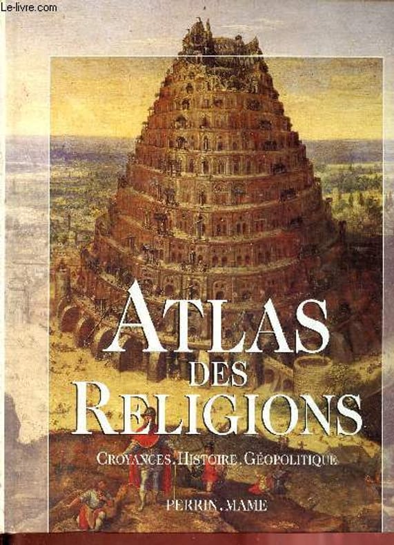
Sfeir Antoine
Atlas des religions - Croyances, histoire, géopolitique.
Perrin Mame. 1999. In-4. Relié. Bon état, Couv. convenable, Dos satisfaisant, Intérieur frais. 192 pages - nombreuses cartes et photos en couleurs dans le texte.. . . . Classification Dewey : 912-Atlas, cartes et plans
Bookseller reference : RO80276323
|
|
|
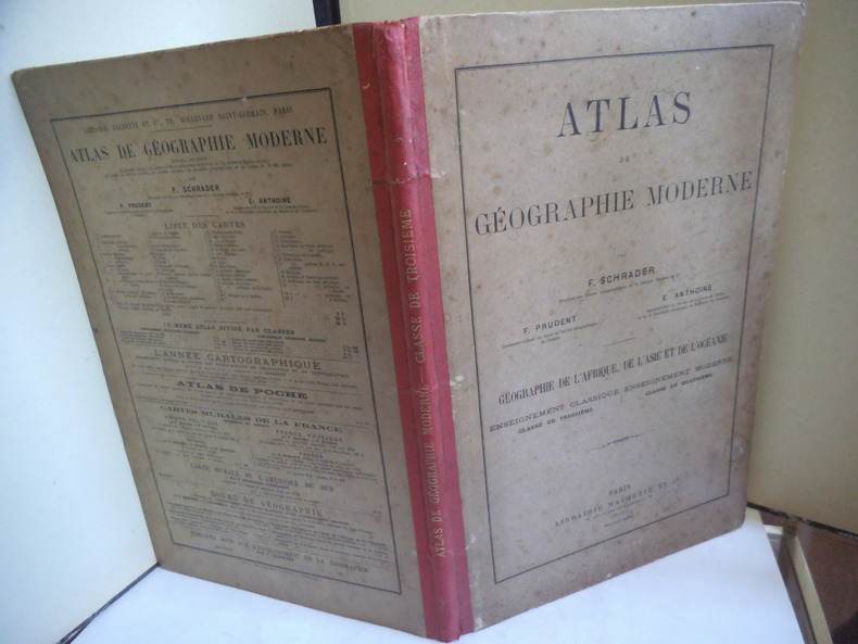
SHARDER F. PRUDENT F. E. ANTHOINE
Atlas de géographie moderne.
SHARDER F. PRUDENT F. E. ANTHOINE Atlas de géographie moderne. Géographie de l’Afrique, de l’Asie, et de l’Océanie. Petit in folio demie- toile rouge, avec titre doré, en long. Faux-titre, titre, 19 cartes en couleurs sur double page. Texte sur 2 colonnes avec cartes en noir. L’ensemble monté sur onglets. Paris Librairie HACHETTE 1895. Bon exemplaire. Asie- Russie- Arménie, Caucase-Asie Mineure- Perse- Hindoustan- Indo-Chine- Empire Chinois- Japon- Chine orientale-Océanie, Australie.
Bookseller reference : 12922
|
|
|
Shamlian, Frederick A
Knaurs Weltatlas.
München : Droemer Knaur, 2002. 312 S. : Ill., graph. Darst., zahlr. Kt., 37 cm. Gewebe, gebundene Ausgabe, SU.
Bookseller reference : 239018

|
|
|
Shapiro Harvey; Atlas James Contributor
Selected Poems Wesleyan Poetry Series
Wesleyan 1997-08-15. Paperback. Like New. bn1-e-34 Wesleyan paperback
Bookseller reference : 161102002 ISBN : 081952252X 9780819522528
|
|
|
SHELL
CARTE REGIONALE REGION PARISIENNE - LA FRANCE EN 10 CARTES N°3
FOLDEX. Non daté. In-Plano. Broché. Etat d'usage, Couv. légèrement passée, Dos satisfaisant, Intérieur acceptable. Carte dépliante en 10 volets, en couleurs au 1/400.000e.. . . . Classification Dewey : 912-Atlas, cartes et plans
Bookseller reference : RO70122339
|
|
|
SHELL
CARTE REGIONALE DE LA BRETAGNE - LA FRANCE DETAILLEE EN 10 CARTES
FOLDEX. Non daté. In-Plano. Broché. Etat d'usage, Couv. légèrement passée, Dos satisfaisant, Intérieur acceptable. Carte dépliante en 10 volets, en couleurs au 1/400.000e.. . . . Classification Dewey : 912-Atlas, cartes et plans
Bookseller reference : RO70122304
|
|
|
SHELL
CARTE REGIONALE TOURISTIQUE DE LA BRETAGNE XI
FOLDEX. Non daté. In-Plano. Broché. Etat d'usage, Couv. légèrement passée, Dos satisfaisant, Intérieur acceptable. Carte dépliante en 22 volets, en couleurs au 1/250.000e.. . . . Classification Dewey : 912-Atlas, cartes et plans
Bookseller reference : RO70122306
|
|
|
SHELL
CARTE ROUTIERE DE LA FRANCE
FOLDEX. 1988. In-Plano. Broché. Etat d'usage, Couv. légèrement passée, Dos satisfaisant, Intérieur acceptable. Carte dépliante en 24 volets, en couleurs au 1/1.000.000e.. . . . Classification Dewey : 912-Atlas, cartes et plans
Bookseller reference : RO70122308
|
|
|
SHELL
Carte Régionale N°10 : Côte d'Azur.
FOLDEX. Non daté. In-12. En feuillets. Bon état, Couv. convenable, Dos satisfaisant, Intérieur frais. Carte dépliante en couleurs, en 2 parties. 86 x 70 cm.. . . . Classification Dewey : 912-Atlas, cartes et plans
Bookseller reference : RO80091757
|
|
|
SHELL
Cartoguide Shell Berre N°12 : Pyrénées Côte Basque
CHEZ L'AUTEUR. 1959. In-12. En feuillets. Bon état, Couv. convenable, Dos satisfaisant, Intérieur frais. 1 carte dépliante en couleurs, de 46 x 58 cm. 1ère de couverture illustrée en couleurs par Jean Colin.. . . . Classification Dewey : 912-Atlas, cartes et plans
Bookseller reference : RO80091794
|
|
|
SHELL
CARTOGUIDE IRANSEN & SHELL SENEGAL
SHELL BERRE. 1978. In-Plano. Broché. Etat d'usage, Couv. légèrement passée, Dos satisfaisant, Intérieur acceptable. Carte dépliante en 10 volets, en couleurs. Note au stylo sur le 1er plat.. . . . Classification Dewey : 912-Atlas, cartes et plans
Bookseller reference : RO70122335
|
|
|
SHELL
CARTE DE LA FRANCE - ALLIANCES METS ET VINS N°3
IGN. Non daté. In-Plano. Broché. Etat d'usage, Couv. légèrement passée, Dos satisfaisant, Intérieur acceptable. Carte dépliante en 22 volets, en couleurs.. . . . Classification Dewey : 912-Atlas, cartes et plans
Bookseller reference : RO70122310
|
|
|
SHELL
CARTOGUIDE EUROPEEN SHELL TOURING
SHELL BERRE. Non daté. In-Plano. Broché. Etat d'usage, Couv. légèrement passée, Dos satisfaisant, Intérieur acceptable. Carte dépliante en 10 volets, en couleurs.. . . . Classification Dewey : 912-Atlas, cartes et plans
Bookseller reference : RO70122330
|
|
|
SHELL
DEUTSCHLAND
SHELL BERRE. 1958. In-Plano. Broché. Etat d'usage, Couv. légèrement passée, Dos satisfaisant, Intérieur acceptable. Carte dépliante en 12 volets, en couleurs au 1/1.500.000e. Note au stylo sur le 1er plat.. . . . Classification Dewey : 912-Atlas, cartes et plans
Bookseller reference : RO70122314
|
|
|
SHELL
EUROPE EUROPA
Chez l'auteur. non daté. In-Plano. En feuillets. Etat d'usage, Couv. convenable, Dos satisfaisant, Quelques rousseurs. Carte routière de l'Europe, au dos de la carte les différents points des stations service Shell en Europe, échelle au 1/5.000.000.. . . . Classification Dewey : 912-Atlas, cartes et plans
Bookseller reference : RO30009823
|
|
|
SHELL
FRANCE
SHELL BERRE. 1959. In-Plano. Broché. Etat d'usage, Couv. légèrement passée, Dos satisfaisant, Intérieur acceptable. Carte dépliante en 12 volets, en couleurs au 1/1.500.000e.. . . . Classification Dewey : 912-Atlas, cartes et plans
Bookseller reference : RO70122312
|
|
|
SHELL
FREIZEITKARTE OSTERREICH
FOLDEX. Non daté. In-Plano. Broché. Etat d'usage, Couv. légèrement passée, Dos satisfaisant, Intérieur acceptable. Carte dépliante en 32 volets, en couleurs au 1/500.000e.. . . . Classification Dewey : 912-Atlas, cartes et plans
Bookseller reference : RO70122305
|
|
|
SHELL
GREAT BRITAIN AND IRELAND
SHELL BERRE. Non daté. In-Plano. Broché. Etat d'usage, Couv. légèrement passée, Dos satisfaisant, Intérieur acceptable. Carte dépliante en 12 volets, en couleurs au 1/1.250.000e. Note au stylo sur le 2ème plat.. . . . Classification Dewey : 912-Atlas, cartes et plans
Bookseller reference : RO70122317
|
|
|
SHELL
ITALIA
SHELL BERRE. Non daté. In-Plano. Broché. Etat d'usage, Couv. légèrement passée, Dos satisfaisant, Intérieur acceptable. Carte dépliante en 12 volets, en couleurs au 1/1.250.000e.. . . . Classification Dewey : 912-Atlas, cartes et plans
Bookseller reference : RO70122318
|
|
|
SHELL
MAPA DAS ESTRADAS DE PORTUGAL
FOLDEX. Non daté. In-Plano. Broché. Etat d'usage, Couv. légèrement passée, Dos satisfaisant, Intérieur acceptable. Carte dépliante en 10 volets, en couleurs au 1/700.000e.. . . . Classification Dewey : 912-Atlas, cartes et plans
Bookseller reference : RO70122340
|
|
|
SHELL
MAP OF METROPOLITAN AREA NEW YORK CITY AND LONG ISLAND
SHELL BERRE. Non daté. In-Plano. Broché. Etat d'usage, Couv. légèrement passée, Dos satisfaisant, Intérieur acceptable. Carte dépliante en 18 volets, en couleurs.. . . . Classification Dewey : 912-Atlas, cartes et plans
Bookseller reference : RO70122337
|
|
|
SHELL
NEDERLAND
SHELL BERRE. 1958. In-Plano. Broché. Etat d'usage, Couv. légèrement passée, Dos satisfaisant, Intérieur acceptable. Carte dépliante en 8 volets, en couleurs au 1/600.000e.. . . . Classification Dewey : 912-Atlas, cartes et plans
Bookseller reference : RO70122319
|
|
|
SHERRER C.
Niederlande - Belgien und Luxembourg. Carte N° 40, extraite de Stielers Hand-Atlas.
- Carte 40 x 50 cm, pliée en 2.
Bookseller reference : 70145
|
|
|
SHERRER C. - HABENICHT H.
Ostalpen. (Alpenländer : Westlisches Blatt.) Carte N° 15, extraite de Stielers Hand-Atlas.
- Carte 40 x 50 cm, pliée en 2.
Bookseller reference : 70139
|
|
|
SHELL
PARIS - 2 CARTES GRANDES DE BANLIEUE PORTE DE PARIS RECTO VERSO
SHELL BERRE. 1961. In-Plano. Broché. Etat d'usage, Couv. légèrement passée, Dos satisfaisant, Intérieur acceptable. Carte dépliante en 18 volets, en couleurs au 1/100.000e.. . . . Classification Dewey : 912-Atlas, cartes et plans
Bookseller reference : RO70122332
|
|
|
SHELL
SCHWEIZ SUISSE
SHELL BERRE. 1958. In-Plano. Broché. Etat d'usage, Couv. légèrement passée, Dos satisfaisant, Intérieur acceptable. Carte dépliante en 12 volets, en couleurs au 1/550.000e.. . . . Classification Dewey : 912-Atlas, cartes et plans
Bookseller reference : RO70122320
|
|
|
SHERRER C. - HABENICHT H.
Schweiz. (Alpenländer : Westlisches Blatt) Carte N° 14, extraite de Stielers Hand-Atlas.
- Carte 40 x 50 cm, pliée en 2.
Bookseller reference : 70138
|
|
|
SHELL
STREET GUIDE AND MAP OF MONTREAL AND VICINITY
SHELL BERRE. Non daté. In-Plano. Broché. Etat d'usage, Couv. légèrement passée, Dos satisfaisant, Intérieur acceptable. Carte dépliante en 30 volets, en couleurs. Note au stylo sur le second plat.. . . . Classification Dewey : 912-Atlas, cartes et plans
Bookseller reference : RO70122338
|
|
|
SHERRER C. - KOFFMAHN O.
Thüringishe Staaten. Carte N° 13, extraite de Stielers Hand-Atlas.
- Carte 40 x 50 cm, pliée en 2.
Bookseller reference : 70137
|
|
|
Shell
Cartoguide Shell Berre-France 1969/70.
français Ensemble de 13 cartes des régions de France (manque la carte 12 des Pyrénées Côte Basque), du plan de Paris, des spécialités souvenirs et de la carte des grandes routes et des routes parallèles ; sous chemise plastique de l'éditeur. Illustrations en couleurs de D. Hamot.
|
|
|
Shell
Cartoguide Shell France 1968/69.
français Lot de 4 cartes des régions de France : 2. Bretagne. 3. Normandie. 6. Val de Loire. 8. Bourgogne Rhônes Alpes. Illustrations en couleurs de Alain Cornic.
|
|
|
Shepherd, William R
ATLAS OF MEDIEVAL AND MODERN HISTORY
Discoloration to boards. Former institution stamp on fly-page. One map is torn in half but still present. Binding is still tight. ; 80 maps
|
|
|
Shirley CARPENTER et Jean-Claude BOYER
ATLAS du MONDE en RELIEF
Un ouvrage de 205 pages, format 210 x 305 mm, illustré, relié cartonnage couleurs, publié en 1968, Tallandier, bon état
Bookseller reference : LFA-126743061
|
|
|
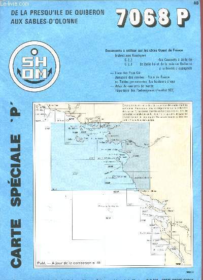
SHOM
1 Carte de la Presqu'île de Quiveron aux Sables d'Olonne - 7068P - Carte Spéciale 'P' - Echelle 1 : 150000
Etablissement Principal du Service Hydrographique et Océanographique de la Marine. Non daté. In-Plano. Broché. Très bon état, Couv. convenable, Dos satisfaisant, Intérieur frais. 1 carte dépliante en couleurs en trés bon état. Dimension :1099.8+748.6 mm.. . . . Classification Dewey : 912-Atlas, cartes et plans
Bookseller reference : R200107938
|
|
 Receive by email
 Download as PDF document
 RSS feed


