|
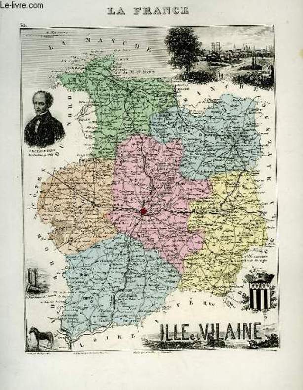
VUILLEMIN A., gravé par DYONNET Ch. - VILLEREY
1 carte gravée en couleurs de l'Ille-et-Vilaine - N°34
IMP. MIGEON. XIXe siècle. In-4. En feuillets. Bon état, Livré sans Couverture, Dos satisfaisant, Intérieur acceptable. Une planche ( de 34.5 x 26.5 cm) illustrée d'une carte en couleurs et de quelques gravures en noir et blanc.. . . . Classification Dewey : 912-Atlas, cartes et plans
书商的参考编号 : RO80091070
|
|
|
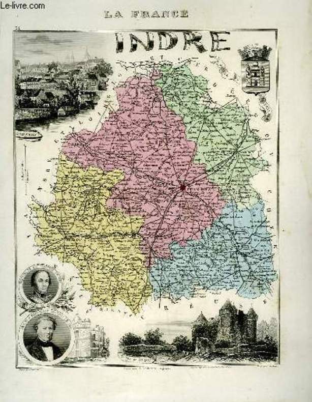
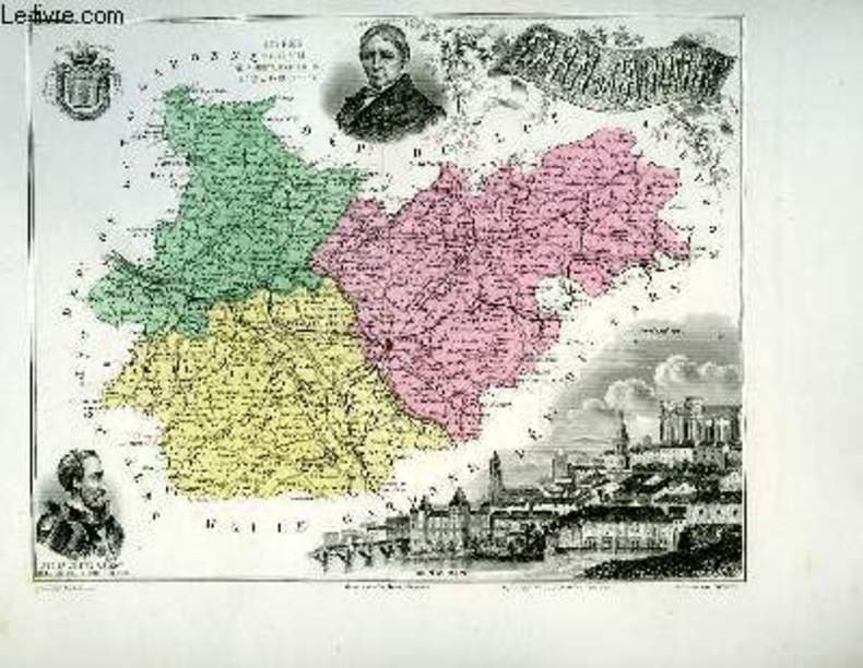
VUILLEMIN A., gravé par LEGENISEL - ISIDORE
1 carte gravée en couleurs de l'Indre - N°35
IMP. MIGEON. XIXe siècle. In-4. En feuillets. Bon état, Livré sans Couverture, Dos satisfaisant, Intérieur acceptable. Une planche ( de 34.5 x 26.5 cm) illustrée d'une carte en couleurs et de quelques gravures en noir et blanc.. . . . Classification Dewey : 912-Atlas, cartes et plans
书商的参考编号 : RO80091071
|
|
|
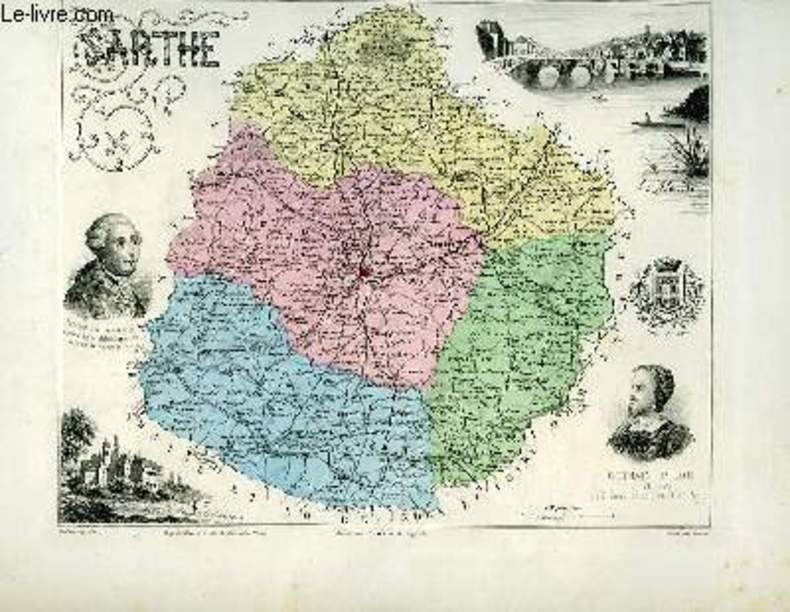
VUILLEMIN A., gravé par FILLATREAU - ISIDORE
1 carte gravée en couleurs de la Sarthe - N°71
IMP. MIGEON. XIXe siècle. In-4. En feuillets. Bon état, Livré sans Couverture, Dos satisfaisant, Intérieur acceptable. Une planche ( de 34.5 x 26.5 cm) illustrée d'une carte en couleurs et de quelques gravures en noir et blanc.. . . . Classification Dewey : 912-Atlas, cartes et plans
书商的参考编号 : RO80091099
|
|
|
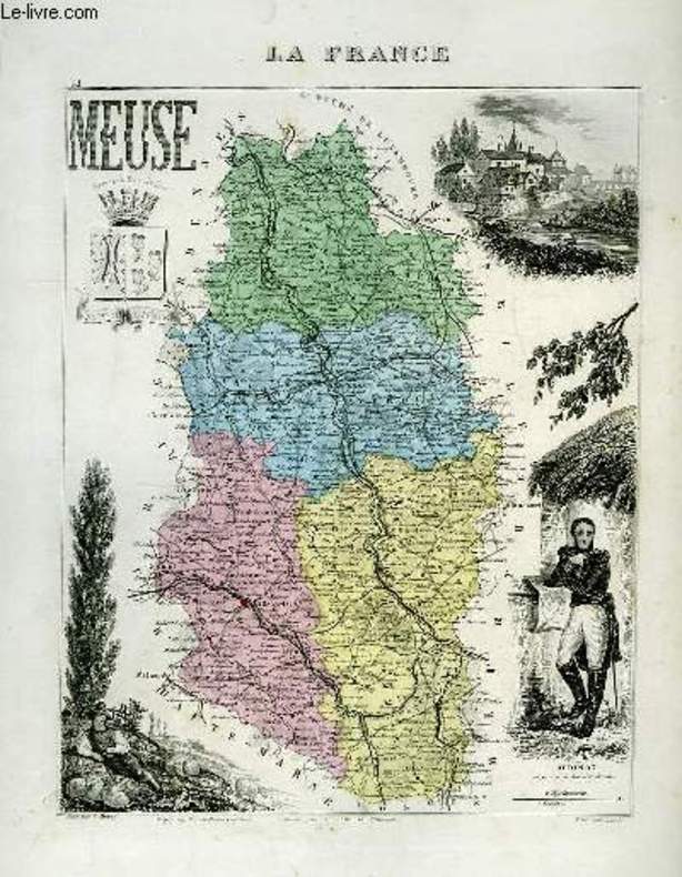
VUILLEMIN A., gravé par VILLEREY - ISIDORE
1 carte gravée en couleurs de la Meuse - N°54
IMP. MIGEON. XIXe siècle. In-4. En feuillets. Bon état, Livré sans Couverture, Dos satisfaisant, Intérieur acceptable. Une planche ( de 34.5 x 26.5 cm) illustrée d'une carte en couleurs et de quelques gravures en noir et blanc.. . . . Classification Dewey : 912-Atlas, cartes et plans
书商的参考编号 : RO80091087
|
|
|
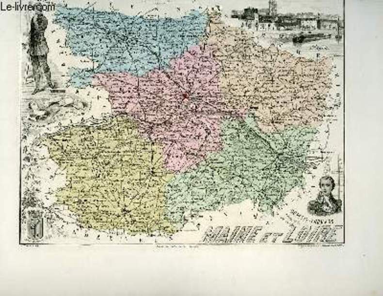
VUILLEMIN A., gravé par FILLATREAU
1 carte gravée en couleurs du Maine et Loire - N°48
IMP. MIGEON. XIXe siècle. In-4. En feuillets. Bon état, Livré sans Couverture, Dos satisfaisant, Intérieur acceptable. Une planche ( de 34.5 x 26.5 cm) illustrée d'une carte en couleurs et de quelques gravures en noir et blanc.. . . A l'italienne. Classification Dewey : 912-Atlas, cartes et plans
书商的参考编号 : RO80091080
|
|
|
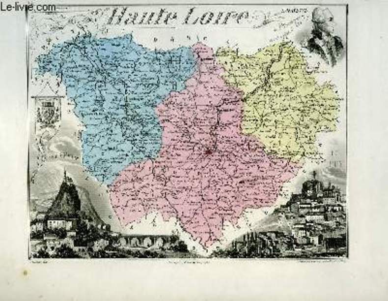
VUILLEMIN A., gravé par FILLATREAU
1 carte gravée en couleurs de la Haute-Loire - N°42
IMP. MIGEON. XIXe siècle. In-4. En feuillets. Bon état, Livré sans Couverture, Dos satisfaisant, Intérieur acceptable. Une planche ( de 34.5 x 26.5 cm) illustrée d'une carte en couleurs et de quelques gravures en noir et blanc.. . . A l'italienne. Classification Dewey : 912-Atlas, cartes et plans
书商的参考编号 : RO80091077
|
|
|
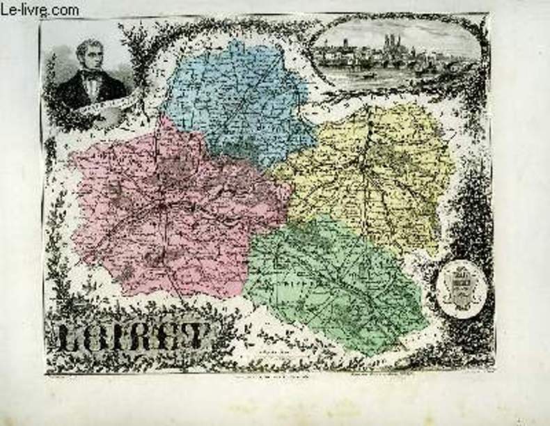
VUILLEMIN A., gravé par ALES - ISIDORE
1 carte gravée en couleurs du Loiret - N°44
IMP. MIGEON. XIXe siècle. In-4. En feuillets. Bon état, Livré sans Couverture, Dos satisfaisant, Quelques rousseurs. Une planche ( de 34.5 x 26.5 cm) illustrée d'une carte en couleurs et de quelques gravures en noir et blanc.. . . A l'italienne. Classification Dewey : 912-Atlas, cartes et plans
书商的参考编号 : RO80091078
|
|
|
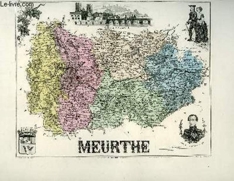
VUILLEMIN A., gravé par VILLEREY - ISIDORE
1 carte gravée en couleurs de la Meurthe - N°53
IMP. MIGEON. XIXe siècle. In-4. En feuillets. Bon état, Livré sans Couverture, Dos satisfaisant, Quelques rousseurs. Une planche ( de 34.5 x 26.5 cm) illustrée d'une carte en couleurs et de quelques gravures en noir et blanc.. . . A l'italienne. Classification Dewey : 912-Atlas, cartes et plans
书商的参考编号 : RO80091084
|
|
|
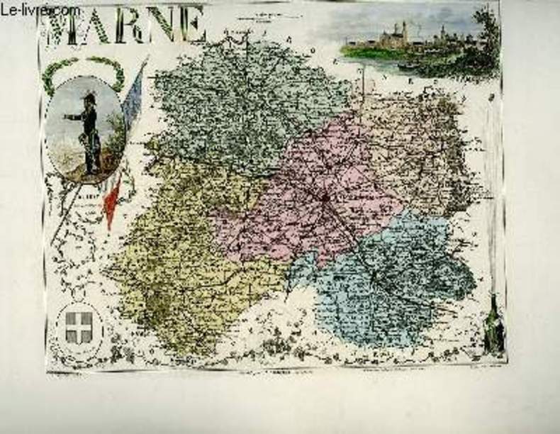
VUILLEMIN A., gravé par ALES - ISIDORE
1 carte gravée en couleurs de la Marne - N°50
IMP. MIGEON. XIXe siècle. In-4. En feuillets. Bon état, Livré sans Couverture, Dos satisfaisant, Intérieur acceptable. Une planche ( de 34.5 x 26.5 cm) illustrée d'une carte en couleurs et de quelques gravures en couleurs.. . . . Classification Dewey : 912-Atlas, cartes et plans
书商的参考编号 : RO80091081
|
|
|
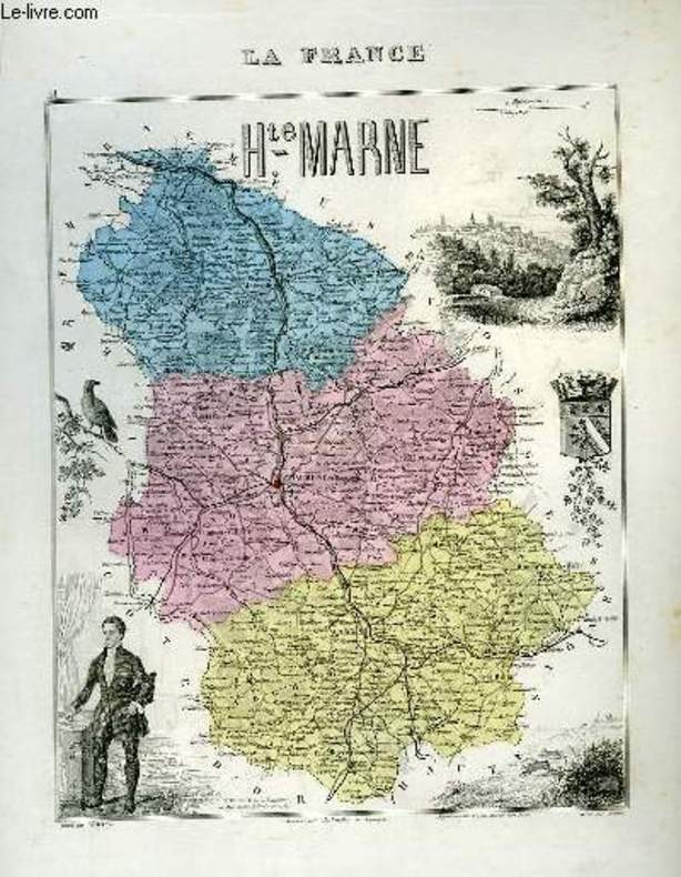
VUILLEMIN A., gravé par VILLEREY - ISIDORE
1 carte gravée en couleurs de la Haute-Marne - N°51
IMP. MIGEON. XIXe siècle. In-4. En feuillets. Bon état, Livré sans Couverture, Dos satisfaisant, Intérieur acceptable. Une planche ( de 34.5 x 26.5 cm) illustrée d'une carte en couleurs et de quelques gravures en noir et blanc. . . . Classification Dewey : 912-Atlas, cartes et plans
书商的参考编号 : RO80091082
|
|
|
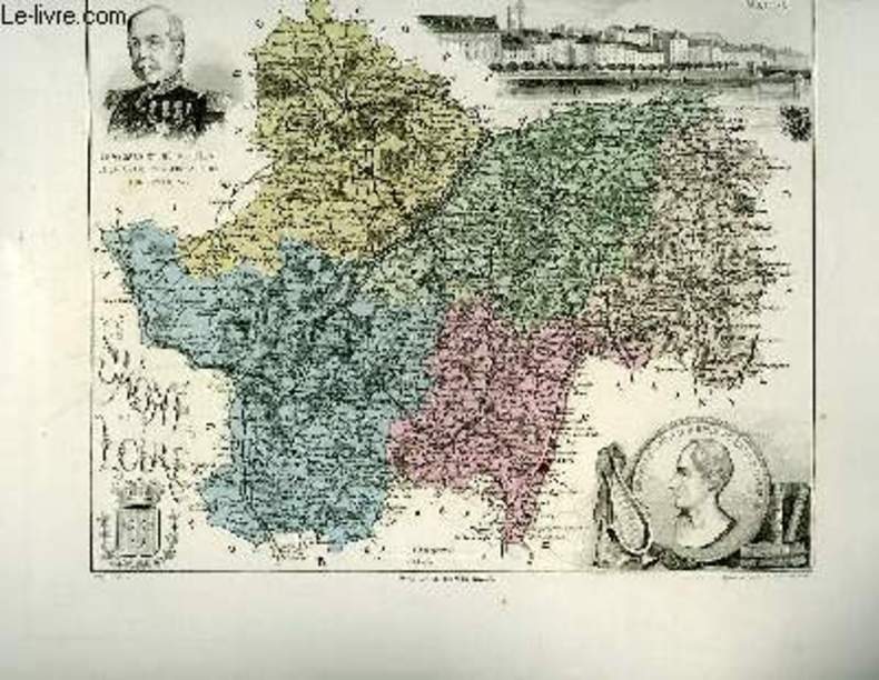
VUILLEMIN A., gravé par FILLATREAU
1 carte gravée en couleurs de la Saône et Loire - N°70
IMP. MIGEON. XIXe siècle. In-4. En feuillets. Bon état, Livré sans Couverture, Dos satisfaisant, Intérieur acceptable. Une planche ( de 34.5 x 26.5 cm) illustrée d'une carte en couleurs et de quelques gravures en noir et blanc.. . . A l'italienne. Classification Dewey : 912-Atlas, cartes et plans
书商的参考编号 : RO80091098
|
|
|
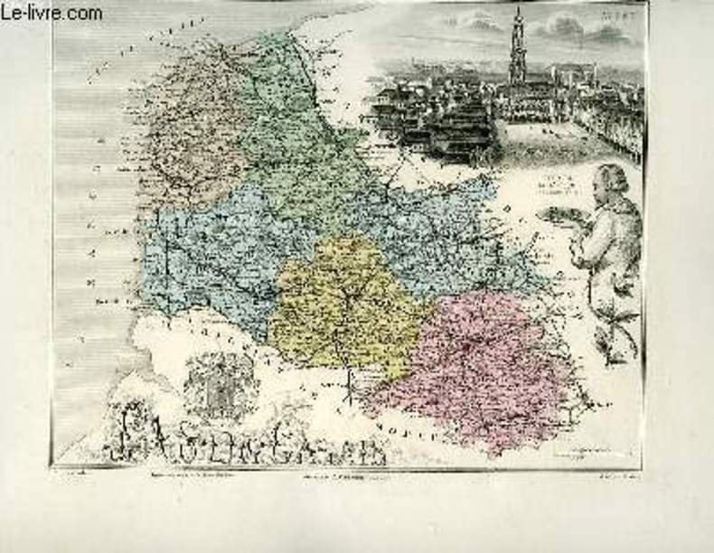
VUILLEMIN A., gravé par ALES - ISIDORE
1 carte gravée en couleurs du Pas-de-Calais - N°61
IMP. MIGEON. XIXe siècle. In-4. En feuillets. Bon état, Livré sans Couverture, Dos satisfaisant, Intérieur frais. Une planche ( de 34.5 x 26.5 cm) illustrée d'une carte en couleurs et de quelques gravures en noir et blanc.. . . A l'italienne. Classification Dewey : 912-Atlas, cartes et plans
书商的参考编号 : RO80091090
|
|
|
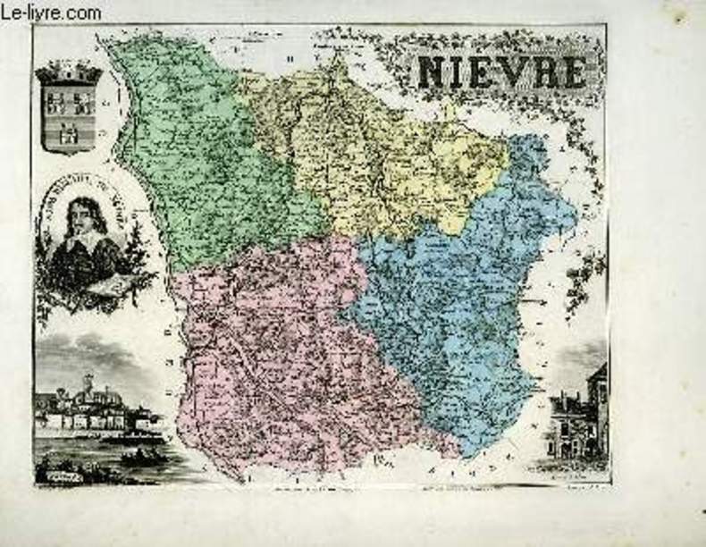
VUILLEMIN A., gravé par VILLEREY - ISIDORE
1 carte gravée en couleurs de la Nièvre - N°57
IMP. MIGEON. XIXe siècle. In-4. En feuillets. Bon état, Livré sans Couverture, Dos satisfaisant, Intérieur acceptable. Une planche ( de 34.5 x 26.5 cm) illustrée d'une carte en couleurs et de quelques gravures en noir et blanc.. . . A l'italienne. Classification Dewey : 912-Atlas, cartes et plans
书商的参考编号 : RO80091089
|
|
|
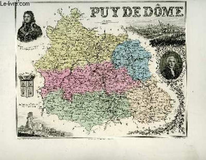
VUILLEMIN A. - ISIDORE
1 carte gravée en couleurs du Puy de Dôme - N°62
IMP. MIGEON. XIXe siècle. In-4. En feuillets. Bon état, Livré sans Couverture, Dos satisfaisant, Intérieur frais. Une planche ( de 34.5 x 26.5 cm) illustrée d'une carte en couleurs et de quelques gravures en noir et blanc.. . . A l'italienne. Classification Dewey : 912-Atlas, cartes et plans
书商的参考编号 : RO80091091
|
|
|
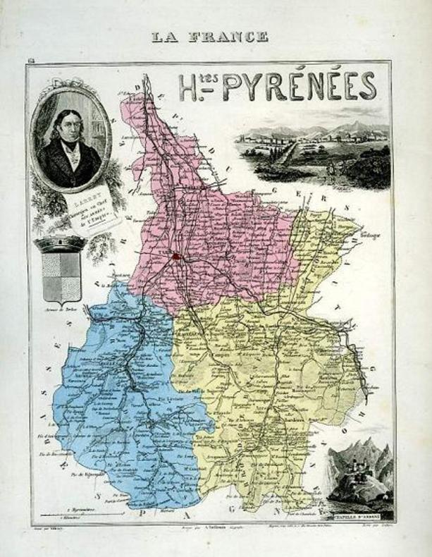
VUILLEMIN A., gravé par VILLEREY - ISIDORE
1 carte gravée en couleurs des Hautes-Pyrénées - N°64
IMP. MIGEON. XIXe siècle. In-4. En feuillets. Bon état, Livré sans Couverture, Dos satisfaisant, Intérieur acceptable. Une planche ( de 34.5 x 26.5 cm) illustrée d'une carte en couleurs et de quelques gravures en noir et blanc.. . . . Classification Dewey : 912-Atlas, cartes et plans
书商的参考编号 : RO80091092
|
|
|
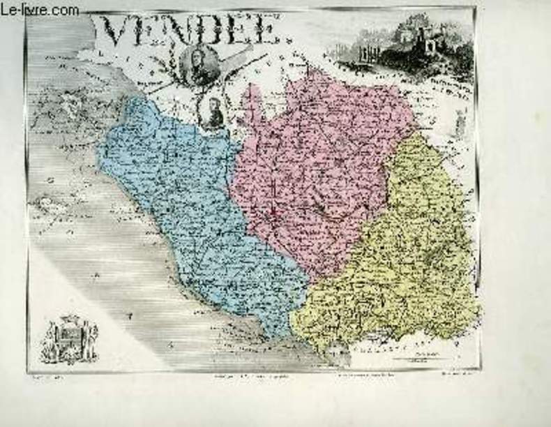
VUILLEMIN A., gravé par MES - ISIDORE
1 carte gravée en couleurs de la Vendée - N°82
IMP. MIGEON. XIXe siècle. In-4. En feuillets. Bon état, Livré sans Couverture, Dos satisfaisant, Intérieur frais. Une planche ( de 34.5 x 26.5 cm) illustrée d'une carte en couleurs et de quelques gravures en noir et blanc.. . . A l'italienne. Classification Dewey : 912-Atlas, cartes et plans
书商的参考编号 : RO80091111
|
|
|
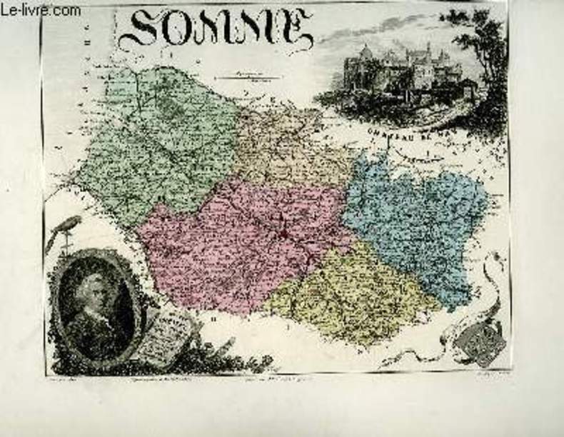
VUILLEMIN A., gravé par ALES - ISIDORE
1 carte gravée en couleurs de la Somme - N°77
IMP. MIGEON. XIXe siècle. In-4. En feuillets. Bon état, Livré sans Couverture, Dos satisfaisant, Intérieur frais. Une planche ( de 34.5 x 26.5 cm) illustrée d'une carte en couleurs et de quelques gravures en noir et blanc.. . . A l'italienne. Classification Dewey : 912-Atlas, cartes et plans
书商的参考编号 : RO80091107
|
|
|
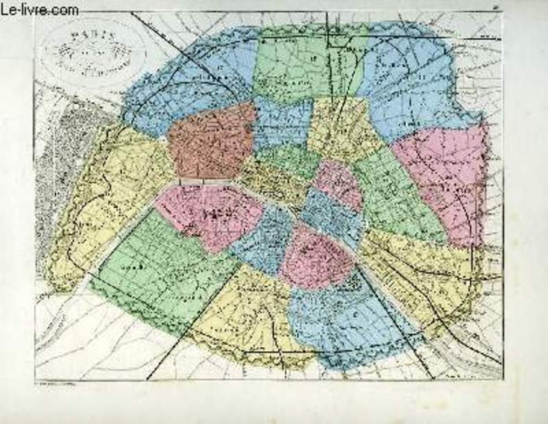
VUILLEMIN A., gravé par GOBERT Th. - ARTUS
1 carte gravée en couleurs de Paris et son Mur d'Enceinte.
IMP. MIGEON. XIXe siècle. In-4. En feuillets. Bon état, Livré sans Couverture, Dos satisfaisant, Intérieur acceptable. Une planche ( de 34.5 x 26.5 cm) illustrée d'une carte en couleurs.. . . A l'italienne. Classification Dewey : 912-Atlas, cartes et plans
书商的参考编号 : RO80091103
|
|
|
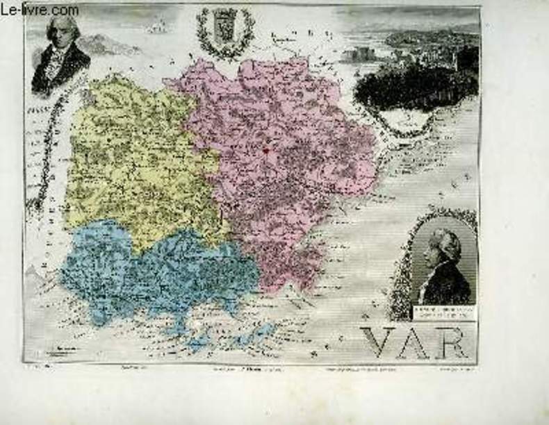
VUILLEMIN A., gravé par ALES - ISIDORE
1 carte gravée en couleurs du Var - N°80
IMP. MIGEON. XIXe siècle. In-4. En feuillets. Bon état, Livré sans Couverture, Dos satisfaisant, Intérieur acceptable. Une planche ( de 34.5 x 26.5 cm) illustrée d'une carte en couleurs et de quelques gravures en noir et blanc.. . . A l'italienne. Classification Dewey : 912-Atlas, cartes et plans
书商的参考编号 : RO80091110
|
|
|
VUILLEMIN A., gravé par DYONNET Ch. - BARBIER
1 carte gravée en couleurs du Tarn et Garonne - N°79
IMP. MIGEON. XIXe siècle. In-4. En feuillets. Bon état, Livré sans Couverture, Dos satisfaisant, Intérieur acceptable. Une planche ( de 34.5 x 26.5 cm) illustrée d'une carte en couleurs et de quelques gravures en noir et blanc.. . . A l'italienne. Classification Dewey : 912-Atlas, cartes et plans
书商的参考编号 : RO80091109
|
|
|
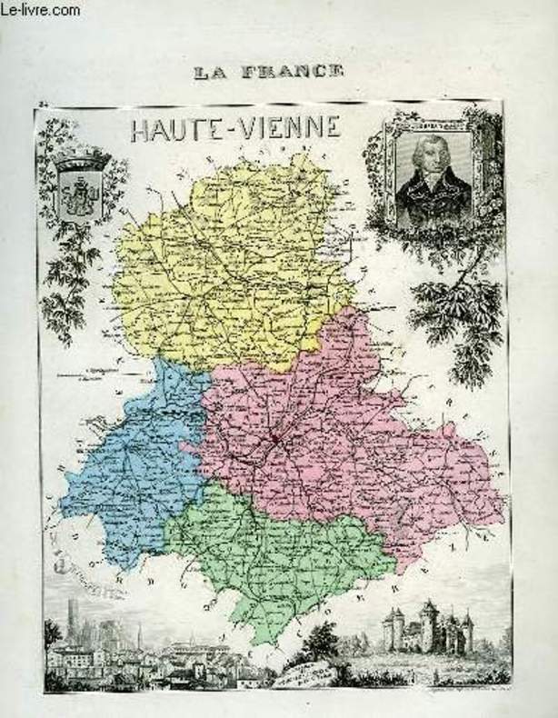
VUILLEMIN A.
1 carte gravée en couleurs de la Haute-Vienne - N°84
IMP. MIGEON. XIXe siècle. In-4. En feuillets. Bon état, Livré sans Couverture, Dos satisfaisant, Intérieur frais. Une planche ( de 34.5 x 26.5 cm) illustrée d'une carte en couleurs et de quelques gravures en noir et blanc.. . . . Classification Dewey : 912-Atlas, cartes et plans
书商的参考编号 : RO80091113
|
|
|
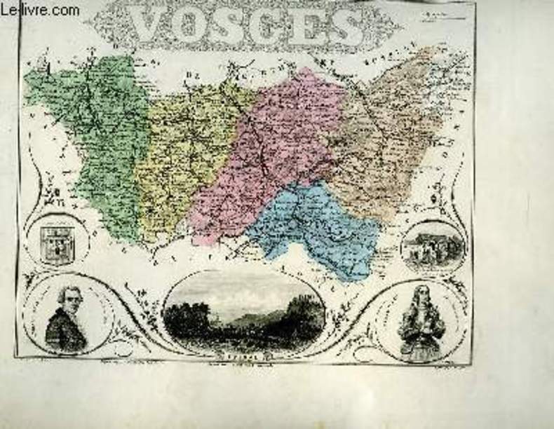
VUILLEMIN A., gravé par ALES - ISIDORE
1 carte gravée en couleurs des Vosges - N°85
IMP. MIGEON. XIXe siècle. In-4. En feuillets. Bon état, Livré sans Couverture, Dos satisfaisant, Intérieur acceptable. Une planche ( de 34.5 x 26.5 cm) illustrée d'une carte en couleurs et de quelques gravures en noir et blanc.. . . A l'italienne. Classification Dewey : 912-Atlas, cartes et plans
书商的参考编号 : RO80091114
|
|
|
VUILLEMIN A.
1 CARTE - BASSIN DE LA SEINE ET BASSINS SECONDAIRES DE LA SOMME, DE L'ORNE ET DE LA VIRE - dimension: 47 x 34.5 cm environs - ECHELLE: 1/1 510 000 Km.
DELALAIN. 1885. In-Plano. En feuillets. Etat d'usage, Couv. convenable, Dos satisfaisant, Intérieur frais. 1 carte en couleur de dimension: 47 x 34.5 cm environs - ECHELLE: 1/1 510 000 Km - 1 legere dechirure sur la pliure.. . . . Classification Dewey : 912-Atlas, cartes et plans
书商的参考编号 : RO20199239
|
|
|
VUILLEMIN A.
1 CARTE - BASSIN DE LA LOIRE ET BASSINS SECONDAIRES DE LA VILAINE, DE LA CHARENTE ET DE LA SEVRE NIORTAISE - dimension: 47 x 34.5 cm environs - ECHELLE: 1/1 850 000 Km.
DELALAIN. 1884. In-Plano. En feuillets. Etat d'usage, Couv. convenable, Dos satisfaisant, Intérieur frais. 1 carte en couleur de dimension: 47 x 34.5 cm environs - ECHELLE: 1/1 850 000 Km - 1 legere dechirure sur la pliure.. . . . Classification Dewey : 912-Atlas, cartes et plans
书商的参考编号 : RO20199238
|
|
|
VUILLEMIN A.
1 CARTE DEPLIANTE - CARTE POLITIQUE ET ADMINISTRATIVE DE LA FRANCE ET DE SES PRINCIPALES COLONIES
DELALAIN FRERES. 1885. In-Plano. En feuillets. Etat d'usage, Couv. convenable, Dos satisfaisant, Intérieur frais. 1 carte depliante en couleur de dimension: 74 x 56 cm environs - ECHELLE: 1/ 2 200 000 Km - nombreux renfors en papier collé au dos de la carte au niveau des pliures.. . . . Classification Dewey : 912-Atlas, cartes et plans
书商的参考编号 : RO20199252
|
|
|
VUILLEMIN A.
1 CARTE - BASSIN DU RHONE ET BASSINS SECONDAIRES DE L'AUBE, DE L'HERAULT, DE L'ARGENS ET DU VAR - dimension: 47 x 34.5 cm environs - ECHELLE: 1/1 760 000 Km.
DELALAIN. 1884. In-Plano. En feuillets. Etat d'usage, Couv. convenable, Dos satisfaisant, Intérieur frais. 1 carte en couleur de dimension: 47 x 34.5 cm environs - ECHELLE: 1/1 760 000 Km - 1 legere dechirure sur la pliure.. . . . Classification Dewey : 912-Atlas, cartes et plans
书商的参考编号 : RO20199240
|
|
|
VUILLEMIN A.
1 CARTE - BASSIN DE LA GARONNE ET BASSINS SECONDAIRES DE L'ADOUR, DE LA LEYRE ET DE LA NIVELLE - dimension: 47 x 34.5 cm environs - ECHELLE: 1/1 450 000 Km
DELALAIN. 1884. In-Plano. En feuillets. Etat d'usage, Couv. convenable, Dos satisfaisant, Intérieur frais. 1 carte en couleur de dimension: 47 x 34.5 cm environs - ECHELLE: 1/1 450 000 Km - 1 legere dechirure sur la pliure.. . . . Classification Dewey : 912-Atlas, cartes et plans
书商的参考编号 : RO20199241
|
|
|
VUILLEMIN A.
1 CARTE - BASSINS DU RHIN, DE LA MEUSE ET DE L'ESCAUT - dimension: 47 x 34.5 cm environs - ECHELLE: 1/2 350 000 Km
DELALAIN. 1884. In-Plano. En feuillets. Etat d'usage, Couv. légèrement passée, Dos satisfaisant, Intérieur frais. 1 carte en couleur de dimension: 47 x 34.5 cm environs - ECHELLE: 1/2 350 000 Km - 1 legere dechirure sur la pliure - bords de la carte tres frottées.. . . . Classification Dewey : 912-Atlas, cartes et plans
书商的参考编号 : RO20199242
|
|
|
VUILLEMIN A.
1 CARTE - BASSINS DE L'ELBE, DE L'OBER ET DU WESER - dimension: 47 x 34.5 cm environs - ECHELLE: 1/2 360 000 Km.
DELALAIN. 1884. In-Plano. En feuillets. Etat d'usage, Couv. convenable, Dos satisfaisant, Intérieur frais. 1 carte en couleur de dimension: 47 x 34.5 cm environs - ECHELLE: 1/2 360 000 Km.. . . . Classification Dewey : 912-Atlas, cartes et plans
书商的参考编号 : RO20199243
|
|
|
VUILLEMIN A.
1 CARTE - BASSINS DE LA VISTULE, DU DNIEPER, DE LA DUNA, DU NIEMEN ET DU DNIESTER - dimension: 47 x 34.5 cm environs - ECHELLE: 1/4 500 000 Km.
DELALAIN. 1884. In-Plano. En feuillets. Etat d'usage, Couv. convenable, Dos satisfaisant, Intérieur frais. 1 carte en couleur de dimension: 47 x 34.5 cm environs - ECHELLE: 1/4 500 000 Km.. . . . Classification Dewey : 912-Atlas, cartes et plans
书商的参考编号 : RO20199244
|
|
|
VUILLEMIN A.
1 CARTE - BASSINS DU VOLGA, DU DON ET DE LA DWIGA - dimension: 47 x 34.5 cm environs - ECHELLE: 1/6 500 000 Km.
DELALAIN. 1884. In-Plano. En feuillets. Etat d'usage, Couv. convenable, Dos satisfaisant, Intérieur frais. 1 carte en couleur de dimension: 47 x 34.5 cm environs - ECHELLE: 1/6 500 000 Km.. . . . Classification Dewey : 912-Atlas, cartes et plans
书商的参考编号 : RO20199245
|
|
|
VUILLEMIN A.
1 CARTE - BASSINS DU DANUBE - dimension: 47 x 34.5 cm environs - ECHELLE: 1/4 000 000 Km
DELALAIN. 1884. In-Plano. En feuillets. Etat d'usage, Couv. convenable, Dos satisfaisant, Intérieur frais. 1 carte en couleur de dimension: 47 x 34.5 cm environs - ECHELLE: 1/4 000 000 Km - 1 legere dechirure sur la pliure.. . . . Classification Dewey : 912-Atlas, cartes et plans
书商的参考编号 : RO20199246
|
|
|
VUILLEMIN A.
1 CARTE - BASSINS DU PO ET DE L'ADIGE - dimension: 47 x 34.5 cm environs - ECHELLE: 1/1 290 000 Km.
DELALAIN. 1884. In-Plano. En feuillets. Etat d'usage, Couv. convenable, Dos satisfaisant, Intérieur frais. 1 carte en couleur de dimension: 47 x 34.5 cm environs - ECHELLE: 1/1 290 000 Km.. . . . Classification Dewey : 912-Atlas, cartes et plans
书商的参考编号 : RO20199247
|
|
|
VUILLEMIN A.
1 CARTE - BASSINS DU TAGE, DU GUADIANA, DU GUADALQUIVIR, DU XACAR ET DE LA SEGURA - dimension: 47 x 34.5 cm environs - ECHELLE: 1/2 220 000 Km.
DELALAIN. 1884. In-Plano. En feuillets. Etat d'usage, Couv. convenable, Dos satisfaisant, Intérieur frais. 1 carte en couleur de dimension: 47 x 34.5 cm environs - ECHELLE: 1/2 220 000 Km.. . . . Classification Dewey : 912-Atlas, cartes et plans
书商的参考编号 : RO20199249
|
|
|
VUILLEMIN A.
1 CARTE - BASSIN DE LA TAMISE ET BASSINS SECONDAIRES DU BLACKWATER DU STOUR ET DU VERSANT DE LA MANCHE - dimension: 47 x 34.5 cm environs - ECHELLE: 1/ 600 000 Km.
DELALAIN. 1884. In-Plano. En feuillets. Etat d'usage, Couv. convenable, Dos satisfaisant, Intérieur frais. 1 carte en couleur de dimension: 47 x 34.5 cm environs - ECHELLE: 1/ 600 000 Km.. . . . Classification Dewey : 912-Atlas, cartes et plans
书商的参考编号 : RO20199250
|
|
|
VUILLEMIN A.
1 CARTE DEPLIANTE - CARTE PHYSIQUE DE L'EUROPE INDIQUANT LES DIVISIONS NATURELLES OROGRAPHIQUES ET HYDROGRAPHIQUES
DELALAIN. 1883. In-Plano. En feuillets. Etat d'usage, Couv. convenable, Dos satisfaisant, Intérieur frais. 1 carte depliante en couleur de dimension: 76 x 55 cm environs - ECHELLE: 1/ 9 500 000 Km - nombreux renfors en papier collé au dos de la carte au niveau des pliures.. . . . Classification Dewey : 912-Atlas, cartes et plans
书商的参考编号 : RO20199253
|
|
|
VUILLEMIN A.
2 CARTES - 1. BASSINS DU TIBRE, DE L'ARNO, DE L'OMBRONE, DU VOLTURNO ET DU GARIGLIANO (ITALIE CENTRALE) + 2. BASSINS DU DOURO ET DU MINHO
DELALAIN. 1884. In-Plano. En feuillets. Etat d'usage, Couv. convenable, Dos satisfaisant, Intérieur frais. 1 planche en couleur de dimension: 47 x 34.5 cm environs contenant 2 cartes en couleur: N°1. BASSINS DU TIBRE, DE L'ARNO, DE L'OMBRONE, DU VOLTURNO ET DU GARIGLIANO (ITALIE CENTRALE) ECHELLE: 1/2 120 000 Km - N°2. BASSINS DU DOURO ET DU MINHO- ECHELLE: 1/ 2 200 000 Km.. . . . Classification Dewey : 912-Atlas, cartes et plans
书商的参考编号 : RO20199248
|
|
|
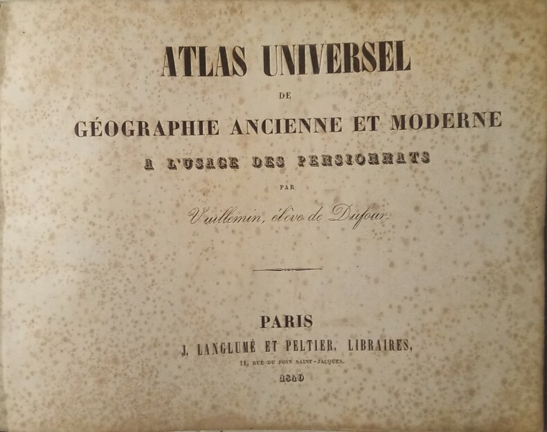
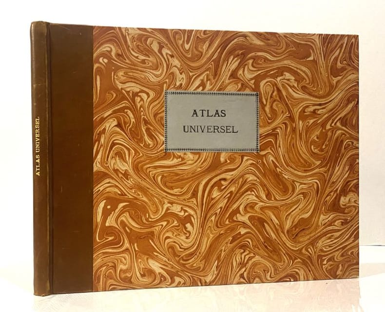
VUILLEMIN
Atlas Universel de Géographie Ancienne et Moderne à l'usage des Pensionnats, par Vuillemin, élève de Dufour.
Paris, J. Langlumé et Peltier, Libraires, 1840. In-4 (25x32cm) oblong relié demi basane marron un peu passé, plats de papier marbré. Quelques rousseurs.
书商的参考编号 : WOC-1374
|
|
|
Vuillemin:
Atlas universel de géographie ancienne et moderne à l'usage des pensionnats par Vuillemin, élève de Dufour. Nouvelle édition, revue et corrigée avec soin.
Paris, J. Langlumé, ca. 1850-60, in-4to oblong, 2 ff. (titre + table avec rousseurs, usées, faux plies) + 50 cartes num. de 1 à 50, gravées en couleurs, (cartes en bon état), ex libris manuscrit ‘ Pauline Fliemann, Osterberg 1870, cartonnage orig., dos toilé, plats marbrés, la reliure est très usé, plats détachés (à relier)
书商的参考编号 : 68781aaf
|
|
|
VUILLEMIN.
Atlas universel de géographie ancienne et moderne à l'usage des pensionnats.
Paris, J. langlumé, 1852. In-4 format à l'italienne (25 x 32 cm) demi basane havane, titre à l'or au dos, plats de papier marbré avec étiquette de titre sur le premier. (Reliure postérieure).
书商的参考编号 : 23368
|
|
|
Vuillemin
ATLAS MIGEON La France et ses Colonies. Atlas illustré. Cent cartes ( COLORISÉES MANUELLEMENT) dressées d'après les cartes de Cassini, du dépôt de la guerre, des ponts-et-chaussées et de la marine.
Paris, Migeon, 1850, in-4 à l'italienne, demi-cuir éditeur, Bon exemplaire. Cartes très fraîches. Frottements à la reliure.
书商的参考编号 : 71412
|
|
|
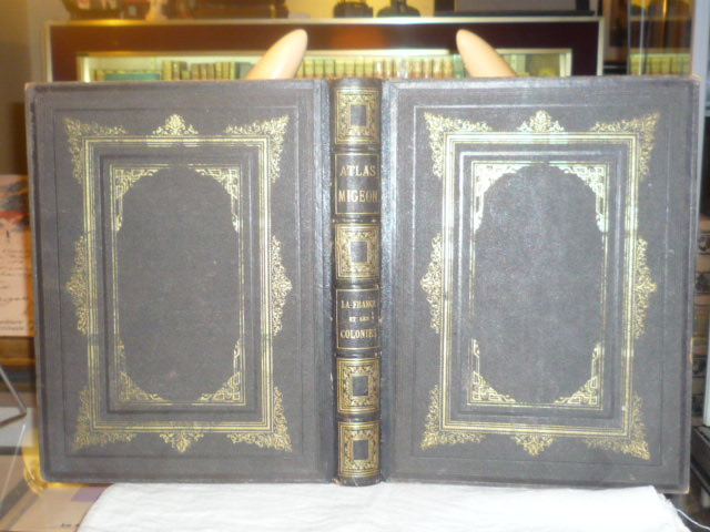
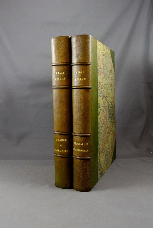
VUILLEMIN
ATLAS MIGEON. La France et ses colonies.
J. Migeon Paris 1880 Atlas grand in-4 ( 360 X 275 mm ), demi-chagrin anthracite, dos à nerfs orné de caissons dorés, plats de percaline chagrinée de la même teinte ornés de décors d'encadrement dorés. Atlas illustré de 105 cartes gravées en couleurs dressées d'aprés les cartes du dépôt de la guerre, des Ponts et Chaussées et de la Marine par M. VUILLEMIN. Toutes les planches des cartes sont aquarellées, ornées de vues, blasons, et portraits de personnages historiques. 5 cartes dépliantes en double page montées sur onglet, et complet des 3 grandes cartes dépliantes in-fine ( France physique administrative et routière, Chemins de fer et télégraphes de France, Chemins de fer européens et voies de communication par mer ). Coins émoussés, bel exemplaire de cet atlas aux cartes très fraîches dans une bonne reliure de l'éditeur.
书商的参考编号 : 381815
|
|
|
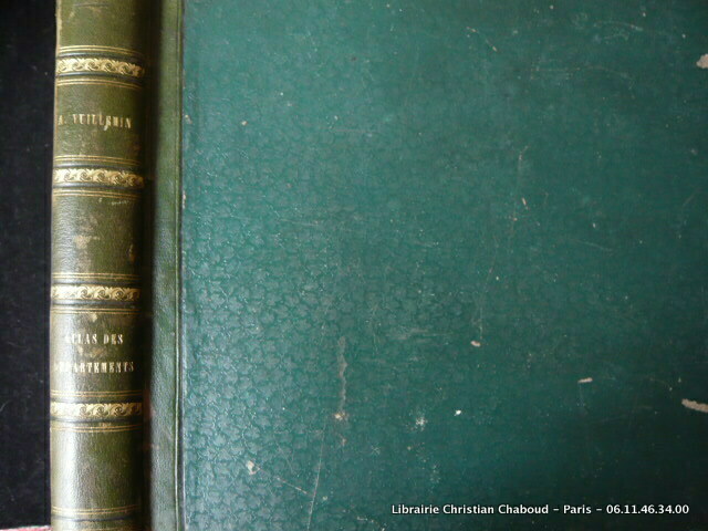
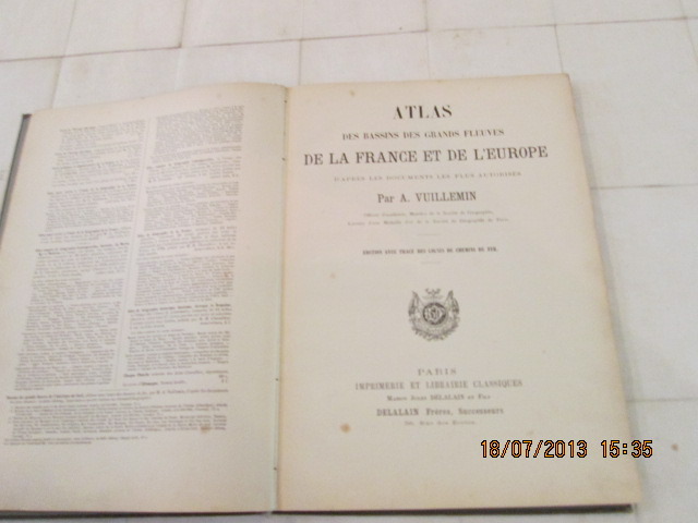
VUILLEMIN A.
Atlas des Bassins des Grandsd Fleuves de la France et de l'Europe
Delalain Frères Paris 1888 In-folio ( 350x250 mm ) pleine percaline brune, titre en noir.D'après les documents les plus autorisés.Edition avec Tracés des Lignes de Chemin de fer.15 cartes en couleurs à double page.1 carte en couleurs dépliante.ATTENTION : Manque une carte.
书商的参考编号 : 251348
|
|
|
VUILLEMIN A., BENARD
Carte Pittoresque des environs de Paris.
BES ET DUBREUIL. 1879. In-Plano. En feuillets. Etat passable, Couv. défraîchie, Dos satisfaisant, Déchirures. Carte dépliante en couleurs, hors-texte, de 85 / 60 cm. Manque le 2nd plat de couverture. Déchirures au niveau des pliures.. . . . Classification Dewey : 912-Atlas, cartes et plans
书商的参考编号 : RO80059650
|
|
|
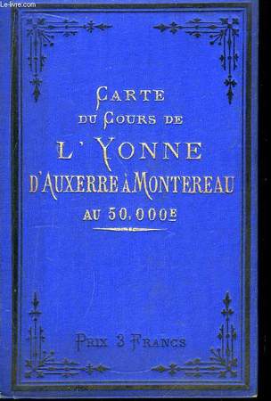
VUILLAUME R. / SIMON A.
Carte du Cours de l'Yonne, d'Auxerre à Montereau, au 50000e.
***. 1888. In-12. Cartonnage d'éditeurs. Bon état, Couv. fraîche, Dos satisfaisant, Intérieur frais. Carte dépliante en couleurs, en panorama de 18 panneaux.. . . . Classification Dewey : 912-Atlas, cartes et plans
书商的参考编号 : RO80059443
|
|
|
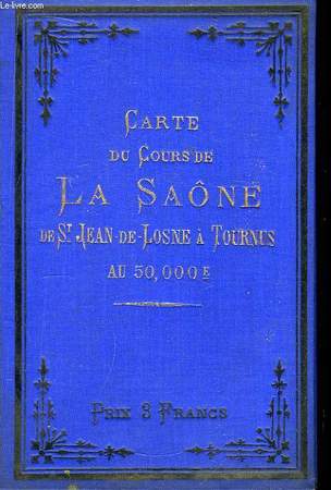
VUILLAUME R. / SIMON A.
Carte du Cours de la Saône, de St-Jean de-Losne à Tourni, au 50000e
***. XIXeme siècle.. In-12. Cartonnage d'éditeurs. Bon état, Couv. fraîche, Dos satisfaisant, Intérieur frais. Carte dépliante en couleurs, en panorama de 16 panneaux.. . . . Classification Dewey : 912-Atlas, cartes et plans
书商的参考编号 : RO80059444
|
|
|
VUILLEMIN, et DYONNET
Carte de France. Aveyron. N°11
IMP. MIGEON. XIXe siècle. In-4. En feuillets. Bon état, Couv. convenable, Dos satisfaisant, Intérieur frais. Une planche de 35 x 26.5 cm, illustrée d'une carte gravée en couleurs.. . . . Classification Dewey : 912-Atlas, cartes et plans
书商的参考编号 : RO80087895
|
|
|
VUILLEMIN (rev.):
Géographie universelle. Atlas-Migeon (revu par Vuillemin) historique, scientifique, industriel et commercial à l’usage des lycées, des séminaires et des familles. Comprenant la géographie, l’histoire, la statistique, etc. D’après les documents authentiques les plus récents. Avec une feuille de texte explicatif mise en regard de chaque carte.
Paris, J. Migeon, 1874. 2 volumes in-folio, vol. 1 non-paginé, vol. 2 de [6]-99 pages. Demi-maroquin vert à coins, dos à nerfs, légèrement passés. Bel état.
书商的参考编号 : 2221
|
|
|
VUILLEMIN A. & CASSINI
La France. Nouvel Atlas Illustré des Départements & des Colonies
MIGEON. Non daté. In-4. Relié demi-cuir. A restaurer, Couv. convenable, Dos satisfaisant, Intérieur acceptable. Album de planches et doubles-planches de cartes en couleurs, incomplet : manque les cartes n°6, 10, 12, 15, 16, 19, 23, 24, 25, 29, 32, 33, 37, 42, 68, 71 bis, 81 et 82. Ouvrage déboité et débroché. Quelques planches volantes. Quelques déchirures sur les dernières cartes dépliantes de l'atlas.. . . . Classification Dewey : 912-Atlas, cartes et plans
书商的参考编号 : RO80114562
|
|
|
VUILLEMIN
LA FRANCE ET SES COLONIES - ATLAS ILLUSTRE - 105 CARTES - DRESSES D'APRES LES CARTES DE CASSINI, DU DEPOT DE LA GUERRE, DES PONTS ET CHAUSSEES ET DE LA MARINE
J.MIGEON. 1871. In-Folio. Relié. A relier, Livré sans Couverture, Dos abîmé, Déchirures. Environ 200 Pages. Nombeuses cartes ne couleur dans et hors texte. Absence de la couveture et du dos. Livre désolidarisé. Nombreuses déchirures et rousseurs. VENDU EN L'ETAT. . . . Classification Dewey : 912-Atlas, cartes et plans
书商的参考编号 : RO80178149
|
|
 ?????????
 ?????PDF???
 RSS feed


