|
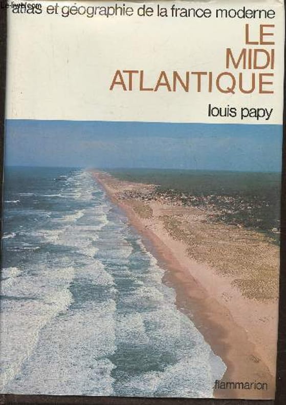
Papy Louis
Atlas et géographie du Midi Atlantique- Portrait de la France moderne
Flammarion. 1982. In-4. Relié. Bon état, Coins frottés, Dos satisfaisant, Papier jauni. 428 pages. Jaquette correcte. Quelques rousseurs. Signet conservé. Nombreuses photos et cartes en noir et blanc et en couleurs, in et hors texte.. Avec Jaquette. . . Classification Dewey : 912-Atlas, cartes et plans
Bookseller reference : RO30374546
|
|
|
PAPY LOUIS
LE MIDI ATLANTIQUE - ATLAS ET GEOGRAPHIE DE LA FRANCE MODERNE
FLAMMARION. 1982. In-8. Relié. Bon état, Couv. convenable, Dos satisfaisant, Intérieur frais. 428 pages - nombreuses photos et cartes en noir et blanc et en couleurs dans et hors texte - contre-plats illustrés en couleurs - 1er plat de la jaquette illustré en couleur - 1 accroc sur le 2eme plat de la jaquette.. Avec Jaquette. . . Classification Dewey : 912-Atlas, cartes et plans
Bookseller reference : RO20193816
|
|
|
PAQUIER (J.-B.)
Atlas de géographie physique et militaire de l'Europe et du bassin de la Méditerranée.
Paris, Emile Bertaux, s.d. [1888]. Petit in-folio, cartonnage de l’époque, dos renforcé postérieurement, non paginé: [2]ff., 6 cartes en couleurs sur double page et 4 tableaux, également sur double page.
Bookseller reference : 566159

|
|
|
PARENTI Umberto
"Atlas de zoologie, tome 1 : Des protozoaires aux insectes; tome 2 : Des mollusques aux vertébrés. (2 volumes). Collection des dictionnaires Atlas."
Paris, Grange Batelière, 1972. 15 x 23, 2 volumes, 113 + 115 pages, 94 planches en couleurs, cartes, cartonnage d'édition, très bon état.
Bookseller reference : 26748
|
|
|
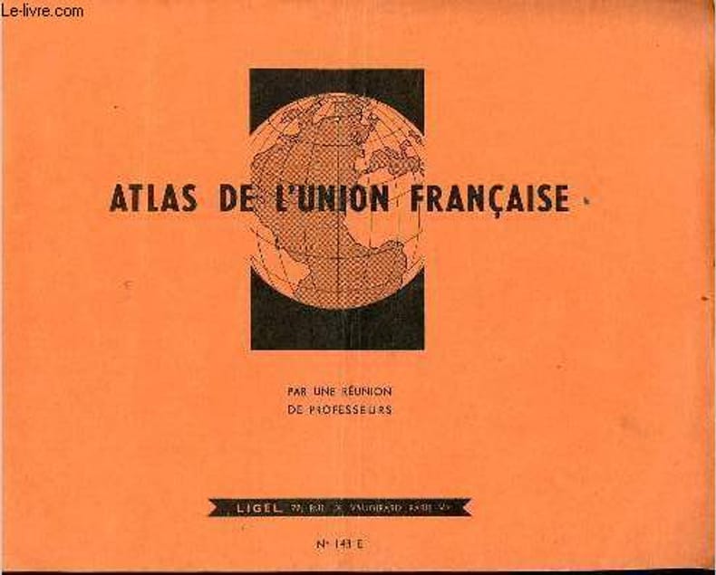
Par une réunion de professeurs
Atlas de l'union française - n°143 E.
Ligel. non daté. In-4. Broché. Etat d'usage, Couv. légèrement pliée, Agrafes rouillées, Intérieur acceptable. 32 pages agrafées de cartes en couleurs.. . . A l'italienne. Classification Dewey : 912-Atlas, cartes et plans
Bookseller reference : R160219191
|
|
|
PARIS-SOIR
Carte des Balkans et du Proche-Orient.
CHEZ L'AUTEUR. Non daté. In-Plano. En feuillets. Bon état, Couv. convenable, Dos satisfaisant, Intérieur frais. Carte dépliante en couleurs, de 78/59cm, hors-texte. Pas de plats de couverture. Quelques parties rajoutées aux crayons de couleurs.. . . . Classification Dewey : 912-Atlas, cartes et plans
Bookseller reference : RO80010930
|
|
|
Par François Cali
Dictionnaire pittoresque de la France. rene jacques. lucien herve. ronis. sudre. cartier bresson. brassai. denise colomb
Ed. Arthaud 1955 In-4 relié, tranches légèrement ternies, charnière intérieures fragiles. Pas de jaquette. En l’état.
Bookseller reference : 73696
|
|
|
PARIS, Alain
Dictionnaire des interprètes et de l'interprétation musicale depuis 1900
2004 Editions Robert Laffont, collection "Bouquins" fondée par Guy Schoeller - 2004 - In-8, broché - 1289 pages
Bookseller reference : 88851
|
|
|
PAR UNE REUNION DE PROFESSEURS
GEOGRAPHIE-ATLAS DU COURS MOYEN - LA FRANCE - LA TERRE.
MAISON A. MAME ET FILS / DE GIGORD J.. 1912. In-4. Relié. Bon état, Couv. convenable, Dos satisfaisant, Intérieur frais. 64 pages augmentées de nombreuses illustrations en noir et blanc dans le texte - et nombreuses cartes en couleurs dans et hors texte -. . . . Classification Dewey : 912-Atlas, cartes et plans
Bookseller reference : R320078375
|
|
|
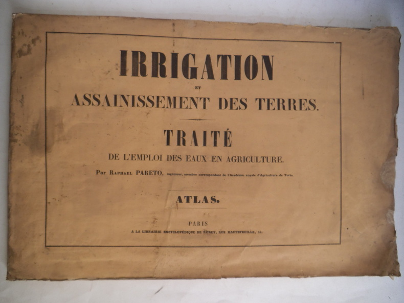
PARETO Raphaël
Irrigation et assainissement des terres
Traité de l’emploi des eaux en agriculture.Atlas in 4 à l’italienne,broché, titre sur le premier plat,catalogue au deuxième plat,titre et à la suite 40 planches gravées par GUIGUET d’après l’auteur dont 7 dépliantes.A la librairie Roret sans date pâle mouillure angle inférieur gauche en début de volume,deux déchirures réparées.Couverture légèrement poussiéreuse,sinon bon état d’ensemble
Bookseller reference : 6225
|
|
|
Pastis 51
Carte officielle de l'Ocean Atlantique : trajet Lorient - Les Bermudes. La Transat - Le Point - Europe 1
Pastis 51. 1983. In-4. Broché. Bon état, Couv. convenable, Dos satisfaisant, Papier jauni. Une carte en couleur d'envrion 50cm par 80cm.. . . . Classification Dewey : 912-Atlas, cartes et plans
Bookseller reference : RO30346083

|
|
|
PASQUET HEDWIGE- MARCHAND PIERRE- BLISS ANNICK...
Grand atlas pour le XXIe siecle
FRANCE LOISIRS / NOUVEAUX LOISIRS. 1998. In-4. Relié. Etat d'usage, Couv. convenable, Dos satisfaisant, Quelques rousseurs. 335 PAGES illustrées en couleur (cartes et photos) - Contreplats et gardes illustrés de cartes en couleur - Jaquette en état d'usage : coins et coiffes abîmés. Avec Jaquette. . . Classification Dewey : 912-Atlas, cartes et plans
Bookseller reference : RO20274881 ISBN : 274411569

|
|
|
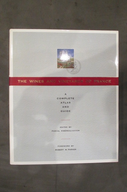
Pascal Ribéreau-Gayon
THE WINES AND VINEYARDS OF FRANCE. A complete Atlas and Guide.
1990 / 256 pages. relié avec jaquette. Editions Viking Langue : Anglais
Bookseller reference : VIN020M
|
|
|
Pasche, Perdita
ADAC Ski Atlas Alpen. Skigebiete - Die schönsten Wintersportregionen
München, Osterfildern, ADAC Verlags GmbH, 1991. 616 Seiten , 30 cm , Hardcover/Pappeinband
Bookseller reference : 49539

|
|
|
Past Worlds: The Times Atlas of Archaeology Christopher Scarre Scarre
Past Worlds: The Times Atlas of Archaeology Christopher
Fine. Like new. Clean straight papers. Dust cover missing. unknown
Bookseller reference : 5P-MPAW-TB9T ISBN : 0723003068 9780723003069

|
|
|
PATRICK MERIENNE
ATLAS de la France et de ses régions
EDITIONS OUEST FRANCE. 2001. In-8. Broché. Bon état, Couv. convenable, Dos satisfaisant, Intérieur frais. 48 pages. Nombreuses cartes en couleur. . . . Classification Dewey : 912-Atlas, cartes et plans
Bookseller reference : R240020894
|
|
|
PATRICK MERIENNE
ATLAS des explorations et des découvertes
EDITIONS OUEST FRANCE. 2005. In-8. Broché. Bon état, Couv. convenable, Dos satisfaisant, Intérieur frais. 48 pages. Nombreuses cartes en couleur. . . . Classification Dewey : 912-Atlas, cartes et plans
Bookseller reference : R240020895
|
|
|
Patrick David
ATLAS MONDIAL (2010-2011)
Auzou 2010 160 pages 25 4x2x29 6cm. 2010. Broché. 160 pages.
Bookseller reference : 500153847

|
|
|
Patrick MERIENNE
PETIT ATLAS de FRANCE
Un ouvrage de 49 pages, format 165 x 230 mm, illustré, broché couverture couleurs, publié en 1993, Editions Ouest-France, bon état
Bookseller reference : LFA-126734318
|
|
|
PATRICK MERIENNE
PETIT ATLAS DE LA FRANCE DEPARTEMENTS ET TERRITOIRES D'OUTRE MER
EDITIONS OUEST FRANCE. 1997. In-8. Broché. Etat d'usage, Couv. légèrement passée, Dos satisfaisant, Intérieur acceptable. 48 pages. Couverture en couleurs. Nombreuses cartographies en couleurs hors texte.. . . . Classification Dewey : 912-Atlas, cartes et plans
Bookseller reference : RO70122857
|
|
|
PAULVE DOMINIQUE ; Mulliez Frank (photographie)
FRANCE GRANDEUR NATURE
GRUND 2012 In-4 relié 34,8 cm sur 27,2. 300 pages. Très bon état d’occasion.
Bookseller reference : 73677
|
|
|
Paul Vidal de La Blache, Louis Gaillois (ss la dir. de)
Géographie Universelle (20 volumes)
1927-1942, Armand Colin, Paris. 20 volumes sur les 23 parus (incomplet des tomes VI partie 2, XI partie 2 et XII). In-4, reliés, demi-basane à coins, dos à nerfs, couvertures conservées, tranches de tête dorées. Géographie illustrée de nombreuses planches en noir. I : Les îles britanniques (1927). II : Belgique. Pays-Bas, Luxembourg ( 1927). III : États scandinaves, régions polaires boréales (1933). IV : L'Europe centrale (deux vols. 1930-1). V : États de la Baltique, Russie (1932). IV, partie 1 : France physique (1942). VII, parties 1 et 2 : Méditerranée et péninsules méditerranéennes. VIII : Asie occidentale - La Haute Asie (1927). IX : Asie de Moussons (deux vols. 1928-9). X : Océanie, Régions polaires australes (1930). XI partie 1 : Afrique septentrionale et occidentale (1937). XIII partie I et II : Amérique septentrionale (1935-6). XIV : Mexique et Amérique cenrrale (1928). XV : Amérique du Sud (1927).
Bookseller reference : HIS5040M
|
|
|
PAULY, G. ; HAUSERMANN, R.
La France et ses Colonies.
Atlas dressé d'après le plan d'Etudes des Ecoles Primaires Supérieures et de l'Enseignement Secondaire (arrêtes des 22 janvier 1885 et 18 janvier 1887) à l'usage des aspirants et aspirantes à tous les examens d'enseignements primaire et secondaire et aux divers concours pour l'admission dans les administrations publiques, 1 vol. in-8 cartonnage éditeur demi-percaline plat sup. illustré, Gustave Guérin & Cie, Paris, s.d. (1889), avec 42 cartes en couleurs
Bookseller reference : 33936

|
|
|
Pauly G./Hausermann R.
Nouvelle méthode de géographie - Enseignement spécial de la géographie - Atlas universel de géographie - Cours supérieur
Gustave Guérin et Cie. Non daté. In-8. Relié. A relier, Coins frottés, Dos abîmé, Quelques rousseurs. 44 + 141 + 76 pages - nombreuses cartes en couleurs hors texte - quelques illustrations en noir et blanc dans le texte. Texte sur plusieurs colonnes. Non daté, vers 1896. Signature à l'encre en page de garde. 1er cahier quasiment désolidarisé. 1er plat désolidarisé. Dos toilé déchiré, manquant. 2e plat frotté.. . . . Classification Dewey : 912-Atlas, cartes et plans
Bookseller reference : R300283041

|
|
|
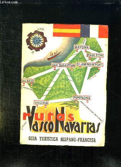
PAU RICO JOSE ANDRES.
RUTAS VASCO NAVARRAS 1960. TEXTE EN ESPAGNOL ET EN FRANCAIS.
CHEZ L AUTEUR.. 1959. In-8. Broché. Etat d'usage, Couv. légèrement passée, Dos plié, Intérieur acceptable. 282 pages. Nombreuses photos en noir et blanc dans le texte. Nombreuses cartes en couleurs dépliante hors texte.. . . . Classification Dewey : 912-Atlas, cartes et plans
Bookseller reference : R150165824
|
|
|
PAULET (V.) - SARAZIN (Jules)
Traité d'anatomie topographique. Atlas. Tome deuxième. Les membres.
Paris, Victor Masson et Fils, 1869, in-4° en feuillets, de la 76 planches accompagnées chacune d'un feuillet de texte explicatif, chemise à liens.
Bookseller reference : ZNC-511
|
|
|
PAU RICO JOSE ANDRES.
RUTAS VASCO NAVARRAS 1960. TEXTE EN ESPAGNOL ET EN FRANCAIS.
CHEZ L AUTEUR.. 1959. In-8 Carré. Broché. Etat d'usage. Couv. légèrement passée. Dos plié. Intérieur acceptable. 282 pages. Nombreuses photos en noir et blanc dans le texte. Nombreuses cartes en couleurs dépliante hors texte.

|
|
|
Paul Sidney Martin John Beach Rinaldo William Atlas Longacre
Mineral Creek Site And Hooper Ranch Pueblo Eastern Arizona: Fieldiana Anthropology V52
Literary Licensing LLC 2012-10-06. Hardcover. Good. Literary Licensing, LLC hardcover
Bookseller reference : SONG1258486695 ISBN : 1258486695 9781258486693
|
|
|
Paulusch, Clemens
Deutschland in historischen Karten. [1. Auflage]
Berlin : Elsengold [2019]. 1 Atlas (207 Seiten) ; 34 cm, mit Schutzumschlag Festeinband, gebundene Ausgabe, Hardcover/Pappeinband, Exemplar in sehr gutem Erhaltungszustand
Bookseller reference : 60428

|
|
|
PAULY, G. ; HAUSERMANN, R.
La France et ses Colonies.
Atlas dressé d'après le plan d'Etudes des Ecoles Primaires Supérieures et de l'Enseignement Secondaire (arrêtes des 22 janvier 1885 et 18 janvier 1887) à l'usage des aspirants et aspirantes à tous les examens d'enseignements primaire et secondaire et aux divers concours pour l'admission dans les administrations publiques, 1 vol. in-8 cartonnage éditeur demi-percaline plat sup. illustré, Gustave Guérin & Cie, Paris, s.d. (1889), avec 42 cartes en couleurs Editon originale. Bon état (couv. lég. frottée, cachet d'hommage des éditeurs et de l'exposition universelle de Paris 1889 - Médaille d'argent) pour cet atlas peu commun. Français

|
|
|
Pause, Walter [Bearb.], und Michael [Bearb.] Pause
Leichte Bergtouren in den Alpen : Bergwandern / Walter Pause. Neubearb.: Michael Pause.
Stuttgart ; München : Deutscher Bücherbund, [1987]. 143 S. zahlr. Ill. (z.T. farb.), Kt.-Skizzen Gr. 8°. Lizenzausg. Ill. OPpbd.
Bookseller reference : 32323
|
|
|
Pautner, Norbert [Red.]/Barnitzke, Heike
Neuer grosser Atlas der Welt. 64 Seiten Länderlexikon in Farbe.
Köln, Serges Medien 1997. gen. Lizenzausg. 36 cm. VIII, 360 S., Ill., zahlr. Kt. Pp., verg. Rü.-u. Deck.-Tit., i. Schuber. Sehr guter Zust., sauber erhalten.
Bookseller reference : 51078AB
|
|
|
PAVIE (Auguste) - [ATLAS] [MISSION PAVIE] -
Mission Pavie - Indo-Chine - Atlas - Notices et Cartes
Paris, Augustin Challamel, Editeur, 1903. 1 volume in-4, 54 pp., présence de quelques cachets de bibliothèque, reliure moderne plein cuir bordeaux, enrichi de 9 planches de cartes en couleurs, très bon état.
Bookseller reference : 9647
|
|
|
PAVIE (Auguste) - [INDOCHINE] [CHINE] [MISSION PAVIE] [ATLAS]
Mission Pavie - Indo-Chine - Atlas - Notices et Cartes
Paris, Augustin Challamel, Editeur, 1903. 1 volume in-4, 54 pp., présence de quelques cachets de bibliothèque, reliure ancienne dos toilé imitation serpent, plats cartonnés marbrés, quelques rousseurs, enrichi de 9 planches de cartes en couleurs, très bon état.
Bookseller reference : 11420
|
|
|
PAVIE (Auguste) - [INDOCHINE] [CHINE] [MISSION PAVIE] [ATLAS]
Mission Pavie - Indo-Chine - Atlas - Notices et Cartes
Paris, Augustin Challamel, Editeur, 1903. 1 volume in-4, 54 pp., présence de quelques cachets de bibliothèque, reliure ancienne dos toilé imitation serpent, plats cartonnés marbrés, quelques rousseurs, enrichi de 9 planches de cartes en couleurs, très bon état.
Bookseller reference : 11968
|
|
|
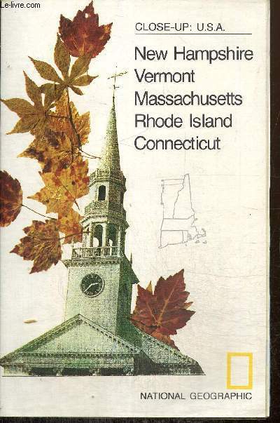
Payne Melvin M. & Collectif
Carte : Close-Up, U.S.A. - Western New England
National Geographic Society. 1975. In-Plano. En feuillets. Bon état, Livré sans Couverture, Dos satisfaisant, Intérieur frais. Une carte dépliante en couleurs recto-verso. Nombreuses illustrations en couleurs au verso. Texte en anglais. Echelle : 1/614600. 88 x 56 cm environ.. . . . Classification Dewey : 912-Atlas, cartes et plans
Bookseller reference : RO80251211
|
|
|
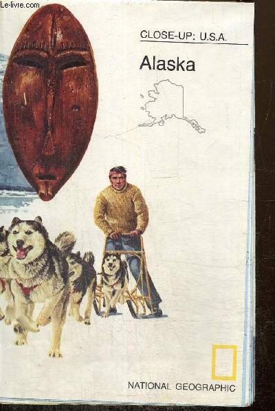
Payne Melvin M. & Collectif
Carte : Close-up, U.S.A. - Alaska
National Geographic Society. 1975. In-Plano. En feuillets. Bon état, Livré sans Couverture, Dos satisfaisant, Intérieur frais. Une carte dépliante en couleurs recto-verso. Nombreuses illustrations en couleurs au verso. Texte en anglais. Echelle : 1/3295000. 56 x 88 cm environ.. . . . Classification Dewey : 912-Atlas, cartes et plans
Bookseller reference : RO80251216
|
|
|
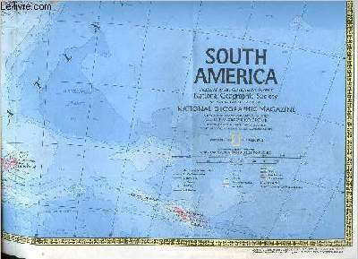
Payne Melvin M. & Collectif
Carte : South America
National Geographic Society. 1972. In-Plano. En feuillets. Bon état, Livré sans Couverture, Dos satisfaisant, Intérieur frais. Une carte dépliante en couleurs recto-verso. Texte en anglais. 76 x 58 cm. Echelle : 1/10700000.. . . . Classification Dewey : 912-Atlas, cartes et plans
Bookseller reference : RO80251167
|
|
|
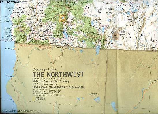
Payne Melvin M. & Collectif
Carte : Close-up : U.S.A., The Northwest
National Geographic Society. 1973. In-Plano. En feuillets. Bon état, Livré sans Couverture, Dos satisfaisant, Intérieur frais. Une carte dépliante en couleurs recto verso. Texte en anglais. Echelle : 1/2000000. 58 x 88 cm environ. Nombreuses illustrations en couleurs au verso.. . . . Classification Dewey : 912-Atlas, cartes et plans
Bookseller reference : RO80251173
|
|
|
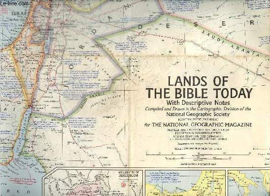
Payne Melvin M. & Collectif
Carte : Lands of the Bible today with Descrptive Notes
National Geographic Society. 1967. In-Plano. En feuillets. Bon état, Livré sans Couverture, Dos satisfaisant, Intérieur frais. Une carte dépliante en couleurs. Texte en anglais. Echelle : 1/2851200. Environ 75 x 104 cm.. . . . Classification Dewey : 912-Atlas, cartes et plans
Bookseller reference : RO80251174
|
|
|
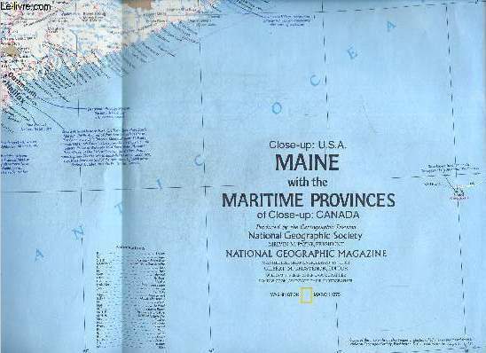
Payne Melvin M. & Collectif
Carte : Close-up : U.S.A. : Maine with the maritime provinces
National Geographic Society. 1975. In-Plano. En feuillets. Bon état, Couv. convenable, Dos satisfaisant, Intérieur frais. Une carte dépliante en couleurs recto-verso. Texte en anglais. Echelle : 1/1050000. 58 x 88 cm environ. Nombreuses illustrations en couleurs au verso.. . . . Classification Dewey : 912-Atlas, cartes et plans
Bookseller reference : RO80251176
|
|
|
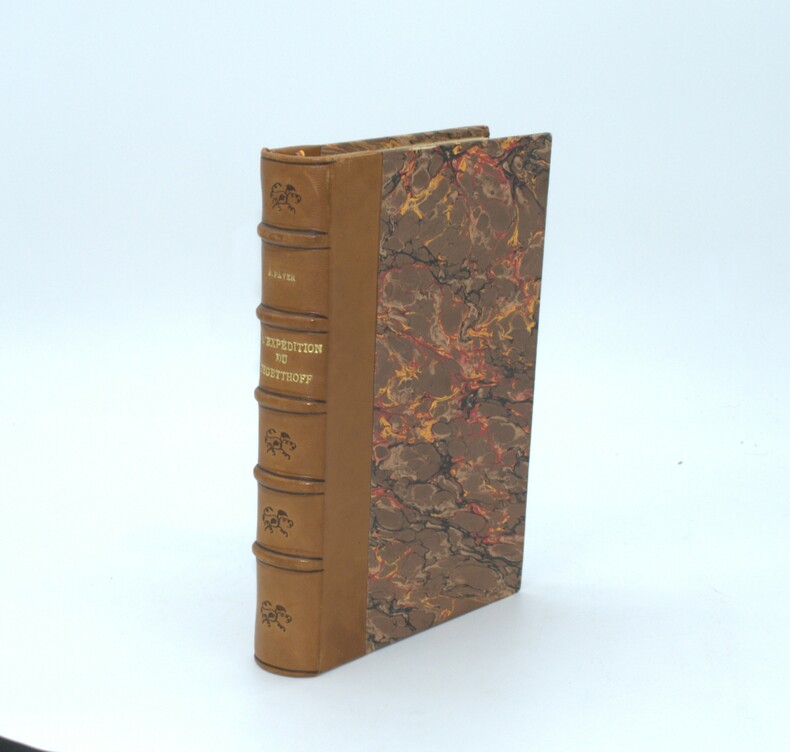
PAYER J.
L'Expédition du Tegetthoff. Voyage de découvertes aux 80e-83e degrés de latitude Nord. Traduit de l'allemand avec l'autorisation de l'auteur par M. Jules Gourdault et contenant 68 gravures sur bois et 2 cartes.
Paris, Librairie Hachette et Cie, 1878. 24 x 16 cm, [4]-381 p. Relié, demi-chagrin moderne , dos à nerfs avec auteur et titre , couverture conservée ( en partie ) , ex-libris , rousseurs éparses.
Bookseller reference : PHO-1335
|
|
|
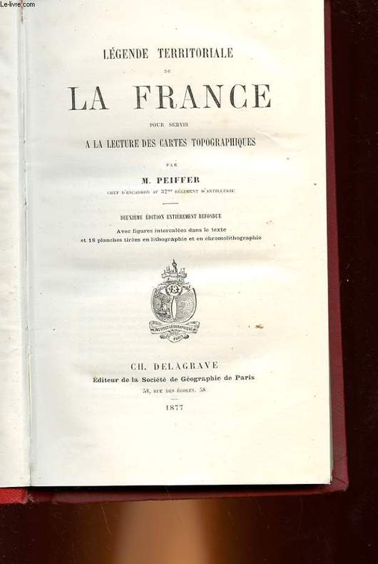
PEIFFER M.
LEGENDE TERRITORIALE DE LA FRANCE POUR SERVIR A LA LECTURE DES CARTES TOPOGRAPHIQUES
CH. DELAGRAVE - 2° EDITION. 1877. In-8. Cartonnage d'éditeurs. Etat d'usage, Couv. convenable, Mors fendus, Intérieur frais. 226 pages. Nombreuses gravures et cartes en noir et blanc dans le texte et hors texte.. . . . Classification Dewey : 912-Atlas, cartes et plans
Bookseller reference : RO30095153
|
|
|
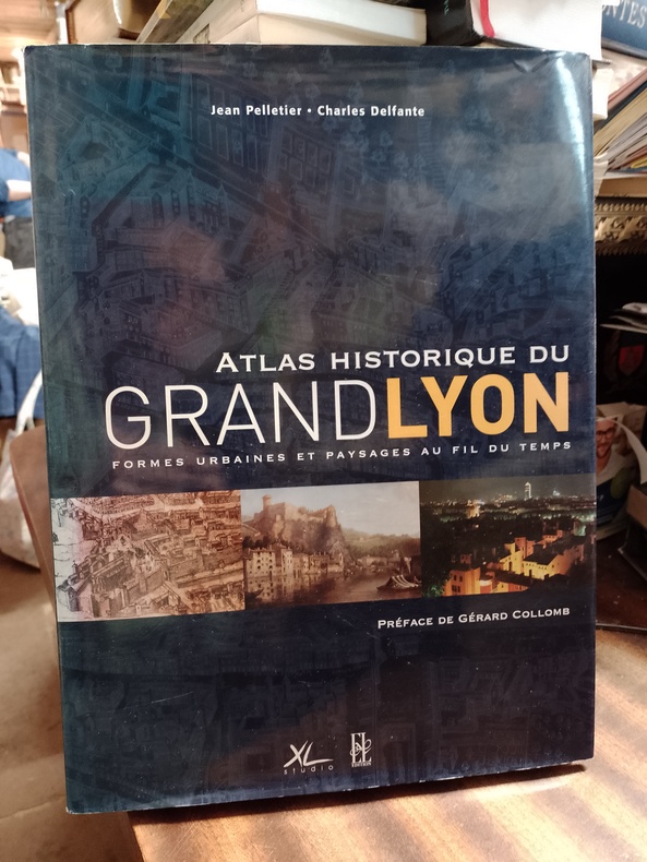
PELLETIER Jean et DELFANTE Charles
Atlas historique du Grand Lyon - Formes urbaines et paysages au fil du temps
Lyon, Editions Xavier Lejeune - Libris, 2004, 27 x 36,50, 256 pages sous cartonnage éditeur et jaquette illustrés. Iconographie noir & blanc et couleurs.
Bookseller reference : LYONNNN67140623
|
|
|
PELTIER G.
Carte de l'Europe en 1919
L'ILLUSTRATION. Non daté. In-Plano. En feuillets. Bon état, Couv. convenable, Dos satisfaisant, Intérieur frais. Carte dépliante en couleurs, de 20/58 cm. Pas de plats de couverture.. . . . Classification Dewey : 912-Atlas, cartes et plans
Bookseller reference : RO80010929
|
|
|
PELTIER G.
Carte de la Guerre Européenne. Feuillet Nord-Est.
L'ILLUSTRATION. 2 janvier 1915. In-Folio. En feuillets. Bon état, Livré sans Couverture, Dos satisfaisant, Intérieur frais. Carte dépliante en noir et blanc de 40 / 48 cm. . . A l'italienne. Classification Dewey : 912-Atlas, cartes et plans
Bookseller reference : RO80072052
|
|
|
PELET Général.
Carte de Sierck S.O.
DEPOT GENERAL DE LA GUERRE. 1901. In-Folio. Relié. Bon état, Couv. convenable, Dos satisfaisant, Intérieur bon état. Carte en planche dépliante en noir et blanc de 45/31 cm. Pas de plats de couverture. Pliures.. . . A l'italienne. Classification Dewey : 912-Atlas, cartes et plans
Bookseller reference : RO20040387
|
|
|
PELTIER G.
CARTE DE L YSER A L AISNE. 1/ 420000. FRONT DU 1 JANVIER 1976. SUPPLEMENT A L ILLUSTRATION.
CHEZ L AUTEUR.. Non daté. In-Folio. Broché. Bon état, Couv. légèrement passée, Dos satisfaisant, Pliures. Carte en couleurs de 58.5 cm / 40.5cm.. . . . Classification Dewey : 912-Atlas, cartes et plans
Bookseller reference : R150148901

|
|
|
PELTIER G.
De l'Italie du Nord à la Serbie.
L'ILLUSTRATION. 19 juin 1915. In-Plano. En feuillets. Bon état, Livré sans Couverture, Dos satisfaisant, Intérieur frais. Carte dépliante en noir et blanc de 40 / 59 cm. . . A l'italienne. Classification Dewey : 912-Atlas, cartes et plans
Bookseller reference : RO80072045
|
|
|
PELTIER G.
Le Front Italien.
L'ILLUSTRATION. 10 juillet 1915. In-Plano. En feuillets. Bon état, Livré sans Couverture, Dos satisfaisant, Intérieur frais. Carte dépliante en noir et blanc de 40 / 59 cm. . . A l'italienne. Classification Dewey : 912-Atlas, cartes et plans
Bookseller reference : RO80072042
|
|
 Receive by email
 Download as PDF document
 RSS feed


