|
Philips' Handy Atlas of the Counties of England: New and Revised Edition with a Consulting Index
Bartholomew John
London: George Philip & Son 1876. Hardcover. VG. 8vo publishers brown pebbled cloth gilt vignette and titles front gilt spine titles corners moderately worn binding firm all maps extant. Apparently unused internals near fine <br/><br/> George Philip & Son hardcover
Bookseller reference : 010487
|
|
|
Philips' Handy Atlas of the Counties of England: New and Revised Edition with a Consulting Index
Bartholomew John
London: George Philip & Son 1876. Hardcover. VG. 8vo publishers brown pebbled cloth gilt vignette and titles front gilt spine titles corners moderately worn binding firm all maps extant. Apparently unused internals near fine George Philip & Son hardcover books
Bookseller reference : 010487
|
|
|
Phillips, Sarah Lemen
Putnam County, Missouri, Early Pioneers, Volume I: Early Pioneers Born Before 1850 and Buried in Putnam County, Missouri
391 pages. Extensive indexes of names and companies. Chapters include: Elm Township; Grant Township; Liberty Township; Richland Township; Lincoln Township; Union Township; Wilson Township; Jackson Township; Sherman Township; Medicine Township; York Township; Atlas of 1877; Plat Book of 1897; Birth Records; Dodge County; Putnam County; Extracts from the Unionville Republican. Small blank white sticker atop front free endpaper else clean, bright and unmarked with very light wear. An excellent copy. Book

|
|
|
Picquet (Charles), géographe ordinaire du Roi et de S.A.R. Moseigneur le Duc d'Orléans.
Carte de la France, N° 88. De Viverols à Saint-Etienne en Forez, Rhône.
français Sans date (début XIXe siècle). Carte entoilée in-8 de 21 panneaux, dépliée 68x92 cm. 2 panneaux désolidarisés.
|
|
|
Picturesque Atlas Publishing Company Sydney
Picturesque Atlas of Australasia
Picturesque Atlas Publishing Company Sydney. Hardcover. Good. Picturesque Atlas of Australasia in three volumes. Corners slightly bumped on volume one. Note: This set is heavy 45x36x12cm 10kg. Arrangements can be negotiated for the most cost effective method of delivery. <br/><br/>This set does not contain the 2 unbound Railway Postal and Telegraph maps of Australia maps at rear Volume One 2 of 3 unbound at the rear of Volume Two Qld is there and 1 of 2 unbound Railway Postal and Telegraph maps of New Zealand at the rear of Volume Three North Island is there. All other maps and engravings are present. Picturesque Atlas Publishing Company, Sydney hardcover
Bookseller reference : 8

|
|
|
PIEKOS-MIRKOWA, Halina - MIREK, Zbigniew - MIHAL, Ivor (Photographies)
Kwiaty Tatr. Atlas. (Fleurs des Tatra)
1992 Wydawnictwo "Karpaty", Andrzej Laczynski, Krakow - 1992 - In-12, cartonnage illustré de l'éditeur - Sans pagination - Très nombreuses reproductions photographiques en couleurs - Ouvrage en polonais
Bookseller reference : 119109

|
|
|
PIERRE DEFFONTAINES & DELAMARRE
ATLAS AERIEN - EN 5 TOMES - Tome 1 : Alpes, Vallée du Rhône, Provence, Corse - Tome 2 : Bretagne, Val De Loire, Sologne et Berry, Pays Atlantique entre Loire et Gironde - Tome 3 : Pyrénées, Languedoc, Aquitaine, Massif Central ...
GALLIMARD. 1961-1964. In-4. Relié. Etat d'usage, Couv. convenable, Dos satisfaisant, Intérieur acceptable. 184 + 182 + 187 + 185 + 187 pages - jaquette légèrement abîmée - nombreuses illustrations en noir et blanc dans et hors texte.. Avec Jaquette. . . Classification Dewey : 912-Atlas, cartes et plans
Bookseller reference : R240053027
|
|
|
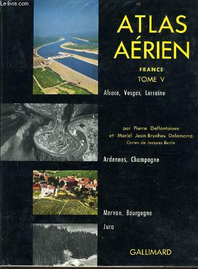
PIERRE DEFFONTAINES & MARIEL JEAN BRUNHES DELAMARR
ATLAS AERIEN FRANCE tome V : Alsace Vosges Lorraine, Ardennes et Champagne, Morvan et Bourgogne, Jura.
GALLIMARD. 1964. In-4. Relié toilé. Bon état, Couv. convenable, Dos satisfaisant, Intérieur frais. 94 pages. Nombreuses photographies en noir et blanc dans le texte et hors texte.. Avec Jaquette. . . Classification Dewey : 912-Atlas, cartes et plans
Bookseller reference : R240011302
|
|
|
Pierre Deffontaines et Mariel Jean-Brunhes Delamarre.
ATLAS AERIEN - TOME 1 - ALPES, VALEE DU RHONE, PROVENCE, CORSE
1955 GALLIMARD - NRF. 1955. In-8. Relié toilé. Bon état, 184 pages. Nombreuses photos
Bookseller reference : 12564
|
|
|
Pierre Deffontaines et Mariel Jean-Brunhes Delamarre.
ATLAS AERIEN - TOME 2 - bretagne, Val de Loire, sologne et berry, pays atlantiques entre loire et gironde
1955 GALLIMARD - NRF. 1956. In-8. Relié toilé. Bon état, 188 pages. Nombreuses photos, bel envoi autographe de Mariel Jean'Brunhes Delamarre
Bookseller reference : 12565
|
|
|
Pierre Deffontaines et Mariel Jean-Brunhes Delamarre.
ATLAS AERIEN - TOME 4 Paris et la vallée de la seine, ile de France, Beauce et Brie, Normandie , de la picardie a la flandre
1955 GALLIMARD - NRF. 1962. In-8. Relié toilé. Bon état, 188 pages. Nombreuses photos, bel envoi autographe de Mariel Jean'Brunhes Delamarre bel envoi autographe de Mariel Jean-Brunhes Delamarre.
Bookseller reference : 12566
|
|
|
Pierre George et Pierre Randet/Roland Nistri et Claude Prêcheur/André Blanc, Etienne Juilliard, Joanny Ray et Michel Rochefort/Jean Labasse et Michel Laferrère/Paul Carrère et Raymond Dugrand/Pierre Barrère et Roger Heisch/Pierre Flatres et Jacques
France de demain. 1. La région parisienne. 2. La région du nord et du nord-est. 3. Les régions de l'est. 4. La région lyonnaise. 5. La région méditerranéenne. 6. La région du sud-ouest. 7. La région de l'ouest. 8. La région du centre.
français (De 1959 à 1961). Ensemble complet de 8 volumes in-8 ; cartonnés de l'éditeur. Riche iconographie.
|
|
|
PIERRE GOUROU
ATLAS CLASSIQUE. FRANCE, UNION FRANCAISE.
HACHETTE. 1954. In-Folio. Cartonné. Etat d'usage, Coins frottés, Dos frotté, Intérieur frais. 68 pages de cartes illustrées en couleurs + 7 pages d'index.. . . . Classification Dewey : 912-Atlas, cartes et plans
Bookseller reference : R260110505
|
|
|
PIERRE GOUROU
NOUVEL ATLAS DU MONDE
Hachette. 1965. In-4. Broché. Etat d'usage, Coins frottés, Manque en coiffe de pied, Intérieur frais. 112 planches de cartes en couleurs; couverture cartonnée; coiffe de tête abîmée; rousseurs sur pages de garde.. . . . Classification Dewey : 912-Atlas, cartes et plans
Bookseller reference : RO30008280
|
|
|
PIERRE SERRYN
ATLAS BORDAS ECONOMIQUE ET POLITIQUE
BORDAS. 1990. In-Folio. Cartonné. Bon état, Couv. convenable, Dos satisfaisant, Intérieur frais. 71 pages illustrées en couleurs.. . . . Classification Dewey : 912-Atlas, cartes et plans
Bookseller reference : R200005631
|
|
|
Pierre SERRYN
ATLAS GEOGRAPHIQUE
Un ouvrage de 58 pages, format 245 x 325 mm, illustré de cartes, relié cartonnage couleurs, publié en 1985, bon état
Bookseller reference : LFA-126734061
|
|
|
PIERRE SERRYN
GRAND ATLAS BORDAS. GEOGRAPHIQUE / HISTORIQUE / POLITIQUE / ECONOMIQUE / STRATEGIQUE
BORDAS. non daté. In-4. Relié. Bon état, Couv. convenable, Dos satisfaisant, Intérieur frais. 216 + 40 + 31 + 71 pages. Nombreuses cartes en couleurs, hors texte.. Avec Jaquette. . . Classification Dewey : 912-Atlas, cartes et plans
Bookseller reference : RO20137807 ISBN : 2040153292

|
|
|
PIERRE SERRYN (SOUS LA DIRECTION DE)
GRAND ATLAS BORDAS. Géographique, astronomique, historique, politique, économique, stratégique.
BORDAS. 1988. In-4. Cartonnage d'éditeurs. Etat d'usage, Couv. légèrement passée, Dos abîmé, Mouillures. 224 pages + index environ 100 pages + 26 + 38 + 40 + 71 pages. Nombreuses cartes en couleurs hors texte. Photos en couleurs dans et hors texte. Manque au dos (rogné).. . . . Classification Dewey : 912-Atlas, cartes et plans
Bookseller reference : R260117012 ISBN : 2040168249
|
|
|
Pierre SERRYN et René BLASSELLE
NOUVEL ATLAS BORDAS
Un ouvrage de 162 pages, format 235 x 325 mm, illustré de cartes en couleurs, relié toile, publié en 1976, Bordas, bon état
Bookseller reference : LFA-126723645
|
|
|
Pierre VALLAUD, Mathilde AYCARD
ATLAS HISTORIQUE
Un ouvrage de 95 pages, format 235 x 290 mm, illustré, broché couverture couleurs, publié en 2000, bon état
Bookseller reference : LFA-126739528
|
|
|
PIERRE VIDAL NAQUET
ATLAS HISTORIQUE HISTOIRE DE L'HUMANITE DE LA PREHISTOIRE A NOS JOURS.
HACHETTE. 1987. In-4. Relié. Bon état, Couv. convenable, Dos satisfaisant, Intérieur frais. 339 pages - jaquette en bon état - nombreuses cartes et illustrations en couleurs dans le texte.. Avec Jaquette. . . Classification Dewey : 912-Atlas, cartes et plans
Bookseller reference : R240104296 ISBN : 2010110277
|
|
|
PIERRE VIDAL-NAQUET (SOUS LA DIRECTION DE)
ATLAS HISTORIQUE. HISTOIRE DE L'HUMANITE DE LA PREHISTOIRE A NOS JOURS.
HACHETTE. 1987. In-4. Cartonné. Bon état, Couv. convenable, Dos satisfaisant, Intérieur frais. 339 pages. Jaquette illustrée en couleurs. Nombreuses photos et cartes en couleurs et noir et blanc, dans et hors texte.. Avec Jaquette. . . Classification Dewey : 912-Atlas, cartes et plans
Bookseller reference : R260145831 ISBN : 2010110277
|
|
|
PIERRE, HACQ, FLAHAUT
Carte d'Abbeville. N°11
DEPOT DE LA GUERRE. 1902. In-Plano. En feuillets. Bon état, Livré sans Couverture, Dos satisfaisant, Intérieur frais. Carte dépliante en noir et blanc de 59 / 84 cm.. . . A l'italienne. Classification Dewey : 912-Atlas, cartes et plans
Bookseller reference : RO80072065
|
|
|
PIERRON / BLANCHARD / ERARD / BEAUPRE Fils
Carte de Toulouse S.-E.
SERVICE GEOGRAPHIQUE DE L'ARMEE. Non daté. In-Plano. En feuillets. Bon état, Couv. convenable, Dos satisfaisant, Intérieur frais. Carte dépliante en noir et blanc, hors-texte, de 75/53 cm. Pas de plats de couverture. Tampon.. . . A l'italienne. Classification Dewey : 912-Atlas, cartes et plans
Bookseller reference : RO80017189
|
|
|
PIERRON / BLANCHARD / REICHLING / CHARTIER
Carte de Privas (Sud-Est)
NON INDIQUE. 1890. In-Folio. En feuillets. Bon état, Couv. convenable, Dos satisfaisant, Intérieur bon état. Carte dépliante en noir et blanc, de 35/55 cm. Pas de plat de couverture.. . . . Classification Dewey : 912-Atlas, cartes et plans
Bookseller reference : RO20054729
|
|
|
PIERRON / REICHLING / HACQ / COSQUIN
Carte de L'Hospitalet (Sud-Est).
NON INDIQUE. 1900. In-Plano. En feuillets. Très bon état, Couv. convenable, Dos satisfaisant, Intérieur bon état. Carte dépliante en noir et blanc, de 52/74 cm. Pas de plat de couverture.. . . . Classification Dewey : 912-Atlas, cartes et plans
Bookseller reference : RO20054748
|
|
|
PIERRON, HACQ et BARRIERE
Carte de Mulhouse. N°101
DEPOT DE LA GUERRE. 1896. In-Plano. En feuillets. Etat d'usage, Livré sans Couverture, Dos satisfaisant, Pliures. Carte dépliante en noir et blanc de 59 / 84 cm. . . A l'italienne. Classification Dewey : 912-Atlas, cartes et plans
Bookseller reference : RO80072084
|
|
|
Pietsch, Roland & Pleticha, Heinrich [Hrsg.]
Sudetendeutscher Heimatatlas.
Braunschweig, Archiv-Verlag, ca. 2004. 34 cm, 92 Seiten, mit zahlreichen Illustrationen und Karten sowie einer beigelegten gefalteten Stadtansicht von Prag 1536, braunes Kunstleder, goldgeprägte Rücken- und Deckeltitel, Kopfgoldschnitt, Lesebändchen. Kapitale leicht berieben, gut bis sehr gut erhalten.
Bookseller reference : 26406AB
|
|
|
Pietsch, Roland und Heinrich Pleticha (Hrsg.)
Sudetendeutscher Heimatatlas. ERSTAUSGABE.
Braunschweig, Archiv Verlag, ohne Jahr. 92 Seiten. Mit zahlreichen farbigen Abbildungen. 31 cm Leberband
Bookseller reference : 305011

|
|
|
PILAT (Dr Albert).
Champignons - Atlas illustre. Illustrations d'apres les aquarelles de Otto USAK.
Paris, Grund ("Approches de la Nature"), 1971. in 12 161+ 94 planches hors-texte illustrees en couleurs, index, cartonnage illustré.
Bookseller reference : 42249

|
|
|
PILAT (Dr Albert).
Champignons - Atlas illustre. Illustrations d'apres les aquarelles de Otto USAK.
in 12 161+ 94 planches hors-texte illustrees en couleurs, index, cartonnage illustré. Bel exemplaire. [MI-28]
|
|
|
Pilat, Albert
Monographie des espèces européennes du genre Lentinus Fr. [Par Albert Pilat]. (= Atlas des Champignons de l'Europe, volume 5).
Prague (Prag): Josef Sefl 1946. 46 pages, 33 feuillets. 31 planches avec des illustrations en noir et blanc en annexe. Gr. 8° (22,5-25 cm) Orig.-Broschur mit Orig.-Schutzumschlag. [Softcover / Paperback].
Bookseller reference : 2137609

|
|
|
Pinardel (François)
Géographie-atlas. La France et l'Union française.
français In-4 de 244 pp.; cartonné de l'éditeur, dos toilé, premier plat illustré. Classe de troisième C. C. N° 363. Scotch au sommet du dos, transferts de scotch sur les contreplats.
|
|
|
Pinardel (François)
Petit atlas de la France et de l'Union française.
français Grand in-8 oblong de 32 pp.; cartonné souple avec agrafes.
|
|
|
Pinardel F.
L'Europe et l'Asie russe
Les éditions de l'école. Non daté. In-4. Broché. Etat d'usage, Tâchée, Dos satisfaisant, Intérieur frais. 40 pages de cartes en couleurs.. . . A l'italienne. Classification Dewey : 912-Atlas, cartes et plans
Bookseller reference : R200102526
|
|
|
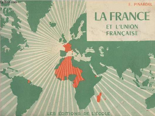
Pinardel F.
La France est l'Union française
Les éditions de l'école. Non daté. In-4. Broché. Etat d'usage, Couv. légèrement passée, Dos satisfaisant, Intérieur acceptable. 32 pages augmentées de nombreuses cartes en couleurs.2e plat légèrement déchiré. Non daté.. . . A l'italienne. Classification Dewey : 912-Atlas, cartes et plans
Bookseller reference : R240151083
|
|
|
PINARDEL F.
LA FRANCE ET LA COMMUNAUTE FRANCAISE - N°363 Bis.
LES EDITIONS DE L'ECOLE. NON DATE.. In-8. Broché. Bon état, Couv. convenable, Dos satisfaisant, Intérieur frais. 32 pages de cartes en couleur - 1er plat illustré en couleur.. . . A l'italienne. Classification Dewey : 912-Atlas, cartes et plans
Bookseller reference : RO20186820
|
|
|
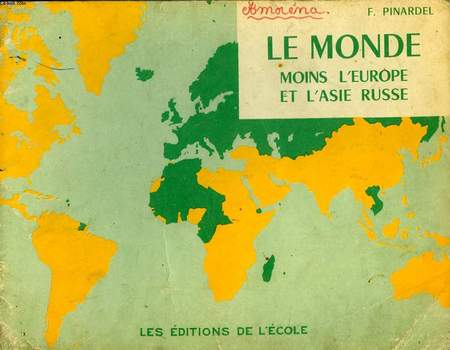
PINARDEL F.
LE MONDE MOINS L'EUROPE ET L'ASIE RUSSE
LES EDITIONS DE L'ECOLE. non daté. In-8. Broché. Etat d'usage, 1er plat abîmé, Dos frotté, Intérieur frais. 32 pages de cartes du monde en couleurs. Ecritures sur le premier palt.. . . A l'italienne. Classification Dewey : 912-Atlas, cartes et plans
Bookseller reference : RO30043064
|
|
|
PINARDEL F.
PETIT ATLAS DE LA FRANCE ET DE L'UNION FRANCAISE
L'Ecole. Non daté. In-4. Broché. Bon état, Couv. légèrement passée, Dos satisfaisant, Intérieur frais. 32 pages. Illustré de nombreuses cartes en couleur.. . . A l'italienne. Classification Dewey : 912-Atlas, cartes et plans
Bookseller reference : RO40223612
|
|
|
PINARDEL F.
PETIT ATLAS DE LA FRANCE ET DE L'UNION FRANCAISE
L'Ecole. Non daté. In-4 Carré à l'italienne. Broché. Bon état. Couv. légèrement passée. Dos satisfaisant. Intérieur frais. 32 pages. Illustré de nombreuses cartes en couleur. La France. Le Maroc. L'Algérie. La Tunisie. L'AOF...

|
|
|
PINARDEL FRANCOIS
GEOGRAPHIE / ATLAS - LA FRANCE ET LES PAYS D'OUTRE-MER D'EXPRESSION FRANCAISE - N°363
L'ECOLE. 1962. In-4. Relié. Etat passable, Coins frottés, Dos satisfaisant, Quelques rousseurs. 246 pages - Nombreuses photographies et cartes en noir et blanc, dans le texte - Annotations à l'encre sur la page de titre, étiquette sur la page de titre. . . . Classification Dewey : 912-Atlas, cartes et plans
Bookseller reference : R160199051
|
|
|
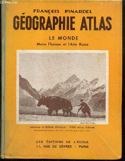
Pinardel François
Géographie Atlas - Le Monde, moins l'Europe et l'Asie Russe
Editions de l'Ecole. Non daté. In-4. Relié. Etat d'usage, Couv. convenable, Dos satisfaisant, Papier jauni. 194 pages. Nombreuses photos monochromes dans le texte. Nombreuses cartes monochromes et en couleurs dans et hors texte. Annotation au stylo en page de titre.. . . . Classification Dewey : 912-Atlas, cartes et plans
Bookseller reference : RO80259232
|
|
|
PINARDEL François
Géographie-Atlas. La France Métropolitaine et les Pays extra-métropolitains de l'Union France. Classe de Troisième Cours complémentaires.
DE L'ECOLE. 5ème édition. 1960. In-4. Cartonné. Etat d'usage, Couv. défraîchie, Dos satisfaisant, Intérieur acceptable. 246 pages. Nombreuses photos en noir et blanc, dans le texte. Nombreuses cartes en noir et blanc et en couleurs, dans le texte. Manque la page 15 / 16.. . . . Classification Dewey : 912-Atlas, cartes et plans
Bookseller reference : RO80147854
|
|
|
Pinardel, F. /
Geographie-Atlas. - 1) Pinardel, F.: Géog.-atlas. L'Amérique, L'Asie, L'Océanie, Les Pôles. Paris, éd. de l'École, 1962, / 2) Idem: Géog.-atlas. Classe de sixième. Cours Complémentaires. Idem, 1959, 117 p. / 3) Idem: L'Europe (moins la France) et l'Asie Russe. Classe de 4ème. 3e éd. Idem, 1962, 236 p.Ensemble de 3 Atlas.
1959- 1962, In-4°, 147 p. /117 p. / 236 p. reliures en demi-toile ill..
Bookseller reference : 19482aaf
|
|
|
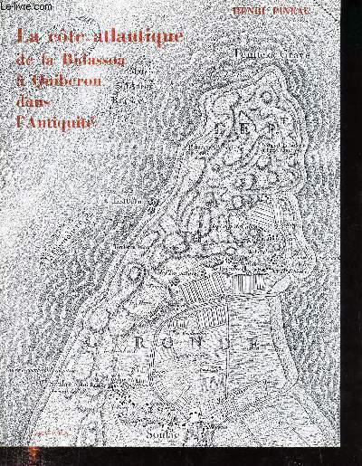
Pineau Henri
La côte atlantique de la Bidassoa a Quiberon dans l'antiquité
S.E.V.P.E.N.. 1970. In-8. Broché. Bon état, Couv. convenable, Dos satisfaisant, Intérieur frais. 92 pages augmentées de 13 pages de documents cartographiques en noir et blanc.. . . . Classification Dewey : 912-Atlas, cartes et plans
Bookseller reference : R200108462
|
|
|
Pinol Jean-Luc
Atlas historique des villes de France
Hachette Album cartonné avec jaquette 1991 In-4 (24,5 x 34,5 cm.), album cartonné sous jaquette, 318 pages, illustrations et documents couleurs et noir et blanc in-texte, villes de Paris / Rouen / Lille / Strasbourg / Lyon / Marseille / Montpellier / Toulouse / Bordeaux / Nantes, rare et importante étude ; jaquette un peu défraîchie, par ailleurs très bon état. Livraison a domicile (La Poste) ou en Mondial Relay sur simple demande.
Bookseller reference : bb3913
|
|
|
PINOL, Jean-Luc
Atlas historique des Villes de France
1 vol. in-4 cartonnage éditeur sous jaquette illustrée, Hachette, Paris, 1996
Bookseller reference : 65203

|
|
|
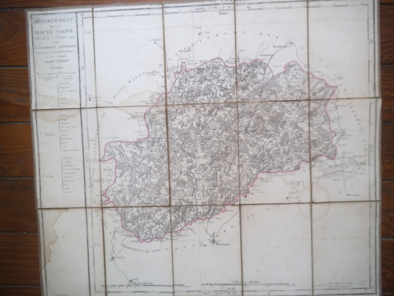
PIQUET Charles
Carte du département de la Haute Saône
Carte du département de la Haute Saône décrété le 5 février 1790 par l’Assemblée Nationale, divisé en 3 arrondissements et 27 cantons. 530x610mmm entoilée. Repliée 50x150mm (3 taches d’humidité) Charles PIQUET Géographe ordinaire du Roi, Atlas National de France.
Bookseller reference : 13353
|
|
|
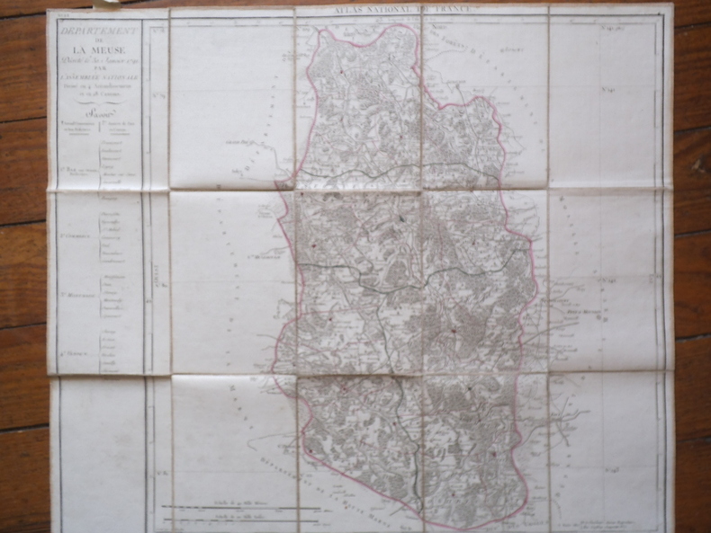
PIQUET Charles.
Carte du département de la Meuse
PIQUET Charles. Carte du département de la Meuse décrété le 30 janvier 1791 par l’Assemblée Nationale Divisé en 4 arrondissements et en 28 cantons. Carte n°28 610x530 entoilée, 115x180mm pliée. Charles PIQUET géographe ordinaire du Roi Atlas National de France. A Paris quai de Conti n°17. Très bon état.
Bookseller reference : 13342
|
|
|
PIQUET Charles.
Carte du département de la Moselle
Carte du département de la Moselle décrété le 30 janvier 1791 par l’Assemblée Nationale Divisé en 4 arrondissements et en 30 cantons. Carte n°35. 610x530 entoilée, 115x180mm pliée. Charles PIQUET géographe ordinaire du Roi Atlas National de France. A Paris quai de Conti n°17. Très bon état.
Bookseller reference : 13343

|
|
 Receive by email
 Download as PDF document
 RSS feed


