|
WOOLMAN AND ROSE ATLAS OF THE NEW JERSEY COAST
MANASQUAN: DR. ROBERT LAIRD RESIDENCE
1878. WOOLMAN AND ROSE ATLAS OF THE NEW JERSEY COAST. MANASQUAN 1878: DR. ROBERT LAIRD. A print showing the residence of Dr. Robert Laird in Squan. Squan is now known as Manasquan. $45.00. <br/><br/> unknown books
书商的参考编号 : 26203

|
|
|
WOOLMAN AND ROSE ATLAS OF THE NEW JERSEY COAST
MANASQUAN: DR. ROBERT LAIRD RESIDENCE
1878. WOOLMAN AND ROSE ATLAS OF THE NEW JERSEY COAST. MANASQUAN 1878: DR. ROBERTLAIRD. A hand-colored print showing the residence of Dr. Robert Laird in Squan. Squan is now known as Manasquan. $75.00. <br/><br/> unknown books
书商的参考编号 : 42881

|
|
|
WOOLMAN AND ROSE ATLAS OF THE NEW JERSEY COAST
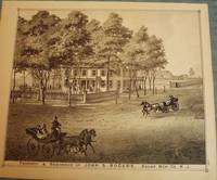
MANASQUAN: JOHN S. ROGERS RESIDENCE
1878. WOOLMAN AND ROSE ATLAS OF THE NEW JERSEY COAST. MANASQUAN 1878: JOHN S. ROGERS RESIDENCE. A print showing the property and residence of John S. Rogers in Squan. Squan is now known as Manasquan. $45.00. <br/><br/> unknown books
书商的参考编号 : 26213
|
|
|
WOOLMAN AND ROSE ATLAS OF THE NEW JERSEY COAST
MANASQUAN: JOHN S. ROGERS RESIDENCE
1878. WOOLMAN AND ROSE ATLAS OF THE NEW JERSEY COAST. MANASQUAN 1878: JOHN S. ROGERS RESIDENCE. An 11.5-inch by 14-inch hand-colored print showing the property and residence of John S. Rogers several strollers and three horse and buggy teams. Squan is now known as Manasquan. $85.00. <br/><br/> unknown books
书商的参考编号 : 33046

|
|
|
WOOLMAN AND ROSE ATLAS OF THE NEW JERSEY COAST
MANASQUAN: OSBORN HOUSE
1878. WOOLMAN AND ROSE ATLAS OF THE NEW JERSEY COAST. MANASQUAN 1878: OSBORN HOUSE. A print showing the Osborn House in Squan. Property of T. Fields. Squan is now known as Manasquan. $45.00. <br/><br/> unknown books
书商的参考编号 : 26210

|
|
|
WOOLMAN AND ROSE ATLAS OF THE NEW JERSEY COAST
MANASQUAN: OSBORN HOUSE
1878. WOOLMAN AND ROSE ATLAS OF THE NEW JERSEY COAST. MANASQUAN 1878: OSBORN HOUSE. A hand-colored print depicitng the Osborn House in Squan. Property of T. Fields. Squan is now known as Manasquan. $85.00. <br/><br/> unknown books
书商的参考编号 : 32576

|
|
|
WOOLMAN AND ROSE ATLAS OF THE NEW JERSEY COAST
MANASQUAN: OSBORNE CURTIS
1878. WOOLMAN AND ROSE ATLAS OF THE NEW JERSEY COAST. MANASQUAN VILLAGE 1878: ORBORNE CURTIS. A print showing the store property of Osborne Curtis in Squan Village. Squan Village is now known as Manasquan. $45.00. <br/><br/> unknown books
书商的参考编号 : 26212

|
|
|
WOOLMAN AND ROSE ATLAS OF THE NEW JERSEY COAST
MANASQUAN: UNION HOUSE
1878. WOOLMAN AND ROSE ATLAS OF THE NEW JERSEY COAST. MANASQUAN 1878: UNION HOUSE. A print showing a view of The Union House and its surroundings in Squan. Property of John M. Brown. Squan is now known as Manasquan. $45.00. <br/><br/> unknown books
书商的参考编号 : 26207

|
|
|
WOOLMAN AND ROSE ATLAS OF THE NEW JERSEY COAST
MAYS LANDING 1878 MAP
1878. WOOLMAN AND ROSE ATLAS OF THE NEW JERSEY COAST. MAYS LANDING MAP 1878. An 11-inch by 14-inch map of Mays Landing. $45.00. <br/><br/> unknown books
书商的参考编号 : 26658

|
|
|
WOOLMAN AND ROSE ATLAS OF THE NEW JERSEY COAST
MONMOUTH COUNTY: OCEANPORT/MANASQUAN/SEA CLIFF/WEST CREEK
1878. WOOLMAN AND ROSE ATLAS OF THE NEW JERSEY COAST. MONMOUTH COUNTY 1878. A print featuring four different panels. The farm & residence of J.B. Scholl West Creek The Park Hotel H.B. Edwards Oceanport Wills & Borton Sea Cliff Hot & Cold Sea Water Bathing Establishment in East Long Branch & the residence of Dr. A.A. Higgins in Squan Villa. $45.00. <br/><br/> unknown books
书商的参考编号 : 26260

|
|
|
WOOLMAN AND ROSE ATLAS OF THE NEW JERSEY COAST
OCEAN COUNTY: WEST CREEK CRANBERRY PLANTATION
1878. WOOLMAN AND ROSE ATLAS OF THE NEW JERSEY COAST. WEST CREEK CRANBERRY PLANTATION 1878. Print showing the Stafford Forge Cranberry Plantation West Creek Ocean County the property of Daniel R. Gowdy. Hand-colored. $100.00. <br/><br/> unknown books
书商的参考编号 : 26100

|
|
|
WOOLMAN AND ROSE ATLAS OF THE NEW JERSEY COAST
OCEAN GROVE: PARLORS OF THE ARLINGTON
1878. WOOLMAN AND ROSE ATLAS OF THE NEW JERSEY COAST. OCEAN GROVE: PARLORS OF THE ARLINGTON 1878. A hand-colored original 11.5-inch by 14-inch print showing the Parlors of the Arlington in Ocean Grove property of Charles E. Howland. $100.00. <br/><br/> unknown books
书商的参考编号 : 26194

|
|
|
WOOLMAN AND ROSE ATLAS OF THE NEW JERSEY COAST
POINT PLEASANT: ARNOLD HOUSE
1878. WOOLMAN AND ROSE ATLAS OF THE NEW JERSEY COAST. POINT PLEASANT 1878: ARNOLD HOUSE. An 11.5-inch by 14-inch print depicting a full view of the Arnold House and adjoining horse field owned by J. Arnold P'r. $45.00. <br/><br/> unknown books
书商的参考编号 : 26666

|
|
|
WOOLMAN AND ROSE ATLAS OF THE NEW JERSEY COAST
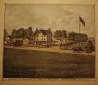
POINT PLEASANT: CHAS. W MAXSON RESIDENCE
1878. WOOLMAN AND ROSE ATLAS OF THE NEW JERSEY COAST. POINT PLEASANT 1878: CHAS. W. MAXSON RESIDENCE. An 11.5-inch by 14-inch engraving depicting the property and residence of Charles W. Maxson in Point Pleasant. $45.00. <br/><br/> unknown books
书商的参考编号 : 26664

|
|
|
WOOLMAN AND ROSE ATLAS OF THE NEW JERSEY COAST
POINT PLEASANT: CHAS. W. MAXSON RESIDENCE
1878. WOOLMAN AND ROSE ATLAS OF THE NEW JERSEY COAST. POINT PLEASANT: CHAS. W. MAXSON RESIDENCE. 1878. An 11.5-inch by 14-inch hand-colored engraving depicting the property and residence of Charles W. Maxson in Point Pleasant. $85.00. <br/><br/> unknown books
书商的参考编号 : 26517
|
|
|
WOOLMAN AND ROSE ATLAS OF THE NEW JERSEY COAST
POINT PLEASANT: OCEAN HOUSE
1878. WOOLMAN AND ROSE ATLAS OF THE NEW JERSEY COAST. POINT PLEASANT 1878: OCEAN HOUSE. An 11.5-inch by 14-inch print depicting a full view of the Ocean House in Pt. Pleasant Chas. W. Sutterley Pror. $45.00. <br/><br/> unknown books
书商的参考编号 : 26667

|
|
|
WOOLMAN AND ROSE ATLAS OF THE NEW JERSEY COAST
POINT PLEASANT: WHITE LAWN CEMETERY
1878. WOOLMAN AND ROSE ATLAS OF THE NEW JERSEY COAST. POINT PLEASANT 1878 CEMETERY MAP. A 14-inch by 11-inch map of the plan of the White Lawn Cemetery in Point Pleasant. $10.00. <br/><br/> unknown books
书商的参考编号 : 26215

|
|
|
WOOLMAN AND ROSE ATLAS OF THE NEW JERSEY COAST
POINT PLEASANT: WM. CURTIS RESIDENCE
1878. WOOLMAN AND ROSE ATLAS OF THE NEW JERSEY COAST. POINT PLEASANT 1878: WM. CURTIS RESIDENCE. An 11.5-inch by 14-inch engraving depicting a full view of the property and residence of William Curtis in Point Pleasant. $45.00. <br/><br/> unknown books
书商的参考编号 : 26665

|
|
|
WOOLMAN AND ROSE ATLAS OF THE NEW JERSEY COAST
POINT PLEASANT: WM. CURTIS RESIDENCE
1878. WOOLMAN AND ROSE ATLAS OF THE NEW JERSEY COAST. POINT PLEASANT 1878: WM. CURTIS RESIDENCE. An 11.5-inch by 14-inch hand-colored engraving depicting a full view of the property and residence of William Curtis in Point Pleasant. $85.00. <br/><br/> unknown books
书商的参考编号 : 26515

|
|
|
WOOLMAN AND ROSE ATLAS OF THE NEW JERSEY COAST
RUMSON: J.P. COOPER RESIDENCE
1878. WOOLMAN AND ROSE ATLAS OF THE NEW JERSEY COAST. RUMSON 1878: J.P. COOPER RESIDENCE. Frontal view of the residence of J.P. Cooper Rumson. $45.00. <br/><br/> unknown books
书商的参考编号 : 26053

|
|
|
WOOLMAN AND ROSE ATLAS OF THE NEW JERSEY COAST
SPRING LAKE 1878 MAP
1878. WOOLMAN AND ROSE ATLAS OF THE NEW JERSEY COAST. SPRING LAKE 1878 MAP. A 14-inch by 22-inch hand-colored map showing the Spring Lake Beach Tract Reid's Villa Park adjoining Sea Girt. $65.00. <br/><br/> unknown books
书商的参考编号 : 26099

|
|
|
WOOLMAN AND ROSE ATLAS OF THE NEW JERSEY COAST
SPRING LAKE HEIGHTS: 1878 MAP
1878. WOOLMAN AND ROSE ATLAS OF THE NEW JERSEY COAST. SPRING LAKE HEIGHTS 1878 MAP. A 14-inch by 22-inch map showing Rodger's Park adjoining Spring Lake. $60.00. <br/><br/> unknown books
书商的参考编号 : 26087

|
|
|
WOOLMAN AND ROSE ATLAS OF THE NEW JERSEY COAST
SPRING LAKE: REID VILLA PARK
1878. WOOLMAN AND ROSE ATLAS OF THE NEW JERSEY COAST. SPRING LAKE: REID VILLA PARK 1878. Showing a side-view of the property of Wm. V. Reid. $45.00. <br/><br/> unknown books
书商的参考编号 : 26069

|
|
|
WOOLMAN AND ROSE ATLAS OF THE NEW JERSEY COAST
SPRING LAKE: VILLA PARK
1878. WOOLMAN AND ROSE ATLAS OF THE NEW JERSEY COAST. SPRING LAKE: REID VILLA PARK 1878. An 11.5-inch by 14-inch hand-colored print showing a side-view of the property of Wm. V. Reid people in period dress and a horse and buggy. $100.00. <br/><br/> unknown books
书商的参考编号 : 29304

|
|
|
WOOLMAN AND ROSE ATLAS OF THE NEW JERSEY COAST
TOMS RIVER: JAMES GOWDY RESIDENCE
1878. WOOLMAN AND ROSE ATLAS OF THE NEW JERSEY COAST. TOMS RIVER 1878: JAMES GOWDY RESIDENCE. An 11.5-inch by 14-inch print depicting the residence of James G. Gowdy and its surroundings Toms River. $45.00. <br/><br/> unknown books
书商的参考编号 : 26685

|
|
|
WOOLMAN AND ROSE ATLAS OF THE NEW JERSEY COAST
TUCKAHOE MAP 1878
1878. WOOLMAN AND ROSE ATLAS OF THE NEW JERSEY COAST. TUCKAHOE MAP 1878. An 11-inch by 14-inch hand-colored map depicting North & South Tuckahoe. $45.00. <br/><br/> unknown books
书商的参考编号 : 26660

|
|
|
WOOLMAN AND ROSE ATLAS OF THE NEW JERSEY COAST
WALL TOWNSHIP: BRIGHTON LAND ASSOCIATION: 1878 MAP
1878. WOOLMAN AND ROSE ATLAS OF THE NEW JERSEY COAST. WALL TOWNSHIP BRIGHTON LAND ASSOCIATION: 1878 MAP. A 14-inch by 22-inch map showing the Brighton Land Association situated in Wall Township adjoining Spring Lake. Also showing a smaller map of central & southern New Jersey. $65.00. <br/><br/> unknown books
书商的参考编号 : 26098

|
|
|
WOOLMAN AND ROSE ATLAS OF THE NEW JERSEY COAST
WARETOWN MAP 1878
1878. WOOLMAN AND ROSE ATLAS OF THE NEW JERSEY COAST. WARETOWN MAP 1878. AN 11-inch by 14-inch map of Waretown. $45.00. <br/><br/> unknown books
书商的参考编号 : 26662

|
|
|
WOOLMAN AND ROSE ATLAS OF THE NEW JERSEY COAST
WEST CREEK MAP 1878
1878. WOOLMAN AND ROSE ATLAS OF THE NEW JERSEY COAST. WEST CREEK MAP 1878. AN 11-inch by 14-inch map of West Creek. $45.00. <br/><br/> unknown books
书商的参考编号 : 26663

|
|
|
Worcester's Atlas
Worcester's Ancient Classical and Scripture Atlas: Containing the Following Maps:.Improved Edition
Boston & Paris: David H. Williams 1839. 10 maps some with several to the sheet; with handcolored maps including: Roman Empire; Italy; Greece; Asia Minor; The World exhibiting the Countries mentioned in the Old Testament; Journeyings of the Israelites from Egypt to Canaan; Judah and Israel with the Division of the Twelve Tribes; Palestine or the Holy Land; Ancient Jerusalem with its Environs; Map Illustrative of the Travels of St. Paul; approx. 9 1/2" x 11 1/2" size; yellow printed paper coverd paper stock binding; covers very worn chipped & stained; maps are on a softer paper; detached from the binding and occasionally foxed some edgewear; overall maps in good condition and an interesting early American Christian religion & education atlas. Improved Edition. Soft Cover. Good. David H. Williams Paperback
书商的参考编号 : 17778

|
|
|
Worcester's Atlas
Worcester's Ancient Classical and Scripture Atlas: Containing the Following Maps:.Improved Edition
Boston & Paris: David H. Williams 1839. 10 maps some with several to the sheet; with handcolored maps including: Roman Empire; Italy; Greece; Asia Minor; The World exhibiting the Countries mentioned in the Old Testament; Journeyings of the Israelites from Egypt to Canaan; Judah and Israel with the Division of the Twelve Tribes; Palestine or the Holy Land; Ancient Jerusalem with its Environs; Map Illustrative of the Travels of St. Paul; approx. 9 1/2" x 11 1/2" size; yellow printed paper coverd paper stock binding; covers very worn chipped & stained; maps are on a softer paper; detached from the binding and occasionally foxed some edgewear; overall maps in good condition and an interesting early American Christian religion & education atlas. Improved Edition. Soft Cover. Good. David H. Williams Paperback books
书商的参考编号 : 17778
|
|
|
WORLD ATLAS Guthrie William; James Ferguson.
A New Geographical Historical and Commercial Grammar and Present State of the Several Kingdoms of the World. William Guthrie Esq. The Astronomical Part by James Ferguson F.R.S.
London.: J. Mawman Succesor to Mr. Dilly in the Poultry. 18th Edition. 1800. Massive tome 8 1/2 x 5 1/4 inches 1054 pages 1055-56 missing. "Illustrated with A Correct Set of Maps." There are 27 folded maps the bulk approximately 8 1/2 x 9 1/2 inches. There is also a one-page illustrated plate titled "The Armillary Sphere" a model of the celestial globe. Front and rear cover to the volume are missing. The maps for the most part have the term "from the Best Authorities" following the title. In the list below maps larger than the size given above will be identified with appropriate dimensions. The maps are well-preserved in good clean condition overall some with gentle time-toning. Five panel Map of the World 8 1/2 x 15 1/2 inches; Chart of the World on Mercators Projection; Europe from the Best Authorities; Sweden Denmark Norway Finland; Northern Part of Russia or Muscovy in Europe; Southern Part of Muscovy in Europe; Scotland; England and Wales; Ireland; France divided into Military Governments; France divided into Circles and Departments; The Seven United Provinces; Netherlands; Germany; Poland; Switzerland with its Subjects and Allies; Spain and Portugal; Italy; Turkey in Europe and Hungary; Asia; Hindostan or India; Africa; A General Map of North America; British Colonies in North America; The United States of America According to the Treaty of Peace of 1784; West Indies 8 1/2 x 13 1/4 inches; South America. Full author list: William Guthrie Esq. The Astronomical Part by James Ferguson F.R.S. To which have been added the Late Discoveries of Dr. Herschel and other Eminent Astronomers. . J. Mawman (Succesor to Mr. Dilly) in the Poultry. unknown
书商的参考编号 : 55115

|
|
|
WORLD ATLAS 1800 Walker John; revised and enlarged byArthur Kershaw.
The Universal Gazetteer. ENGRAVED MAPS
London.: Vernor and Hood et al. 3rd Edition. 1801. Volume 8 1/4 x 5 inches half-leather binding unpaginated but fully two inches thick. Entries alphabetized from AAK rivers to ZYTOMIERZ a town. Title page calls for fourteen folding maps; all are present. The map of the world preceding the title page has been badly folded resulting in extra creases and has a small infill repair scarcely noticeable and small area of foxing; occasional light foxing but the other thirteen maps approximately 8 1/4 x 10 inches each are in overall good condition. In order of their placement in the volume these maps are: Africa North America South America Asia England and Wales Europe France Germany Hindoostan or India awkwardly folded West Indies 8 1/4 x 14 Ireland Scotland Spain and Portugal. At the bottom of the title page following the words "Printed for." nineteen individual entities are listed. . Vernor and Hood, et al. hardcover
书商的参考编号 : 55197

|
|
|
World Reader's Digest Children's Atlas of the
THE READER'S DIGEST NOTEBOOK ATLAS
Reader's Digest. Paperback. B002HTODM8 . New. 2003-01-01. Reader's Digest paperback
书商的参考编号 : 000071696
|
|
|
WORLD ATLAS Cram George F.
Cram's Unrivaled Family Atlas of the World.
Chicago.: Henry S. Stebbins. Copyright 1882. Color maps both hand colored and printed black and white illustrations decorative endpapers 122pp 14 x 12 inches decorative gilt lettered cloth covered boards hardbound. Front cover detached rear hinge starting to split but still attached covers soiled and rubbed exposing edges of boards front free endpaper loose slight insect damage to right margin of title page short tear to lower left edge of first few pages toning to Table of Contents page from newspaper article adhered to verso of title page occasional soiling to outer margins of some pages not affecting image areas. There is a tear to the lower centrefold of two maps: Alabama etc and the map of Dakota and Manitoba. Overall a well preserved copy of a scarce volume. This is an interesting transitional atlas from the heyday of the atlas with handcolored plates to the printed color atlas. The maps appear to have been printed with the wax engraved process with the resulting loss of clarity compared to the engraved atlases of the earlier nineteenth century but the handcolored maps of the states are decorative and detailed. These each with decorative oval cartouche title are titled "New Railroad and County Map." of: New York; Pennsylvannia New Jersey Delaware & Maryland; Virginia & West Virginia; North Carolina; Alabama Georgia Sth. Carolina & Northern Florida; Arkansas Louisiana & Mississippi interestingly there is a single page printed color map of Florida on the verso of this double page map; Indian Territory and Northern Part of Texas; Southern Part of Texs sic with inset of Western Part of Texas; Kentucky & Tennessee; Michigan & Wisconsin; Missouri; Kansas; Nebraska; Colorado; Minnesota; Dakota and Manitoba; Wyoming; Montana and Northern Idaho; Utah; Southern Part of Idaho; Oregon and Washington Territory; New Mexico; Northern California and Nevada; Alaska; Southern California and Arizona. Other maps are printed color. All double page maps are tipped in; most of the maps are double sided. There are also illustrations of Flags of All Nations Animal and Vegetable Life of the Different Zones Races of Man a map of the Solar System statistics on Comparative Wealth of States Population & Area information plus portraits of U.S. Presidents. . Henry S. Stebbins. hardcover
书商的参考编号 : 41610

|
|
|
WORLD ATLAS ORIGINAL HANDCOLOR
Fenner's Pocket Atlas of Modern and Ancient Geography.
London.: Robert Jennings. 1828. A self-identified "Pocket" Atlas 6 3/4 x 5 1/2 inches featuring 71 exquisitely hand-colored and highly detailed maps almost all in very good clean condition. Those of antiquity identified as "Classical" are 26 in number while 45 maps reflect contemporary cartography. Most maps measure approximately 6 1/2 x 5 1/4 inches although there are eight exceptions involving larger folding maps. These vary in size from 6 1/4 x 11 inches to 7 1/4 x 11 inches. The eight over-sized folding maps are identified with double numerals i.e. "20/21" on the contents page. They are titled "Eastern & Western Hemispheres" "Northern and Southern Polar Regions" "The World" "Central States of Europe as Settled by Congress in 1815" "Ottoman Empire" "Chinese Empire" "Canada New Brunswick & Nova Scotia" and "United States." A colorful folding chart titled "Principal Mountains & Principal Rivers" completes the volume. The hand-coloring is extremely delicate and the maps throughout demonstrate enormous attention to detail. The front cover and the free endpaper have come loose from the text block which is cracked but intact. The spine of volume has top to bottom vertical crack and loss at head; one of the oversize maps although clean and bright has been clumsily folded. The contents are a cartographic gem a beautifully engraved and handcolored depiction of the world as seen by European eyes 200 years ago. . Robert Jennings. unknown
书商的参考编号 : 55200

|
|
|
World Atlas
HISTORICAL HAND-ATLAS
Chicago and Toledo: H.H. Hardesty & Co 1882. Hard Cover. Small Folio. Illustrated containing large scale copper plate maps of each state and territory of the United States and the provinces of Canada together with a complete reference map of the world topographical and railroad map of the United States thirteen comprehensive maps of Bible geography covering all the countries of Bible history with classified pronunciative index of each map printed in colors from plates secured by letters patent producing the clearest typographical effect of any known engraved plates accompanied by a general survey of the world history of the United States-History of each state and territory of the United States outline map and history of Lawrence County Ohio. Containing a condensed history of the County; Biographical sketches; general statistics; miscellaneous matters etc. Frontispiece depicts Geysers in the Yellowstone Valley 60 of 61maps present lacking #44 &45 which is the United States the five folding maps are on stubs and printed on a much thinner paper with the map of New York laid in closed tear on map #164 small loss at lower edge of map #165. Re-backed and cornered in brown leather retaining original gilt stamped brown cloth endpapers renewed. A very good copy with excellent maps. <br/><br/> H.H. Hardesty & Co hardcover
书商的参考编号 : 6274

|
|
|
WORLD ATLAS
RAND MCNALLY WORLD ATLAS
RAND MCNALLY 1953 1953-01-01. Hardcover. Very Good. RAND MCNALLY 1953 hardcover
书商的参考编号 : 181212027
|
|
|
World Atlas
The Signet World Atlas: Completely Revised and Updated
Signet 1998-08-01. Revised. Mass Market Paperback. Used:Good. Signet paperback
书商的参考编号 : DADAX0451197321 ???????? : 0451197321 9780451197320

|
|
|
World Atlas Hammond Incorporated Incorporated
World Atlas Hammond
New. slight shelf wear pb unknown
书商的参考编号 : SKU1006131 ???????? : 0843724994 9780843724998
|
|
|
World Atlas
HISTORICAL HAND-ATLAS
Chicago and Toledo: H.H. Hardesty & Co 1882. Hard Cover. Small Folio. Illustrated containing large scale copper plate maps of each state and territory of the United States and the provinces of Canada together with a complete reference map of the world topographical and railroad map of the United States thirteen comprehensive maps of Bible geography covering all the countries of Bible history with classified pronunciative index of each map printed in colors from plates secured by letters patent producing the clearest typographical effect of any known engraved plates accompanied by a general survey of the world history of the United States-History of each state and territory of the United States outline map and history of Lawrence County Ohio. Containing a condensed history of the County; Biographical sketches; general statistics; miscellaneous matters etc. Frontispiece depicts Geysers in the Yellowstone Valley 60 of 61maps present lacking #44 &45 which is the United States the five folding maps are on stubs and printed on a much thinner paper with the map of New York laid in closed tear on map #164 small loss at lower edge of map #165. Re-backed and cornered in brown leather retaining original gilt stamped brown cloth endpapers renewed. A very good copy with excellent maps. <br/><br/> H.H. Hardesty & Co hardcover books
书商的参考编号 : 6274
|
|
|
World War I Atlas: Cram Company George F. publisher
UNITED STATES AT WAR AMERICAN WAR ATLAS . wrapper title
Chicago: George F. Cram Company 1918. 16pp. Folio 38 x 29 cm. Pictorial self-wrapper. Minute tear at fore-edge of first two leaves some neat annotations in colored pen in margins of three maps otherwise an unusually nice copy of a very fragile item. "Corrected and Revised Edition" including maps of the world with shipping routes Europe the Western Theatre Eastern Europe Russia Germany Italy Turkey and the US showing training camps all with details relevant to the war at that point. George F. Cram Company unknown
书商的参考编号 : WRCLIT79134

|
|
|
World War I Atlas: Cram Company George F. publisher
UNITED STATES AT WAR AMERICAN WAR ATLAS . wrapper title
Chicago: George F. Cram Company 1918. 16pp. Folio 38 x 29 cm. Pictorial self-wrapper. Minute tear at fore-edge of first two leaves some neat annotations in colored pen in margins of three maps otherwise an unusually nice copy of a very fragile item. "Corrected and Revised Edition" including maps of the world with shipping routes Europe the Western Theatre Eastern Europe Russia Germany Italy Turkey and the US showing training camps all with details relevant to the war at that point. George F. Cram Company unknown books
书商的参考编号 : WRCLIT79134
|
|
|
WorldSat International Inc
Spotlight Erde - Der Satelliten-Weltatlas,
Gütersloh, Bertelsmann (= Bertelsmann Lexikon), 2011. 4°, 288 S. , mit zahlreichen ganzseitigen Farbabbildungen, farbig illustr. original Pappband (Hardcover), Erstausgabe Zustand wie frisch aus der Buchhandlung.
书商的参考编号 : 10804BB

|
|
|
Wotte, Herbert und Siegfried Hoyer
TOURIST Stadtführer-Atlas Dresden
Berlin, Leipzig, VEB Tourist Verlag, 1979. 176 Seiten , 19 cm, Hardcover/Pappeinband
书商的参考编号 : 32861

|
|
|
WRIGHT JILL ET DAVID.
ATLAS DE POCHE.
ISBN : 2724222601. GP. 1984. In-12 Carré. Cartonnage d'éditeurs. Bon état. Couv. convenable. Dos satisfaisant. Intérieur frais. 189 pages. Nombreuses illustrations en noir et blanc et en couleurs dans le texte et hors texte. Traduction de ODILE RICKLIN.

|
|
|
WUHRER / GAY
Carte du Vicariat Apostolique de la Mongolie.
LES MISSIONS CATHOLIQUES. 15 oct. 1875. In-4. En feuillets. Bon état, Couv. convenable, Dos satisfaisant, Intérieur frais. Carte en noir et blanc de 44/30 cm. Pas de plats de couverture.. . . . Classification Dewey : 912-Atlas, cartes et plans
书商的参考编号 : RO80006286
|
|
|
WUHRER / GAY
Carte partielle du Royaume d'Annam (Tong-King) 1874
LES MISSIONS CATHOLIQUES. 1874. In-Folio. En feuillets. Etat d'usage, Couv. convenable, Dos satisfaisant, Intérieur frais. Carte en noir et blanc, de 44/30 cm. Trait au feutre rouge. Pas de plats de couverture.. . . . Classification Dewey : 912-Atlas, cartes et plans
书商的参考编号 : RO80006284
|
|
|
Wurzer, Rudolf (Hrsg.)
Strukturanalyse des österreichischen Bundesgebietes. Kartenband. (= Sonderausgabe im Rahmen der Schriftenreihe der Österreichischen Gesellschaft für Raumforschung und Raumplanung)
Wien, Österreichische Gesellschaft für Raumforschung und Raumplanung 1970. 4°. [ca. 250] Bl.. u. 4 gefaltete Beilagen, OPpbd., ausgeschied. Bibl.-Ex. mit den üblichen Kennzeichnungen, sehr gut erhalten.
书商的参考编号 : AUST2353
|
|
|
Wustmann, Gustav Dr
Leipzig durch drei Jahrhunderte
Leipzig, Duncker und Humblot, 1891. Gr. Folio (41x29cm), 6 nn. S., VIII, 24 S., 69 teils ausfaltbare Karten und Stahlstiche, Ganzleineneinband
书商的参考编号 : 7-3-626

|
|
 ?????????
 ?????PDF???
 RSS feed


