|
WOOD MARION
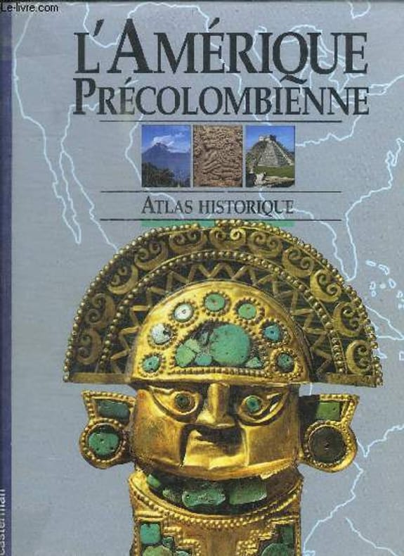
L'AMERIQUE PRECOLOMBIENNE - ATLAS HISTORIQUE
CASTERMAN. 1991. In-4. Relié. Bon état, Couv. convenable, Dos satisfaisant, Intérieur frais. 96 pages. Nombreuses illustrations en couleur dans et hors texte.. . . . Classification Dewey : 912-Atlas, cartes et plans
Bookseller reference : RO30133676
|
|
|
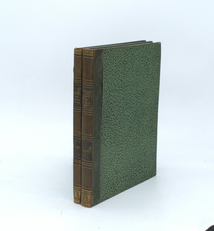
WOOD (Nicholson)
Traité pratique des chemins de fer, traduit de l'ouvrage anglais (deuxième édition). Avec des notes et additions par F. de Montricher et E. de Franqueville, et H. de Ruolz.
Paris, Carillan-Goeury, 1834, 2 volumes in-4, XII-306pp.-1f, titre et 14 planches sur 2 pages, relié demi veau époque , dos lisse avec auteur , titre et tomaison, frottements aux dos , début de fentes à l’atlas, manque de matière, un planche déchirée sans manque.
Bookseller reference : PHO-1478
|
|
|
WOOLMAN AND ROSE ATLAS OF THE NEW JERSEY COAST
ASBURY PARK: GRAND AVENUE HOUSE
1878. WOOLMAN AND ROSE ATLAS OF THE NEW JERSEY COAST. ASBURY PARK 1878. THE GRAND AVENUE HOUSE. An 11.5-inch by 14-inch hand-colored print showing the Grand Avenue House Property of Sill & Ripley in Asbury Park. $125.00. <br/><br/> unknown
Bookseller reference : 31435

|
|
|
WOOLMAN AND ROSE ATLAS OF THE NEW JERSEY COAST
ASBURY PARK: PRINCETON LUMBER YARD
1878. WOOLMAN AND ROSE ATLAS OF THE NEW JERSEY COAST. ASBURY PARK 1878. An original print not a reproduction showing the Branch yard of Princeton Lumber and Improvement Co. Hand-colored. $85.00. <br/><br/> unknown
Bookseller reference : 26179

|
|
|
WOOLMAN AND ROSE ATLAS OF THE NEW JERSEY COAST
ASBURY PARK: COLEMAN HOUSE
1878. WOOLMAN AND ROSE ATLAS OF THE NEW JERSEY COAST. ASBURY PARK 1878. THE COLEMAN HOUSE. An 11.5-inch by 14-inch hand-colored engraving depicting the Coleman House hotel and its surroundings in Asbury Park including boating on Wesley Lake. $125.00. <br/><br/> unknown
Bookseller reference : 27484

|
|
|
WOOLMAN AND ROSE ATLAS OF THE NEW JERSEY COAST
ATLANTIC CITY: COLONNADE HOUSE
1878. WOOLMAN AND ROSE ATLAS OF THE NEW JERSEY COAST. ATLANTIC CITY 1878. COLONNADE HOUSE. An 11.5-inch by 14-inch print of the Colonnade House in Atlantic City J. Henry Hayes Propr. $45.00. <br/><br/> unknown
Bookseller reference : 26671

|
|
|
WOOLMAN AND ROSE ATLAS OF THE NEW JERSEY COAST
ATLANTIC CITY: GERMANTOWN COTTAGE
1878. WOOLMAN AND ROSE ATLAS OF THE NEW JERSEY COAST. ATLANTIC CITY 1878. GERMANTOWN COTTAGE. An 11.5-inch by 14-inch print depicting a view of the Germantown Cottage Atlantic City J.W. Donnelly Prop. $45.00. <br/><br/> unknown
Bookseller reference : 26670

|
|
|
WOOLMAN AND ROSE ATLAS OF THE NEW JERSEY COAST
ATLANTIC CITY: HADDON HOUSE
1878. WOOLMAN AND ROSE ATLAS OF THE NEW JERSEY COAST. ATLANTIC CITY 1878. HADDON HOUSE. An 11.5-inch by 14-inch print which is devided into three sections. The upper section depicts a view of the Haddon House Lippincott & Stokes Propr's foot of N. Carolina Ave Atlantic City. The lower half depicts the Cottage Residence of Robt. Kaughn Atlantic City & the Residence of Eliza P. Gurney in Atlantic City. $45.00. <br/><br/> unknown
Bookseller reference : 26669

|
|
|
WOOLMAN AND ROSE ATLAS OF THE NEW JERSEY COAST
ATLANTIC CITY: SEA SIDE HOUSE
1878. WOOLMAN AND ROSE ATLAS OF THE NEW JERSEY COAST. ATLANTIC CITY SEADISE HOUSE 1878. An 11.5-inch by 14-inch print with the bottom half depicting a frontal view of the Sea Side House Atlantic City Chas. Evans Pror. The top half of the print is devoted to the Mongrief House in Jacksonville Florida. $45.00. <br/><br/> unknown
Bookseller reference : 26668

|
|
|
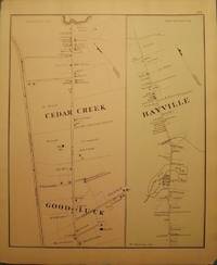
WOOLMAN AND ROSE ATLAS OF THE NEW JERSEY COAST
BAYVILLE
1878. WOOLMAN AND ROSE ATLAS OF THE NEW JERSEY COAST. BAYVILLE 1878. An 11-inch by 14-inch hand-colored map showing parts of Bayville Cedar Creek and Good Luck. $45.00. <br/><br/> unknown
Bookseller reference : 26652
|
|
|
WOOLMAN AND ROSE ATLAS OF THE NEW JERSEY COAST
BELMAR/ OCEAN BEACH: COLUMBIA HOUSE
1878. WOOLMAN AND ROSE ATLAS OF THE NEW JERSEY COAST. BELMAR/ OCEAN BEACH: COLUMBIA HOUSE 1878. A print showing the Columbia House in Ocean Beach. Ocean Beach is now known as Belmar. $50.00. <br/><br/> unknown
Bookseller reference : 26198

|
|
|
WOOLMAN AND ROSE ATLAS OF THE NEW JERSEY COAST
BELMAR/ OCEAN BEACH: FIFTH AVENUE HOUSE
1878. WOOLMAN AND ROSE ATLAS OF THE NEW JERSEY COAST. BELMAR/ OCEAN BEACH 1878. A print showing the 5th Avenue House in Ocean Beach. Property of J.L.Hoppock. Ocean Beach is now known as Belmar. $45.00. <br/><br/> unknown
Bookseller reference : 26196

|
|
|
WOOLMAN AND ROSE ATLAS OF THE NEW JERSEY COAST
BELMAR/ OCEAN BEACH: COLUMBIA HOUSE
1878. WOOLMAN AND ROSE ATLAS OF THE NEW JERSEY COAST. BELMAR/ OCEAN BEACH 1878. COLUMBIA HOUSE. An 11-inch by 14-inch hand-colored print showing the Columbia House a number of bathers and pedestrians and several horse and buggy or wagon teams. Ocean Beach is now known as Belmar. $100.00. <br/><br/> unknown
Bookseller reference : 29302

|
|
|
WOOLMAN AND ROSE ATLAS OF THE NEW JERSEY COAST
BELMAR/ OCEAN BEACH: NEPTUNE HOUSE
1878. WOOLMAN AND ROSE ATLAS OF THE NEW JERSEY COAST. BELMAR/ OCEAN BEACH 1878. NEPTUNE HOUSE. A print of the Neptune House in Ocean Beach. Property of J.L. Hoppock. Ocean Beach is now known as Belmar. $45.00. <br/><br/> unknown
Bookseller reference : 26199

|
|
|
WOOLMAN AND ROSE ATLAS OF THE NEW JERSEY COAST
BELMAR/ OCEAN BEACH: NEPTUNE HOUSE
1878. WOOLMAN AND ROSE ATLAS OF THE NEW JERSEY COAST. BELMAR/ OCEAN BEACH 1878. NEPTUNE HOUSE. An 11.5-inch by 14-inch hand-colored print of the Neptune House in Ocean Beach. Property of J.L. Hoppock. Ocean Beach is now known as Belmar. $85.00. <br/><br/> unknown
Bookseller reference : 31433

|
|
|
WOOLMAN AND ROSE ATLAS OF THE NEW JERSEY COAST
BELMAR/ RED BANK
1878. WOOLMAN AND ROSE ATLAS OF THE NEW JERSEY COAST. BELMAR/ RED BANK. 1878. A print divided in two halfs top showing the Store & Residence of D.A. Walling in Ocean Beach now known as Belmar bottom is of the Greenhouses at the Oak Hill Nurseries E.T. Field Red Bank. $45.00. <br/><br/> unknown
Bookseller reference : 26256

|
|
|
WOOLMAN AND ROSE ATLAS OF THE NEW JERSEY COAST
BELMAR/ RED BANK
1878. WOOLMAN AND ROSE ATLAS OF THE NEW JERSEY COAST. OCEAN BEACH BELMAR/ RED BANK 1878. An 11.5-inch by 14-inch hand-colored engraving depicting "Store & Residence of D.A. Walling Ocean Beach NJ now known as Belmar and "Greenhouses at Oak Hill Nurseries E.T. Field Red Bank." $75.00. <br/><br/> unknown
Bookseller reference : 27487

|
|
|
WOOLMAN AND ROSE ATLAS OF THE NEW JERSEY COAST
BRICKSBURG
1878. WOOLMAN AND ROSE ATLAS OF THE NEW JERSEY COAST. BRICKSBURG 1878. An 11-inch by 14-inch map of Bricksburg. $45.00. <br/><br/> unknown
Bookseller reference : 26653

|
|
|
WOOLMAN AND ROSE ATLAS OF THE NEW JERSEY COAST
CAPE MAY COURT HOUSE: W.E. RAYMOND MARBLE WORKS
1878. WOOLMAN AND ROSE ATLAS OF THE NEW JERSEY COAST. CAPE MAY COURT HOUSE 1878. W.E. RAYMOND MARBLE WORKS. An 11.5-inch by 14-inch print depicting a frontal view of the Marble Works of W.E. Raymond Cape May Court House. $45.00. <br/><br/> unknown
Bookseller reference : 26678

|
|
|
WOOLMAN AND ROSE ATLAS OF THE NEW JERSEY COAST
CAPE MAY POINT: JOHN WANAMAKER COTTAGE/ SEA GROVE HOUSE
1878. WOOLMAN AND ROSE ATLAS OF THE NEW JERSEY COAST. CAPE MAY POINT 1878. JOHN WANAMAKER HOUSE/ SEA GROVE HOUSE. An 11.5-inch by 14-inch print depicting three different pictures two smaller & one larger. The upper two smaller pictures are of the Cottage of John Wanamaker & the Cottage of Alex Whilldin. The lower picture is a View at Sea Grove House in Cape May Point. $45.00. <br/><br/> unknown
Bookseller reference : 26679

|
|
|
WOOLMAN AND ROSE ATLAS OF THE NEW JERSEY COAST
CAPE MAY: SCHELLINGERS LANDING/ OCEAN HOUSE
1878. WOOLMAN AND ROSE ATLAS OF THE NEW JERSEY COAST. CAPE MAY 1878. SCHELLINGERS LANDING/ OCEAN HOUSE. An 11.5-inch by 14-inch print depicting two different views. Upper half is a full view of the Joseph Schellinger Coal & General Store Schellingers Landing Cape May City. Lower half frontal view of the Ocean House proprietor Samuel R. Ludlam Cape May City. $45.00. <br/><br/> unknown
Bookseller reference : 26676

|
|
|
WOOLMAN AND ROSE ATLAS OF THE NEW JERSEY COAST
CAPE MAY: BEEKMAN HOUSE/ U.S. LIFE-SAVING STATION
1878. WOOLMAN AND ROSE ATLAS OF THE NEW JERSEY COAST. CAPE MAY 1878. BEEKMAN HOUSE/ U.S. LIFE-SAVING SERVICE. An 11.5-inch by 14-inch print depicting six small etchings. Full view of the Beekman House Luyster House Home of Capt. John Schenk the House of Capt. Joshua Huddy the pistol of Capt. John Schenk Awards of Honor to Joseph Francis Esq. and the Model Life Saving Station at Cape May. $45.00. <br/><br/> unknown
Bookseller reference : 26677

|
|
|
WOOLMAN AND ROSE ATLAS OF THE NEW JERSEY COAST
DENNISVILLE
1878. WOOLMAN AND ROSE ATLAS OF THE NEW JERSEY COAST. DENNISVILLE 1878. An 11-inch by 14-inch map depicting north and south Dennisville. $45.00. <br/><br/> unknown
Bookseller reference : 26655

|
|
|
WOOLMAN AND ROSE ATLAS OF THE NEW JERSEY COAST
EATONTOWN MAP 1878
1878. WOOLMAN AND ROSE ATLAS OF THE NEW JERSEY COAST. EATONTOWN MAP 1878. A 12-inch by 14-inch map of Eatontown. $45.00. <br/><br/> unknown
Bookseller reference : 26055

|
|
|
WOOLMAN AND ROSE ATLAS OF THE NEW JERSEY COAST
FARMINGDALE MAP 1878
1878. WOOLMAN AND ROSE ATLAS OF THE NEW JERSEY COAST. FARMINGDALE MAP 1878. A 12-inch by 14-inch map of Farmingdale. $45.00. <br/><br/> unknown
Bookseller reference : 26073

|
|
|
WOOLMAN AND ROSE ATLAS OF THE NEW JERSEY COAST
FORKED RIVER MAP 1878
1878. WOOLMAN AND ROSE ATLAS OF THE NEW JERSEY COAST. FORKED RIVER MAP 1878. An 11-inch by 14-inch map of Forked River. $45.00. <br/><br/> unknown
Bookseller reference : 26656

|
|
|
WOOLMAN AND ROSE ATLAS OF THE NEW JERSEY COAST
GREAT EGG HARBOR
1878. WOOLMAN AND ROSE ATLAS OF THE NEW JERSEY COAST. GREAT EGG HARBOR 1878. A 14-inch by 22-inch map showing the Atlantic Ocean coastline from Great Egg Harbor south to the Townsend Inlet. $65.00. <br/><br/> unknown
Bookseller reference : 29311

|
|
|
WOOLMAN AND ROSE ATLAS OF THE NEW JERSEY COAST
LAVALLETTE: SPORTSMAN'S HALL AND COTTAGES
1878. WOOLMAN AND ROSE ATLAS OF THE NEW JERSEY COAST. LAVALLETTE SPORTSMAN'S HALL AND COTTAGES 1878. An 11.5-inch by 14-inch printing depicting a large view of the Sportsman's Hall and two smaller views of the Sportsman's Cottages to be built at Lavallette City by the Sea. $45.00. <br/><br/> unknown
Bookseller reference : 26682

|
|
|
WOOLMAN AND ROSE ATLAS OF THE NEW JERSEY COAST
LONG BEACH: LONG BEACH HOUSE
1878. WOOLMAN AND ROSE ATLAS OF THE NEW JERSEY COAST. LONG BEACH 1878. LONG BEACH HOUSE. An 11.5-inch by 14-inch print depicting a frontal view of the Long Beach House and its surroundings Thos. Bond Pro. Long Beach. $45.00. <br/><br/> unknown
Bookseller reference : 26683

|
|
|
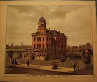
WOOLMAN AND ROSE ATLAS OF THE JERSEY COAST
LONG BRANCH: GRADED SCHOOL
1878. WOOLMAN AND ROSE ATLAS OF THE JERSEY COAST. LONG BRANCH 1878: GRADED SCHOOL. A hand-colored original 11.5-inch by 14-inch view of the Long Branch Graded School. $100.00. <br/><br/> unknown
Bookseller reference : 26056
|
|
|
WOOLMAN AND ROSE ATLAS OF THE NEW JERSEY COAST
LONG BRANCH: DR. T.G. CHATTLE
1878. WOOLMAN AND ROSE ATLAS OF THE NEW JERSEY COAST. LONG BRANCH 1878: DR. T.G. CHATTLE. An 11.5-inch by 14.4-inch hand-colored engraving depicting a side-view of the residence of Dr. T.G. Chattle Long Branch. With a small portrait Chattle above the image. $85.00. <br/><br/> unknown
Bookseller reference : 32030

|
|
|
WOOLMAN AND ROSE ATLAS OF THE NEW JERSEY COAST
LONG BRANCH/ CAPE MAY: GERMANIA HOTEL HUGHES BORTHERS LUMBER
1878. WOOLMAN AND ROSE ATLAS OF THE NEW JERSEY COAST. LONG BRANCH AND CAPE MAY 1878. An 11.5-inch by 14-inch print depicting two different etchings. The top etching is a corner view of the Germania Hotel F. Morin & Son Proprietors Corner of 2nd & Balt. Avenues Long Branch. The lower etching depicts the property home & building of the Hughes Brothers Lumber & Building Materials Sea Grove Cape May. $45.00. <br/><br/> unknown
Bookseller reference : 26681

|
|
|
WOOLMAN AND ROSE ATLAS OF THE NEW JERSEY COAST
LONG BRANCH: EXOTIC GARDENS AND NURSERIES
1878. WOOLMAN AND ROSE ATLAS OF THE NEW JERSEY COAST. LONG BRANCH 1878: EXOTIC GARDENS. Nice view of George W. Houghton Exotic Gardens Long Branch. $45.00. <br/><br/> unknown
Bookseller reference : 26059

|
|
|
WOOLMAN AND ROSE ATLAS OF THE NEW JERSEY COAST
LONG BRANCH: DR. T.G. CHATTLE
1878. WOOLMAN AND ROSE ATLAS OF THE NEW JERSEY COAST. LONG BRANCH 1878: DR. T.G. CHATTLE. Side-view of the residence of Dr. T.G. Chattle Long Branch with a small portrait of him above the house. $45.00. <br/><br/> unknown
Bookseller reference : 26058

|
|
|
WOOLMAN AND ROSE ATLAS OF THE NEW JERSEY COAST
MANASQUAN: DR. ROBERT LAIRD RESIDENCE
1878. WOOLMAN AND ROSE ATLAS OF THE NEW JERSEY COAST. MANASQUAN 1878: DR. ROBERT LAIRD. A print showing the residence of Dr. Robert Laird in Squan. Squan is now known as Manasquan. $45.00. <br/><br/> unknown
Bookseller reference : 26203

|
|
|
WOOLMAN AND ROSE ATLAS OF THE NEW JERSEY COAST
MANASQUAN: OSBORN HOUSE
1878. WOOLMAN AND ROSE ATLAS OF THE NEW JERSEY COAST. MANASQUAN 1878: OSBORN HOUSE. A print showing the Osborn House in Squan. Property of T. Fields. Squan is now known as Manasquan. $45.00. <br/><br/> unknown
Bookseller reference : 26210

|
|
|
WOOLMAN AND ROSE ATLAS OF THE NEW JERSEY COAST
MANASQUAN: OSBORNE CURTIS
1878. WOOLMAN AND ROSE ATLAS OF THE NEW JERSEY COAST. MANASQUAN VILLAGE 1878: ORBORNE CURTIS. A print showing the store property of Osborne Curtis in Squan Village. Squan Village is now known as Manasquan. $45.00. <br/><br/> unknown
Bookseller reference : 26212

|
|
|
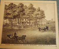
WOOLMAN AND ROSE ATLAS OF THE NEW JERSEY COAST
MANASQUAN: JOHN S. ROGERS RESIDENCE
1878. WOOLMAN AND ROSE ATLAS OF THE NEW JERSEY COAST. MANASQUAN 1878: JOHN S. ROGERS RESIDENCE. A print showing the property and residence of John S. Rogers in Squan. Squan is now known as Manasquan. $45.00. <br/><br/> unknown
Bookseller reference : 26213
|
|
|
WOOLMAN AND ROSE ATLAS OF THE NEW JERSEY COAST
MANASQUAN: UNION HOUSE
1878. WOOLMAN AND ROSE ATLAS OF THE NEW JERSEY COAST. MANASQUAN 1878: UNION HOUSE. A print showing a view of The Union House and its surroundings in Squan. Property of John M. Brown. Squan is now known as Manasquan. $45.00. <br/><br/> unknown
Bookseller reference : 26207

|
|
|
WOOLMAN AND ROSE ATLAS OF THE NEW JERSEY COAST
MANASQUAN: OSBORN HOUSE
1878. WOOLMAN AND ROSE ATLAS OF THE NEW JERSEY COAST. MANASQUAN 1878: OSBORN HOUSE. A hand-colored print depicitng the Osborn House in Squan. Property of T. Fields. Squan is now known as Manasquan. $85.00. <br/><br/> unknown
Bookseller reference : 32576

|
|
|
WOOLMAN AND ROSE ATLAS OF THE NEW JERSEY COAST
MANASQUAN: JOHN S. ROGERS RESIDENCE
1878. WOOLMAN AND ROSE ATLAS OF THE NEW JERSEY COAST. MANASQUAN 1878: JOHN S. ROGERS RESIDENCE. An 11.5-inch by 14-inch hand-colored print showing the property and residence of John S. Rogers several strollers and three horse and buggy teams. Squan is now known as Manasquan. $85.00. <br/><br/> unknown
Bookseller reference : 33046

|
|
|
WOOLMAN AND ROSE ATLAS OF THE NEW JERSEY COAST
MANASQUAN: DR. ROBERT LAIRD RESIDENCE
1878. WOOLMAN AND ROSE ATLAS OF THE NEW JERSEY COAST. MANASQUAN 1878: DR. ROBERTLAIRD. A hand-colored print showing the residence of Dr. Robert Laird in Squan. Squan is now known as Manasquan. $75.00. <br/><br/> unknown
Bookseller reference : 42881

|
|
|
WOOLMAN AND ROSE ATLAS OF THE NEW JERSEY COAST
MAYS LANDING 1878 MAP
1878. WOOLMAN AND ROSE ATLAS OF THE NEW JERSEY COAST. MAYS LANDING MAP 1878. An 11-inch by 14-inch map of Mays Landing. $45.00. <br/><br/> unknown
Bookseller reference : 26658

|
|
|
WOOLMAN AND ROSE ATLAS OF THE NEW JERSEY COAST
MONMOUTH COUNTY: OCEANPORT/MANASQUAN/SEA CLIFF/WEST CREEK
1878. WOOLMAN AND ROSE ATLAS OF THE NEW JERSEY COAST. MONMOUTH COUNTY 1878. A print featuring four different panels. The farm & residence of J.B. Scholl West Creek The Park Hotel H.B. Edwards Oceanport Wills & Borton Sea Cliff Hot & Cold Sea Water Bathing Establishment in East Long Branch & the residence of Dr. A.A. Higgins in Squan Villa. $45.00. <br/><br/> unknown
Bookseller reference : 26260

|
|
|
WOOLMAN AND ROSE ATLAS OF THE NEW JERSEY COAST
OCEAN COUNTY: WEST CREEK CRANBERRY PLANTATION
1878. WOOLMAN AND ROSE ATLAS OF THE NEW JERSEY COAST. WEST CREEK CRANBERRY PLANTATION 1878. Print showing the Stafford Forge Cranberry Plantation West Creek Ocean County the property of Daniel R. Gowdy. Hand-colored. $100.00. <br/><br/> unknown
Bookseller reference : 26100

|
|
|
WOOLMAN AND ROSE ATLAS OF THE NEW JERSEY COAST
OCEAN GROVE: PARLORS OF THE ARLINGTON
1878. WOOLMAN AND ROSE ATLAS OF THE NEW JERSEY COAST. OCEAN GROVE: PARLORS OF THE ARLINGTON 1878. A hand-colored original 11.5-inch by 14-inch print showing the Parlors of the Arlington in Ocean Grove property of Charles E. Howland. $100.00. <br/><br/> unknown
Bookseller reference : 26194

|
|
|
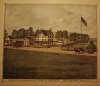
WOOLMAN AND ROSE ATLAS OF THE NEW JERSEY COAST
POINT PLEASANT: CHAS. W MAXSON RESIDENCE
1878. WOOLMAN AND ROSE ATLAS OF THE NEW JERSEY COAST. POINT PLEASANT 1878: CHAS. W. MAXSON RESIDENCE. An 11.5-inch by 14-inch engraving depicting the property and residence of Charles W. Maxson in Point Pleasant. $45.00. <br/><br/> unknown
Bookseller reference : 26664

|
|
|
WOOLMAN AND ROSE ATLAS OF THE NEW JERSEY COAST
POINT PLEASANT: CHAS. W. MAXSON RESIDENCE
1878. WOOLMAN AND ROSE ATLAS OF THE NEW JERSEY COAST. POINT PLEASANT: CHAS. W. MAXSON RESIDENCE. 1878. An 11.5-inch by 14-inch hand-colored engraving depicting the property and residence of Charles W. Maxson in Point Pleasant. $85.00. <br/><br/> unknown
Bookseller reference : 26517
|
|
|
WOOLMAN AND ROSE ATLAS OF THE NEW JERSEY COAST
POINT PLEASANT: ARNOLD HOUSE
1878. WOOLMAN AND ROSE ATLAS OF THE NEW JERSEY COAST. POINT PLEASANT 1878: ARNOLD HOUSE. An 11.5-inch by 14-inch print depicting a full view of the Arnold House and adjoining horse field owned by J. Arnold P'r. $45.00. <br/><br/> unknown
Bookseller reference : 26666

|
|
|
WOOLMAN AND ROSE ATLAS OF THE NEW JERSEY COAST
POINT PLEASANT: WHITE LAWN CEMETERY
1878. WOOLMAN AND ROSE ATLAS OF THE NEW JERSEY COAST. POINT PLEASANT 1878 CEMETERY MAP. A 14-inch by 11-inch map of the plan of the White Lawn Cemetery in Point Pleasant. $10.00. <br/><br/> unknown
Bookseller reference : 26215

|
|
 Receive by email
 Download as PDF document
 RSS feed


