|
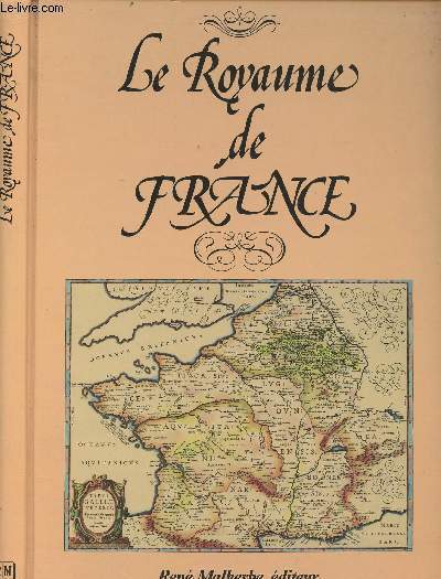
Blaeu Jean
Le Royaume de France - Le grand Atlas, ou cosmographie Blauviane, en laquelle est exactement décritte La Terre, la Mer et le Ciel
René Malherbe. 1987. In-4. Relié. Bon état, Couv. convenable, Dos satisfaisant, Intérieur frais. 287 pages augmentées de très nombreuses cartes en noir et blanc hors texte.. . . . Classification Dewey : 912-Atlas, cartes et plans
书商的参考编号 : R240153649
|
|
|
Blaeu Jean
Le royaume de France - Le grand Atlas.
René Malherbe. 1987. In-4. Relié. Bon état, Couv. convenable, Dos satisfaisant, Papier jauni. 287 pages, nombreuses illustrations en noir et blanc hors texte et quelques lettrines en noir et blanc dans le texte.. . . . Classification Dewey : 912-Atlas, cartes et plans
书商的参考编号 : R200136840
|
|
|
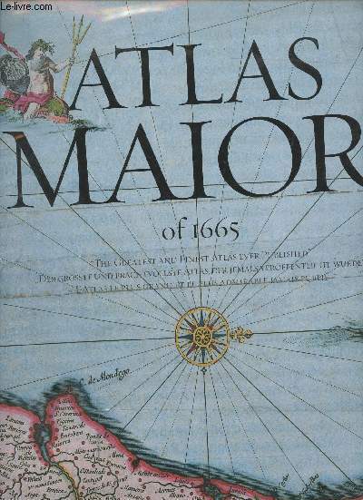
Blaeu Joan
Atlas Maior of 1665
Taschen. Non daté. In-Folio. Relié. Bon état, Couv. convenable, Dos satisfaisant, Intérieur frais. 593 pages. Signet conservé. Jaquette correcte. Frontispice illustré en couleurs. Nombreuses cartes en couleurs, in et hors texte. Texte en français, anglais et allemand.. . . . Classification Dewey : 912-Atlas, cartes et plans
书商的参考编号 : RO30352137
|
|
|
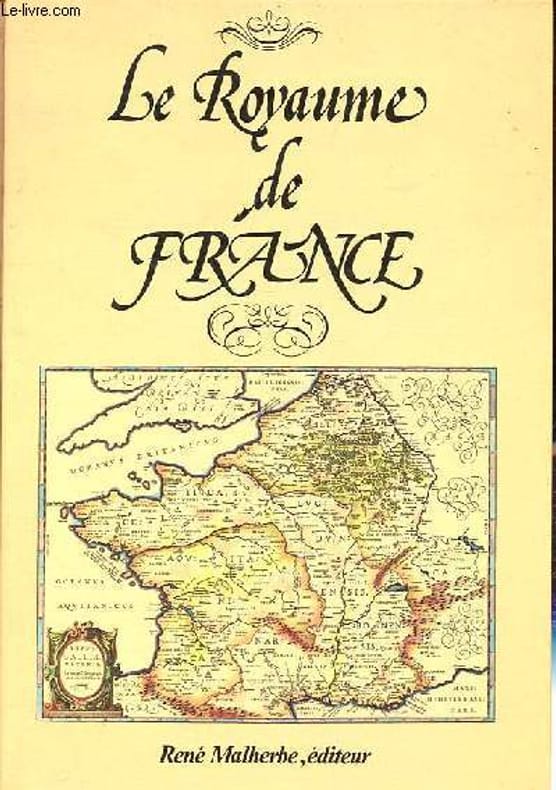
Blaeu Joan
Le royaume de France
René Malherbe, éditeur 1987 In-4 cartonnage éditeur. 30 cm sur 21,5. 287 pages. Fac-similé de l’Atlas de Jean Blaeu. Nombreuses cartes hors-texte en noir et blanc. Bon état d’occasion.
书商的参考编号 : 117556
|
|
|
Blaeu Joan
Le Royaume de France- Le Grand Atlas ov cosmographie Blaviane en laquelle est exactement descrite la Terre, la mer et le ciel
René Malherbe. 1987. In-4. Cartonné. Bon état, Couv. convenable, Dos satisfaisant, Intérieur frais. 287 pages. Lettrines. Nombreuses cartes en noir et blanc, hors texte. Texte en Ancien Français. Rares rousseurs.. . . . Classification Dewey : 912-Atlas, cartes et plans
书商的参考编号 : RO30333869

|
|
|
BLAEU Joan
Toonneel der Steden van de Vereenighde Nederlanden met hare beschrijvingen. Met hare beschrijvingen uytgegeven by Joan Blaeu [Steden van Holland en Westfriesland /Utrecht]
Lausanne / Amsterdam, Sequioa / Elsevier 1966 facsimile van de originele uitgave in het bezit van de Stichting "Museum Enschedé - Haarlem", [200]pp. met [52] plattegronden en stadsgezichten in kleur, 56x34cm., simili-lederen band met wapenschilden in goudopdruk, gedrukt op "vergé teinté de Hollande, 145gr., des papeteries royales Van Gelder zonen N.V. d'Amsterdam", goede staat, A69091
书商的参考编号 : A69091
|
|
|
BLAEU Joan
Toonneel der Steden van de Vereenighde Nederlanden met hare beschrijvingen. Met hare beschrijvingen uytgegeven by Joan Blaeu [Steden van Holland en Westfriesland /Utrecht]
facsimile van de originele uitgave in het bezit van de Stichting "Museum Enschedé - Haarlem", [200]pp. met [52] plattegronden en stadsgezichten in kleur, 56x34cm., simili-lederen band met wapenschilden in goudopdruk, gedrukt op "vergé teinté de Hollande, 145gr., des papeteries royales Van Gelder zonen N.V. d'Amsterdam", goede staat, A69091
|
|
|
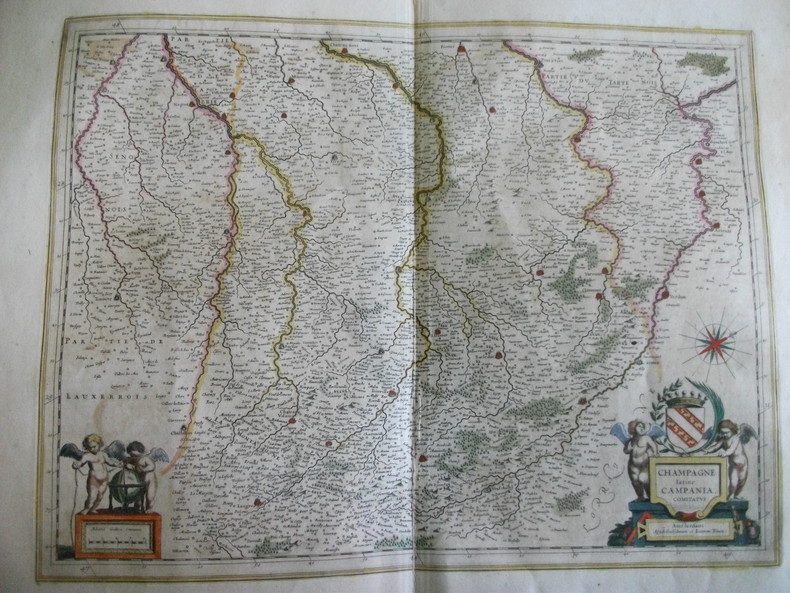
BLAEU Joannem Amsterdam
Carte de la Champagne Latine Campagnia Comitatus
Format 50 x38,5cm 62x51cm avec les marges.Belle carte gravée en couleurs du XVIIème siècle titre dans cartouche, petites déchirures marginales.Texte en français,au verso. Coloris frais
书商的参考编号 : 4059
|
|
|
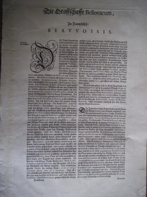
BLAEU Johannes
Comitatus Bellovacum vernaculé BEAUVAIS
carte gravée sur cuivre, vers 1650, Titre dans cartouche, texte en allemand. Format 570x475mm avec marges
书商的参考编号 : 10040
|
|
|
Blaeu, (Willem Janszoon und Joan )
Blaeu. Der Grosse Atlas. Die Welt im 17. Jahrhundert. Einführung, Texte und Auswahl der Karten von John Goss. Vorwort von Peter Clark. Hrsg. in Zusammenarbeit mit der Royal Geographical Society, London.
Neff, Wien (1990). Mit 100 farbigen Karten. 2°. 224 S. OPpbd. Schutzumschlag gering bestossen. Gutes Exemplar.
书商的参考编号 : 41097
|
|
|
Blaeu, (Willem Janszoon und Joan )
Blaeu. Der Grosse Atlas. Die Welt im 17. Jahrhundert. Einführung, Texte und Auswahl der Karten von John Goss. Vorwort von Peter Clark. Hrsg. in Zusammenarbeit mit der Royal Geographical Society, London.
Neff, Wien (1990). Mit 100 farbigen Karten. 2°. 224 S. OPpbd. Schutzumschlag leicht berieben. Gutes Exemplar.
书商的参考编号 : 36264
|
|
|
Blaeu, J
Atlas Maior of 1665. Einführung und Texte von P. van der Krogt. Mit einer Auswahl der Originaltexte von Joan Blaeu. Reprint der farb. Karten nach dem Original [Ausgabe Joan Blaeu, Amsterdam 1665] aus der Österr. Nationalbibliothek, Wien.
Köln, Taschen ( 2010). Gr.4°. 512 S. Mit zahlr. farb. Karten. Original-Pappband mit Schutzumschlag. im Orig.-Schuber.
书商的参考编号 : 181672-1
|
|
|
Blaeu, Joan
Atlas maior of 1665 - Italia : "the greatest and finest atlas ever published" ; based on the copy in the Österreichische Nationalbibliothek, Wien. Introd. and texts by Peter van der Krogt. With a selection of orig. texts by Joan Blaeu. [Transl. from Dutsch into Engl.: Jennifer Schaudies ...]
Hongkong ; Köln ; London ; Los Angeles ; Madrid ; Paris ; Tokyo : Taschen 2006. 207 S. : zahlr. Ill., Kt. ; 39 cm Pappe [3 Warenabbildungen] 0
书商的参考编号 : 76519

|
|
|
Blaeu, Joan
Atlas maior of 1665 : sämtliche 124 Karten von Germanien, Österreich und der Schweiz ; nach dem Original aus der Österreichischen Nationalbibliothek Wien. Einf. und Texte von Peter van der Krogt. Mit einer Ausw. der Orig.-Texte von Joan Blaeu
Hongkong ; Köln ; London ; Los Angeles ; Madrid ; Paris ; Tokyo : Taschen 2006. 404 S., 40 cm Pappe 0
书商的参考编号 : 70330

|
|
|
Blaeu, Joan
Atlas maior of 1665 : sämtliche 124 Karten von Germanien, Österreich und der Schweiz ; nach dem Original aus der Österreichischen Nationalbibliothek Wien. Einf. und Texte von Peter van der Krogt. Mit einer Ausw. der Orig. -Texte von Joan Blaeu englisch; französisch; deutsch
Hongkong ; Köln ; London ; Los Angeles ; Madrid ; Paris ; Tokyo : Taschen Verlag 2006. 40 cm, zusammen 404 Seiten durchgehend mit farbigen Karten und einigen Illustrationen, Originalumschläge in farbig Pp., gebundene Ausgabe, Hardcover/Pappeinband, Original-Pappschuber - sehr guter Zustand
书商的参考编号 : 59851

|
|
|
Blaeu, Joan
Atlas maior of 1665 : the greatest and finest atlas ever published. "Der größte und prachtvollste Atlas, der jemals veröffentlicht wurde". "L`Atlas le plus grand et le plus admirable jamais publie" With a selection of orig. texts by Joan Blaeu. Introd. and texts by Peter van der Krogt. [Transl.: Jeniffer Schaudies ...]
Köln : Taschen 2010. Based on the copy in the / Nach dem Original aus der / D`apres l`original de la Österreichische Nationalbibliothek, Vienna. With a selection of original texts by / Mit einer Auswahl der Originaltexte von / Avec une selection de textes originaux de Joan Blaeu. 512 S. : Ill., Kt. ; 39 cm Pappe 0
书商的参考编号 : 79782

|
|
|
Blaeu, Joan
Atlas maior of 1665 [REPRINT der der Ausg. Amsterdam. 1665]. Sämtliche 124 Karten von Germanien, Österreich und der Schweiz. Nach dem Original aus der Österreichischen Nationalbibliothek Wien Verantwortlichkeitsangabe: Joan Blaeu. Einf. und Texte von Peter van der Krogt. Mit einer Ausw. der Orig.-Texte von Joan Blaeu. 2 Bde. (= komplett).
Köln, Taschen, 2006. 215; S. 223-404, überwiegend farb. Ktn. 39 cm. OPp im stabilen, illustr. OSchuber.
书商的参考编号 : 94603

|
|
|
Blaeu, Joan
Atlas Maior of 1665. Germania (Germanien - Germania - Germanie), Austria & Helvetia (Germanien, Österreich und Schweiz - Germania , Austria and Switzerland - Germanie Autriche et Suisse).
Hongkong, Köln, London et. al.., Benedikt Taschen Verlag., 2006. Sämtliche 124 Karten von Germanien, Österreich und der Schweiz sowie Originaltexte von Joan Bleau aus einem Atlas Maior von 1665, "Dem grössten und prachtvollsten Atlas, der jemals veröffentlicht wurde". Einführung und Texte von / Introduction ... / Introduction... Peter van der Krogt. Nach dem Original aus der / Based on... / D'apres ... Österreichische Nationalbibliothek, Wien. Directed and produced by Benedikt Taschen. Zwei Bände, 404 Seiten, im gestalteten Schuber. Guter Zustand. 2°. OPappband mit OUmschlag.
书商的参考编号 : 057444
|
|
|
Blaeu, Joan
Atlas Major. Der große Atlas. Die Welt im 17. Jahrhundert. Einführung, Texte und Auswahl der Karten von John Goss.
Wien: Neff 1990. 224 S., mit zahlr. Kartenabb. 2° Ln.mS. *neuwertig*
书商的参考编号 : 266834
|
|
|
Blaeu, Joan
Der große Atlas. Die Welt im 17. Jahrhundert. Einführung, Texte und Auswahl der Karten von John Goss.
Wien, Neff, 1990. 2. 224 S. geb., vergold. Rück.-u. Deck.-Tit., OU. OU leicht berieben, sehr guter Zust., sauber erhalten.
书商的参考编号 : 54992AB
|
|
|
Blaeu, Joan
Der grosse Weltatlas. Die Welt im 17. Jahrhundert.
Wien, Neff, 1990. dt. Erstausg. 223 S., überw. Kt. Kart., or.-Umschl. Titelbl. gestempelt, sonst sehr guter Zustand. 1
书商的参考编号 : 7364BB
|
|
|
Blaeu, Johan
Der Große Atlas. Die Welt im 17. Jahrhundert. Einführung, Texte und Auswahl der Karten von J. Goss. Vorwort von P. Clark.
Wien, P. Neff ( 1990). Gr.4°. 224 S. Mit 100 farb. Karten. Original-Pappband mit Schutzumschlag.
书商的参考编号 : 301788-1 ???????? : 370140304
|
|
|
BLAEV & COLLECTIF
La France, Provinces. 1620 - 1680
LES LABORATOIRES MARINIER. 193.9. In-4. Cartonnage d'éditeurs. Bon état, Couv. légèrement passée, Dos satisfaisant, Quelques rousseurs. 32 livraisons, contenant chacune 4 pages : plan en couleurs et quelques photos en héliogravure.. . . . Classification Dewey : 912-Atlas, cartes et plans
书商的参考编号 : RO80159184
|
|
|
Blaev et collectif
La France - Provinces - Présentation des cartes de Blaev 1620 - 1680
Les laboratoires Marinier. 1939. In-4. En feuillets. Etat d'usage, Couv. légèrement passée, Dos plié, Intérieur acceptable. 24 livraisons contenanrt chacune 4 pages : 1 plan en couleurs et quelques photos en héliogravure. Livraisons de 1 à 21, 23, 26, et 70. Le tout dans une chemise cartonnée. coiffe en tête de la chemise légèrement abîmée.. . . . Classification Dewey : 912-Atlas, cartes et plans
书商的参考编号 : R240156926

|
|
|
BLANC JEAN-LOUIS
LES GRANDS FLEUVES DU MONDE - AUX SOURCES DE LA VIE
GLENAT. 2003. In-4. Relié. Bon état, Couv. convenable, Dos satisfaisant, Intérieur frais. 191pages.Nombreuses photos et cartes en couleurs et noir et blanc, dans et hors texte + 1 carte dépliante en début d'ouvrage.Jaquette en bon état.. Avec Jaquette. . . Classification Dewey : 912-Atlas, cartes et plans
书商的参考编号 : R200072767 ???????? : 272344113
|
|
|
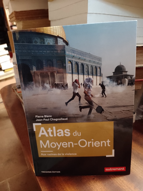
BLANC Pierre & CHAGNOLLAUD Jean-Paul
Atlas du Moyen-Orient. Aux racines de la violence
Paris, Autrement, "Atlas/Monde", juin 2023, 17,5 x 25, 95 pages cousues sous couverture illustrée. Iconographie couleurs, - cartographie : Claire Levasseur. Troisième édition.
书商的参考编号 : MOYORIENT55550623
|
|
|
Blanchard, Theophile und Barrere Freres
Atlas geographique et iconographique du cour complet d`ecriture sainte.
Paris, Ateliers catholiques du Petit-Montrouge, 1844. 3 Bll. (Vortitel, Titel, Avertissement). 77 teils gefalt. Tafeln (meist in Stahlstich, teils in Lithographie). 4°. HLdr.der Zeit (stark beschabt und bestoßen, Rücken-Kapitelle geklebt). [5 Warenabbildungen]
书商的参考编号 : 17558

|
|
|
Blanchet (adrien), ss la dir. de
Carte archéologique de la Gaule romaine. Le département du Gard.
Paris Presses Universitaires de France 1962 Un volume in-4 broché, 226 pp. et 3 pl. hors-texte, et un port-folio comprenant un plan de Nîmes et une carte du tracé du Pont-du-Gard. Bon état, intérieur frais.
书商的参考编号 : 2217
|
|
|
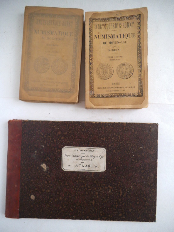
BLANCHET J. Adrien
Nouveau manuel de numismatique du Moyen âge et moderne.
Première et deuxième partie.In 12 broché, fac-similé de couverture, titre manuscrit à la plume, les deux plats de couverture, d’origine, sont contrecollés. Faux-titre, titre, 552 pages, Librairie encyclopédique Roret 1890. On joint l’atlas in 12 à l’italienne, demi-cuir rouge titre, filets dorés. Faux-titre, titre, 31 pages, 645 figures en 14 planches, sur double page, montées sur onglets. Rousseurs, plus fortes en début et fin de volume, petite mouillure en marge extérieure en fin de volume
书商的参考编号 : 9594
|
|
|
BLANCHON DAVID
ATLAS MONDIAL DE L'EAU
AUTREMENT. VERS 2013. In-8. Broché. Bon état, Couv. convenable, Dos satisfaisant, Intérieur frais. 96 pages. Nombreuses cartes en couleurs dans et hors texte.. . . . Classification Dewey : 912-Atlas, cartes et plans
书商的参考编号 : R200072960
|
|
|
BLANGUERNON, Cl.
Le Hoggar.
Paris, Arthaud, 1955. grand in-8°, 228 pages, front., 1 carte h.t., croquis in-t., tabl., index, cartonnage toile decor ed.
书商的参考编号 : 13102
|
|
|
BLANGUERNON, Cl.
Le Hoggar.
grand in-8°, 228 pages, front., 1 carte h.t., croquis in-t., tabl., index, cartonnage toile decor ed. Ouvrage illustre de 55 heliogravures. [GE-3]
|
|
|
Blase, Karl Oskar (1925 Köln - 2016 Kassel)
Original-Filmplakat "Richard III", Regie Sir Laurence Oliver, 1955. Farblithographie und Offsett.
1955. Auf etwas festerem Posterpapier. In der Fom signiert. 59,5 x 84 cm.
书商的参考编号 : 180264

|
|
|
Blase, Karl Oskar (1925 Köln - 2016 Kassel)
Original-Filmplakat. Daddy Langbein (Daddy Long Legs), Regie Jean Negulesco. Farblithographie und Offset.
1955. Auf dünnem Posterpapier. In der Form signiert. 84,5 x 59,5 cm.
书商的参考编号 : 180263

|
|
|
BLASSELLE RENE / BONNET MARC / SERRYN PIERRE
LES ATLAS - ATLAS GEOGRAPHIQUE - ATLAS HISTORIQUE TOME SECOND
BORDAS. non daté. In-4. Relié. Bon état, Couv. convenable, Dos satisfaisant, Intérieur frais. 144 + 32 pages - nombreuses cartes en couleur. . . . Classification Dewey : 912-Atlas, cartes et plans
书商的参考编号 : RO30132505
|
|
|
BLAVIGNAC (Jean-Daniel)
Histoire de l'architecture sacrée du quatrième au dixième siècle dans les anciens évêchés de Genève, Lausanne et Sion [Atlas seul].
Lausanne, Georges Bridel, 1853 1 volume Format oblong (43,5 x 22,5cm) Broché sous couverture aux plats à filet noir d'encadrement avec petits motifs angulaires; logo de l'éditeur au 2nd plat. 1faux-titre, 1titre, 1feuillet, 82 planches, 1feuillet. Couverture endommagée: dos manquant, remplacé par un papier contrecollé, plats cornés avec petits manques marginaux; planches en bon état.
书商的参考编号 : 3963
|
|
|
BLAVIGNAC (Jean-Daniel)
Histoire de l'architecture sacrée du quatrième au dixième siècle dans les anciens évêchés de Genève, Lausanne et Sion [Atlas seul].
1ère édition, bien complète des 82 planches, de l'atlas de l'ouvrage publié par Jean-Daniel BLAVIGNAC, architecte, historien et archéologue qui participa à la construction et à la restauration d'édifices religieux et civils suisses, conseiller municipal genevois (1817-1876): fragments de l'Ecole gallo-latine, détails d'églises et autres monuments, fresques, motifs décoratifs, moulures, etc. Français
|
|
|
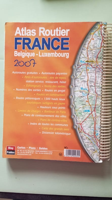
Blay-Foldex
Atlas routier France belgique - luxembourg
blay foldex 2006 2006.
书商的参考编号 : 500224514
|
|
|
BLIN Colonel
APERCUS SUR LA GUERRE 1914-1918.
Paris Charles-Lavauzelle et Cie 1932. In-8 198pp et 1 atlas portefeuilles relié à l'identique du volume de texte. Demi basane noire, dos à nerfs orné de filets dorés, rel époque. Illustré de 36 croquis de batailles, certains repliés ou dépliants, réunis dans un atlas portefeuilles. Bel exp.
书商的参考编号 : GITb408
|
|
|
BLONDEL
CARTE FRONTIERE FRANCO-ALLEMANDE - SUPPLEMENT AU NUMERO L'ILLUSTRATION DU 11 NOVEMBRE 1939
BLONDEL LA ROUGERY. 1939. In-Plano. En feuillets. Bon état, Couv. convenable, Dos satisfaisant, Intérieur frais. CARTE en couleurs. FRONTIERE FRANCO-ALLEMANDE - SUPPLEMENT AU NUMERO L'ILLUSTRATION DU 11 NOVEMBRE 1939. . . . Classification Dewey : 912-Atlas, cartes et plans
书商的参考编号 : RO80202934
|
|
|
BLONDEL
PLAN BLONDEL PARIS ET BANLIEUE - ECHELLE 18.000E
BLONDEL LA ROUGERY. Non daté. In-Plano. En feuillets. Bon état, Couv. convenable, Dos satisfaisant, Intérieur frais. PLAN BLONDEL PARIS ET BANLIEUE - ECHELLE 18.000E. . . . Classification Dewey : 912-Atlas, cartes et plans
书商的参考编号 : RO80202933
|
|
|
Blondel La Rougery
Cartes départementale au 1:200 000e - N°64 - Extrait Agrandi des cartes Campbell - BASSES PYRENEES -
Blondel La Rougery. Non daté. In-Plano. En feuillets. Etat d'usage, Couv. convenable, Dos satisfaisant, Déchirures. 1 carte des basses Pyrénées au 1.200.000e.. . . . Classification Dewey : 912-Atlas, cartes et plans
书商的参考编号 : RO80207165

|
|
|
BLONDEL LA ROUGERY.
CARTE BLONDEL. HAUT RHIN. TERRITOIRE DE BELFORT.
CHEZ L AUTEUR.. Non daté. In-Plano. Broché. Bon état, Couv. convenable, Dos satisfaisant, Pliures. Carte en couleurs de 56 cm / 76 cm.. . . . Classification Dewey : 912-Atlas, cartes et plans
书商的参考编号 : R150168872

|
|
|
BLONDEL LA ROUGERY.
CARTE BLONDEL. HAUT RHIN. TERRITOIRE DE BELFORT.
CHEZ L AUTEUR.. Non daté. In-Plano Carré. Broché. Bon état. Couv. convenable. Dos satisfaisant. Pliures. Carte en couleurs de 56 cm / 76 cm.

|
|
|
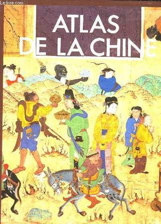
BLUDEN C. - ELVIN M.
ATLAS DE LA CHINE
EDITIONS DU FANAL. 1987. In-4. Relié. Bon état, Couv. convenable, Dos satisfaisant, Intérieur frais. 238 pages. Nombreuses illustrations en noir et blanc et en couleurs dans le texte et hors texte.. Avec Jaquette. . . Classification Dewey : 912-Atlas, cartes et plans
书商的参考编号 : RO30057067
|
|
|
BLUNDEN C. et ELVIN M.
Atlas de la Chine.
Editions du Fanal, 1987, in-4 de 238 pages, reliure d'éditeur, jaquette illustrée, 58 cartes, 365 photographies et de nombreuses illustrations, une chronologie et une bibliographie. C1500g. Bel exemplaire, en très bon état.
书商的参考编号 : 25615

|
|
|
Bob Ward on the truth about Drake and the Pacific Susan Cole on an early atlas of Asia Frederic Archambault on mapping the i
Map Collector Winter 1988 Issue No. 45
Map Collector Publications. Used - Very Good. Very Good condition. Winter 1988 Issue No. 45. Map Collector Publications unknown
书商的参考编号 : S13J-00417
|
|
|
Bochow, Karl-Heinz und Peter Dr. Göbel
Das große ADAC-Tourenbuch: Zauber und Schönheit unserer Heimat Teil 1 + Teil 2 1 Buch + Kasette mit Wanderkarten
München: ADAC Verlag GmbH, 1993. 320 Seiten + Kasette mit Wanderkarten 26 cm, Pappeinband
书商的参考编号 : 48502
|
|
|
Bochow, Karl-Heinz und Peter Dr. Göbel
Zauber und Schönheit unserer Heimat Teil 1- Das große ADAC-Tourenbuch
München: ADAC Verlag GmbH, 1993. o.A. 318 Seiten , 26 cm, Pappeinband
书商的参考编号 : 13047

|
|
|
Bochow, Karl-Heinz, Klaus Bötig, Hans Bünte u. a
Reader's Digest Auto-Reise-Buch Deutschland : unterwegs zu d. schönsten Zielen / Red.: Birgit Gläser...
Stuttgart [u.a.] : Verl. Das Beste, c 1998. 712 S. : Ill., überw. Kt. 4°. 1. Aufl. Geb. in ill. OPpbd. mit 2 Lesebändchen.
书商的参考编号 : 36161 ???????? : 387070778
|
|
 ?????????
 ?????PDF???
 RSS feed


