|
CARTES TARIDE
GRANDE CARTE ROUTIERE LES BORDS DU RHIN - DE COLOGNE A MAYENCE A L'USAGE DES CYCLISTES ET AUTOMOBILISTES N°26
EDITIONS TARIDE. Non daté. In-Plano. Broché. Etat d'usage, Couv. légèrement passée, Dos satisfaisant, Intérieur acceptable. Carte dépliante en couleurs en 18 volets, en couleurs au 1/350.000e dans une pochette.. . . . Classification Dewey : 912-Atlas, cartes et plans
書籍販売業者の参照番号
: RO70122738
|
|
|
CARTES TARIDE
GRANDE CARTE ROUTIERE LYONNAIS, SAVOIE ET DAUPHINE A L'USAGE DES CYCLISTES ET AUTOMOBILISTES N°14
EDITIONS TARIDE. Non daté. In-Plano. Broché. Etat d'usage, Couv. légèrement passée, Dos satisfaisant, Intérieur acceptable. Carte dépliante en couleurs en 30 volets, en couleurs au 1/250.000e dans une pochette.. . . . Classification Dewey : 912-Atlas, cartes et plans
書籍販売業者の参照番号
: RO70122534
|
|
|
CARTES TARIDE
GRANDE CARTE ROUTIERE NORMANDIE (OUEST), BRETAGNE(NORD) N°5
EDITIONS TARIDE. Non daté. In-Plano. Broché. Bon état, Couv. convenable, Dos satisfaisant, Intérieur frais. Carte dépliante en couleurs en 30 volets, en couleurs au 1/250.000e dans une pochette abîmée.. . . . Classification Dewey : 912-Atlas, cartes et plans
書籍販売業者の参照番号
: RO70122528
|
|
|
CARTES TARIDE
GRANDE CARTE ROUTIERE PARIS, BRIE, CHAMPAGNE (SUD) A L'USAGE DES CYCLISTES ET AUTOMOBILISTES N°7
EDITIONS TARIDE. Non daté. In-Plano. Broché. Etat d'usage, Couv. légèrement passée, Dos satisfaisant, Intérieur acceptable. Carte dépliante en couleurs en 30 volets, en couleurs au 1/250.000e dans une pochette abîmée.. . . . Classification Dewey : 912-Atlas, cartes et plans
書籍販売業者の参照番号
: RO70122530
|
|
|
CARTES TARIDE
GRANDE CARTE ROUTIERE PARIS, CHAMPAGNE (NORD), ARDENNES N°3
EDITIONS TARIDE. Non daté. In-Plano. Broché. Etat d'usage, Couv. légèrement passée, Dos satisfaisant, Intérieur acceptable. Carte dépliante en couleurs en 30 volets, en couleurs au 1/250.000e dans une pochette abîmée.. . . . Classification Dewey : 912-Atlas, cartes et plans
書籍販売業者の参照番号
: RO70122527
|
|
|
CARTES TARIDE
GRANDE CARTE ROUTIERE SECTION OUEST A L'USAGE DES CYCLISTES ET AUTOMOBILISTES N°19
EDITIONS TARIDE. Non daté. In-Plano. Broché. Etat d'usage, Couv. légèrement passée, Dos satisfaisant, Intérieur acceptable. Carte dépliante en couleurs en 30 volets, en couleurs au 1/250.000e dans une pochette usée.. . . . Classification Dewey : 912-Atlas, cartes et plans
書籍販売業者の参照番号
: RO70122731
|
|
|
CARTES TARIDE
GRANDE CARTE ROUTIERE VENDEE A L'USAGE DES CYCLISTES ET AUTOMOBILISTES N°13
EDITIONS TARIDE. Non daté. In-Plano. Broché. Etat d'usage, Couv. légèrement passée, Dos satisfaisant, Intérieur acceptable. Carte dépliante en couleurs en 30 volets, en couleurs au 1/250.000e dans une pochette abîmée.. . . . Classification Dewey : 912-Atlas, cartes et plans
書籍販売業者の参照番号
: RO70122531
|
|
|
CARTES TARIDE
GRANDE CARTES DE LA VENDEE A L'USAGE DES CYCLISTES ET AUTOMOBILES
EDITIONS TARIDE. Non daté. In-Plano. Broché. Etat d'usage, Couv. légèrement passée, Dos satisfaisant, Intérieur acceptable. Carte dépliante en couleurs en 20 volets en couleurs. Haut de carte coupée n'altérant pas la lecture de la carte.. . . . Classification Dewey : 912-Atlas, cartes et plans
書籍販売業者の参照番号
: RO70122774
|
|
|
CARTES TARIDE
ITALIE CENTRALE N°31 - CARTE COMPLETE POUR LE TOURISME
EDITIONS TARIDE. Non daté. In-Plano. Broché. Etat d'usage, Couv. légèrement passée, Dos satisfaisant, Intérieur acceptable. Carte dépliante en 28 volets, en couleurs au 1/600.000e.. . . . Classification Dewey : 912-Atlas, cartes et plans
書籍販売業者の参照番号
: RO70122507
|
|
|
CARTES TARIDE
ITALIE DU NORD N°30 - CARTE COMPLETE POUR LE TOURISME
EDITIONS TARIDE. Non daté. In-Plano. Broché. Etat d'usage, Couv. légèrement passée, Dos satisfaisant, Intérieur acceptable. Carte dépliante en 28 volets, en couleurs au 1/600.000e.. . . . Classification Dewey : 912-Atlas, cartes et plans
書籍販売業者の参照番号
: RO70122506
|
|
|
CARTES TARIDE
ITALIE DU SUD N°32 - CARTE COMPLETE POUR LE TOURISME
EDITIONS TARIDE. Non daté. In-Plano. Broché. Etat d'usage, Couv. légèrement passée, Dos satisfaisant, Intérieur acceptable. Carte dépliante en 28 volets, en couleurs au 1/600.000e.. . . . Classification Dewey : 912-Atlas, cartes et plans
書籍販売業者の参照番号
: RO70122508
|
|
|
CARTES TARIDE
NOUVELLE CARTE DES BALKANS COMPLETEE PAR UNE CARTE DE LA FRONTIERE SERBO BULGARE
EDITIONS TARIDE. Non daté. In-Plano. Broché. Etat d'usage, Couv. légèrement passée, Dos satisfaisant, Intérieur acceptable. Carte dépliante en couleurs en 32 volets en couleurs au 1/3.500.000e. Quelques mouillures sur les cotes de la carte. Note au stylo sur la pochette. Pochette très usée.. . . . Classification Dewey : 912-Atlas, cartes et plans
書籍販売業者の参照番号
: RO70122747
|
|
|
CARTES TARIDE
NOUVELLE CARTE PHYSIQUE ET MINIERE DU TRANSVAAL DE L'ETAT LIBRE D'ORANGE ET DES PAYS SUD AFRICAINS
EDITIONS TARIDE. 1899. In-Plano. Broché. Etat d'usage, Couv. légèrement passée, Dos satisfaisant, Intérieur acceptable. Carte dépliante en couleurs en 20 volets en couleurs au 1/500.000e.. . . . Classification Dewey : 912-Atlas, cartes et plans
書籍販売業者の参照番号
: RO70122751
|
|
|
CARTES TARIDE
NOUVELLE CARTE POUR AUTOMOBILISTES & CYCLISTES - ENVIRONS DE PARIS - SECTION SUD OUEST
EDITIONS TARIDE. Non daté. In-Plano. Broché. Etat d'usage, Couv. légèrement passée, Dos satisfaisant, Intérieur acceptable. Carte dépliante en couleurs en 18 volets, en couleurs au 1/80.000e.. . . . Classification Dewey : 912-Atlas, cartes et plans
書籍販売業者の参照番号
: RO70122754
|
|
|
CARTES TARIDE
NOUVELLE CARTE ROUTIERE DES ENVIRONS DE PARIS
EDITIONS TARIDE. Non daté. In-Plano. Broché. Etat d'usage, Couv. légèrement passée, Dos satisfaisant, Intérieur acceptable. Carte dépliante en couleurs en 32 volets, en couleurs au 1/100.000e.. . . . Classification Dewey : 912-Atlas, cartes et plans
書籍販売業者の参照番号
: RO70122786
|
|
|
CARTES TARIDE
NOUVELLE CARTE TARIDE DES ENVIRONS DE PARIS DANS UN RAYON DE 50 KILOMETRES
EDITIONS TARIDE. Non daté. In-Plano. Broché. Etat d'usage, Couv. légèrement passée, Dos satisfaisant, Intérieur acceptable. Carte dépliante en couleurs en 18 volets, en couleurs au 1/80.000e.. . . . Classification Dewey : 912-Atlas, cartes et plans
書籍販売業者の参照番号
: RO70122543
|
|
|
CARTES TARIDE
PLAN ITINERAIRE DE BRUXELLES ET DE SES FAUBOURG
EDITIONS TARIDE. Non daté. In-Plano. Broché. Etat d'usage, Livré sans Couverture, Dos satisfaisant, Intérieur acceptable. Carte dépliante en couleurs en 30 volets, en couleurs au 1/12.500e.. . . . Classification Dewey : 912-Atlas, cartes et plans
書籍販売業者の参照番号
: RO70122546
|
|
|
CARTES TARIDE
TRAMWAYS & AUTOBUS DE PARIS
EDITIONS TARIDE. Non daté. In-Plano. Broché. Etat passable, Couv. légèrement passée, Dos satisfaisant, Intérieur acceptable. Carte dépliante en 28 volets, en couleurs.. . . . Classification Dewey : 912-Atlas, cartes et plans
書籍販売業者の参照番号
: RO70122513
|
|
|
CARWARDINE MARK
ATLAS ILLUSTRE DU MONDE ANIMAL.
FRANCE LOISIRS / HACHETTE. 1990. In-4. Relié. Bon état, Couv. convenable, Dos satisfaisant, Intérieur frais. 63 pages. Nombreuses illustrations en couleur dans le format texte.. . . . Classification Dewey : 912-Atlas, cartes et plans
書籍販売業者の参照番号
: R240047331
|
|
|
CARY John (1754 1835):
Cary's New Map of England and Wales with Part of Scotland... On which are carefully laid down all the direct and principal Cross Roads, the Course of the Rivers and Navigable Canals, Cities, Market and Borough Towns, Parishes and most considerable hamlets, parks, Forests etc...
1794, in-4to, 2 engraved leaves : title and dedication + 14 p. general directions + 77 maps (1-81) incl. general map + 88 p. List of places, In contemporary soft brown leather covers, worn and bumped on corners and edges. (to be rebound).
書籍販売業者の参照番号
: 122804aaf
|
|
|
Cary John engraver
A New Map of Spain and Portugal divided into their respective Kingdoms and Provinces from the latest Authorities
1 54x64 cm. su carta pesante con ampi margini, piccola lacerazione, senza danno, al segno della piega in basso, tutta a colori, in inglese, buone condizioni.
|
|
|
CASAS, Conde de las.
Le Sage's historical, genealogical, chronological and geografical Atlas, exhibiting all the Royal families in Europe... Six maps, composed by Madame Coindé, and never before published, making it a Complete Universal Atlas...
London, Gold and Co., 1818, 52 x 40 cm., holandesa piel (lomo moderno), portada + 2 págs. + 21 cuadros plegados y 18 mapas dobles con texto en los márgenes, todos ellos coloreados a mano.
|
|
|
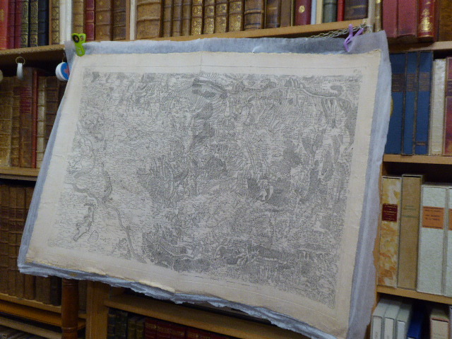
CASSINI
CARTE GEOGRAPHIQUE. N°122 ( Fle. 122 ). Provence - Comtat Venaissin...
S.N. S.L. 1780 Importante carte géographique de CASSINI ( 600 X 900 mm à la cuvette ), gravée en noir, imprimée sur papier fort et entoilée. Echelle de dix mille toises. Bel état.
書籍販売業者の参照番号
: 365874
|
|
|
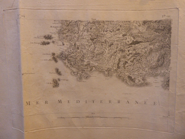
CASSINI
CARTE GEOGRAPHIQUE. N°124 ( Fle. 129 ). PROVENCE. Marseille.
S.N. S.L. 1780 Importante carte géographique de CASSINI ( 360 X 500 mm à la cuvette ), gravée en noir, imprimée sur papier fort et entoilée. Echelle de dix mille toises. Bel état.
書籍販売業者の参照番号
: 466164
|
|
|
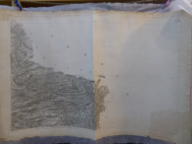
CASSINI
CARTE GEOGRAPHIQUE. N°166 ( Fle. 147 ). PROVENCE. VIGUERIE DE GRASSE. Comté de Savoye...
S.N. S.L. 1780 Importante carte géographique de CASSINI ( 600 X 900 mm à la cuvette ), gravée en noir, imprimée sur papier fort et entoilée. Echelle de dix mille toises. Bel état.
書籍販売業者の参照番号
: 25095
|
|
|
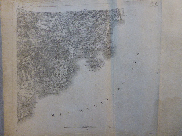
CASSINI
CARTE GEOGRAPHIQUE. N°167 ( Fle. 148 ). PROVENCE. VIGUERIE DE DRAGUIGNAN. Iles de Leirins...
S.N. S.L. 1780 Importante carte géographique de CASSINI ( 600 X 650 mm à la cuvette ), gravée en noir, imprimée sur papier fort et entoilée. Echelle de dix mille toises. Bel état.
書籍販売業者の参照番号
: 610329
|
|
|
CASSINI
CARTE GEOGRAPHIQUE. N°92 ( Fle. 116 ). PROVENCE. LANGUEDOC. Isle de la Camargue...
S.N. S.L. 1780 Importante carte géographique de CASSINI ( 600 X 900 mm à la cuvette ), gravée en noir, imprimée sur papier fort et entoilée. Echelle de dix mille toises. Bel état.
書籍販売業者の参照番号
: 24094

|
|
|
Cassini
Carte générale de la France N° 92. Montpellier. Languedoc. Isle de la Camargue.
français Slnd. 70 x 100 cm. Echelle de dix mille toises. Impression en noir, tirage sur beau papier.
|
|
|
Cassity Turner James Atlas Stephen Berg
POETRY Vol. 116 CXVI - No. 4 July 1970
Modern Poetry Assn. Fair. 1970. Softcover. Fair blue paperback with LIBRARY stamp and number on the front cover. Heavily bumped at the top corner. Pages 211-268 text unmarked. Turner Cassity: The Airship Boys in Africa. James Atlas: Voyager. Stephen Berg: Transparencies. ; C Poe; 8vo 8" - 9" tall . Modern Poetry Assn. paperback
書籍販売業者の参照番号
: 30651
|
|
|
Cassity Turner; James Atlas
Poetry Magazine July 1970
1970. Near fine in wrappers xwith light stamp to front panel. 13 poems by Cassity and book review by Atlas of "Voyager: A Biography of Hart Crane" by John Unterecker. First Edition. Soft Bound. Near Fine. Paperback
書籍販売業者の参照番号
: 014855
|
|
|
CASTANY G
MONOGRAPHIES REGIONALES. TUNISIE. 6. ATLAS TUNISIEN ORIENTAL ET SAHEL
Tunis 1952. In-8 broché, de 152 pages + cartes dépliantes. Figures dans le texte. Signature et cachet d'appartenance. XIX ème congrès géologique international.
|
|
|
CASTELLAN
Mœurs, usages, costumes des Othomans, et abrégé de leur histoire. La culture turque en 72 planches coloriées à la main à l’époque.
La culture turque en 72 planches coloriées à la main à l’époque. Paris, Nepveu, 1812.6 volumes in-16 de I/ 20 pp., xxxi pp. (1) p., 119 pp., (1) p. de table, 1 planche hors-texte ; II/ (2) ff., 225 pp., (1) p., (1) f. de table, 1 planche hors-texte ; III/ (2) ff., 251 pp. (1) p. de table, 16 planches hors-texte ; IV/ (2) ff., 282 pp., (1) f. de table, 17 planches hors-texte ; V/ (2) ff., 231 pp., (1) p. de table, 10 planches hors-texte ; VI/ (2) ff., 235 pp., (3) pp, 27 planches hors-texte. Relié en plein maroquin rouge à grain long, roulette dorée d’encadrement sur les plats, dos lisses richement ornés, roulette dorée sur les coupes, roulette intérieure dorée, tranches dorées. Reliure de l’époque signée R. P. Chilliat.134 x 82 mm.
書籍販売業者の参照番号
: LCS-17318

|
|
|
Castelnovi, Michele
Il primo atlante dell'impero di mezzo. Il contributo di Martino Martini alla conoscenza geografica della Cina
[Cina Asia Geografia](cm. 24)Bossura editriale fig a colori. -pp. 173 L'opera geografica di Martino Martini rappresentò una svolta nella conoscenza della Cina perché frutto, per la prima volta, di studio diretto delle fonti cinesi e di ricerche effettuate sul campo da un missionario che conosceva bene la lingua mandarina e poteva dialogare con tutti. Martino Martini, gesuita trentino, nel 1655 offrì all'Europa una grande descrizione cartografica e geografica dell'estremo oriente, basandosi oltre che sull'esperienza, sui trattati in lingua cinese. Per evitare che le sue infrmazioni sparissero con il tempo, si affidò al maggior editorre dell'eopoce, Blaeu Joan di Amsterdam. Dopo 350 anni dalla morte del Martini, Castelnovi, esamina i ruolo del NOVUS ATLAS SINENSIS nella cartografia europea. Usuali segni d'uso alla brossura, erfetto all'interno. [n45] Libro

|
|
|
Castiglioni, Manlio [Hrsg.]
Internationaler Atlas. The international atlas. Neuaufl.
Bern : Kümmerly u. Frey; Chicago : Rand McNally; Braunschweig : Westermann, 1987. XV, 288, 232 S., überwiegend Kt. Kunststoff, gebundene Ausgabe.
書籍販売業者の参照番号
: 99288

|
|
|
CASTILLON DU PERRON Marguerite
CHARLES DE FOUCAULD
Grasset Grasset 1982, In-8 broché, 521 pages. Bon état.
書籍販売業者の参照番号
: 9996820
|
|
|
CASTILLON DU PERRON Marguerite
CHARLES DE FOUCAULD
Grasset 1982, In-8 broché, 521 pages. Bon état.
|
|
|
Catherine F. Sullivan Courtney Atlas
Health Care Food Service Systems Management
Jones & Bartlett Publishers. Used - Very Good. Ships from Reno NV. Great condition for a used book! Minimal wear. 100% Money Back Guarantee. Shipped to over one million happy customers. Your purchase benefits world literacy! Jones & Bartlett Publishers unknown
書籍販売業者の参照番号
: GRP105896678 ISBN : 0834209217 9780834209213

|
|
|
Catherine F. Sullivan Courtney Atlas
Health Care Food Service Systems Management
Jones & Bartlett Publishers. Used - Good. Shows some signs of wear and may have some markings on the inside. Jones & Bartlett Publishers unknown
書籍販売業者の参照番号
: GRP10061128 ISBN : 0834209217 9780834209213
|
|
|
CATHERINE SULLIVAN COURTNEY ATLAS
HEALTH CARE FOOD SERVICE SYSTEMS MANAGEMENT
Aspen 1998-01-15. 3. Paperback. Used:Good. Aspen paperback
書籍販売業者の参照番号
: DADAX0834209217 ISBN : 0834209217 9780834209213
|
|
|
Catherine F. Sullivan Courtney Atlas
Health Care Food Service Systems Management
Jones & Bartlett Publishers. Used - Very Good. Former Library book. Great condition for a used book! Minimal wear. Jones & Bartlett Publishers unknown
書籍販売業者の参照番号
: GRP25493150 ISBN : 0834209217 9780834209213
|
|
|
CAUMONT (Marquis de).
Cours d'antiquités monumentales professé à Caen. Histoire de l'art dans l'ouest de la France depuis les temps les plus reculés jusqu'au XVIIe siècle. Atlas.
1830 demi-rel. in-4 à l'italienne, (2ff.), 106 planches, Paris Lance 1830,
書籍販売業者の参照番号
: 4720
|
|
|
Cauët René & Serryn Pierre & Vincent Marc
Petit atlas bordas La France, le monde.
Bordas. 1969. In-4. Relié. Etat d'usage, Tâchée, Coiffe en tête abîmée, Intérieur frais. Environ 25 pages d'index + 48 cartes en couleurs.. . . . Classification Dewey : 912-Atlas, cartes et plans
書籍販売業者の参照番号
: R320153669

|
|
|
CAYETANO ENRIQUEZ DE SALAMANCA
CARTE: LA SIERRA DE GUARA 1:50.000
CAYETANO ENRIQUEZ DE SALAMANCA. 1983. In-8. Broché. Etat d'usage, Couv. légèrement passée, Dos satisfaisant, Intérieur frais. Carte au 1:50.000ème. 96 x 66cm. Carte illustrée en couleurs. Photo illustrée en couleurs. Texte et nombreuses photos en noir et blanc au dos. Texte en espagnol.. . . . Classification Dewey : 912-Atlas, cartes et plans
書籍販売業者の参照番号
: R260105861
|
|
|
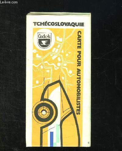
CEDOK.
CARTE POUR AUTOMIBILISTES. TCHECOSLOVAQUIE.
CHEZ L AUTEUR.. 1971. In-Plano. Broché. Bon état, Couv. convenable, Dos satisfaisant, Intérieur acceptable. Carte dépliante en couleurs.. . . . Classification Dewey : 912-Atlas, cartes et plans
書籍販売業者の参照番号
: R150173727
|
|
|
CEDOK.
CARTE POUR AUTOMIBILISTES. TCHECOSLOVAQUIE.
CHEZ L AUTEUR.. 1971. In-Plano Carré. Broché. Bon état. Couv. convenable. Dos satisfaisant. Intérieur acceptable. Carte dépliante en couleurs.

|
|
|
Celestial Atlas. Burritt E. H
Atlas designed to illustrate the geography of the heavens : comprising the following maps
Hartford: F.J. Huntington 1833. Original wraps folio. Maps are hand colored engravings by Illman & Pilbrow after the author's drawings. Some staining and wear a good unsophisticated copy. First edition of what would become a immensely popular work. The true first as here is quite scarce. American Imprints 18047. F.J. Huntington unknown
書籍販売業者の参照番号
: kfk549
|
|
|
CELLARIUS (Christophe)
Notitia Orbis Antiqui sive Geographia Plenior ab Ortu Rerumpublicarum ad Constantinorum tempora Orbis terrarum faciem declarans… et Novis Tabulis Geographicis… adjectus est Index copiosissimus delineatis & aliarum rerum Geographicarum.
Lipsiae Gleditsch Senioris 1701-1706 basane époque à restaurer. 2 fort in-4, portrait, (8ff.), 1332pp., (32ff.) et (8ff.), 889pp. (1f.), 254pp., (31ff.), XXXIV cartes repl. sur cuivre,
書籍販売業者の参照番号
: 11847
|
|
|
Cellarius, Andreas
Harmonia macrocosmica of 1660. The finest atlas of the heavens / Der prächtigste Himmelsatlas / L'atlas céleste le plus admirable. German transl.: Brigitte Beier ... French transl.: Daniel Roche ... Engl. transl.: Jennifer Schaudies ....
[Braunschweig, Archiv Verlag, 2006]. 240 S. Mit 27 Textabb. und sehr zahlr. Farbkarten. 54 cm. Schwarzes, goldgeprägtes Kunstleder mit Ganzgoldschnitt und Lesebändchen.
書籍販売業者の参照番号
: 91914

|
|
|
Cellarius, Andreas
Harmonia macrocosmica seu atlas universalis et novus, totius universi creati cosmographiam generalem, et novam exhibens. Reproduktion der Ausgabe Amsterdam, J. Janssonius, 1661 Reproduktion nach dem Exemplar der Universitäts- und Landesbibliothek Darmstadt, Sign. gr. Fol. 3/497a. Im Anhang Kommentar von Jürgen Hamel "Andreas Cellarius: Die Harmonie der großen Welt. Harmonia Macrocosmica.
Berlin, Coron bei Kindler Verlag 2006. Mit 29 doppelblattgroßen farbige Karten + 39 Seiten Kommentar., Gr.-Folio. braunes goldgeprägtes illustriertes OLeder mit 9 Bünden und gepunztem Vollgoldschnitt.,
書籍販売業者の参照番号
: 95932

|
|
|
CEPEDA, Fernando de / CARRILLO, Fernando Alfonso
Relacion Universal legitima, y verdadera del sitio en que esta fundada la muy noble, insigne, y muy leal Ciudad de Mexico, cabeça de las Provincias de toda la Nueva Espana. Lagunas, Rios, y Montes que la cinen y rodean. Calçadas que las dibiden. Y Azequias que la atraviesan. Ynundaciones que à padecido desde su Gentilidad. Remedios aplicados. Desagues propuestos, y emprendidos. Origen y fabrica del de Gueguetoca, y estado en que oy se halla. Ymposiciones, derramas, y gastos que se an hecho. Forma con que se a auctuado desde el ano de 1553 hasta el presente de 1637. [Avec la suite]. Ouvrage « précieux pour l’histoire de Mexico ».
Très rare édition originale de cet ouvrage « précieux pour l’histoire de Mexico ». Mexico, 1637. Mexico, Francisco Salbago, 1637. 4 parties reliées en 1 volume in-folio de (2) ff., 31 ff., 41 ff. (chiffrés par erreur 42), 41 ff. chiffrés 1 à 28 puis 29 à 39 (les ff. 17-18 sont répétés), (1) f., 11 ff. Exemplaire complet. Relié en veau brun, dos lisse orné, gardes renouvelées, tranches rouges. Charnières frottées. Reliure de l’époque.278 x 196 mm.
書籍販売業者の参照番号
: LCS-785

|
|
 検索結果のメールを受信する
 PDFファイルの検索結果をダウンロード
 RSSフィード


