|
Jaillot,Sanson Guillaume
Carte : La seigneurerie d'Utrecht dressé par le Sr. Sanson Géographe Ordinaire du Roy à Paris chez H. Jaillot
Jaillot H. Carte 1675 Carte de 41 x 56 cm en une partie : frontières colorées ; petits défauts, très bon exemplaire. Livraison a domicile (La Poste) ou en Mondial Relay sur simple demande.
Bookseller reference : bb3400
|
|
|
Jaillot,Sanson Guillaume
Carte : Le duché de Berg, le comté de Homberg, les seigneuries de Hardengberg et de Wildenborg dressé sur les mémoires les plus récents par le Sr. Sanson géographe ordinaire du Roy
Jaillot H. Carte 1695 Carte de 43 x 57 cm en une partie : frontières colorées ; petites déchirures marginales sans gravité, bon exemplaire. Livraison a domicile (La Poste) ou en Mondial Relay sur simple demande.
Bookseller reference : bb3406
|
|
|
Jaillot,Sanson Guillaume
Carte : Le marquisat et l'eslectorat de Brandebourg qui fait parti du cercle de la haute Saxe divisé en ses parties principales parties par le Sr. Sanson, géographe ordinaire du Roy
Jaillot H. Carte 1676 Cartes en deux parties, 53 par 90 cm ; frontières surlignées en couleur, très bel exemplaire. Livraison a domicile (La Poste) ou en Mondial Relay sur simple demande.
Bookseller reference : bb3407
|
|
|
Jaillot,Sanson Guillaume
Carte : La seigneurerie d'Utrecht dressé par le Sr. Sanson Géographe Ordinaire du Roy à Paris chez H. Jaillot
Jaillot H. Carte 1675 Carte de 41 x 56 cm en une partie : frontières colorées ; petits défauts, très bon exemplaire. Livraison a domicile (La Poste) ou en Mondial Relay sur simple demande.
Bookseller reference : ag657
|
|
|
Jaillot,Sanson Guillaume
Carte : Partie orientale du Palatinat et eslectorat du Rhein, les évéchés de Spire, de Wormes et le comté de Linange tiré des mémoires les plus nouveaux par le Sr. Sanson géographe ordinaire du Roy
Jaillot H. Carte 1674 Cartes en une partie, 42 par 56 cm ; frontières surlignées en couleur, mouillures marginales, n'atteignant pas la carte, bel exemplaire. Livraison a domicile (La Poste) ou en Mondial Relay sur simple demande.
Bookseller reference : ag658
|
|
|
Jaillot,Sanson Guillaume
Carte : Le duché de Berg, le comté de Homberg, les seigneuries de Hardengberg et de Wildenborg dressé sur les mémoires les plus récents par le Sr. Sanson géographe ordinaire du Roy
Jaillot H. Carte 1695 Carte de 43 x 57 cm en une partie : frontières colorées ; petites déchirures marginales sans gravité, bon exemplaire. Livraison a domicile (La Poste) ou en Mondial Relay sur simple demande.
Bookseller reference : ag659
|
|
|
Jaillot,Sanson Guillaume
Carte : Le marquisat et l'eslectorat de Brandebourg qui fait parti du cercle de la haute Saxe divisé en ses parties principales parties par le Sr. Sanson, géographe ordinaire du Roy
Jaillot H. Carte 1676 Cartes en deux parties, 53 par 90 cm ; frontières surlignées en couleur, petites déchirures marginales, bel exemplaire. Livraison a domicile (La Poste) ou en Mondial Relay sur simple demande.
Bookseller reference : ag661
|
|
|
Jaillot,Sanson Guillaume
Carte : Basse partie de l'évéché de Munster et le comté de Benthem tiré des mémoires les plus récents, par le Sr. Sanson géographe ordinaire du Roy
Jaillot H. Carte 1674 Carte de 43 x 57 cm en une partie : frontières colorées ; petites déchirures marginales sans gravité, bon exemplaire. Livraison a domicile (La Poste) ou en Mondial Relay sur simple demande.
Bookseller reference : ag662
|
|
|
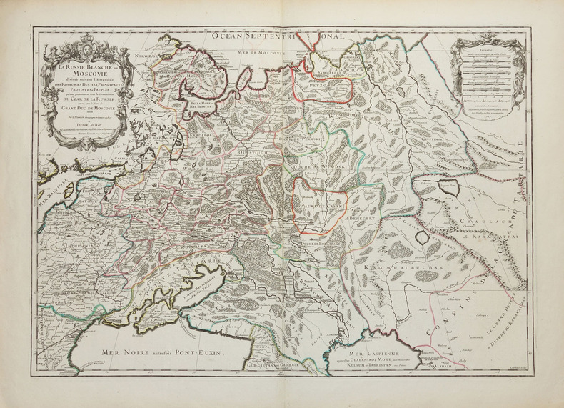
JAILLOT (Alexis-Hubert) & SANSON d'ABBEVILLE (Nicolas).
La Russie blanche ou Moscovie divisée suivant l'estendüe des royaumes, duchés, principautés, provinces et peuples qui sont présentement sous la domination du Czar de Russie, connû sous le nom de grand duc de Moscovie.
Paris, H. Jaillot, 1717. 450 x 645 mm.
Bookseller reference : LBW-2261
|
|
|
Jaillot,Sanson Guillaume
Partie orientale du temporel, de l'archevesché et l'eslectorat de Treves tiré des mémoires les plus nouveaux par le Sr. Sanson, géographe ordinaire du Roy à Paris Chez Jaillot
Jaillot H. Carte 1674 Carte de 42 x 55 cm en une partie : frontières colorées ; très bon exemplaire. Livraison a domicile (La Poste) ou en Mondial Relay sur simple demande.
Bookseller reference : bb3401
|
|
|
Jaillot,Sanson Guillaume
Partie occidentale du Palatinat et eslectorat du Rhein, le Duché de Simmeren, lmes comtés de Spanheim et de Veldentz à la maison Palatine où sont encore les comtés de Rheingravenstein, de Falkenstein, et la baronnie de Reipoltzkirch
Jaillot H. Carte 1674 Carte de 43 x 57 cm en une partie : frontières colorées ; mouillure marginale sans gravité, bon exemplaire. Livraison a domicile (La Poste) ou en Mondial Relay sur simple demande.
Bookseller reference : bb3404
|
|
|
Jaillot,Sanson Guillaume
Partie occidentale du Palatinat et eslectorat du Rhein, le Duché de Simmeren, lmes comtés de Spanheim et de Veldentz à la maison Palatine où sont encore les comtés de Rheingravenstein, de Falkenstein, et la baronnie de Reipoltzkirch
Jaillot H. Carte 1674 Carte de 43 x 57 cm en une partie : frontières colorées ; mouillure marginale sans gravité, bon exemplaire. Livraison a domicile (La Poste) ou en Mondial Relay sur simple demande.
Bookseller reference : ag660
|
|
|
JAILLOT Alexis Hubert & SANSON Nicolas
L'Empire d'Allemagne distingue suivant l'etendue de Touts les Estats Principautes et Souverainetes qui passent ou qui ont passe jusque a present sous le nom d'Allemagne
Amsterdam: Alexis-Hubert Jaillot 1696. unbound. very good. Map. Engraving with hand outline. Image measures 23" x 35".<br/><br/> Stunning map showing the vast extent of the German Empire including parts of Poland Bohemia Hungary Austria Croatia Italy France and the Netherlands. Exquisite and subtle coloring beautifully detailed. Based on a plate by Nicolas Sanson reworked and published in "Atlas Nouveau" by Jaillot. Severe toning due to early acid backing chipping to edges and corners and some tears. Priced as is. Alexis-Hubert Jaillot 1632--1712 was a French sculptor engraver publisher and cartographer. He served as official geographer to King Louis XIV and worked with other prominent mapmakers of the period such as Nicolas Sanson He is best known for his Atlas Nouveau of 1674.<br/><br/> Alexis-Hubert Jaillot unknown books
Bookseller reference : 206066

|
|
|
JAILLOT Alexis Hubert 1632 1712 after Nicolas SANSON 1600 1667
Normandy Le Duché et Gouvernement de Normandie divisée en Haute et Basse Normandie en divers Pays; et par evêchez avec le Gouvernement General du Havre de Grace
Paris: Alexis Hubert Jaillot 1696. Copper-engraved map with full original colour and gold embellishment in excellent condition. A stunning map of Normandy by Alexis Jaillot an exceptional example with gilt embellishments.<br/> <br/>One of the most important figures in French cartography Nicolas Sanson initiated the great school of French geographers. Born in Abbeville in 1600 Sanson established his first printing house in Paris in 1638. He soon became geographer to the king establishing himself as one of the most influential cartographers on the Continent. He was succeeded by his sons Adrien and Guillaume and by his son-in-law Pierre Duval who continued to publish a wealth of maps using Sanson's name. At the close of the seventeenth century Sanson's plates were purchased by the influential cartographer Alexis Hubert Jaillot who continued to publish his maps and atlases under Sanson's title. This stunning map of Normandy is based on Sanson's map published in 1650 but was redrawn and enlarged by Jaillot. It shows the provinces of Normandy as well as the northern tip of Brittany and part of the English Channel. Both Jersey and Guernsey are included as is Mont St. Michel off the coast of St. Malo. In keeping with all of Sanson's and Jaillot's superb maps forests rivers and towns are meticulously identified and named. The map includes an ornate cartouche in the upper section as well as a scale and key.<br/> <br/>Tooley Maps & Map-Makers pp. 40-41. Alexis Hubert Jaillot unknown books
Bookseller reference : 16269

|
|
|
JAILLOT, [Alexis] H[ubert]. [After] SANSON, [Nicolas d'Abbeville].
La Flandre Françoise .
Paris: Jaillot. 1689. 43.1 x 57 cm. Original outline colour. Single page folio map of southern Flanders and Artois. Blank on verso. Small tear without loss at upper edge just touching image. Small section of upper margin missing though not affecting map. Small brown spot to centre of lower edge. Paris: Jaillot. 1689 unknown
Bookseller reference : 30600
|
|
|
JAILLOT, [Alexis] H[ubert]. [After] SANSON, [Nicolas d'Abbeville].
Le Limbourg ou sont Le Duche De Limbourg Le Comté De Dalem; Les Seigneuries De Fauquemont Et De Rolduc .
Paris: Jaillot. 1681. 43 x 57 cm. Original outline colour. Single page folio map of Limborg and its envirions. Blank on verso. Small tear with loss to upper right margin. Some light stains at right margin though not affecting image otherwise in very good condition. Paris: Jaillot. 1681 unknown
Bookseller reference : 30597
|
|
|
Jaillot, Alexis Hubert ; Nicolas Sanson
ESTATS DE L'EMPIRE DES TURQS EN EUROPE.
Paris: Chez H. Jaillot 1692. First edition thus. Map. Good/No jacket as issued. Large double page copper engraved map 23" x 34 1/2". Contains wide margins and a decorative cartouche. Hand-colored boundaries and cartouche. General age-toning with minor browning. Nicely framed in modern rope effected matte gold frame 32" x 42" with gilt bordered white mat and acrylic glaze. A good copy of this scarce map. All text in French Printed just 9 years after the Ottomans besieged Vienna. Extra shipping may apply for foreign orders. Chez H. Jaillot unknown
Bookseller reference : 001000
|
|
|
JAILLOT, Alexis-Hubert & SANSON, Nicolas
L'Empire d'Allemagne distingue suivant l'etendue de Touts les Estats Principautes et Souverainetes qui passent ou qui ont passe jusque a present sous le nom d'Allemagne
Amsterdam: Alexis-Hubert Jaillot 1696. unbound. very good. Map. Engraving with hand outline. Image measures 23" x 35".<br/> <br/> Stunning map showing the vast extent of the German Empire including parts of Poland Bohemia Hungary Austria Croatia Italy France and the Netherlands. Exquisite and subtle coloring beautifully detailed. Based on a plate by Nicolas Sanson reworked and published in "Atlas Nouveau" by Jaillot. Severe toning due to early acid backing chipping to edges and corners and some tears. Priced as is. Alexis-Hubert Jaillot 1632--1712 was a French sculptor engraver publisher and cartographer. He served as official geographer to King Louis XIV and worked with other prominent mapmakers of the period such as Nicolas Sanson He is best known for his Atlas Nouveau of 1674.<br/> <br/> Alexis-Hubert Jaillot unknown
Bookseller reference : 206066
|
|
|
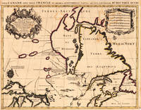
Jaillot, Alexis-Hubert & Sanson, N.
Le Canada Ou Partie De La Nouvelle France Dans lÂ’ Amerique Septentrionale Contenant la Terre de Labrador la Nouvelle France les Isles de Terre Neuve de Nostre Dame etc. aÂ’ lÂ’ Usage de Monseigneur Le Duc De Bourgogne. Par son tres humble. Hubert Jaillot.
Paris: Hubert Jaillot. 1693. Other. In excellent condition. Minor offsetting of the old outline colors to the paper. 465 by 610mm 18¼ by 24 inches. 465 by 610mm 18¼ by 24 inches. Copper-engraving handcolored in outline when published. Printed around 1693 by Hubert Jaillot in Paris published in his great atlas the ‘Atlas Noveau.’. Large and decorative map of Canada by the French cartographer Nicolaus Sanson and Hubert Jaillot. Published in the 'Atlas Noveau.' this atlas was a masterpiece in the French cartography in the 17th century. The atlas was specially designed for Louis XIV and due of the very large size of the plates most maps were printed from two plates it took Hubert Jaillot over 12 years to complete the 'Atlas Noveau.'. Canada is very detailled shown on the map as well Labrador Terra Neuf & Nouvelle France are shown in engraved territory borders. The map is rich in detail with many cities and place names rivers lakes mountains bays etc. Hubert Jaillot. unknown
Bookseller reference : 17230
|
|
|
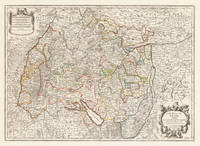
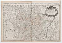
Jaillot, Alexis-Hubert & Sanson, N.
Le Cercle de Souabe subdivisé en tous les Estats qui le Composent Tire ´sur les Memoires les plus noueaux Par le S. Sanson Geographe Ordinaire du Roy. A Paris Ches H. Laillot joingnant les Augustins aux deux Globes Auec Priuilege du Roy pour Vingt Ans.
Paris: Hubert Jaillot 1710. In ausgezeichnetem Zustand. 803 by 560mm 31½ by 22 inches. Kupferstichkarte in zeitgenössischem Grenzkolorit. Mit großer prächtiger allegorischer Kartusche sowie Meilenzeiger mit Legende. Erschienen im großen AtlasAtlas Nouveau contenant.Â’ von Nicolaus Sanson u. Hubert Jaillot. Dargestellt wird der schwäbische Kreis im Norden mit dem benachbarten Franken u. im Süden bis zum Bodensee. Im Osten noch mit Teilen von Bayern der Westen mit dem angrenzenden Frankreich. Das Kartenbild sorgfältig u. übersichtlich ausgearbeitet. Der Atlas Nouveau.Â’ entstand als Auftragsarbeitet für Ludwig XIV. und nahm einen Zeitraum von über 10 Jahren in Anspruch. Die Karten gelten bis heute noch als eine Meisterleistung der französischen Kartographie des 17.Jahrhunderts. Als Geburtsjahr Jaillots wird das Jahr 1632 angenommen da in seiner Sterbeurkunde sein Alter mit 80 Jahren angegeben war. Der Geburtsort war Avignon-lès-Saint-Claude damals ein kleiner Weiler in der Exklave der Freigrafschaft Burgund die dazu gehörte Spanisches Königreich. Jaillot hatte seit seiner Kindheit ein großes Talent für Kunst und Design. Bildhauerei lernte er bei seinem Bruder Pierre-Simón. Als Folge der französisch-spanischen Konflikte wurde ihre Heimatstadt verwüstet und so gingen die beiden Brüder 1657 nach Paris. Dort erlangten sie bald einen gewissen Ruf und den Titel „Sculpteur du Roy“. 1665 heiratete Jaillot in die Kartenverlegerfamilie Berey ein. Nach dem Tod seines Schwagers Nikolaus II. Berey 1640–1667 kaufte er die Berey-Kartensammlung von seiner Schwägerin. Dadurch erhielt er eine wertvolle Grundlage die er sofort vermarkten konnte ohne jemals selbst eine Karte erstellt zu haben. Jaillot stieg zu einem günstigen Zeitpunkt in das Kartengeschäft ein. Anfang 1668 gewann Ludwig XIV. den ersten seiner Réunionskriege und es begann eine Zeit in der Frankreich sein Territorium kontinuierlich erweiterte. Es entwickelte sich eine große Nachfrage nach Karten die die französischen Triumphe und die neuen Grenzen sowie bevorstehende Expansionspläne darstellten.Zu Jaillots Kartensammlung gehörten auch Druckplatten die von Pierre Duval 1619–1683 Neffe von Nicolas Sanson erstellt und ursprünglich an Nicolas Berey verkauft wurden. Doch Duval der auch seine eigenen Karten veröffentlichte weigerte sich seine alten Karten nachzudrucken. Auf dem Höhepunkt des Streits mit Duval rekrutierte Jaillot Ende 1670 Nicolas Sansons Söhne Guillaume und Adrien als Kartenmacher und Geschäftspartner. Mit ihnen konnte er neue Karten mit dem prestigeträchtigen Namen Sansons vermarkten. Sein erster Atlas aus dem Jahr 1681 Atlas Nouveau wurde ein so großer kommerzieller Erfolg dass andere Verlage begannen plagiierte Kopien zu verbreiten.Jaillot bemühte sich um königliche Schirmherrschaft und widmete viele seiner Kartenausgaben dem König. Schließlich wurde er am 20. Juli 1686 zum Géographe du Roy ernannt und erhielt eine jährliche Rente von 600 Livres. Dieser Titel sowie die protektionistische und kontrollierende Gesetzgebung ermöglichten es ihm sich erfolgreich gegen seine Plagiatoren zu wehren.Seit dem frühen 18. Jahrhundert gab Jaillot immer weniger Karten aus. Die Nachfrage nach zeitnah aktualisierten Karten nahm zu und er war immer weniger in der Lage auf die Anforderungen des Marktes zu reagieren. Jüngere Konkurrenten waren gut ausgebildete Geographen wie Guillaume Delisle die die Kartierung selbst durchführen konnten. Im Laufe der Zeit übergab Jaillot das Geschäft an seinen Sohn Bernard Jean-Hyacinthe.Alexis Hubert Jaillot starb am 2. November 1712 im Alter von 80 Jahren in Paris. Er wurde im Convent des Grands-Augustins beigesetzt. WikipediaNicolas Sanson der Ältere 20. Dezember 1600 in Abbeville Frankreich; † 7. Juli 1667 in Paris war ein französischer Kartograph. Seine Vorfahren stammten aus Schottland. Zwischen 1618 und 1667 schuf Sanson rund 300 Einzelkarten sowie Atlanten und illustrierte Texte.Seine Arbeit wurde von seinen Söhnen Nicolas Sanson 1626 Schottland; † 27. August 1648 in Paris Adrien Sanson † 1708 und Guillaume Sanson † 1703 seinem Neffen Pierre Duval 1619; † 1683 ausgeführt. sein Enkel Pierre Moulard Sanson † 1730 und Gilles Robert de Vaugondy 1688; † 1766 führten weiter. Wikipedia Hubert Jaillot unknown
Bookseller reference : 37419
|
|
|
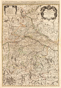
Jaillot, Alexis-Hubert & Sanson, N.
Le Cours de la Riviere du Rhein depuis sa Source jusques a son Emboucheure ou sont distingues Tout les Estats et Souverainetes qui sont dessus et aux enuirons. Tire de tous les Memoires les plus Nouveaux Parle Sr. Sanson Geopgraphe Ordinaire du Roy
Paris 1692. Other. Schönes tadelloses Exemplar. . 803 by 560mm 31 by 22 inches. Kupferstichkarte in zeitgenössischem Grenzkolorit. Mit großer prächtiger allegorischer Kartusche sowie Meilenzeiger mit Legende. Erschienen im großen Atlas Atlas Nouveau contenant. von Nicolaus Sanson u. Hubert Jaillot. Dargestellt wird der Bereich Das Kartenbild sorgfältig u. übersichtlich ausgearbeitet. Der Atlas Nouveau. entstand als Auftragsarbeit für Ludwig XIV. und nahm einen Zeitraum von über 10 Jahren in Anspruch u. gelten bis heute noch als eine Meisterleistung der franz. Kartographie des 17. Jahrhunderts. Der Abdruck der Karte durchwegs kräftig u. klar. Alexis Hubert Jaillot ca. 1632 in Avignon-lès-Saint-Claude Freigrafschaft Burgund; † 2. November 1712 in Paris war ein bedeutender französischer Kartograph und Verleger. Alexis Hubert Jaillot wurde circa 1632 in Avignon-lès-Saint-Claude geboren. Seine Eltern waren Jean Jaillot und Etiennette Fournier. Sein Bruder war Pierre-Simón 1631–23. September 1681. Jaillot heiratete am 11. Januar 1665 Jeanne Berey † 1. November 1675 die Tochter des Graveurs und Kartenverlegers Nicolas I Berey 1610–1665 aus Paris. Aus dieser Ehe gingen sieben Kinder hervor darunter François Hubert-Joseph 1671 und Bernard Jean-Hyacinthe 11. Februar 1673–1739. Nach dem Tod seiner ersten Frau heiratete er am 26. Abril 1676 Charlotte Orbane. Aus dieser Ehe gingen acht Kinder hervor darunter Charles-Hubert 1678. Als Jaillots Geburtsjahr wird 1632 angenommen weil in der Sterbeurkunde sein Alter mit 80 Jahren angegeben wurde.1 Der Geburtsort war Avignon-lès-Saint-Claude damals ein kleiner Weiler in der zum spanischen Königreich gehörenden Exklave Freigrafschaft Burgund. Schon seit seiner Kindheit hatte Jaillot ein gutes Talent für Künste und Gestaltung. Von seinem Bruder Pierre-Simón lernte er die Bildhauerei. Infolge französisch-spanischer Auseinandersetzungen wurde ihr Heimatort verwüstet und so gingen die beiden Brüder 1657 nach Paris. Dort erwarben sie sich bald eine gewisse Reputation und den Titel Sculpteur du Roy. 1665 heiratete Jaillot in die Kartenverleger-Familie Berey ein. Nach dem Tod seines Schwagers Nicolas II Berey 1640–1667 kaufte er von der Schwägerin die Berey-Kartensammlung. So hatte er einen wertvollen Grundstock den er gleich vermarkten konnte ohne je selbst eine Karte hergestellt zu haben. Jaillot stieg in einem günstigen Moment in das Kartengeschäft ein. Anfang 1668 gewann Ludwig XIV. den ersten seiner Reunionskriege und es begann eine Zeit in der Frankreich sein Territorium ständig vergrößerte. Es entwickelte sich eine große Nachfrage nach Karten die die französischen Triumphe und die neuen Grenzen sowie anstehende Expansionsabsichten darstellten.Zu Jaillots Kartensammlung gehörten auch Druckplatten die Pierre Duval 1619–1683 Neffe von Nicolas Sanson erstellt und ursprünglich an Nicolas Berey verkauft hatte. Aber Duval der seine Karten auch selbst verlegte wehrte sich gegen die Neuauflage seiner alten Karten. Auf dem Höhepunkt der Auseinandersetzung mit Duval gewann Jaillot Ende 1670 die Söhne von Nicolas Sanson Guillaume und Adrien als Kartenmacher und Geschäftspartner. Mit ihnen konnte er neue Karten mit dem prestigeträchtigen Namen Sansons vermarkten. Sein erster Atlas von 1681 Atlas Nouveau wurde ein so großer kommerzieller Erfolg dass andere Verleger damit begannen Plagiate zu vertreiben.Jaillot suchte die königliche Patronage und widmete viele seiner Kartenauflagen dem König. Schließlich wurde er am 20. Juli 1686 zum Géographe du Roy ernannt und erhielt eine jährliche Pension von 600 Livres. Dieser Titel zusammen mit einer protektionistischen und kontrollierenden Gesetzgebung erlaubten ihm sich erfolgreich gegen seine Plagiatoren zu wehren.Seit dem frühen 18. Jahrhundert legte Jaillot immer weniger Karten auf. Es wurden immer mehr zeitnah aktualisierte Karten nachgefragt und es gelang ihm immer weniger auf die Anforderungen des Marktes zu reagieren. Jüngere Konkurrenten waren gut ausgebildete Geographen wie Guillaume Delisle die die Kartenerstellung selbst vornehmen konnten. Mit der Zeit gab Jaillot das Geschäft an seinen Sohn Bernard Jean-Hyacinthe ab.Alexis Hubert Jaillot starb am 2. November 1712 in Paris im Alter von 80 Jahren. Er wurde im Convent des Grands-Augustins beigesetzt. Wikipedia unknown
Bookseller reference : 28137
|
|
|
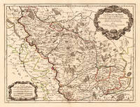
Jaillot, Alexis-Hubert & Sanson, N.
Le Duché de Berg le Comté de Homberg les Seigneuries de Hardenberg et de Wildenborg. Dressé surles Memoires les plus recents. Parle Sr. Sanson Geographe ordinaire du Roy. A Paris. Chez H. Iaillot joignant les grands Augustins aux deux Globes Aure Privilege du Roy. 1700.
Paris: H. Jaillot. 1700. Other. In excellent condition. 428 by 570mm 16¾ by 22½ inches. 428 by 570mm 16¾ by 22½ inches. Copper engraving hand colored in outline when published. Dekorative Karte des Herzogtum Berg mit dem Rhein und Erzbistum Köln als als westliche Begrenzung. Das Kartenbild zeigt detailliert das Herzogtum Berg mit vielen Ortsangaben gestochenen Bergen Flüßen Wäldern etc. Die politischen Grenzen werden durch zeitgenöss. Grenzkolorit dargestellt. Der französische Kartograph Nicolaus Sanson erreichte große Bekanntheit durch seine hervorragenden großformatigen kartographischen Erzeugnisse. Er schuf unter anderem den 'Atlas Nouveau.' welcher eine Auftragsarbeit für Ludwig XIV war. Viele der Karten in diesem Atlas waren doppelblattgroß und meistens von zwei Kupferplatten gedruckt. H. Jaillot. unknown
Bookseller reference : 24651
|
|
|
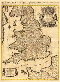
Jaillot, Alexis-Hubert & Sanson, N.
Le Royaume D’Angleterre distingué en ses Provinces. Par le Sr. Sanson. Geographe du Roy. Presenté A Monseigneur Le Dauphin. A Paris Chez H.Iaillot 1693.
Paris: H. Jaillot 1693. Other. In very good condition. 757 by 582mm 29¾ by 23 inches. 757 by 582mm 29¾ by 23 inches. Copper-engraving handcolored in outline when published. Minor offsetting of the old outline colors to the paper. Printed around 1693 by Hubert Jaillot in Paris printed from two plates and published in his great atlas the ‘Atlas Noveau.’. Large and decorative map of England by the French cartographer Nicolaus Sanson and Hubert Jaillot. Published in the 'Atlas Noveau.' this atlas was a masterpiece in the French cartography in the 17th century. The atlas was specially designed for Louis XIV and due of the very large size of the plates most maps were printed from two plates it took Hubert Jaillot over 12 years to complete the 'Atlas Noveau.'. England is very detailled shown on the map as well the various counties are shown in engraved territory borders. The maps are rich in detail with many cities and place names rivers mountains castles etc. The map is ornated with a very large fine allegoric title cartouche with coat of arms in the upper right corner as well a decorative cartouche with a milage scale in the lower left corner. H. Jaillot unknown
Bookseller reference : 17484
|
|
|
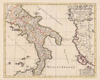
Jaillot, Alexis-Hubert & Sanson, N.
Le Royaume de Naples Divisé en Douze Provinces. sur les Memoires les plus Nouveaux. Par le Sr. Sanson Presenté A Monseigneur Le Dauphin Par son tres-humble Obeissant et tres fidele Serviteur H. Jaillot.
Paris: Hubert Jaillot 1696. Other. In excellent condition. 445 by 550mm 17½ by 21¾ inches. 445 by 550mm 17½ by 21¾ inches. Copper-engraving handcolored in outline when published. Printed around 1693 by Hubert Jaillot in Paris published in his great atlas the ‘Atlas Noveau.’. Large and decorative map of England by the French cartographer Nicolaus Sanson and Hubert Jaillot. Published in the 'Atlas Noveau.' this atlas was a masterpiece in the French cartography in the 17th century. The atlas was specially designed for Louis XIV and due of the very large size of the plates most maps were printed from two plates it took Hubert Jaillot over 12 years to complete the 'Atlas Noveau.'. The kingdom of Naples is very detailled shown on the map as well the various principalities are shown in engraved territory borders. The map is rich in detail with many cities and place names rivers mountains castles etc. The map is ornated with a large fine allegoric title cartouche with coat of arms in the upper right corner as well a decorative cartouche with a milage scale. Hubert Jaillot unknown
Bookseller reference : 17229
|
|
|
JAILLOT, Alexis Hubert (1632-1712), after Nicolas SANSON (1600-1667)
Normandy Le Duché et Gouvernement de Normandie divisée en Haute et Basse Normandie en divers Pays; et par evêchez avec le Gouvernement General du Havre de Grace
Paris: Alexis Hubert Jaillot 1696. Copper-engraved map with full original colour and gold embellishment in excellent condition. A stunning map of Normandy by Alexis Jaillot an exceptional example with gilt embellishments.<br/> <br/> One of the most important figures in French cartography Nicolas Sanson initiated the great school of French geographers. Born in Abbeville in 1600 Sanson established his first printing house in Paris in 1638. He soon became geographer to the king establishing himself as one of the most influential cartographers on the Continent. He was succeeded by his sons Adrien and Guillaume and by his son-in-law Pierre Duval who continued to publish a wealth of maps using Sanson's name. At the close of the seventeenth century Sanson's plates were purchased by the influential cartographer Alexis Hubert Jaillot who continued to publish his maps and atlases under Sanson's title. This stunning map of Normandy is based on Sanson's map published in 1650 but was redrawn and enlarged by Jaillot. It shows the provinces of Normandy as well as the northern tip of Brittany and part of the English Channel. Both Jersey and Guernsey are included as is Mont St. Michel off the coast of St. Malo. In keeping with all of Sanson's and Jaillot's superb maps forests rivers and towns are meticulously identified and named. The map includes an ornate cartouche in the upper section as well as a scale and key.<br/> <br/> Tooley Maps & Map-Makers pp. 40-41. Alexis Hubert Jaillot unknown
Bookseller reference : 16269
|
|
|
JAILLOT, H[ubert] after SANSON, [Nicolas].
La Lorraine qui comprend Les Duchés de Lorraine et de Bar et les Balliages des Eveschés et des Villes de Metz Toul et Verdun.
Paris: 1690. 54 x 87.5 cm. Double page copper engraved map of Lorraine. Original outline colour. Large decorative cartouche to upper right corner. Horizontal crease parallel and adjacent to centrefold otherwise good. [Paris:] 1690 unknown
Bookseller reference : 49665
|
|
|
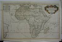
Jaillot, Sanson
L'Afrique divisee suivant l'estendue de ses principales parties. . .
Paris 1719. Excellent. Size : 580x890 mm 22.875x35 Inches Coloring: Original Outline Coloring Category: ; Maps Africa Continent unknown
Bookseller reference : M5162
|
|
|
Jaillot; Sanson
Chielafa
Paris c.1690. Very Good. Notes: Map of Chielafa Greece during the late 17th century. Size : 105x152 mm 4.13x5.98 Inches Coloring: Hand Colored Category: Maps Europe Greece Macedonia; unknown
Bookseller reference : M9479
|
|
|
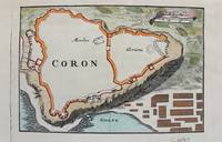
Jaillot; Sanson
Coron
Paris c.1690. Very Good. Notes: Map of Coron Greece during the late 17th century. Size : 103x153 mm 4.06x6.02 Inches Coloring: Hand Colored Category: Maps Europe Greece Macedonia; unknown
Bookseller reference : M9480
|
|
|
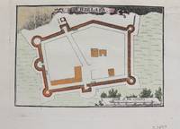
Jaillot; Sanson
F. D'Asso
Paris c.1690. Very Good. Notes: A charming map of Fort D'Asso Greece during the late 17th century. Size : 104x153 mm 4.09x6.02 Inches Coloring: Hand Colored Category: Maps Europe Greece Macedonia; unknown
Bookseller reference : M9473
|
|
|
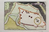
Jaillot; Sanson
Forteresse de Zante
Paris c.1690. Very Good. Notes: A charming map of Forteresse de Zante Greece during the late 17th century. Size : 104x154 mm 4.09x6.06 Inches Coloring: Hand Colored Category: Maps Europe Greece Macedonia; unknown
Bookseller reference : M9475
|
|
|
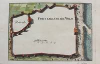
Jaillot; Sanson
Forteresse de Volo
Paris c.1690. Very Good. Notes: A charming map of Forteresse de Volo Greece during the late 17th century. Size : 104x153 mm 4.09x6.02 Inches Coloring: Hand Colored Category: Maps Europe Greece Macedonia; unknown
Bookseller reference : M9474
|
|
|
Jaillot; Sanson
La Ville D'Athenes
Paris c.1690. Very Good. Notes: A charming map of Athens Greece during the late 17th century. Size : 103x154 mm 4.06x6.06 Inches Coloring: Hand Colored Category: Maps City Maps; Maps Europe Greece Macedonia; unknown
Bookseller reference : M9477
|
|
|
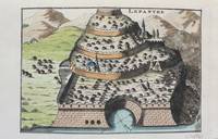
Jaillot; Sanson
Lepanthe
Paris c.1690. Very Good. Notes: A charming map of Lepanto Greece during the late 17th century. Size : 105x153 mm 4.13x6.02 Inches Coloring: Hand Colored Category: Maps Europe Greece Macedonia; unknown
Bookseller reference : M9478
|
|
|
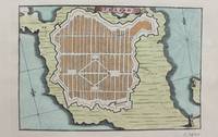
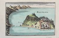
Jaillot; Sanson
Malvasia
Paris c. 1690. Very Good. Notes: A charming map of Malvasia Greece during the late 17th century. Size : 103x152 mm 4.06x5.98 Inches Coloring: Hand Colored Category: Maps Europe Greece Macedonia; unknown
Bookseller reference : M9577
|
|
|
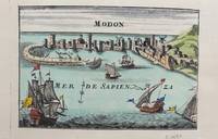
Jaillot; Sanson
Modon
Paris c. 1690. Very Good. Notes: A charming map of Modon Greece during the late 17th century. Size : 104x152 mm 4.09x5.98 Inches Coloring: Hand Colored Category: Maps Europe Greece Macedonia; unknown
Bookseller reference : M9578
|
|
|
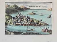
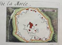
Jaillot; Sanson
Napoli de Romanie
Paris c. 1690. Very Good. Notes: A charming map of Nafplio Greece during the late 17th century. Size : 104x152 mm 4.09x5.98 Inches Coloring: Hand Colored Category: Maps Europe Greece Macedonia; unknown
Bookseller reference : M9576
|
|
|
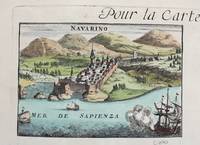
Jaillot; Sanson
Navarino
Paris c. 1690. Very Good. Notes: A charming map of Pylos Navarino Greece during the late 17th century. Size : 104x154 mm 4.09x6.06 Inches Coloring: Hand Colored Category: Maps Europe Greece Macedonia; unknown
Bookseller reference : M9579
|
|
|
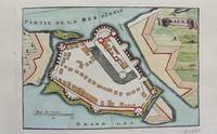
Jaillot; Sanson
Negropont
Paris c. 1690. Very Good. Notes: A charming map of Negroponte Chalcis Greece during the late 17th century. Size : 104x154 mm 4.09x6.06 Inches Coloring: Hand Colored Category: Maps Europe Greece Macedonia; unknown
Bookseller reference : M9575
|
|
|
Jaillot; Sanson
Passava
Paris c.1690. Very Good. Notes: Map of Passava Greece during the late 17th century. Size : 104x153 mm 4.09x6.02 Inches Coloring: Hand Colored Category: Maps Europe Greece Macedonia; unknown
Bookseller reference : M9481
|
|
|
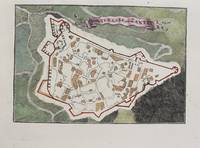
Jaillot; Sanson
Plan de Zarnata
Paris c.1690. Very Good. Notes: A charming map of Zarnata Greece during the late 17th century. Size : 103x152 mm 4.06x5.98 Inches Coloring: Hand Colored Category: Maps Europe Greece Macedonia; unknown
Bookseller reference : M9483
|
|
|
Jaillot; Sanson
S. Maura
Paris c.1690. Very Good. Notes: A charming map of Santa Maura on the island of Lefkada Greece during the late 17th century. <br><br> Size : 104x153 mm 4.09x6.02 Inches Coloring: Hand Colored Category: Maps Europe Greece Macedonia; unknown
Bookseller reference : M9472
|
|
|
James A. R Samson
Techniques of vacuum ultraviolet spectroscopy Wiley series in pure and applied spectroscopy
Wiley 1967. Hardcover. Acceptable. Missing dust jacket; Readable copy. Pages may have considerable notes/highlighting. ~ ThriftBooks: Read More Spend Less.Dust jacket quality is not guaranteed. Wiley hardcover
Bookseller reference : GB0006BQVDSI5N01
|
|
|
James A. R Samson
Techniques of vacuum ultraviolet spectroscopy Wiley series in pure and applied spectroscopy
Wiley. Used - Very Good. Very Good condition. Good dust jacket. Spectroscopy Physics A copy that may have a few cosmetic defects. May also contain light spine creasing or a few markings such as an owner’s name short gifter’s inscription or light stamp. Wiley unknown
Bookseller reference : Q19OS-00442
|
|
|
James AR. Samson A. R.
Techniques of Vacuum Ultraviolet Spectroscopy
Pied Publications 1980. Hardcover. Good. Former library book; Missing dust jacket; Pages can have notes/highlighting. Spine may show signs of wear. ~ ThriftBooks: Read More Spend Less.Dust jacket quality is not guaranteed. Pied Publications hardcover
Bookseller reference : G0918626153I3N11 ISBN : 0918626153 9780918626158
|
|
|
James AR. Samson A. R.
Techniques of Vacuum Ultraviolet Spectroscopy
hardcover. Good. Access codes and supplements are not guaranteed with used items. May be an ex-library book. hardcover
Bookseller reference : 0918626153.G ISBN : 0918626153 9780918626158
|
|
|
James, Samson
Reflections: Therapeutic Poetry
paperback. Good. Access codes and supplements are not guaranteed with used items. May be an ex-library book. paperback
Bookseller reference : 1539931153.G ISBN : 1539931153 9781539931157
|
|
|
JANITZA JEAN ET SAMSON GUNHILD.
L ALLEMAND DE A A Z .
HATIER.. 1998. In-8. Broché. Bon état, Couv. fraîche, Dos plié, Intérieur frais. 415 pages.. . . . Classification Dewey : 372.65-Livre scolaire : langues
Bookseller reference : R150174735

|
|
|
JANITZA JEAN ET SAMSON GUNHILD
L'ALLEMAND DE A A Z. 283 POINTS DE GRAMMAIRE ET DE VOCABULAIRE. 300 EXERCICES CORRIGES. UN INDEX DETAILLE
HATIER. JUIN 1997. In-8. Broché. Etat d'usage, Plats abîmés, Dos frotté, Intérieur acceptable. 401 pages.. . . . Classification Dewey : 372.65-Livre scolaire : langues
Bookseller reference : R160133812
|
|
|
Janitza, Jean; Samson, Gunhild
L'allemand de A à Z
Hatier parascolaire (6/2023)
Bookseller reference : SLIVCN-9782401094246
|
|
 Receive by email
 Download as PDF document
 RSS feed


