|
Ndanyi, Samson Kaunga
Instructional Cinema and African Audiences in Colonial Kenya 1926-1963
Lexington Books 2024. Paperback. New. 176 pages. 9.41x6.28x0.38 inches. Lexington Books paperback
Bookseller reference : x-179364926X ISBN : 179364926X 9781793649263

|
|
|
Neptune, Samson
Discovery: A Warrior's Path
paperback. Good. Access codes and supplements are not guaranteed with used items. May be an ex-library book. paperback
Bookseller reference : 1549857673.G ISBN : 1549857673 9781549857676
|
|
|
Neubauer, John/ Schmalfeldt, Janet/ Burnham, Scott/ Youens, Susan/ Samson, Jim
New Paths: Aspects of Music Theory and Aesthetics in the Age of Romanticism
Leuven Univ Pr 2009. Paperback. New. 1st edition. 200 pages. French language. 9.00x6.25x0.25 inches. Leuven Univ Pr paperback
Bookseller reference : x-9058677346 ISBN : 9058677346 9789058677341
|
|
|
Newton Samson
A Mixture of Nothing A Collection of Poems
Paperback / softback. New. paperback
Bookseller reference : A9781515035848 ISBN : 1515035840 9781515035848
|
|
|
Newton Samson
A Mixture of Nothing A Collection of Poems
Paperback / softback. New. paperback
Bookseller reference : B9781515035848 ISBN : 1515035840 9781515035848
|
|
|
Ngugi, Samson
Teaching and Learning Kiswahili: Made easier with the use of instructional materials
LAP LAMBERT Academic Publishing 2018. Paperback. New. 144 pages. 8.66x5.91x0.33 inches. LAP LAMBERT Academic Publishing paperback
Bookseller reference : __3330013656 ISBN : 3330013656 9783330013650
|
|
|
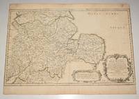
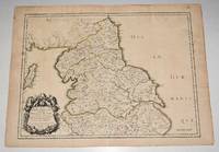
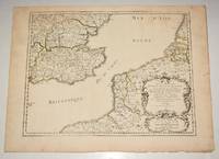
Nicholas Sanson
"Anciens Royaumes de Mercie et East Angles ou sont les Comtes ou Shiries de Chester Darby Nottingham Lincolne Rutland Leicester Stafford Shrop-Sh Hereford Worcester Warwick Northampton Huntington Bedford Buskingham Oxford et Glocester en Mercie Cambridge Norfolk et Suffolk en East Angles". Decorative map of central England from Norwich in the East to Cardiff in the West.
PARIS Chez l’Auteur 1654. Title cartouche to lower right corner. Blank on verso. In good condition. Some light tanning on edges with a few faint foxing marks. With original outline hand colouring. Engraved Size 17.5 x 23 inches Nicolas Sanson 1600-1667 sometimes called Nicolas Sanson d'Abbeville or Sanson d'Abbeville was the most important French cartographer of the 17th century. Tooley called Sanson "the founder of the French school of cartography." He began making maps in the late 1620s and in the 1630s he was working with Melchior Tavernier. Later Sanson worked in concert with the print publisher Pierre Mariette with whom he published his great atlas: Cartes générales de toutes les parties du monde 1658. After Sanson's death in 1667 his son Guillaume carried on the business in partnership with Alexis Hubert Jaillot. Guillaume established himself as a very important French mapmaker in his own right. PARIS Chez l’Auteur 1654. unknown
Bookseller reference : 90475
|
|
|
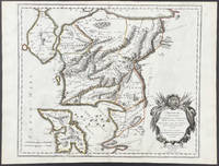
Nicholas Sanson
'Ancien Royaume de Northumberland aujourdhuy Provinces de Nort. Engraved map of northern England focusing on Northumberland.
PARIS Chez l’Auteur 1654. Title cartouche to lower left corner. Blank on verso. In good condition. Some light tanning on edges with a few faint foxing marks. A few hole top of centre fold on map. Small neatly repair tear lower margin and small hole top margin. With original outline hand colouring. Engraved Size 17.5 x 23 inches Nicolas Sanson 1600-1667 sometimes called Nicolas Sanson d'Abbeville or Sanson d'Abbeville was the most important French cartographer of the 17th century. Tooley called Sanson "the founder of the French school of cartography." He began making maps in the late 1620s and in the 1630s he was working with Melchior Tavernier. Later Sanson worked in concert with the print publisher Pierre Mariette with whom he published his great atlas: Cartes générales de toutes les parties du monde 1658. After Sanson's death in 1667 his son Guillaume carried on the business in partnership with Alexis Hubert Jaillot. Guillaume established himself as a very important French mapmaker in his own right. PARIS Chez l’Auteur 1654. unknown
Bookseller reference : 90476
|
|
|
Nicholas Sanson
Anatolie 1692
1692. No Binding. Very Good/No Jacket. Attractive hand coloured map of Anatolia Turkey by Nicholas Sanson from 1692. From Introductio ad Geographiam novam et veterem. Regionis Tabulae item Chartae LXV Sansonis. Ex Officina Francisci Halma Utrecht 1692. Page size 23.5 x 18 cm approx single fold Tape to the corners tape reside to the right hand edge otherwise only light wear and marks colours bright. Good margins. Very Good overall. Free standard airmail worldwide. This does not include tracking which is available at additional cost. unknown
Bookseller reference : 12650
|
|
|
Nicholas Sanson (1600-1667).
Basse Lombardie où sont les Estats de Venise en Italie Mantove Parme Modène Trente 17th Century Map.
Paris: 17th Century European Publisher 1648. 22 x 16 inches. Very Good. 17th Century hand colored map of Lower Lombardy. Some toning and two one-inch tears at bottom edge. Text in French. Scarce.Nicholas Sanson 1600-1667 is considered the father of French cartography in its golden age from the mid-seventeenth century to the mid-eighteenth. Over the course of his career he produced over 300 maps. His success can be chalked up to his geographic and research skills but also to his partnership with Pierre Mariette. Previously Sanson had worked primarily with the publisher Melchior Tavernier. Mariette purchased Tavernier’s business in 1644. Sanson worked with Mariette until 1657 when the latter died. Mariette’s son also Pierre helped to publish the Cartes générales de toutes les parties du monde. [Paris]: 17th Century European Publisher, [1648]. unknown
Bookseller reference : 18-1027

|
|
|
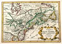
Nicholas Sanson (1600-1667)
Canada of Niew Vrankryk Getrokken Uit Verscheide Fransche Engelsche en Hollandsche Beschryvingen Enz.
Amsterdam c.1705. Very Good. Notes: A reduced version of the most influential 17th century maps of the French and English colonies in North America. The map not only shows details of the Great Lakes but also it is a great source for Indian tribal names and locations. Two names Aouentsiouaeron and Attiouandarons appear here for the first time. Lake Superior and Michigan Lac du Puans are left open-end to the west. It is engraved by Anthony d'Winter. Size : 207x300 mm 8.15x11.81 Inches Coloring: Hand Colored Reference: Burden #575; Kershaw #138. Category: Maps Canada East; Maps North America Great Lakes; unknown
Bookseller reference : M11241
|
|
|
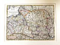
Nicholas Sanson (1600-1667)
Estats de la couronne de Pologne
Paris c.1683. Very Good. Notes: French map showing Poland and the surrounding region.<br>Nicolas Sanson 1600–1667 was a renowned French cartographer termed by some as the "father of French cartography." His works are known for their incorporation of the most up to date information of the time and their clean modern style. Size : 188x256 mm 7.40x10.08 Inches Coloring: Hand Colored Category: Maps Europe Poland Lithuania; unknown
Bookseller reference : M11172
|
|
|
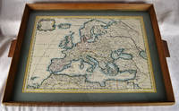
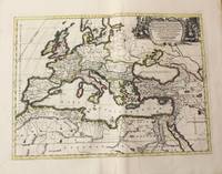
Nicholas Sanson; Pierre Mariette
Europa Vetus ex Conatih. Geographicis N. Sanson Abbavillaei. Christianiss. Galhiar. Regis Geographi Original Colored Map Framed Under Glass
Petrum Mariette: Lutetiae Parisiorum 1650. First Edition. Maps. Very Good. Ancient Europe : The Roman Empire Fine hand-colored double-page engraved map of Roman provinces of Europe. Mounted in wood frame with wooden side handles. Dimensions of mounted image: 40 x 56 cm. 53 x 69.5 cm in frame. Latin province names cities seas. This is an oversized or heavy book which requires additional postage for international delivery outside the US. Petrum Mariette: Lutetiae Parisiorum unknown
Bookseller reference : 2312280001
|
|
|
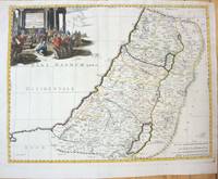
Nicholas Sanson (1600-1667)
Geographiae Sacrae ex V.& N. Test Desumptae Tabula Secunda in qua Terra Promissa.
Paris 1660. Very Good;. Notes: French map of the Holy Land with a decorative cartouche.<br><br>Nicolas Sanson 1600–1667 was a renowned French cartographer termed by some as the "father of French cartography." His works are known for their incorporation of the most up to date information of the time and their clean modern style. Size : 385x485 mm 15.16x19.09 Inches Coloring: Hand Colored Category: Maps Asia Middle East Holy Land & Palestine; unknown
Bookseller reference : M7049
|
|
|
Nicholas Sanson
Original Engraved Map Anciens Royaumes De Kent D'Essex et De Sussex ou sont Aujourdhuy les Comtés Kent D'Essex Middlessex Et Hartford De Sussex Et Surrey. Avecq le Pas De Calais et Partie des Costes du Pays Bas de Picardie et Normandie. Sanson's Double page map of the south east England shown with the adjacent coastline of France and Belgium.
PARIS Chez l’Auteur 1654. Title cartouche to lower right corner. Blank on verso. In good condition. Some light tanning on edges with a few faint foxing marks. A few small nicks lower margin edge. With original outline hand colouring. Engraved Size 17.5 x 23 inches Nicolas Sanson 1600-1667 sometimes called Nicolas Sanson d'Abbeville or Sanson d'Abbeville was the most important French cartographer of the 17th century. Tooley called Sanson "the founder of the French school of cartography." He began making maps in the late 1620s and in the 1630s he was working with Melchior Tavernier. Later Sanson worked in concert with the print publisher Pierre Mariette with whom he published his great atlas: Cartes générales de toutes les parties du monde 1658. After Sanson's death in 1667 his son Guillaume carried on the business in partnership with Alexis Hubert Jaillot. Guillaume established himself as a very important French mapmaker in his own right. PARIS Chez l’Auteur 1654. unknown
Bookseller reference : 90474
|
|
|
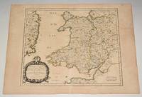
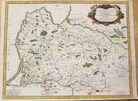
Nicholas Sanson
Principauté de Galles: ou sont les Comtés ou Shiries de Anglesey I. Carnarvan Denbigh Flint Merioneth et Montgomery en Nort-Walles. MAP of WALES
PARIS Chez l’Auteur 1658. Title cartouche to lower left corner. Blank on verso. In good condition. Some light tanning on edges with a few faint foxing marks. With original outline hand colouring. Engraved Size 17.5 x 23 inches Nicolas Sanson 1600-1667 sometimes called Nicolas Sanson d'Abbeville or Sanson d'Abbeville was the most important French cartographer of the 17th century. Tooley called Sanson "the founder of the French school of cartography." He began making maps in the late 1620s and in the 1630s he was working with Melchior Tavernier. Later Sanson worked in concert with the print publisher Pierre Mariette with whom he published his great atlas: Cartes générales de toutes les parties du monde 1658. After Sanson's death in 1667 his son Guillaume carried on the business in partnership with Alexis Hubert Jaillot. Guillaume established himself as a very important French mapmaker in his own right. PARIS Chez l’Auteur 1658 unknown
Bookseller reference : 90477
|
|
|
Nichols, Beverley; Cort, Van; Burger, Knox; McQuade, Walter; Williams, Nick Boddie; Sims, Marian; Corrigan, Barbara; Ross, Robert; Galton, Lawrence; Wathen, Marie; Lagemann, John; Downs, Kenneth; Becker, Edwin; Denham, Avery; et al
Collier's Magazine, November 16, 1946 - Quarterback Glenn Dobbs of the Dodgers
114 pages. Fiction: The Vultures; That Time, That Sorrow; The Wooing of Cruller McCabe; Off the Reservation; Storm Before Daybreak; The Star Lake Murder; Divide & Conquer. Articles: Motherhood without Misery - painless childbirth technique from England; Old Man River's Children - the poor who live along the Mississippi near Memphis; The Handwriting on the Ice - blitzkrieg by air from the arctic; Racket on Wheels - black market used cars; Ringtail on the Run - coon-hunting by moonlight; Preacher in Song - Joshua (Josh) White; Quarterback Glenn Dobbs of the Dodgers; Blondie's Gold Mine - the saga of the cartoon Bumstead family. Ads include: Studebaker (color photo ad inside front cover); Clicquot Club; Philco radio-phonographs - featuring photo of Bing Crosby; Lucky Strike cigarettes; Nice color two-page Firestone ad features dozens of gifts; Camel cigarettes (More doctors smoke Camels...); Hudson cars; Gillette ad features caricature of footballer Dewitt "Tex" Coulter; Hudson cars (beautiful color ad); Movie ad for "The Best Years of Our Lives"; Good Year (centerfold); Samson card tables; Garod Radios; Champ Hats; Mercury cars; Budweiser beer; Fortune shoes; Waterman's pens; Waltham watches; Mallory Hats; Parker pens; Timely clothes; Old Spice; Manhattan sport shirts; Three Feathers Whiskey (inside back cover); Chesterfield cigarettes (back cover). Unmarked. Moderate wear. Cover holding by one staple. A nice vintage copy. Book

|
|
|
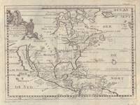
Nicolas d'Abbeville Sanson
Le Nouveau Mexique et la Floride: Tirees de diverses Cartes et Relations Map of America with California Florida Mexico and Virginia Named
<p>Engraving outlined in original color in the third state with <em>Chez l'Autheur </em>to the cartouche. Sanson's first large format regional map of North America depicting California as an island. The map measures approximately 21.5 x 12.5 in 54.5 x 32 cm with the paper size being 23.5 x 17.75 in 60 x 45 cm. Scarce.</p>
Bookseller reference : 9429
|
|
|
Nicolas d'Abbeville Sanson; Guillame Sanson
Troianum Regnum Novem Dinasteias Complectens; Priami dum Regna Manebant; Adjecta sunt ea quae etiam Innotuere Posterioribus Temporibus Nomina Map of Turkey
<p>Scarce map engraving outlined in original color from Sanson's <em>Cartes Generales de Toutes les Parties du Monde. </em>The image measures approximately 19.75 x 16.5 in 50 x 42 cm; page measures 23.25 x 17.5 in 59 x 44.5 cm.</p> Pierre Mariette
Bookseller reference : 9482
|
|
|
Nicolas Sanson
Description des Isles du Iapon 17th-century old map Japan map
Not Available N.A. Soft Cover. Fine. Number of books: 1 Not Available paperback
Bookseller reference : 2091202133208116
|
|
|
Nicolas Sanson
Florida zoo als het van de Spaanschen en Franschen wordt bezeten
Attractive original hand-color. Pin-head size stain just south of Mississippi delta please see image. An otherwise very nice clean copy. Paper size: 8 1/4 x 12 1/4 in 210 x 310 mm. Image size: 7 x 9.8 in 178 x 250 mm. ; All shipments through USPS insured Priority Mail.
Bookseller reference : 3903

|
|
|
Nicolas Sanson; Melchior Tavernier; Pierre Mariette
Galliae antiquae descriptio geographica Original Framed 17th Century Map
Paris : Tavernier et a present Pierre Mariette 1641. First Edition. Maps. Good. 53 x 40 cm. Original engraved double page map of France. In gilt and black frame under glass. Some browning. Scale: 1:3000000. Paris : Tavernier, et a present Pierre Mariette unknown
Bookseller reference : 1809140021

|
|
|
Nicolas Sanson
Geographia Patriarchalis Tabula Geographica in Epitomen Contracta in qua Patriarchatus Antiqui.
Amsterdam: Jean Covens & Corneille Mortier c.1710. Very Good. Size : 413x562 mm 16.26x22.13 Inches Coloring: Original Hand Coloring Category: Maps Europe Continent; Maps Africa North; Maps Mediterranean Sea; Jean Covens & Corneille Mortier unknown
Bookseller reference : M10325
|
|
|
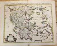
Nicolas Sanson
Graeciae Antiquae Tabula Geographica; cujus Quinque Majores Partes Sunt Macedonia Thessalia Epirus Achaia et Peloponnesus.
Amsterdam: Jean Covens & Corneille Mortier c.1710. Very Good. Size : 470x566 mm 18.50x22.28 Inches Coloring: Original Hand Coloring Category: Maps Europe Greece Macedonia; Jean Covens & Corneille Mortier unknown
Bookseller reference : M10235
|
|
|
Nicolas Sanson
In Pharum Galliae Antiquae Philippi Labbe Biturici Et Societatis Iesu Sacerdotis Disquisitiones Geographicae 1647
New. unknown
Bookseller reference : A9781166040635 ISBN : 1166040631 9781166040635
|
|
|
Nicolas Sanson
In Pharum Galliae Antiquae Philippi Labbe Biturici Et Societatis Iesu Sacerdotis Disquisitiones Geographicae 1647
New. unknown
Bookseller reference : B9781166040635 ISBN : 1166040631 9781166040635
|
|
|
Nicolas Sanson
Introduction à la Geographie: Où Sont la Geographie Astronomique Qui Explique la Correspondance du Globe Terrestre Avec la Sphere Classic Reprint French Edition
paperback. Good. Access codes and supplements are not guaranteed with used items. May be an ex-library book. paperback
Bookseller reference : 1333160763.G ISBN : 1333160763 9781333160760
|
|
|
Nicolas Sanson
Introduction à la Geographie: Où Sont la Geographie Astronomique Qui Explique la Correspondance du Globe Terrestre Avec la Sphere Classic Reprint
hardcover. Good. Access codes and supplements are not guaranteed with used items. May be an ex-library book. hardcover
Bookseller reference : 0656632127.G ISBN : 0656632127 9780656632121
|
|
|
Nicolas Sanson
Introduction A la Geographie des Srs Sanson Géographes du Roi Classic Reprint
hardcover. Good. Access codes and supplements are not guaranteed with used items. May be an ex-library book. hardcover
Bookseller reference : 0428884288.G ISBN : 0428884288 9780428884284
|
|
|
Nicolas Sanson
Introduction A la Geographie des Srs Sanson Géographes du Roi Classic Reprint French Edition
paperback. Good. Access codes and supplements are not guaranteed with used items. May be an ex-library book. paperback
Bookseller reference : 0259030171.G ISBN : 0259030171 9780259030171
|
|
|
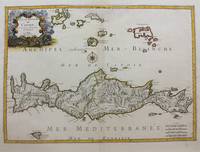
Nicolas Sanson
Isle et Royaume de Candie
Paris: Nicolas Sanson c.1658. Very Good upper fold area expertly repaired. Notes: A fine map of Crete from the mid 17th century. <br>The map also shows nearby islands such as Santorini Stampalia and Milo. The map has a decorative cartouche and details cities borders and geographical features. Size : 394x553 mm 15.51x21.77 Inches Coloring: Hand Colored Category: Maps Europe Greece Macedonia; Nicolas Sanson unknown
Bookseller reference : M9417
|
|
|
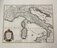
Nicolas Sanson
Italia Antiqua cum Insulis Sicilia Sardinia & Corsica.
Amsterdam: Jean Covens & Corneille Mortier c.1702. Very Good. Size : 420x528 mm 16.54x20.79 Inches Coloring: Hand Colored Category: Maps Europe Italy; Maps Mediterranean Islands; Jean Covens & Corneille Mortier unknown
Bookseller reference : M10242
|
|
|
Nicolas Sanson I
L Afrique En Plusieurs Cartes Nouvelles et Exactes & en Divers Traicte s de Geographie et d Histoire.
Paris: Nicolas Sanson c. 1656. Lower right corner of the first eight leaves strengthened otherwise a very good copy maps and text are clean and crisp. In protective cloth slipcase. Edition: First edition. Binding: Full contemporary calf expertly rebacked with spine in six compartments of raised bands and finely-gilt motifs morocco label on two edges speckled red. Notes: This atlas was dedicated to the Superintendent of Finances at the time Nicolas Fouquet. <br>Regarding a map of South and Central Africa published the year before which bears resemblance to this map of South Africa--‘Pays et Costes des Caffres’--in particular Norwich writes: “This map although a fine example of cartography is based on very little information; for example the desert-like coast of South West Africa is presented as a land rich in rivers. The fictitious states are given fictitious boundaries and the interior is marked with large cities such as Vigiti Magna and Monomotapa. This information led to subsequent exploration in search of these fabulous cities. Although the map is dated three years after the foundation of a settlement at the Cape by Jan van Riebeeck no mention is made of any European settlement anywhere in the south.†Size: 4to Illustration: Recent stencilled title. Complete with 18 maps of Africa and its territories in original outline colour. References: Tooley IV:103; Tooley Africa 100 Peyrounin edition; Norwich 37 & 158. Pages: P. 1-96. Category: Book Africa General; Book Atlas & Cartography Nicolas Sanson hardcover
Bookseller reference : B2984
|
|
|
Nicolas Sanson
l'Amerique Septentrionale Map
Sanson being d'Abbeville Geograph du Roy. Map covers North America with a small amount of South America included. Has California as an island. 9 3/4 x 7 1/2 inches. Chez Paul Marret
Bookseller reference : 5097
|
|
|
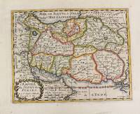
Nicolas Sanson
L'Empire du Sophy des Perses.
Paris 1652. Very Good. Notes: This is an important 17th-century map of Iran published in Paris by Nicolas Sanson the greatest 17th-century French cartographer. The map depicts Iran at the time of Shah Abbas II of the Safavid dynasty. It is interesting to note that present-day Afghanistan and Pakistan and even part of India sit within Iran's borders all of which were lost in due course by the kings of the Qajar dynasty. Also as Sufism was the religion of Iran at the time of the Safavid dynasty the title of the map refers to the "Empire of the Sufi of the Persians". Size : 192x247 mm 7.56x9.72 Inches Coloring: Hand Colored Reference: Ala'i E. 107. Category: Maps Asia Middle East Iran Iraq; unknown
Bookseller reference : M4655
|
|
|
Nicolas Sanson
L'Europe en Plusieurs Cartes Et en Divers Traittés de Geographie Et d'Histoire: Là ou-Sont Décrits Succinctement Et Avec une Belle Methode Et . Richesses &C.; Et ce qu' French Edition
hardcover. Good. Access codes and supplements are not guaranteed with used items. May be an ex-library book. hardcover
Bookseller reference : 0656849703.G ISBN : 0656849703 9780656849703
|
|
|
Nicolas Sanson
L'Europe en Plusieurs Cartes Et en Divers Traittés de Geographie Et d'Histoire: Là ou-Sont Décrits Succinctement Et Avec une Belle Methode Et . Richesses &C.; Et ce qu'Il French Edition
paperback. Good. Access codes and supplements are not guaranteed with used items. May be an ex-library book. paperback
Bookseller reference : 0282461914.G ISBN : 0282461914 9780282461911
|
|
|
Nicolas Sanson (1600-1667)
La Curlande Duche et Semigalle Autresois de la Livonie
Paris 1659. Very Good. Notes: Map of Baltic region of Estonia Latvia including Riga to Vilnius Wilna and parts of Lithuania. <br><br>Nicolas Sanson 1600–1667 was a renowned French cartographer termed by some as the "father of French cartography." His works are known for their incorporation of the most up to date information of the time and their clean modern style. Size : 410x535 mm 16.125x21 Inches Coloring: Original Outline Coloring Reference: Category: Maps Europe Estonia Latvia unknown
Bookseller reference : M4916
|
|
|
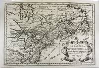
Nicolas Sanson (1600-1667)
Le Canada ou Nouvelle France & c. Tiree de diverses Relations des Francois Anglois Hollandois & c.
Paris 1700. Excellent. Notes: Second state. Published in Description De Tout L'Universe-Halma.<br>An excellent example of Nicolas Sanson's map of Canada and the Great Lakes Lake Superior and Lake Michigan Lac du Puans are shown open-ended.<br>Engraved in the bottom-right corner outside the neat-line is "A.d.Winter Schulp". Additions include a latitude and longitude grid; mountains and trees filling in the blank areas east of James Bay and in northern Labrador; and the three latitude and longitude values that were previously missing in three of the corners on the border. Size : 207x308 mm 8.15x12.13 Inches Coloring: Black & White Reference: Burden #575; Kershaw #137 Plate 85 Category: Maps Canada East; Maps North America Great Lakes; unknown
Bookseller reference : M11077
|
|
|
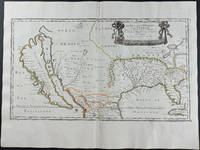
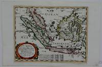
Nicolas Sanson (1600-1667)
Les Isles de la Sonde entre les quelles sont Sumatra Java Borneo
Paris 1660. Excellent. Notes: French map of South East Asia. Size : 195x250 mm 7.625x9.875 Inches Coloring: Hand Colored Category: ; Maps Asia South East Malaysia & Singapore; Maps Asia South East Indonesia & Papua New Guinea unknown
Bookseller reference : M5006
|
|
|
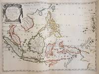
Nicolas Sanson d'Abbeville / I. Somer
Les Isles Philippines Molucques et de la Sonde…
<p>40.1 x 56 cm original outline hand-colour copper engraving. EXTREMELY RARE map probably from ''Cartes generales de toutes les parties du monde' . Condition: with folds as issued with water stains and professionally repaired tear on lower left margin not affecting plate. Reference: Quirino p. 83; BMC Printed Maps XII col.867; Cat.Nat.mar.Mus.271 map 15; Nordenskiöld 275 vol.1 map 17; pastoureau Sanson V map 12.</p> Pierre Mariette, Paris.
Bookseller reference : 61177
|
|
|
Nicolas Sanson
Map Les Isles dv Iapon Reproduction <Japanese Version>
Not Available N.A. Soft Cover. Fine. Size: Plate: 18.5cmx24cm / Paper: 39cmx48cm Number of copies: 1 sheet Not Available paperback
Bookseller reference : 2092902138101576
|
|
|
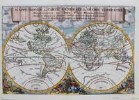
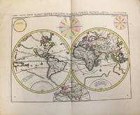
Nicolas Sanson
Mappe-Monde ou Carte Generale du Globe Terrestre
Trajecti ad Rhenum : Francisci Halma c. 1692. Very Good. Notes: A finely engraved map of the world by Nicolas Sanson "the father of French cartography" during the late 17th century. Engraved by A. de Winter. There are a lot of fascinating cartographic errors that were made such as California being shown as an island and the western half of North America not being depicted as it had yet to be discovered. But the treatment of far and southeast Asia is much improved when we compare it to Sanson's map of 1652. Korea reverts to an attenuated peninsula instead of the short squat round island in the earlier Sanson version. Likewise the partial outline of Australia changes it shape to a much more realistic outline of Australia. Size : 200x305 mm 7.87x12.01 Inches Coloring: Hand Colored Category: Maps World; Francisci Halma unknown
Bookseller reference : M9110
|
|
|
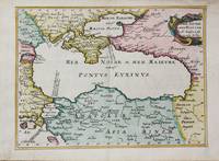
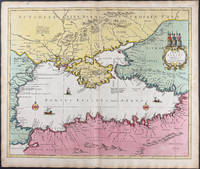
Nicolas Sanson
Mer Noire ou Mer Maieure
Paris c.1656. Very Good. Size : 182x246 mm 7.17x9.69 Inches Coloring: Hand Colored Category: Maps Russia; Maps Asia Near East Turkey; Maps Europe Ukraine; unknown
Bookseller reference : M10647
|
|
|
Nicolas Sanson
Orbis Vetus et Orbis Veteris Utraque Continens Terrarum Tractus Arcticus et Antarcticus ex Platone.
Amsterdam: Covens & Mortier c.1696. Very Good. Size : 393x540 mm 15.47x21.26 Inches Coloring: Original Hand Coloring Category: Maps World; Covens & Mortier unknown
Bookseller reference : M10191
|
|
|
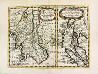
Nicolas Sanson (1600-1667)
Partie de L'inde au dela du gange; Presqv-Isle de L'inde au dela du gange.
Paris. 1652. Very Good. Notes: Fine 17th century map of Thailand Burma and Malaysia.<br><br> Size : 191x249 mm 7.50x9.80 Inches Coloring: Original Hand Coloring Category: Maps Asia South East Thailand Laos Vietnam Cambodia & Burma / Myanmar; Maps Asia South East Malaysia & Singapore; unknown
Bookseller reference : M8177
|
|
|
Nicolas Sanson [Published by Pierre Mortier]
Ponti euxini cum periplus auctore Map of the Black Sea
<p>Scarce original hand-colored engraving by Sanson published in Pierre Mortier's <em>Atlas Nouveau</em> or <em>Atlas Novum ad usum serenissimi</em>.</p><p>Image size is approximately 23 x 18.75 in 58.5 x 47.5 cm; page size is 24.75 x 21 in 63 x 53.5 cm.</p><p>Some minor staining and toning to edges not affecting the image.</p>
Bookseller reference : 9749
|
|
|
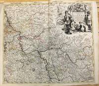
Nicolas Sanson
Teatre De La Guerre sur le Rhein Moessele Mayn & le Necker.
Amsterdam: Pierre Mortier c.1708. Very Good. Notes: "Theatre de la Guerre" Theater of War maps covering the battles raging in Europe and the Americas during the Spanish War of Succession 1701-1713 and the Northern War 1700-1721. The atlas maps are large folio size with most maps made of two sheets and many maps combining 4 or 6 sheets those also issued as wall maps separately. The atlas is most impressive for its large size and number of maps as well as being up to date for its time. <br><br> Size : 517x585 mm 20.35x23.03 Inches Coloring: Original Outline Coloring Category: Maps Europe Germany; Pierre Mortier unknown
Bookseller reference : M10193
|
|
|
Nicolas Sanson
Voyage ou Relation de l'Etat Present du Royaume de Perse: Avec une Dissertation Curieuse sur les Moeurs Religion Et Gouvernement de Cet Etat Classic Reprint
hardcover. Good. Access codes and supplements are not guaranteed with used items. May be an ex-library book. hardcover
Bookseller reference : 0666787816.G ISBN : 0666787816 9780666787811
|
|
|
Nicolas Sanson
Voyage ou Relation de l''Etat Present du Royaume de Perse: Avec une Dissertation Curieuse sur les Moeurs Religion Et Gouvernement de Cet Etat Classic Reprint
paperback. Good. Access codes and supplements are not guaranteed with used items. May be an ex-library book. paperback
Bookseller reference : 0282862579.G ISBN : 0282862579 9780282862572
|
|
 Receive by email
 Download as PDF document
 RSS feed


