|
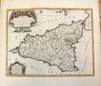
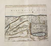
Hubert Jaillot; Sanson
La Sicile divisee en ses trois Provinces ou Valees scavoir Valle Di Demona Valle Di Noto et Valle Di Mazara.
Amsterdam: Covens & Mortier c.1696. Very Good. Size : 420x540 mm 16.54x21.26 Inches Coloring: Hand Colored Category: Maps Mediterranean Islands; Covens & Mortier unknown
Bookseller reference : M10189
|
|
|
Sanson, Nicolas d'Abbeville
Sarmatia Utraque Europaea et Asiatica
Paris 1654. Excellent. Size : 415x483 mm 16.375x19 Inches Coloring: Original Outline Coloring Category: Maps Russia unknown
Bookseller reference : M2853
|
|
|
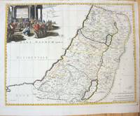
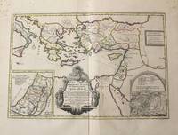
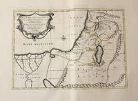
Nicholas Sanson (1600-1667)
Geographiae Sacrae ex V.& N. Test Desumptae Tabula Secunda in qua Terra Promissa.
Paris 1660. Very Good;. Notes: French map of the Holy Land with a decorative cartouche.<br><br>Nicolas Sanson 1600–1667 was a renowned French cartographer termed by some as the "father of French cartography." His works are known for their incorporation of the most up to date information of the time and their clean modern style. Size : 385x485 mm 15.16x19.09 Inches Coloring: Hand Colored Category: Maps Asia Middle East Holy Land & Palestine; unknown
Bookseller reference : M7049
|
|
|
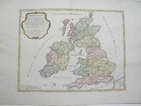
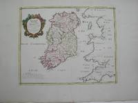
N. Sanson; Robert Vaugondy
Britannicae Insulae
Paris 1754. Excellent. Size : 410x540 mm 16.125x21.25 Inches Coloring: Hand Colored Category: ; Maps Europe Ireland;; Maps Europe United Kingdom unknown
Bookseller reference : M3766
|
|
|
N. Sanson
Iesu Christi Salvatoris Nostri Et Apostolorum Petri et Pauli.
Amsterdam: Jean Covens & Corneille Mortier c.1710. Very Good. Notes: With 2 inset maps showing the Holy Land and Hierusalem. Size : 375x550 mm 14.76x21.65 Inches Coloring: Original Hand Coloring Category: Maps Asia Near East Turkey; Maps Asia Middle East Holy Land & Palestine; Maps Mediterranean Sea; Jean Covens & Corneille Mortier unknown
Bookseller reference : M10319
|
|
|
Fortin; Sanson
Irlande Royaume divise en ses quatre Provinces et ces Provinces en leurs comtes.
Paris 1778. Excellent. Size : 405x501 mm 15.875x19.75 Inches Coloring: Hand Colored Category: ; Maps Europe Ireland unknown
Bookseller reference : M3768
|
|
|
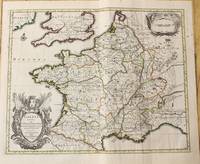
S. Sanson; Robert Vougandy; Delamarche
Galliarum Descriptio ex Sansonum Tabulis editis et manuscriptis excerpta etc.
Paris: Sr. Delamarche c.1760. Very Good. Notes: Engraved by Delahaye. Large scale attractive map of France. Size : 493x668 mm 19.41x26.30 Inches Coloring: Original Hand Coloring Category: Maps Europe France; Sr. Delamarche unknown
Bookseller reference : M7988
|
|
|
Sanson
Partie de Lithuanie ou sont en partie les Palatinats de Minsk et Mseislaw we les Seign.Ries ou Terres de Rohaczow Rzeczica Zernobee et partie des Dvches de Novogrodeck sewierski et de Zernihow.
Paris: Mariette Pierre 1666. Very Good. Size : 410x555 mm 16.125x21.875 Inches Coloring: Hand Colored Reference: Mojski Piotr Maria "Cartographia Rappersviliana Polonorum" page 388 number 32; Category: ; Maps Europe Poland Lithuania Mariette, Pierre unknown
Bookseller reference : M1204
|
|
|
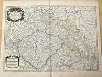
Sanson; Jaillot
Estats De La Couronne De Boheme qui comprennent Le Royaume De Boheme Le Duche De Silesie.
Paris c.1785. Very Good. Size : 470x658 mm 18.50x25.91 Inches Coloring: Original Outline Coloring Category: Maps Europe Czech Republic Slovakia; Maps Europe Germany; unknown
Bookseller reference : M10271
|
|
|
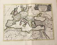
S Sanson; Pierre Mortier
Estats De L'Empire Des Turqs En Europe Subdiuises Suiuant lcstendue des Beglerbeglicz ou Gouvernements dans les quels sont Marquees les Residences des Sangiacz qui endependent Tires de plusieurs Memoires et des Relations les plus Recentes.
Amsterdam: Pierre Mortier 1720. Very Good. Notes: A fine large scale map of Mediterranean Sea Italy Greece Eastern Europe Turkey. The map depicts the Ottoman Empire in the mid to late seventeenth century. Size : 530x864 mm 20.87x34.02 Inches Coloring: Original Hand Coloring Category: Maps Europe Balkans; Maps Mediterranean Sea; Maps Europe Italy; Maps Europe Greece Macedonia; Maps Asia Near East Turkey; Pierre Mortier unknown
Bookseller reference : M8856
|
|
|
S. Sanson; S. Iallot
La Basse Partie Du Cercle Du Haut Rhein divise en tous ses Estats et Souverainetes.
Paris c. 1700. Very Good. Notes: Engraved by Cordier.<br>A map of Central Germany. Frankfurt appears at the south-center of the map. Size : 457x648 mm 17.99x25.51 Inches Coloring: Original Hand Coloring Category: Maps Europe Germany; unknown
Bookseller reference : M7994
|
|
|
Nicolas Sanson
Italia Antiqua cum Insulis Sicilia Sardinia & Corsica.
Amsterdam: Jean Covens & Corneille Mortier c.1702. Very Good. Size : 420x528 mm 16.54x20.79 Inches Coloring: Hand Colored Category: Maps Europe Italy; Maps Mediterranean Islands; Jean Covens & Corneille Mortier unknown
Bookseller reference : M10242
|
|
|
Sanson, Nicholas
Orbis Vetus et Orbis Veteris Utraque Continens Terrarum Tractus Arcticus et Antarcticus
Paris 1657 . Very Good. Notes: A handsome 17th century map of the known world typifying Sanson's scientific style of cartography. Embodying the most up to date information of the period Sanson's map depicts California as an island with Antarctica and Australia still largely unknown. A land bridge connects Asia to North America and touches Japan. A very accurate map for the period. Nicolas Sanson 1600–1667 was a French cartographer termed by some the creator of French geography in which he's been called the "father of French cartography." <br><br><br> Size : 380x537 mm 14.96x21.14 Inches Coloring: Original Hand Coloring Reference: Shirley R.W. World 400; Pastoureau M. Sanson V A 98. Category: Maps World; unknown
Bookseller reference : M8883
|
|
|
Sanson
Africa Vetus
Paris: Pierre Mariette c. 1650. Very Good;. Notes: Title cartouche bordered by two outward-facing birds of prey.<br><br>Norwich writes: "This is an early Sanson map. An odd feature is the name Barditus Mons given to a long chain of mountains running continuously from somewhere in Angolato Algoa Bay. No place names appear even on the coast of the southern part of the continent which is labelled 'Agi Symba' a name usually referring to the northern African region and inhabitants are 'Anthropophagi Aethiopes' or cannibals." Size : 396x553 mm 15.59x21.77 Inches Coloring: Hand Colored Reference: Norwich's Map 35. Category: Maps Africa Continent; Pierre Mariette unknown
Bookseller reference : M6678
|
|
|
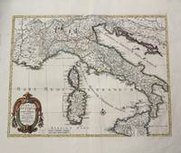
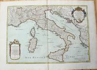
Sanson
L'Italie et les Isles circomuoisines Sicile Sardagne Corse. . .
Paris 1665. Very Good central fold reinfrced. Notes: There is a water mark on the right hand portion of the map. Size : 435x540 mm 17.125x21.25 Inches Coloring: Original Outline Coloring Category: ; Maps Europe Italy unknown
Bookseller reference : M5118
|
|
|
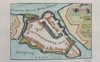
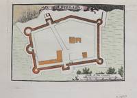
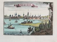
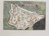
Jaillot; Sanson
Passava
Paris c.1690. Very Good. Notes: Map of Passava Greece during the late 17th century. Size : 104x153 mm 4.09x6.02 Inches Coloring: Hand Colored Category: Maps Europe Greece Macedonia; unknown
Bookseller reference : M9481
|
|
|
N. Sanson
Patriarchatus Romanus
Amsterdam: Jean Covens & Corneille Mortier c.1710. Very Good. Size : 375x525 mm 14.76x20.67 Inches Coloring: Original Hand Coloring Category: Maps Africa North; Maps Europe Continent; Maps Mediterranean Sea; Jean Covens & Corneille Mortier unknown
Bookseller reference : M10326
|
|
|
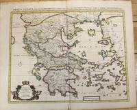
Nicolas Sanson
Graeciae Antiquae Tabula Geographica; cujus Quinque Majores Partes Sunt Macedonia Thessalia Epirus Achaia et Peloponnesus.
Amsterdam: Jean Covens & Corneille Mortier c.1710. Very Good. Size : 470x566 mm 18.50x22.28 Inches Coloring: Original Hand Coloring Category: Maps Europe Greece Macedonia; Jean Covens & Corneille Mortier unknown
Bookseller reference : M10235
|
|
|
S. Sanson; S. Jallot
Le Cercle De Westphalie divise en tous ses Estats et Souverainetes
Paris: S. Jallot c. 1700. Very Good. Notes: Map of Northern Germany Size : 650x460 mm 25.59x18.11 Inches Coloring: Original Hand Coloring Category: Maps Europe Germany; S. Jallot unknown
Bookseller reference : M7991
|
|
|
Nicolas Sanson
Geographia Patriarchalis Tabula Geographica in Epitomen Contracta in qua Patriarchatus Antiqui.
Amsterdam: Jean Covens & Corneille Mortier c.1710. Very Good. Size : 413x562 mm 16.26x22.13 Inches Coloring: Original Hand Coloring Category: Maps Europe Continent; Maps Africa North; Maps Mediterranean Sea; Jean Covens & Corneille Mortier unknown
Bookseller reference : M10325
|
|
|
N. Sanson; S. Jallot
Tabula nova partis meridionalis episcopatus carnutensis ad usum serenissimi Burgundiae Ducis
Paris: H. Jaillot c.1690. Very Good with some minor discoloration. Notes: Map of North-Central France Size : 460x610 mm 18.11x24.02 Inches Coloring: Original Hand Coloring Category: Maps Europe France; H. Jaillot unknown
Bookseller reference : M7990
|
|
|
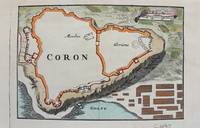
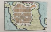
Jaillot; Sanson
Coron
Paris c.1690. Very Good. Notes: Map of Coron Greece during the late 17th century. Size : 103x153 mm 4.06x6.02 Inches Coloring: Hand Colored Category: Maps Europe Greece Macedonia; unknown
Bookseller reference : M9480
|
|
|
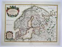
Sanson; Jaillot
La Scandinavie et les Environs ou sont Les Royaumes de Suede De Danemarck et de Norwege; divises en leurs principales Provinces.
Paris 1708. Very Good central fold reinforced mounted on acid free canvas. Size : 474x655 mm 18.625x25.75 Inches Coloring: Hand Colored in Outline Category: ; Maps Europe Scandinavia unknown
Bookseller reference : M4264
|
|
|
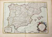
Sanson, Nicolas d'Abbeville - Jaillot, Hubert
L'Espagne divisee en tous ses Royaumes Et Principautes suivant quils sont compris sous Les Couronnes de Castille et D'Aragon.
Paris: H. Jaillot c.1710. Very Good. Size : 465x655 mm 18.31x25.79 Inches Coloring: Original Hand Coloring Category: Maps Europe Portugal; Maps Europe Spain; H. Jaillot unknown
Bookseller reference : M10278
|
|
|
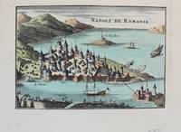
Jaillot; Sanson
Napoli de Romanie
Paris c. 1690. Very Good. Notes: A charming map of Nafplio Greece during the late 17th century. Size : 104x152 mm 4.09x5.98 Inches Coloring: Hand Colored Category: Maps Europe Greece Macedonia; unknown
Bookseller reference : M9576
|
|
|
Sanson
L'Inde de ca et de la le Gange ou est L'Empire du Grand Mogol et Pays Circonvoisins . . .
Paris 1654. Very Good some mild discoloration along the margins. Size : 350x555 mm 13.75x21.875 Inches Coloring: Original Outline Coloring Reference: Gole 16; Nebenzahl 3.9B Category: Maps Asia South East Thailand Laos Vietnam Cambodia & Burma / Myanmar; Maps Asia Central India & Sri Lanka / Ceylon; unknown
Bookseller reference : M5952
|
|
|
N. Sanson
Situs Terrae Canaan Sive Terrae Promissionis Hodie Palaestinae S S.Bibliorum intelligentiam exacte.
Paris: Jean Covens & Corneille Mortier c.1710. Very Good. Size : 397x460 mm 15.63x18.11 Inches Coloring: Hand Colored Category: Maps Asia Middle East Holy Land & Palestine; Jean Covens & Corneille Mortier unknown
Bookseller reference : M10273
|
|
|
G. W. Samson
Elements of Art Criticism; Comprising a Treatise on the Principles of Man's Nature as Addressed by Art Together with a Historic Survey of the Methods of Art Execution in the Departments of Drawing Sculpture Architecture Painting Landscape Gardening…
Philadelphia: J. B. Lippincott Co. c. 1868. The book is in very good condition. . Binding: Contemporary full brown cloth. Tooled border on top and bottom cover. Gilt text and decoration on spine. Notes: This book is a philosophical and intellectual approach to defining mankind’s relationship with the arts and how the arts reflect the desires of man. These ideologies are supported by an extensive survey on the methods of art execution over many different styles. Size: 8vo 187x119mm Category: Book Art Architecture & Design; J. B. Lippincott Co. hardcover
Bookseller reference : B5201
|
|
|
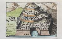
Jaillot; Sanson
Lepanthe
Paris c.1690. Very Good. Notes: A charming map of Lepanto Greece during the late 17th century. Size : 105x153 mm 4.13x6.02 Inches Coloring: Hand Colored Category: Maps Europe Greece Macedonia; unknown
Bookseller reference : M9478
|
|
|
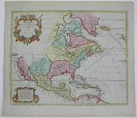
Elwe; Sanson/Jaillot
Amerique Septentrionale Divisee en ses Principales Parties
Amsterdam 1792. Excellent. Notes: North America revised from the Sanson/Jaillot maps. California is shown as a peninsula but named "isle de California" to the northwest is "Mer de Iesso" and beyond that a small stretch of coastline "Terre de Iesso ou Ieco." The Great Lakes are defined if not with great accuracy a number of settlements in Nouveau Mexico are identified and a R. del Norte flows southwest from a large lake near Taosii to the Gulf of California. Size : 480x580 mm 18.875x22.875 Inches Coloring: Original Hand Coloring Category: Maps North America; Maps Central America; Maps West Indies General unknown
Bookseller reference : M4892
|
|
|
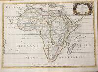
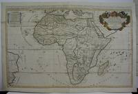
Jaillot, Sanson
L'Afrique divisee suivant l'estendue de ses principales parties. . .
Paris 1719. Excellent. Size : 580x890 mm 22.875x35 Inches Coloring: Original Outline Coloring Category: ; Maps Africa Continent unknown
Bookseller reference : M5162
|
|
|
N. Sanson; MTavernier M. Ta
Patriarchatus Hierosolymitani Geographica descriptio
Amsterdam: Jean Covens & Corneille Mortier c.1710. Very Good. Size : 368x495 mm 14.49x19.49 Inches Coloring: Original Outline Coloring Category: Maps Asia Middle East Holy Land & Palestine; Maps Africa North; Maps Africa North Egypt; Jean Covens & Corneille Mortier unknown
Bookseller reference : M10330
|
|
|
Jaillot; Sanson
S. Maura
Paris c.1690. Very Good. Notes: A charming map of Santa Maura on the island of Lefkada Greece during the late 17th century. <br><br> Size : 104x153 mm 4.09x6.02 Inches Coloring: Hand Colored Category: Maps Europe Greece Macedonia; unknown
Bookseller reference : M9472
|
|
|
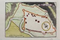
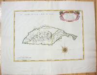
Sanson; Fortin
Provinces Unies et Incorporees a la Couronne de Boheme qui sont les Duche de Silesie Marq sats de Moravie et Lusace.
Paris: Fortin 1778. Very Good. Notes: Map showing Bohemia Silesia Moravia and Lusatia. Size : 420x545 mm 16.5x21.5 Inches Coloring: Hand Colored Category: Maps Europe Poland Lithuania Fortin unknown
Bookseller reference : M4133
|
|
|
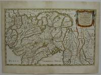
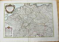
Sanson; H. Jaillot
L'Empire D'Allemagne distingue suivant l'etendue de tous Les Estats Principautes et Souverainetes.
Paris: Chez Brion 1785. Very Good. Notes: Detailed large map of Germany with large decorative cartouches. Size : 465x652 mm 18.31x25.67 Inches Coloring: Original Hand Coloring Category: Maps Europe Germany; Chez Brion unknown
Bookseller reference : M10224
|
|
|
N. Sanson
Gallia Vetus ex C.Iulii Caesaris Comentariis Descripta
Amsterdam: Jean Covens & Corneille Mortier c.1710. Very Good. Size : 378x486 mm 14.88x19.13 Inches Coloring: Original Outline Coloring Category: Maps Europe France; Jean Covens & Corneille Mortier unknown
Bookseller reference : M10329
|
|
|
Jaillot; Sanson
Chielafa
Paris c.1690. Very Good. Notes: Map of Chielafa Greece during the late 17th century. Size : 105x152 mm 4.13x5.98 Inches Coloring: Hand Colored Category: Maps Europe Greece Macedonia; unknown
Bookseller reference : M9479
|
|
|
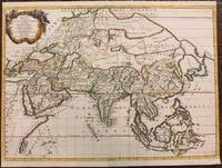
Sanson, Nicolas
Asia Vetus Nicolai Sanson Christianiss Galliar Regis Geographi Recognita Emendata et Multis in locis Mutata Conatibus Geographicis Gulielmi
Paris: Pierre Mariette 1667. Very Good. Notes: An important map of Asia by Nicolas Sanson showing the boundaries of the major historic civilizations of this continent. Examples include Assyria Syria Asia Minor Armenia Arabia Felix Libya Sarmatia Thracia Graecia Persia India China Ethiopia Scythia and Gangem. <br><br>Sanson 1600–1667 was a French cartographer termed by some as the "father of French cartography." His works are known for their incorporation of the most up to date information of the time and their clean modern style. Size : 402x470 mm 15.83x18.50 Inches Coloring: Original Hand Coloring Category: Maps Asia Continent; Pierre Mariette unknown
Bookseller reference : M8921
|
|
|
Sanson, Nicolas d'Abbeville - Jaillot, Hubert
Amerique Meridionale divisee en ses principales Parties ou sont distinguees les vns des autres les Estats suicant quils appartiennent presentement aux Francois Castillans Portugais Hollandois &c
Paris 1691. Very Good. Size : 590x885 mm 23.25x34.875 Inches Coloring: Hand Colored in Outline Category: ; Maps South America Continent unknown
Bookseller reference : M1345
|
|
|
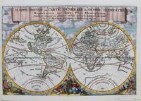
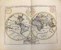
Nicolas Sanson
Mappe-Monde ou Carte Generale du Globe Terrestre
Trajecti ad Rhenum : Francisci Halma c. 1692. Very Good. Notes: A finely engraved map of the world by Nicolas Sanson "the father of French cartography" during the late 17th century. Engraved by A. de Winter. There are a lot of fascinating cartographic errors that were made such as California being shown as an island and the western half of North America not being depicted as it had yet to be discovered. But the treatment of far and southeast Asia is much improved when we compare it to Sanson's map of 1652. Korea reverts to an attenuated peninsula instead of the short squat round island in the earlier Sanson version. Likewise the partial outline of Australia changes it shape to a much more realistic outline of Australia. Size : 200x305 mm 7.87x12.01 Inches Coloring: Hand Colored Category: Maps World; Francisci Halma unknown
Bookseller reference : M9110
|
|
|
Jaillot; Sanson
Negropont
Paris c. 1690. Very Good. Notes: A charming map of Negroponte Chalcis Greece during the late 17th century. Size : 104x154 mm 4.09x6.06 Inches Coloring: Hand Colored Category: Maps Europe Greece Macedonia; unknown
Bookseller reference : M9575
|
|
|
Jaillot; Sanson
F. D'Asso
Paris c.1690. Very Good. Notes: A charming map of Fort D'Asso Greece during the late 17th century. Size : 104x153 mm 4.09x6.02 Inches Coloring: Hand Colored Category: Maps Europe Greece Macedonia; unknown
Bookseller reference : M9473
|
|
|
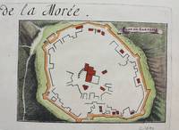
Jaillot; Sanson
Plan de Zarnata
Paris c.1690. Very Good. Notes: A charming map of Zarnata Greece during the late 17th century. Size : 103x152 mm 4.06x5.98 Inches Coloring: Hand Colored Category: Maps Europe Greece Macedonia; unknown
Bookseller reference : M9483
|
|
|
Sanson, Nicolas
Carte De LIsle De Sainct Christophle
Paris 1658. Very Good;. Notes: An early map of the Island of St. Christopher that includes a decorative compass rose in sea area and an ornamental title cartouche in top right decorated with scrolls ribbons and fruit. This is the first printed map of St. Kitts published in "Cartes Generales De Toutes Les Parties Du Monde."<br>With wide margins. Size : 314x429 mm 12.36x16.89 Inches Coloring: Original Outline Coloring cartouche and compass hand coloured Category: Maps West Indies Other Islands; unknown
Bookseller reference : M7057
|
|
|
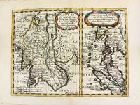
Nicolas Sanson (1600-1667)
Partie de L'inde au dela du gange; Presqv-Isle de L'inde au dela du gange.
Paris. 1652. Very Good. Notes: Fine 17th century map of Thailand Burma and Malaysia.<br><br> Size : 191x249 mm 7.50x9.80 Inches Coloring: Original Hand Coloring Category: Maps Asia South East Thailand Laos Vietnam Cambodia & Burma / Myanmar; Maps Asia South East Malaysia & Singapore; unknown
Bookseller reference : M8177
|
|
|
N Sanson
Anaplus Bosphori Thracii ex indagationibus Petri Greece Delineatus a Gulielmo sanson nic filio regis christianissimi geographo Lutetia Parisiorum Apud Petrum Mariette Via Iacobaea sub signo spei cum privilegio ad 20 annos
Paris : Pierre Mariette c. 1696. Very Good. Notes: Fine detailed map of the straight of the Bosphorus and the city of Constantinople. Size : 405x528 mm 15.94x20.79 Inches Coloring: Hand Colored Category: Maps Asia Near East Turkey; Pierre Mariette unknown
Bookseller reference : M8798
|
|
|
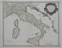
Sanson, Nicolas d'Abbeville - Jaillot, Hubert
L'Italie distinguee suivant l'estendue de tous Les Estats Royaumes Republiques Duches Principautes &c.
Paris: H. Jaillot c.1783. Very Good. Size : 469x655 mm 18.46x25.79 Inches Coloring: Original Hand Coloring Category: Maps Europe Italy; Maps Mediterranean Islands; H. Jaillot unknown
Bookseller reference : M10279
|
|
|
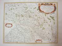
Sanson, Nicolas d'Abbeville
Partie Meridionale des Estats de Savoye ou sont le Dvche de Savoye les Comtes de Tarentaise et Morienne et partie du Bvgey &c
Paris: Mariette Pierre 1663. Excellent. Size : 425x575 mm 16.75x22.625 Inches Coloring: Hand Colored Category: ; Maps Europe France Mariette, Pierre unknown
Bookseller reference : M1708
|
|
|
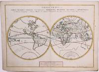
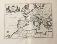
Nicolas Sanson
Orbis Vetus et Orbis Veteris Utraque Continens Terrarum Tractus Arcticus et Antarcticus ex Platone.
Amsterdam: Covens & Mortier c.1696. Very Good. Size : 393x540 mm 15.47x21.26 Inches Coloring: Original Hand Coloring Category: Maps World; Covens & Mortier unknown
Bookseller reference : M10191
|
|
|
Jaillot; Sanson
Forteresse de Zante
Paris c.1690. Very Good. Notes: A charming map of Forteresse de Zante Greece during the late 17th century. Size : 104x154 mm 4.09x6.06 Inches Coloring: Hand Colored Category: Maps Europe Greece Macedonia; unknown
Bookseller reference : M9475
|
|
 Receive by email
 Download as PDF document
 RSS feed


