|
PROVOST Michel, CHEVROT Jean François, TROADEC Jacques, HOLMGREN Jean.
Carte archéologique de la Gaule. Le Cher : 18.
1992 Paris : Académie des inscriptions et belles lettres, 1992; in-4° broché, couverture de papier couché fort bleu illustrée en couleurs, titre en blanc au dos et 1er plat; 370pp. Illustré en noir de photographies, dessins, relevés, plans et cartes.
Bookseller reference : 9474
|
|
|
Prof. Christ. Friedr. Ludwig Förster (Hrsg.)
Allgemeine Bauzeitung mit Abbildungen,. Siebzehnter Jahrgang. 1852. NUR der TEXTBAND !
Wien, L. Försters artistische Anstalt, 1852. 388 Seiten mit gestochenen Textabbildungen und Tafeln. Originalpappband.
Bookseller reference : 139439

|
|
|
Profumo, Maria Cecilia e Mennella, Giovanni
Tortona paleocristiana. Fonti - topografia - documentazione epigrafica. Prefazione di Colette Dufour Bozzo.
<p>24 cm, brossura editoriale, p. 229. Con 83 illustrazioni in nero f.t.</p>
|
|
|
PROUD Keith
Durham City.
8vo., First Edition, with illustrated title-spread, numerous illustrations in the text and front and rear endpaper maps; original terracotta cloth, gilt back, a near fine copy in unclipped dustwrapper.

|
|
|
PRUNETI Paola
I Kleroi del nomo Ossirinchite
Milano, Aegyptus 1975 86pp., 24cm., extract from the periodical "Aegyptus" 55 nr.1-4
Bookseller reference : C65481
|
|
|
PRUNETI Paola
I Kleroi del nomo Ossirinchite
86pp., 24cm., extract from the periodical "Aegyptus" 55 nr.1-4
|
|
|
Prusek, Jaroslav.
Chinese History and Literature: Collection of Studies.
Crown quarto. Pp. 586; Hardcover, bound in the original publisher's full light blue cloth, large gilt decoration to cover, gilt lettering to spine, with good dust-jacket, cloth ribbon marker, small marks on free endpapers. In fine condition. Overall an excellent copy. ~ First edition.
|
|
|
Pruyssenaere, E. de
Reisen und Forschungen im Gebiete des Weissen und Blauen Nil nach seinen hinterlassenen Aufzeichnungen bearbeitet und heraugegeben von K. Zöppritz. 1. und 2. Hälfte. [Hrsg.:] Petermann, August. [Mittheilungen [Mitteilungen] aus Justus Perthes' Geographischer Anstalt über wichtige neue Erforschungen auf dem Gesammtgebiete [Gesamtgebiete] der Geographie. Ergänzungsheft. Nr. 50 und 51].
Gotha, Justus Perthes 1877. 4°. 38; 48 pp., 2 Karten in Imperial-Folio, 1 Titelbild [So komplett]. Neuere Interimsbroschur. Vom Schnitt her etwas angestaubt.
Bookseller reference : 6045966
|
|
|
Przewalsky, N. M
Reise des russischen Generalstabs-Obersten N. M. Przewalsky von Kuldscha über den Thian-Schan an den Lob-Nor und Altyn-Tag 1876 und 1877. Übersetzung des an die K. Russ. Geographische Gesellschaft in St. Petersburg gerichteten offiziellen Berichtes von Przewalsky, d. d. Kuldscha 18. August 1877 . [Hrsg.:] Petermann, August. [Mittheilungen [Mitteilungen] aus Justus Perthes' Geographischer Anstalt über wichtige neue Erforschungen auf dem Gesammtgebiete [Gesamtgebiete] der Geographie. Ergänzungsheft Nr. 53].
Gotha, Justus Perthes 1878. 4°. 31 pp., 2 farbige Karten in Folio [So komplett]. Neuere Interimsbroschur. Vom Schnitt her etwas angestaubt.
Bookseller reference : 6045968
|
|
|
PRÆSTØ - NIELSEN, N.V.
Præstø Købstads og Klosters Historie. For Størstedelen efter utrykte Kilder.
Kbhvn., 1899. Samt. hldrbd. 477,(2) pp.
|
|
|
Prévot (E.) et Quanon (E.)
Notions de topographie - Levé des plans et nivellement
Eyrolles, éditeur à Paris Malicorne sur Sarthe, 72, Pays de la Loire, France 1951 Book condition, Etat : Bon broché, sous couverture imprimée éditeur blanche grand In-8 1 vol. - 167 pages
Bookseller reference : 86446
|
|
|
Prévot A.
Notions élémentaires sur les surfaces topographiques et applications aux cartes de France au 1:80000 et au 1:50000
Librairie Vuibert Relié 1934 In-8 (14,8 x 23,5 cm), reliure pleine-toile, dos lisse, pièce de titre, 37 pages, avec deux cartes dont une en couleur ; mouillure sur les bords des premiers feuillets, papier bruni, par ailleurs assez bon état. Livraison a domicile (La Poste) ou en Mondial Relay sur simple demande.
Bookseller reference : vg325
|
|
|
Préfecture de la Seine, Direction des services d'architecture et d'urbanisme, Inspection générale des servives techniques de topographie et d'urbanisme
OPÉRATIONS DE VOIRIE. 2éme édition Octobre 1951. Modification Janvier 1953. échelle : 1 / 10.0000
0 Un plan de Paris en couleurs replié : 134 cm x 108 cm. ( présence de quelques rousseurs et brunissures, petite fente à plusieurs plis, salissure marginale en bordure inférieure).
Bookseller reference : 028793
|
|
|
Prévot (Eugène) et Roux (O.)
Topographie - Instruments topographiques suivi d'un appendice relatif à la topographie expédiée par O. Roux - Livre 1. Instruments, description, manoeuvre, vérification, réglage et précision
Dunod , Bibliothèque de l'Ingénieur en Travaux Publics Malicorne sur Sarthe, 72, Pays de la Loire, France 1925 Book condition, Etat : Bon relié, cartonnage éditeur, pleine toile bordeaux imprimée, titre dorés fort In-8 1 vol. - 559 pages
Bookseller reference : 101240
|
|
|
Pröckl, Vincenz
Eger und Das Egerland. Historisch, statistisch und topographisch dargestellt. ERSTER und ZWEITER Band in einem Band. ERSTAUSGABE.
Verlag: Prag u. Eger, Selbstverlag, in Commission bei Kobrtsch & Gschihay in Eger u. Haase in Prag,, 1845, 1845. XIV, 342, 11 Abbildungen, 382 Seiten, 2 Seiten (Druckfehler) BAND I : 8 von 11 ?? ( so im Titel) Abbildungen, mit 3 ausfaltbaren Karten, 2 Ansichten ( Eger), 4 kolorierten Uniform- und Trachtentafeln und 2 Münz- und Siegeltafeln BAND II : 2 farbige Tafeln ( Plunderwagen der Egerländer, Hochzeit) 1 Plan Eger, 1 Plan Kammerbühl, 3 Ansichten ( Eger, Franzensquelle Seeberg). [3 Warenabbildungen]
Bookseller reference : 311521

|
|
|
Prüsker, Arthur
Der Tangentometer. Seine Einrüchtung, Rectification und Anwendung zum Höhenmessen und Nivellieren.
Wien, Lehmann & Wentzel [1879]. 31 S., mit 5 Holzschnitten u. 2 Tafeln, OKart. m. Rückenverklebung, abgegriffen, ausgeschied. Bibl.-Expl. mit den üblichen Kennzeichnungen.
Bookseller reference : MATH0521
|
|
|
PUGH Christine
Stockbury. A Regional Study in North-East Kent.
8vo., First Edition, with frontispiece, illustrated title and 5 large folding maps and charts on japon; strongly bound in boards, upper board with paper label, ORIGINAL PRINTED WRAPPERS PRESERVED, a very good, clean copy. With the errata slip mounted before frontispiece. Bennett, p.340.
|
|
|
PUILLE, D.
Cour complet. Arpentage élémentaire, théorique et appliqué à l’usage des divers établissements d’instruction publique. Nouvelle édition, revue et augmentée.
Paris, Ch. Fouraut sans date, vers 1851, 180x110mm, VIII - 352pages, relié demi-cuir, dos muet, rousseurs taches d’eau.
Bookseller reference : 27258
|
|
|
Puille (D.) d'Amiens
Traité complet de la division des champs dans tous les cas - Géodésie usuelle comprenant toutes les méthodes arithmétiques et géométriques pour diviser les terrains d'une forme régulière et irrégulière en portions équivalentes et proportionnelles d'après les différentes conditions imposées par les copartageants - Ouvrage rédigé à l'usage des géomètres-arpenteurs de profession et des amateurs d'applications géométriques (Nouvelle édition revue avec soin et augmentée)
Librairie classique de Ch. Fouraut et Fils, à Paris Malicorne sur Sarthe, 72, Pays de la Loire, France 1880 Book condition, Etat : Moyen broché, sous couverture imprimée éditeur crème In-8 1 vol. - 336 pages
Bookseller reference : 85776
|
|
|
PUISSANT Louis
PRINCIPES DU FIGURE’ DU TERRAIN ET DU LAVIS SUR LES PLANS ET CARTES TOPOGRAPHIQUES. Susceptibles de servir de base à l’enseignement du dessin dans les Ecoles des Services Publics, et comparaison des différens modes proposés à ce sujet.
In-8 p. (mm. 221x136), brossura orig., pp. (4),III,132, e 1 tavola f.t., inc. in rame e ripieg., con 7 figure. In Appendice (a partire da p. 95) “nouvelles tables géodésiques relatives à la construction de ces cartes”. "Edizione originale" di questo studio di Louis Puissant “Lieutenant -Colonel au Corps Royal des Ingénieurs-Géographes”. Con solo qualche rara fiorit. ma buon esemplare con barbe.

|
|
|
PULLAN B.
A History of the University of Manchester 1951-73. History of the University of Manchester 1951-73.
8vo., First Edition, with 21 plates; red cloth, upper board and backstrip lettered in gilt, yellow endpapers, a near fine copy.

|
|
|
Pulleyblank, Edwin G.
The Background of the Rebellion of An Lu-Shan. (London Oriental Studies, 4).
Octavo. Pp. x, 264. Plus 2 folding maps bound at end, and a folding chart bound-in. Hardcover, bound in the original publisher's full cloth, gilt spine; free endpapers browned, first with a signature. In fine condition. Excellent copy. ~ First edition. London Oriental Studies, 4. Rare original copy.
|
|
|
PUPPI LIONELLI (a cura di)
Ritratto di Verona.
In 4° (310x210); pagg. XXXI, 652 con una grande tavola ripiegata fuori testo raffigurante una veduta di Verona di Marco Moro, XV illustrazioni a col. , XXI in nero, 341 in nero di stampe e piante della città, particolari architettonici, monumenti ecc.Interessante bibliografia sulle vedute, piante e carte geogr. di Verona con dettagliate schede Contiene saggi di Marchi, Lorenzoni, Brugnoli, Marchini, Concina, mazzi, Borelli ed altri. Tela editoriale con sovracoperta a colori e custodia. Contiene interessanti saggi di storia veneta, architettura, istituzioni civili e sociali. Come nuovo.
|
|
|
PURCHAS A.W.
Some History of Wells-next-the-Sea and District.
8vo., First Edition, with 12pp of plates, 3 full-page maps and tables in the text; green cloth, gilt back, a very good, clean copy. Scarce. Darroch & Taylor, 6791
|
|
|
PUREFOY [Elizabeth]
The Purefoy Letters 1735-1753. Edited by L. G. Mitchell. NEAR FINE COPY IN UNCLIPPED DUSTWRAPPER
Roy. 8vo., First Edition; cloth, gilt back, a near fine copy in unclipped dustwrapper. Elizabeth Purefoy lived and worked for ninety years in the village of Shalstone, Buckinghamshire. Her letters provide a fascinating picture of life ion provincial England in the eighteenth century.
|
|
|
PUREY-CUST, ed. A.P.
Our English Minsters. With Illustrations by Herbert Railton and Others. First and Second Series. BRIGHT SET IN ORIGINAL CLOTH
2 vols., 8vo., First Edition, with frontispieces and numerous illustrations (a number full-page)| in the text; original red cloth, upper boards blocked and lettered in gilt, gilt backs, uncut, a good, bright, clean set. COMPLETE SETS IN THIS CONDITION ARE SCARCE.
|
|
|
Puyraimond, Jeanne-Marie; Walter Simon; Marie-Rose Séguy.
Catalogue du Fonds Mandchou.
Royal octavo. Pp. 178. Plus 6 plates. Indices. Original errata slip tipped-in. Bound in the original stiff wrappers. In fine condition. ~ First edition.
|
|
|
PYATT Edward C
Chalkways of South and South-East England. Maps compiled by Gillian Pyatt. NEAR FINE COPY IN UNCLIPPED DUSTWRAPPER
8vo., First Edition, with plates and maps; green cloth, gilt back, a near fine copy in unclipped dustwrapper. With appendices on archaeology, birds, flowers and official paths.

|
|
|
PYATT Edward C.
Coastal Paths of the South West. NEAR FINE COPY IN DUSTWRAPPER
8vo., First Edition, with plates and maps; blue cloth, gilt back, a near fine copy in price-clipped dustwrapper.

|
|
|
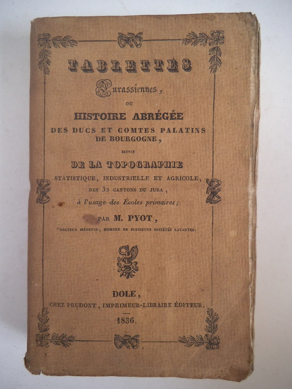
PYOT M.
Tablettes Jurassiennes
ou histoire abrégée des Duc et Comtes Palatins de bourgogne suivie de la topographie statistique , industrielle et agricole des 32 cantons du Jura ; A l’usage des écoles primaires. In 12 broché couverture imprimée faux-titre,carte du département du jura divisé en 32 cantons au verso,titre, (signature de l’auteur)248 pages,catalogue,Dijon 1836 (très pâle mouillure en pied au milieu du volume sans gravité) sinon bon exemplaire
Bookseller reference : 2493
|
|
|
Pörtner, Rudolf
Das Römerreich der Deutschen : Städte u. Stätten d. dt. Mittelalters.
München [u.a.] : Droemer Knaur, 1970. 441 S. 72 Abb., Kt. 8°. [Nachaufl.]. OKt. (Tb). (Knaur ; 227)
Bookseller reference : 45754
|
|
|
QUEISER, Adalbert
Geschichte der Stadt Amstetten von den ältesten Zeiten bis auf die Gegenwart. Nach historischen Quellen bearbeitet.
Amstetten, Queiser 1898. VIII, 168 Seiten. Mit einigen Abb. im Text. OHLn., papierbedingt gebräunt, stellenw. etwas fleckig, Deckel berieben. Im Ganzen noch akzeptables Exemplar der gesuchten Darstellung. Freisinger III, 3036. Erste Ausgabe.
Bookseller reference : AUST1039
|
|
|
Queiser, Adalbert
Wallsee an der Donau. Geschichtliche Darstellung von Schlosz und Herrschaft Wallsee ältester und neuester Zeit.
Amstetten, Queiser 1895. 41 nn. Bl., 2 Portr., 1 Taf., OBrosch. Erste Ausgabe
Bookseller reference : AUST1595
|
|
|
QUENNELL C.H.B.
Somerset. Shell Guide. [Edited by John Betjeman. First Faber edition], BRIGHT, CLEAN COPY OF THE FIRST FABER EDITION
4to., First Edition thus, with numerous plates on green stock, photographs (many full-page) in the text, 2 full-page coloured maps and patterned endpapers; original ivory cloth, backstrip blocked in red and lettered in white, comb-bound as issued, covers lightly spotted (as often), a very good, bright, clean copy. Originally published by Architectural Press in 1936, this one of the first ten titles in this wonderful series edited by Betjeman (see Peterson D4). In 1939 the imprint passed to Faber who replaced the characteristic comb-binding with conventional cloth and standardised the titles. VERY SCARCE, ESPECIALLY IN THIS CONDITION.

|
|
|
Quilici Lorenzo e Quilici Gigli Stefania
Introduzione alla topografia antica.
pp. 210, cm 21x14, brossura. Nuovo.
|
|
|
Quilici Lorenzo, Quilici Galli Stefania (a cura)
Città dell'Umbria
<p>26 cm, cartoncino editoriale con sovracop. illustrata; p. 218, numerose illustrazioni, foto, disegni e tavole archeologiche nel testo, e tre carte archeologiche più volte ripiegate</p>

|
|
|
Quilici Lorenzo, Quilici Gigli Stefania (a cura)
Agricoltura e commerci nell'Italia antica
<p>26 cm, cartoncino editoriale con sovracop. illustrata; p. 296, numerose illustrazioni in nero, disegni e foto, numerose carte archeologiche</p>

|
|
|
Quilici Lorenzo, Quilici Gigli Stefania (a cura)
Architettura e pianificazione urbana nell'Italia antica
<p>26 cm, cartoncino editoriale con sovracop. illustrata; p. 260, numerose figure in nero, foto e disegni e diverse carte archeologiche a piena pagina </p>

|
|
|
Quilici Lorenzo, Quilici Gigli Stefania (a cura)
Campagna e paesaggio nell'Italia antica
<p>26 cm, cartoncino editoriale con sovracop. illustrata; p. 252, numerose figure in nero, foto e disegni.diverse carte archeologiche</p>

|
|
|
Quilici Lorenzo, Quilici Gigli Stefania (a cura)
Carta archeologica e ricerche in Campania. Fascicolo 1: Comuni di Alvignano, Baia e Latina, Caiazzo, Castel Campagnano, Castel di Sasso, Dragoni, Piana di Monte Verna, Ruviano
<p>26 cm, cartoncino editoriale con sovracop. illustrata; p. 451, numerose figure in nero, alcune a colori e numerose carte archeologiche a piena pagina color rosso, in fine 5 tavole archeologiche a colori più volte ripiegate</p>

|
|
|
Quilici Lorenzo, Quilici Gigli Stefania (a cura)
Carta archeologica e ricerche in Campania. Fascicolo 2: Comuni di Brezza, Capua, San Prisco
<p>26 cm, cartoncino editoriale con sovracop. illustrata; p. 235, numerose figure in nero, foto e disegnidi reperti archeologici e numerose carte archeologiche a piena pagina color rosso,una tavola archeologica più volte ripiegata</p>

|
|
|
Quilici Lorenzo, Quilici Gigli Stefania (a cura)
Carta archeologica e ricerche in Campania. Fascicolo 3: Comuni di Airola, Arienzo, Arpaia, Castel di Sasso, Cervino, Durazzano, Forchia, Formicola, Liberi, Maddaloni, Pontelatone, Roccarainola, S. Felice a Cancello, S. Maria a Vico
<p>26 cm, cartoncino editoriale con sovracop. illustrata; p. 389, numerose figure in nero, foto e disegnidi reperti archeologici e numerose carte archeologiche a piena pagina. In fine,due avole archeologica più volte ripiegate, una di Caserta</p>
|
|
|
Quilici Lorenzo, Quilici Gigli Stefania (a cura)
Città e monumenti nell'Itali antica
<p>26 cm, cartoncino editoriale con sovracop. illustrata; p. 304, numerose figure in nero, foto e disegni.Diverse carte archeologiche a piena pagina anche a colori</p>

|
|
|
Quilici Lorenzo, Quilici Gigli Stefania (a cura)
Edilizia pubblica e privata nelle città romane
<p>26 cm, cartoncino editoriale con sovracop. illustrata; p. 293, numerose figure, disegni e foto in nero e a colori, alcune carte archeologiche a piena pagina a colori. Inserito biglietto con dedica del curatore</p>
|
|
|
Quilici Lorenzo, Quilici Gigli Stefania (a cura)
La forma della città e del territorio - 2
<p>26 cm, cartoncino editoriale con sovracop. illustrata; p. 263, numerose illustrazioni in nero e a colori, numerose carte archeologiche, di cui due più volte ripiegate</p>

|
|
|
Quilici Lorenzo, Quilici Gigli Stefania (a cura)
La forma della città e del territorio - 3
<p>26 cm, cartoncino editoriale con sovracop. illustrata; p. 243, numerose figure in nero, alcune a colori e carte archeologiche a piena pagina color seppia, una ripiegata</p>

|
|
|
Quilici Lorenzo, Quilici Gigli Stefania (a cura)
La via Appia. Iniziative e interventi per la conoscenza e la valorizzazione da Roma a Capua
<p>26 cm, cartoncino editoriale con sovracop. illustrata; p. 174, numerose illustrazioni in nero, foto e disegnii, alcune carte archeologiche, una tavola più volte ripiegata</p>

|
|
|
Quilici Lorenzo, Quilici Gigli Stefania (a cura)
Santuari e luoghi di culto nell'Italia antica
<p>26 cm, cartoncino editoriale con sovracop. illustrata; p. 407, numerose figure in nero di divinità e diverse carte archeologiche a piena pagina color rosso, due ripiegate</p>

|
|
|
Quilici Lorenzo, Quilici Gigli Stefania (a cura)
Strade romane: ponti e viadotti
<p>26 cm, cartoncino editoriale con sovracop. illustrata; p. 202, numerose illustrazioni in nero, disegni e foto , numerose carte archeologiche</p>

|
|
|
Quilici Lorenzo, Quilici Gigli Stefania (a cura)
Urbanizzazione delle campagne nell'Italia antica
<p>26 cm, cartoncino editoriale con sovracop. illustrata; p. 261, numerose illustrazioni in nero, foto e disegni, numerose carte archeologiche in rosso a piena pagina, di cui due più volte ripiegate</p>

|
|
 Receive by email
 Download as PDF document
 RSS feed


