|
CHINA MEDICINE / PUPPETS Heck G. drawn by. Henry Winkles sculpt.
Untitled scenes in China. PAIR OF ENGRAVINGS.
No date. Ca. 1851. Pair of steel engravings each 10 x 7 3/4 inches on 11 3/4 x 9 3/8 inches. Couple of small spots in outer margins light soiling. Each sheet features three scenes. Plate 24 includes a musician and two acrobats performing before a group of seated men; a scene of boats and a crowd of people gathered along a river front; a scene of corporal punishment. Plate 25 includes as lightly described in pencil on the sheet a puppet show; Chinese Mandarins visiting; and a "Chinese Quack" selling goods. . unknown
Bookseller reference : 51014

|
|
|
CHINA GREAT WALL Child G. engraved by.
View of ye Great Wall on ye side where ye Ambassador entered China.
London. 1745- 1747. Copperplate engraving plate area 7 1/4 x 14 3/4inches on sheet 10 1/4 x 16 1/2 inches three vertical folds as issued . Very faint offsetting to left panels very good condition. A striking view of the Great Wall of China near Chogon Koton ; the image is after the work of Joan Nieuhof whose 17th century views were amongst the earliest reliable reports of China. Nieuhof was traveling as a member of a Dutch East India embassy eager to establish trade relations with China. This engraving was published in an 18th century compendium of important travel writing: "A New General Collection of Voyages and Travels" published by Astley. . unknown
Bookseller reference : 45553

|
|
|
CHINA
"Land of Confucius" Shantung - China's "Holyland".
China Travel Service. No date. Ca. 1932. Booklet small color map black and white photo illustrations 22 panels 7 1/2 x 3 1/2 inches unfolding to 7 1/2 x 10 1/4 inches color pictorial covers softbound. Very good condition. This pamphlet advertises the China Travel Service with brief paragraphs on Shantung Tsowhsien Chufou Taianfu and Tai Shan Tsinanfu and Tsingtao. . China Travel Service. paperback
Bookseller reference : 46628

|
|
|
CHINA
Bridge of Chains in China.
London.: Thomas Kelly. No date. Ca. 1820s. Copper plate engraving image 5 3/4 x 8 inches on sheet 8 1/4 x 10 1/2 inches. Light toning and scattered foxing to margins image is clean and bright. A lovely distant view of a bridge connecting a rocky terrain with waterfalls. Figures gather in the foreground to talk and fish. . Thomas Kelly. unknown
Bookseller reference : 41330

|
|
|
CHINA
Untitled Chinese painting on silk - silkworms eating leaves on the branch of a berry tree.
No date. Ca. 1900. Chinese painting on silk image 10 1/2 x 10 1/2 inches mounted on sheet 13 1/2 x 12 inches. Apparently from an accordion fold portfolio; two punch holes at left edge image can be matted to cover these small holes; image in very good condition. An attractive original painting perhaps from a collection of patterns suitable for fans to the design. . unknown
Bookseller reference : 42618

|
|
|
CHINA OPIUM SMOKERS
An Opium Den in a Chinese City.
New York.: Harper's Weekly. 09-04- 1880. Wood engraving black and white single page from Harper's Weekly September 4 1880 image size 9 x 12 on sheet 11 x 16 1/4 inches. Light scattered foxing image unaffected soft vertical fold at center; good condition. Includes article "Opium Smoking in China" to the left of image and continued on verso. . Harper's Weekly. unknown
Bookseller reference : 39977

|
|
|
CHINA HUNAN PROVINCE & SURROUNDING Basire J. engraved by.
Cities of the Province of Hu-Quang.
No date. 1738. Copper plate engraved map 14 1/4 x 9 inches on sheet 16 x 10 inches. Short edge tear at lower edge well outside image very good condition. An attractive map depicting four walled cities of the Chinese Qing dynasty province of Hu-Quang modern day HUNAN and part of surrounding provinces: Vu-Chang-Fu Yong-Chew-Fu Whang-Chew-Fu and Syang-Yang-Fu. This is a plate from Du Halde's "A description of the empire of China and Chinese-Tartary: together with the kingdoms of Korea and Tibet: containing the geography and history natural as well as civil of those countries" published in London in 1738. Originally published in French in 1735 this was an encyclopedic compendium by Jesuit priest Jean Baptiste Du Halde of the written accounts of some 27 Jesuits in China documenting the history and customs of the country. . unknown
Bookseller reference : 50783

|
|
|
CHINA
The Present Manchurian Tangle.
New York.: Japanese National Committee. 1931. Booklet small black and white map 48pp 7 3/4 x 5 1/4 inches paper wrappers. Light soiling to covers with soft undulation to upper area of first pages although no sign of dampstaining; interior very good. Contains reports "Japanese Government Declaration of September 24 1931 on Manchurian Incident" "Japanese Government Declaration of October 26 1931 on Manchurian Incident" "Japan's Reply of November 6 1931 to League Council" and eleven editorials. . Japanese National Committee. unknown
Bookseller reference : 51036

|
|
|
CHINA CENTRAL ASIA
The National Geographic Magazine. 1926 - 02.
Washington D.C.: National Geographic Society. 02- 1926. February 1926 issue of the magazine in paper wrappers as issued 1/2 inch split to tail of spine very good condition. Interesting articles: "The Road to Wang Ye Fu. An Account of the work of the National Geographic Society's Central-China Expedition in the Mongol Kingdom" by Frederick R. Wulsin with 29 photo illustrations many showing people at work; "Scenes in the Celestial Republic" 16 full page black and white illustrations of China; "Rothenburg the City Time Forgot" by Charles W. Beck Jr. with 8 pages of full color illustrations; "Fishing for Pearls in the Indian Ocean" by Bella Sidney Woolf. . National Geographic Society. unknown
Bookseller reference : 28037

|
|
|
CHINA
China.
J.H. Colton. Copyright 1855. Map handcolored 11 3/4 x 14 1/2 inches on sheet 14 x 17 1/4 inches light toning in upper margin very light offset overall clean and bright. Two small uncolored insets- 'Map of Canton and Adjacent Islands' and 'Harbor & Island of Amoy'. Sheet number 93. . J.H. Colton. unknown
Bookseller reference : 38716

|
|
|
CHINA
China.
London.: G.F. Cruchley. No date. Ca. 1860. Engraving handcolored 9 x 11 3/4 on sheet 10 1/2 x 13 inches. A few tiny edge tears and light creases overall very good condition. An attractive color map with considerable detail along the coast many bays and points named and provinces colored. Shanghai is spelled Shanghae; Hong Kong and Victoria are marked "British." . G.F. Cruchley. unknown
Bookseller reference : 51073

|
|
|
RHODODENDRON CHINA Snelling L. drawn and lithographed by.
Rhododendron Griersonianum.
London.: The Royal Horticultural Society / Bernard Quaritch Ltd. 1930. Hand colored lithograph on sheet 10 x 11 1/2 inches centerfold as issued very good condition. With text sheet. This is one of Lilian Snelling's 1879-1972 exquisite botanical illustrations complete with botanical details. The geographic distribution of this rhododendron is described in the descriptive text as being from China Southwestern Yunnan. Plate 9195 from Curtis's Botanical Magazine from Volume CLIII Part IV. . The Royal Horticultural Society / Bernard Quaritch Ltd. unknown
Bookseller reference : 49366

|
|
|
CHINA / TAIWAN SURVIVAL MAP/ EVASION MAP/ ESCAPE MAP
AAF Cloth Map - Asiatic Series. No. 34. Southeast China. No. 35. Northeast China.
Washington D.C.: Army Map Service. 07- 1945. Two color maps 23 1/2 x 19 inches printed back to back on one cloth sheet 26 1/2 x 20 inches folded as issued. Very good clean condition. This is a "survival map" or "escape map" compiled for the U.S. Army Air Forces; these light-weight "silk" maps actually most were man-made fabrics were carried by military personnel with missions in enemy territory each map containing information crucial to facilitating escape to friendly territory. South China side has an inset of Taiwan Formosa. Winds and ocean currents are marked as well as much information on settlements and terrain. Appears to be a 1945 issue. Scale 1:2000000. Map No. 34 includes approximate coordinates: 112 to 122 degrees east and 22 to 32 degrees north showing the area from Hong Kong to Nan-ching Nanking. Map No. 35 includes approximate coordinates 109 to 123 degrees east and 30 to 38 degrees north. The map is stated at lower left as being compiled in 1943 but at lower right is the date 1944 and additional 'SF-3-45'. . Army Map Service. hardcover
Bookseller reference : 46961

|
|
|
CHINA GUANGDONG Basire J. engraved by.
The City of Nan-Hyong Fu. Nieuhof.
London. 1745- 1747. Copperplate engraving image 6 1/2 x 14 1/4 inches 17 x 36 cm on sheet 10 1/4 x 16 1/2 inches two vertical folds as issued fine condition. Very good clean condition with faint toning to left and upper edges outside plate area. A striking view of this city in the province of Guangdong central to the tea route leading to Canton Guangzhou after the work of Joan Nieuhof whose 17th century views were amongst the earliest reliable reports of China. Nieuhof was traveling as a member of a Dutch East India embassy eager to establish trade relations with China. This engraving was published in an 18th century compendium of important travel writing: "A New General Collection of Voyages and Travels" published by Astley. . unknown
Bookseller reference : 43858

|
|
|
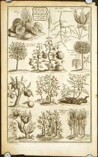
CHINA PLANTS Basire J. engraved by.
Untitled sheet of plants of China with notation: "This plate is inscribed to Edwd. Milward MD a worthy Promote of this Work."
No date. 1738. Copper plate engraving 14 x 8 1/2 inches on sheet 16 x 10 inches. A few short edge tears two soft creases at the left edge good condition. A fascinating montage illustration of eleven plants found in China: Rhubarb Jinseng cotton trees tong shu or the varnish tree Lichi Tea shrub Fu lin Jaca Betel bambus bamboo. This is a plate from Du Halde's "A description of the empire of China and Chinese-Tartary: together with the kingdoms of Korea and Tibet: containing the geography and history natural as well as civil of those countries" published in London in 1738. Originally published in French in 1735 this was an encyclopedic compendium by Jesuit priest Jean Baptiste Du Halde of the written accounts of some 27 Jesuits in China documenting the history and customs of the country. . unknown
Bookseller reference : 50786
|
|
|
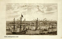
CHINA CANTON / GUANGZHOU Child G. engraved by.
The City Quang Chew Fu or Kanton from Nieuhof.
London. 1745- 1747. Copperplate engraving image 7 x 11 1/2 inches 18 x 29 cm on sheet 10 1/4 x 15 inches two vertical folds as issued fine condition. A striking view of the important trade city of Canton one of the first treaty ports. The harbor is a riot of activity with ships of all sizes and shapes; the image is after the work of Joan Nieuhof whose 17th century views were amongst the earliest reliable reports of China. Nieuhof was traveling as a member of a Dutch East India embassy eager to establish trade relations with China. This engraving was published in an 18th century compendium of important travel writing: "A New General Collection of Voyages and Travels" published by Astley. . unknown
Bookseller reference : 43859
|
|
|
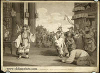
CHINA THEATRE Alexander del. J. Heath sculp.
A Scene in an Historical Play exhibited on the Chinese Stage.
London.: G.Nicol. April 12 1796. Copper-plate engraving image approximately 9 1/2 x 13 3/4 inches on sheet size 10 1/2 x 14 1/2 inches trimmed close to image on three sides. Overall light soiling soft crease to lower left and right corner outside image area small chip to lower left corner not affecting image tight margins at all sides. One of the detailed and elegant engravings after drawings by William Alexander published in Sir George Staunton's two-volume "Account of the Embassy from the King of Great Britain to the Emperor of China" published in London 1796-97. . G.Nicol. unknown
Bookseller reference : 42936
|
|
|
CHINA BIRDS Keulemans JG. drawn and lithographed by. J. G.
Suthora Davidiana. Cryptolopha Ricketti.
London.: Ibis. 1897. Lithographed handcolored with gum arabic highlights sheet size 8 1/2 x 5 1/2 inches 21.5 x 14cm. Very good condition. Exquisitely drawn and lithographed image of two birds from Fujian province of China. . Ibis. unknown
Bookseller reference : 47762

|
|
|
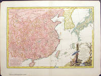
CHINA Bonne Rigobert.
L'Empire de la Chine d'apres l'Atlas Chinois avec les isles du Japon. Par M. Bonne Hydrographe du Roi au Bureaus de la Marine.
Paris. 1791. Copperplate engraving full modern handcolor 12 1/4 x 17 1/2 inches on sheet 15 1/4 x 20 1/2 inches centrefold as issued. Pinhead sized hole at two lower corners one foxing spot in the sea east of Nanking overall fine condition. A detailed yet very decorative map including not only China but also Formosa Taiwan Hainan Korea Coree and Japan Niphon. At lower centre is also the tip of the Philippine Islands. Oriental style cartouche at lower right. . unknown
Bookseller reference : 40012
|
|
|
CHINA DECORATIVE ART
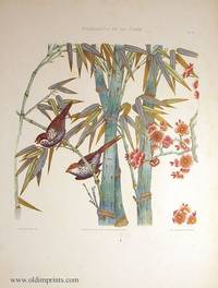
Ornements de la Chine. Plate 28. Decorative design of birds in bamboo.
Paris.: Canson Libraire-Editeur. 1883. Chromolithograph image area approximately 15 x 14 inches on sheet 24 1/2 x 18 inches. Light soiling in margins watercolor drip below image overall very good condition. A particularly attractive painterly image of two birds in setting of bamboo and pink blossom branches richly colored with gold design work. This is plate 28 from the exquisitely printed French portfolio Ornements de la Chine Recueil de Dessins Pour l'Art et l'Industrie par E. Collinot et A. De Beaumont featuring Chinese ornament of which only 500 copies were issued. . Canson, Libraire-Editeur. unknown
Bookseller reference : 38105
|
|
|
CHINA Mallet AM. A. M.
Der Pallasi zu Peking.
Ca. 1685. Engraving image 5 1/2 x 4 inches on sheet 8 x 5 1/2 inches. Very good condition. From an edition of Alain Manesson Mallet's Description de L'Univers. . unknown
Bookseller reference : 43935

|
|
|
CHINA NANJING Basire J. engraved by.
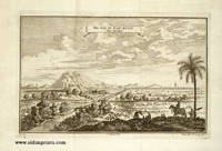
The City of Nan-King from Nieuhof.
London. 1745- 1747. Copperplate engraving image 7 1/2 x 11 3/4 inches 18 x 30 cm on sheet 10 1/4 x 16 1/2 inches two vertical folds as issued fine condition. A striking panoramic view of the walled city of Nanking / Nanjing after the work of Joan Nieuhof whose 17th century views were amongst the earliest reliable reports of China. Nieuhof was traveling as a member of a Dutch East India embassy eager to establish trade relations with China. This engraving was published in an 18th century compendium of important travel writing: "A New General Collection of Voyages and Travels" published by Astley. . unknown
Bookseller reference : 43848
|
|
|
CHINA BEIJING TEMPLES Fletcher H. engraved by.
Plan of the Tyen-tang or Temple Dedicated to the Sovereign Lord of Heaven. Plan of the Ti-tang or Temple Where the Empero Sacrifices to Shang-ti under the title of Sovereign Lord of the Earth. / Plan of the Ti vang myau.Plan of the Que tse Kyen.
No date. 1738. TWO SHEETS of copper plate engraved maps approximately 14 1/4 x 8 1/2 inches on sheets 16 x 10 inches. Light toning slight wave to paper tiny "pimple" in paper at upper right of first image overall very good condition. One sheet shows plans of the Tyen-tang temple and the Ti-tang temple; the other sheet shows a plan of the Ti vang myau or Hall of Ceremony and a plan of the Que tse Kyeu or Hall of Ceremony. Beneath these two latter plans are extensive explanations. These sheets are from Du Halde's "A description of the empire of China and Chinese-Tartary: together with the kingdoms of Korea and Tibet: containing the geography and history natural as well as civil of those countries" published in London in 1738. Originally published in French in 1735 this was an encyclopedic compendium by Jesuit priest Jean Baptiste Du Halde of the written accounts of some 27 Jesuits in China documenting the history and customs of the country. . unknown
Bookseller reference : 50791

|
|
|
CHINA PEKING Fletcher H. engraved by.
Cities of the Province of Pe-Che-Li.
No date. 1738. Copper plate engraved map 14 1/4 x 8 1/2 inches on sheet 16 x 10 inches. Area of light discoloration at the left upper margin not affecting the image soft undulation to paper very good condition. An attractive map depicting walled cities of the Chinese Qing dynasty province of Pe-Che-Li modern day Hebei province. At upper right is a plan of Peking with "explanation" at left; other cities are Yung-ping-fu; Long-men-hyen; Chin-ting-fu; and a "Plan of part of the great wall on the Side of Yung-ping-fu flank'd by several fortresses." This is a plate from Du Halde's "A description of the empire of China and Chinese-Tartary: together with the kingdoms of Korea and Tibet: containing the geography and history natural as well as civil of those countries" published in London in 1738. Originally published in French in 1735 this was an encyclopedic compendium by Jesuit priest Jean Baptiste Du Halde of the written accounts of some 27 Jesuits in China documenting the history and customs of the country. . unknown
Bookseller reference : 50794

|
|
|
CHINA SILK MANUFACTURE Parr N. engraved by.
The Silk Manufacture from Du Halde. SET OF TWO ENGRAVINGS.
London. 1745- 1747. TWO copperplate engravings images 6 1/2 x 8 1/4 inches 16 x 21 cm on sheets 8 x 10 inches fine condition. Each engraving shows several stages of the production of silk. This engraving was published in an 18th century compendium of important travel writing: "A New General Collection of Voyages and Travels" published by Astley. . unknown
Bookseller reference : 43862

|
|
|
CHINA Davidson J. O. illus.
A Chinese Junk Village.
New York.: Harper's Weekly. 05-20- 1882. Half page wood engraving from May 20 1882 issue of Harper's Weekly black and white 7 x 9 1/8 on sheet size 10 1/2 x 16 inches. A couple of mended short edge tears outside image area. Very good condition. Engraving by J. O. Davidson accompanied with three columns of text "A Chinese Junk Village." . Harper's Weekly. unknown
Bookseller reference : 40642

|
|
|
CHINA RELIGION Basire I. engraved by.
Priests or Monks of Fo from Nieuhof.
London. 1745- 1747. Copperplate engraving image 5 3/4 x 8 inches 15 x 20 cm on sheet 8 x 10 1/4 inches fine condition. Image of four men priests and monks after the work of Joan Nieuhof whose 17th century views were amongst the earliest reliable reports of China. Nieuhof was traveling as a member of a Portuguese embassy eager to establish trade relations with China. This engraving was published in an 18th century compendium of important travel writing: "A New General Collection of Voyages and Travels" published by Astley. . unknown
Bookseller reference : 44178

|
|
|
CHINA DECORATIVE ART
Ornements de la Chine. Plate 14. Group planting chrysanthemums in rocky terrain.
Paris.: Canson Libraire-Editeur. 1883. Chromolithograph image area approximately 13 x 10 inches on sheet 25 x 17 3/4 inches. Very good condition: light soiling to upper left and right corners and lower margin all outside image area soft creasing to upper right corner image very bright and clean. Richly colored with an attractive landscape. This is plate 14 from the portfolio Ornements de la Chine Recueil de Dessins Pour l'Art et l'Industrie par E. Collinot et A. De Beaumont of which only 500 copies were issued. . Canson, Libraire-Editeur. unknown
Bookseller reference : 41502

|
|
|
CHINA GUANGZHOU Kitchin Thos. engraved by.
The Water-Castle at Canton.
London. 1745- 1747. Copperplate engraving image 6 x 8 inches on sheet size 15 x 9 1/4 inches. 1/2 inch tear to mid upper edge well outside image area; very good clean condition. An image of the "water-castle" at top with music for "Chinese Airs from du Halde" in lower half. This engraving was published in Thomas Salmon's Universal Gazetteer in 1791 after Arnoldus Montanus the 17th century Dutch teacher and author. . unknown
Bookseller reference : 51029

|
|
|
CHINA TIENSIN / TIANJIN SECOND OPIUM WAR
Gunboats of the Allied Fleets. TOGETHER WITH Procession of the Plenipotentiaries and Ceremony of Signing the Treaty of Tien-Sin.
Illustrated Times. 1858. TWO SHEETS FROM ISSUES OF THE ILLUSTRATED TIMES with wood-engraved illustrations each sheet 15 x 10 inches. Very good condition. Two sheets with text and illustrations relating to the Second Opium War. The September 18 sheet has two illustrations: "Gunboats of the Allied Fleets aground in the Peiho River" and "Gunboats of the allied Fleets Arriving at Tien-Tsin" with related text. The November 6 issue is a collage-like illustration from a sketch by M. Roux with the military procession surrounding an illustration of the signing ceremony. . Illustrated Times. unknown
Bookseller reference : 50254

|
|
|
CHINA NANJING White H. C. photo byCHIN
Interior of Dr. Sun Yat Sen's Mausoleum. / General View of Dr. Sun Yat Sen's Mausoleum. PAIR OF ROTOGRAVURES.
China Rotogravure Company. No date. Ca. 1930. PAIR of black and white rotogravures each approximately 11 x 16 inches. Light wear to right edge outside image area mended 1 inch tear to mid lower edge of each image otherwise very good condition. Attractive images by H. C. White showing the interior and exterior of Dr. Sun Yat Sen's Mausoleum in Nanjing China. . China Rotogravure Company. unknown
Bookseller reference : 44224

|
|
|
CHINA CUSTOMS
Life in China. PAIR OF WOOD ENGRAVINGS.
New York.: Harper's Weekly. 07-26 1873. Full page and three-quarter page wood engravings from July 26 1873 issue of Harper's Weekly black and white sheet size 11 x 16 inches. Very good condition. The full page image features 6 vignette illustrations: Death in the Cage Conveying Prisoners to the Lock-up Coolies A Mendicant The Rain-coat and Convicts. The three-quarter page "The Feast of Lanterns" includes a brief text article describing both engravings in the lower margin which continues on the verso of sheet. . Harper's Weekly. unknown
Bookseller reference : 49039

|
|
|
CHINA Child G. sculp.
The Lou-Wa or Fishing Bird with the manner of fishing from Nieuhof.
circa 1800. Copper engraving modern handcolor image 5 1/2 x 7 1/2 inches on sheet 8 1/4 x 10 1/2 inches. Light soiling in margins. A lovely image of a sitting bird in the foreground with a vast landscape and fishing boats in the distance after the work of Joan Nieuhof whose 17th century views were amongst the earliest reliable reports of China. Nieuhof was traveling as a member of a Portuguese embassy eager to establish trade relations with China. No. 123. Plate XI. Vol.III.p.137. . unknown
Bookseller reference : 40310

|
|
|
CHINA SHAOGUAN Child G. engraved by.
The city Shau-Chew-Fu from Nieuhof.
London. 1745- 1747. Copperplate engraving image 7 3/4 x 12 1/4 inches 19 x 31 cm on sheet 10 1/4 x 16 inches two vertical folds as issued fine condition. A view of the walled city of Shaoguan some 100 miles north of Canton / Guangzhou; after the work of Joan Nieuhof whose 17th century views were amongst the earliest reliable reports of China. Nieuhof was traveling as a member of a Dutch East India embassy eager to establish trade relations with China. This engraving was published in an 18th century compendium of important travel writing: "A New General Collection of Voyages and Travels" published by Astley. . unknown
Bookseller reference : 43863

|
|
|
CHINA TRADE
Mountebank.
London.: J. J. Stockdale. 1812. Engraving handcolored sheet size 4 1/8 x 6 7/8 inches. Light soiling two pieces of tape on verso of top margin outside image area. From an edition of Breton de la Martiniere "China: Its Costume Arts Manufactures &c." Depicts three men in a performance. Engraved by W. Milton and very attractively handcolored. . J. J. Stockdale. unknown
Bookseller reference : 40313

|
|
|
CHINA Alexander W. illus.
View of the Lake Pao-Yng where it is separated from the Grand Canal by an embankment of Earth.
London.: G.Nicol. April 12 1796. Copper-plate engraving 12x18 inches 30x45cm scattered foxing including a couple of areas in the image very good condition. One of the detailed and elegant engravings after the work of William Alexander published in Sir George Staunton's "An Authentic Account of an Embassy from the King of Great Britain to the Emperor of China." . G.Nicol. unknown
Bookseller reference : 39939

|
|
|
CHINA CHEKIANG PROVINCE Fletcher H. engraved by.
Cities of the Province of Che-Kyang.
No date. 1738. Copper plate engraved map 14 3/4 x 9 inches on sheet 16 x 10 inches. Area of light discoloration at the centre right edge overall good condition. An attractive map depicting five walled cities of the Chinese Qing dynasty province of Che-Kiang modern day CHEKIANG: Hang Chew Fu Hangchow with the West Lake depicted Ping-hu hyen Hu-Chew Fu Kya-Hing Fu and Ku-Chew Fu. This is a plate from Du Halde's "A description of the empire of China and Chinese-Tartary: together with the kingdoms of Korea and Tibet: containing the geography and history natural as well as civil of those countries" published in London in 1738. Originally published in French in 1735 this was an encyclopedic compendium by Jesuit priest Jean Baptiste Du Halde of the written accounts of some 27 Jesuits in China documenting the history and customs of the country. . unknown
Bookseller reference : 50782

|
|
|
CHINA CORMORANT Edwards S. illus. S. Skelton engraver.
Pelicanus Sinensis or Fishing Corvorant Cormorant of China.
London.: George Nicol. 1796. Copperplate engraving plate mark 12 x 14 inches on sheet 17 x 22 1/2 inches. Light toning and foxing in margins overall very good condition. Finely engraved image of a cormorant a magnificent webfoot bird with Chinese landscape in background. Published in the account of the 1st Earl Macartney's embassy to China 1792-1794 An Authentic Account of an Embassy from the King of Great Britain to the Emperor of China written by George Staunton. . George Nicol. unknown
Bookseller reference : 41642

|
|
|
CHINA Schieble Erhard engraved by.
Map of China.
Illustrated Times. 10-09- 1858. Double page wood-engraved map 19 1/2 x 13 3/4 inches on sheet 20 1/2 x 14 3/4 inches centrefold as issued tipped in with NO binding holes. One additional horizontal crease light creasing and tiny tear in upper margin. Very good condition. Much detail in this map of China with the islands of Formosa and Hainan. At the lower right is a text box with information on The Chinese Empire. The map was engraved by Erhard Schieble rue Bonaparte 42 paris. . Illustrated Times. unknown
Bookseller reference : 50252

|
|
|
CHINA WATER CRAFT / BOATS Humblot A. drawn by. H. Fletcher engraved by.
A. Chinese Barks & Vessels of Burden. B. A Kind of Galley. C. A Bark in form of a Dragon For Celebrating an Annual Feast. D. Different sorts of Boats. E. A Raft with Booths on it / Two uncommon ways of catching Fish./ The manner of taking Wild Ducks
No date. 1738. Copper plate engraving 8 1/2 x 10 3/4 inches on sheet 10 x 16 inches. Couple of edge tears at upper edge one just entering the image couple of tiny chips at upper edge overall light toning and scattered foxing to lower margin. The engraving features a finely engraved selection of images relating to ships and fishing in 17th and 18th century China. This is a plate from Du Halde's "A description of the empire of China and Chinese-Tartary: together with the kingdoms of Korea and Tibet: containing the geography and history natural as well as civil of those countries" published in London in 1738. Originally published in French in 1735 this was an encyclopedia compendium by Jesuit priest Jean Baptiste Du Halde of the written accounts of some 27 Jesuits in China documenting the history and customs of the country. . unknown
Bookseller reference : 49522

|
|
|
CHINA Martinet Francois Nicolas illus.
Le Geai de la Chine.
Ca. 1770. Engraving handcolored 9 3/4 x 8 1/4 inches plate mark on sheet 12 1/2 x 9 inches. Very good condition. A finely engraved and colored image by French artist Francois-Nicolas Martinet produced for an edition of Buffon's Historie Naturelle Generale et Particuliere Plate 622. These images were also published as Histoire Naturelle des Oiseaux. . unknown
Bookseller reference : 40109

|
|
|
CHINA NANKING / NANJING Parr N. engraved by.
Nan Kang hyen near Kan chew fu. From Nieuhof.
London. 1745- 1747. Copperplate engraving image 5 3/4 x 7 1/2 inches 15 x 19 cm on sheet 7 3/4 x 10 inches fine condition. A view of this small city on the Yangtze River upriver from Nanjing after the work of Joan Nieuhof whose 17th century views were amongst the earliest reliable reports of China. Nieuhof was traveling as a member of a Portuguese embassy eager to establish trade relations with China. This engraving was published in an 18th century compendium of important travel writing: "A New General Collection of Voyages and Travels" published by Astley. . unknown
Bookseller reference : 43861

|
|
|
CHINA Arrowsmith. Engraved by Cooper.
China.
London.: Longman Hurst Rees and Orme. 1808. Black and white copperplate engraved map centrefold as issued 9 3/4 x 15 3/4 inches on sheet 10 1/2 x 16 inches. Overall light toning to paper and browning to edges very good condition. An attractive map of China with rivers and major population centres marked. "Cobi or Desert of Sand" is named at upper left and a considerably misshapen Korean peninsula is marked Corea. . Longman, Hurst, Rees, and Orme. unknown
Bookseller reference : 43162

|
|
|
CHINA SOUTHEAST COAST
Newsmap for the Armed Forces. 291st Week of the War - 173rd Week of U.S. Participation. Monday 9 April 1945.
New York.: Army Information Branch. Volume III No. 51F. 04-09- 1945. Poster color map on one side sheet 35 x 47 inches folded to 8 1/2 x 11 3/4 inches as issued. Text and three smaller maps on verso. Very good condition. Large color map "China Southeast Coast" from Shanghai to French Indochina with the islands of Formosa and Hainan. At right edge are inset maps of the vicinities of Shanghai Wenchow Foochow Swatow Canton and Hong Kong. Scale is 7 inches to 200 miles. On the verso is a large map of the European theatre of operations centred on Berlin a map of the Pacific area noting the American occupation of Okinawa with a detailed map of this island. . Army Information Branch. unknown
Bookseller reference : 39043

|
|
|
CHINA Martinet Francois Nicolas illus.
Le Kink de la Chine.
Ca. 1770. Engraving handcolored 9 3/4 x 8 1/4 inches plate mark on sheet 12 1/2 x 9 inches. Very good condition. A finely engraved and colored image by French artist Francois-Nicolas Martinet produced for an edition of Buffon's Historie Naturelle Generale et Particuliere Plate 617. These images were also published as Histoire Naturelle des Oiseaux. . unknown
Bookseller reference : 40162

|
|
|
CHINA
Chinese Empire. Arbuckle Bros. Coffee Co. trade card: vignette illustrations.
New York.: Arbuckle Bros. Coffee Co. 1893. Trade card 3 x 5 inches chromolithographic vignette illustrations on one side text on verso. Two 1/4 inch abrasions to upper right edge otherwise very good. This is one of a series of premium cards issued in the late 1800s by Arbuckle Coffee Company this being from the series of 50 cards with vignette illustrations "giving a pictorial History of the Sports and Pastimes of all Nations." This card features the Chinese Empire. The vignette illustrations depict a tea plant rice plant and a group of people picking tea leaves. As they had when they were first issued for advertising purposes these attractively colored cards have exceptional popular appeal and make a great keepsake of a favorite place. . Arbuckle Bros. Coffee Co. unknown
Bookseller reference : 49033

|
|
|
CHINA / BURMA Wray AH. illustrations by. J. Rapkin map drawn by. A. H.
China and Birmah.
London.: John Tallis & Company. No date. Ca. 1850. Map outline hand-color 10 1/4 x 13 1/8 inches including decorative border on sheet 11 x 14 1/2 inches. Overall light toning faint outline on front of sheet and three pieces of adhesive residue on verso image not affected from previous matting soft crease to lower left corner outside image area 1 inch tear to right edge. Overall a bright and most attractive image. This is the most attractive state of this pictorial map published without a centrefold in the Tallis Illustrated Atlas. The map features six vignette illustrations including: British Factories Canton Chinese Soldiers and a view of the harbor of Hong Kong. . John Tallis & Company. unknown
Bookseller reference : 40838

|
|
|
CHINA SHAANXI PROVINCE Basire J. engraved by.
Cities of the Province of Shen-si.
No date. 1738. Copper plate engraved map 14 x 8 1/2 inches on sheet 16 x 10 inches. Short edge tear at lower edge well outside image soft creasing at upper left corner very good condition. An attractive map depicting six walled cities of the Chinese Qing dynasty province of Shen-si modern day SHAANXI: Si-ngan-fu Chwang-lan Lan-chew Kan-chew Ing-chew and Ku-ywen Chew. This is a plate from Du Halde's "A description of the empire of China and Chinese-Tartary: together with the kingdoms of Korea and Tibet: containing the geography and history natural as well as civil of those countries" published in London in 1738. Originally published in French in 1735 this was an encyclopedic compendium by Jesuit priest Jean Baptiste Du Halde of the written accounts of some 27 Jesuits in China documenting the history and customs of the country. . unknown
Bookseller reference : 50784

|
|
|
CHINA
The National Geographic Magazine. 2008 - 05. May.
Washington D.C.: National Geographic Society. Vol. 213. No. 5. 05- 2008. May 2008 issue of the magazine with color map supplement 188pp in paper wrappers as issued very good condition. China Inside the Dragon Special Issue. With poster "Forbidden City Revealed". . National Geographic Society. unknown
Bookseller reference : 45978

|
|
|
CHINA TEMPLES Wood J. engraved by.
Temples from Nieuhof. Tey-wang-Myan. Sin-ko-tsyen.
London. 1745- 1747. Copperplate engraving image 7 3/4 x 6 3/4 inches 15.5 x 19.5 cm on sheet 10 1/4 x 8 inches. Soft vertical crease to upper right corner very good condition. Image of two different Chinese temples after the work of Joan Nieuhof whose 17th century views were amongst the earliest reliable reports of China. Nieuhof was traveling as a member of a Portuguese embassy eager to establish trade relations with China. This engraving was published in an 18th century compendium of important travel writing: "A New General Collection of Voyages and Travels" published by Astley. . unknown
Bookseller reference : 44175

|
|