|
[SPORTS] - PICCARD (Bernard), JONES (Brian) -
Le tour du monde en 20 jours.
Paris, Robert Laffont, 1999 ; in-8, 256 pp., broché, couverture illustr. Broché en très bon état.
Référence libraire : 201611112
|
|
|
[SPORTS] - PICCARD (Bernard), JONES (Brian) -
Le tour du monde en 20 jours.
Paris, Robert Laffont, 1999 ; in-8, 256 pp., broché, couverture illustr. Broché en très bon état.
Référence libraire : 201405392
|
|
|
[SPLIT] - ETERDVIC (Ivo ) -
Split image d une ville aimée.
, Ivo eterovic et spectra , 1987 ; in-4, 187 pp., cartonnage de l'éditeur.
Référence libraire : 201016331
|
|
|
[SPACE TRAVEL -- APOLLO XI].
Cadillac challenge of excellence. Facsimile brass plaque of the stainless steel original fastened to the Apollo XI lunar lander with simulated facsimile signatures of Neil Armstrong Michael Collins and Buzz Aldrin.
Detroit MI: Cadillac General Motors Corp. 1970. 4to. One brass-finish coated aluminum plaque preserved in embossed printed sleeve minor soiling edgewear minor bumping to portfolio still NF. First edition of this Cadillac dealership sales promotion honoring the Apollo XI and Neil Armstrong’s first walk upon the moon. These were used to exhort Cadillac sales managers to increase their sales and that if they delivered twice the number of eligible units they would earn certificates and a sterling silver plated credit card to buy luxury merchandise from Tiffany & Co. Cadillac, General Motors Corp., unknown
Référence libraire : 56601
|
|
|
[SPACE TRAVEL -- ASTRONOMY]. SIMAK, Clifford D.
The Solar System: our new front yard.
New York: St. Martin’s Press 1962. 8vo. 4 290 pp. Double-page photo-illustrated title numerous photo plates. Blue cloth yellow lettering on spine bumping & minor tidemark to upper corners on covers w/ d.j. cover photo art by Joan Wall slight chipping head of spine couple closed tears minor chipping lower fore-edge faint bumping & tidemark at corners still G/G copy. First edition of Simak’s remarkably scarce foray into space travel and planetary astronomy with descriptions of rocketry satellites and the forthcoming Apollo lunar missions. St. Martin’s Press, hardcover
Référence libraire : 62768
|
|
|
[SPACE TRAVEL]. KENDRICK, JB. (Ed.) J. B.
TRW space data. . . .
Redondo Beach CA: TRW Systems Group 1967. 12mo. 127 1 pp. With numerous photo illustrations text illustrations charts diagrams. Colour-illustrated softcovers minor shelfwear still VG copy from the library of John R. Maticich 1933-2014 electrical engineer computer engineer former director of product development at Floating Point Systems and then co-founder of Synergy computers and finally Director of Engineering with Mentor Graphics after 1984 merger ownership initials on fore-edges. Third edition revised of this biennial handbook issued by TRW Systems to provide data for the systematic application of computer techniques for solving aerospace engineering problems. Included are sections on the Solar system geophysical environment orbital mechanics mission planning and launch vehicle design and selection for rocket vehicles for space projects. TRW Systems Group, paperback
Référence libraire : 56589
|
|
|
[Spanien und Portugal] - Schrämbl, F. A.
Neueste Generalkarte von Portugal und Spanien. Nach den astronomischen Beobachtungen und Karten des Gerrn Thomas Lopez Geographen S. M. des Koenigs von Spanien vergasst von Herrn Michael Votésky. Wien, [Joseph Philipp Schalbacher], 1790.
2 (statt 6) grenzkolorierte Kupferstiche, je ca. 865:630 mm (Plattenmaß 665:534 mm). Iberische Halbinsel aus dem Schalbacher-Schrämbl'schen "Großen Allgemeinen Atlas" (1786-1803); hier die Bll. Nr. 41 (Galicien) und 41 D (Murcia). Es fehlen Bll. 41 A-C und E. Gestochen von H. Benedicti; Maßstab ca. 1:940.000. - Im breiten w. Rand minimal angestaubt bzw. kl. Einrisse, sonst sauberes, gutes Exemplar. Dörflinger/Hühnel I, 134, 41.
|
|
|
[Sri Lanka - Photographie]. Scowen, Charles T.
Kandy Lake & Cabbage Palms. Kandy, 1880er Jahre.
Albuminabzug (Vintage). 222:282 mm. Aufgezogen auf Karton. Schöne Aufnahme der Sabalpalmen am Ufer des Kandy-Sees, daneben zum Größenvergleich ein Einheimischer. - Charles Scowen kam Anfang der 1870er Jahre nach Ceylon, wo er innerhalb weniger Jahre ein erfolgreiches Photostudio aufbaute. "His photographs have been judged technically and compositionally superior to the work of other British photographers working in the area. His prints show the natives at home and at work as well as the natural beauty of the island and its plant species" (National Galleries of Scotland). Seine Aufnahmen der Insel finden sich in zahlreichen bedeutenden Sammlungen, darunter die British Library, das Boston Museum of Fine Arts, das Getty Museum sowie das New York Metropolitan Museum. - Mit einbelichtetem Titel. Wohlerhalten und auch in den Rändern ungebleicht.

|
|
|
[Sri Lanka].
Manuscript map of the interior of Ceylon. [Kandy, Ceylon?, ca. 1815].
Drawn in watercolour and pen on laid paper, mounted on contemporary linen (310 x 475 mm). (Bound in): Fellowes, Robert ("Philalethes"). The history of Ceylon, from the earliest period to the Year MDCCCXV; with characteristic details of the religion, laws, & manners of the people and a collection of their moral maxims & ancient proverbs ... To which is subjoined Robert Knox's historical relation of the island, with an account of his captivity during a period of near twenty years ... (With): Knox, Robert. An historical relation of the Island of Ceylon in the East Indies: together with an account of the detaining in captivity the author, and divers other Englishmen now living there; and of the author's miraculous escape. London, Joseph Mawman, 1817. 4to. 2 parts in one. XXII, 341; (1), VIII, 383 pp. With a folding engraved map of Sri Lanka by J. Smith, dated 1816, mounted on contemporary linen, an engraved portrait of Knox by Smith, dated 1816, and 15 engraved plates. Contemporary half calf with gold-tooled spine, marbled edges, marbled endpapers. Manuscript map of the middle third of the island of Ceylon (now Sri Lanka), made before any detailed map of this area had been published. Bound in a book containing the first edition of Fellowes's history of Sri Lanka, published together with a then-current edition of Robert Knox's own account of his stay in Sri Lanka (first edition 1681). - The manuscript map provides great detail for inland Sri Lanka, ranging from Puttalam (upper left) to Kalutara (lower left) and from Batticaloa (upper right) to Kataragama (lower right). This area spans several provinces, including the ancient Kingom of Kandy, showing many roads, towns and villages in great detail, especially around the city of Kandy. The various provinces are distinguished by colour. The map is contemporary with the book, made on English paper watermarked "G L Paine 1813", indicating George Leeds Paine of Kent (cf. Shorter 1971, p. 198). The map thus dates between 1813 and 1817, the period leading up to the last armed conflict between the British colonial government and the Kingdom of Kandy, which resulted in the final defeat of Kandy and the British seizing control of the entire island. - The first part of the book has several manuscript annotations in the same hand as the manuscript map, primarily concerning the bureaucracy and administration of the Kingdom of Kandy. Several corrections are written in the margins of chapter LVI (Offices, Casts and Miscellaneous Particulars), and the list of Singhalese sovereigns on the last page of the first work is expanded in manuscript up to the year 1815, ending with: "The English government established 2 March 1815 - Esto perpetua (may it always be so)". There is no owner's inscription, but the person who drew the map and added the annotations was evidently an Englishman with special interest in Kandy, and the notes, the paper and the circumstances suggest a British officer with a knowledge of the Singhalese language and cartography stationed in Kandy at the time of its capture. - In 1821 John Davy published his new map of Sri Lanka, which for the first time showed especially fine detail in the area around Kandy. No earlier map provided detailed information on the topography of the interior of Sri Lanka, as only the coastal areas were well documented. The present manuscript map is therefore a very early - or maybe even the first - attempt to record the topography of the interior. It was a forerunner to Davy's map and might have provided Davy with information, lending it great importance for the history of Sri Lankan cartography. - Several manuscript corrections in ink in the margins of the first work and several faded annotations in pencil in the margins of the second work. Folding engraved map foxed and first title-page slightly foxed. Spine repaired. The manuscript map has a tear at the foot of the fold, otherwise in good condition. For the manuscript map cf. Ian J. Barrow, Surveying and Mapping in Colonial Sri Lanka: 1800-1900. - For Knox: Cox I, 276f. Henze III, 46f.
|
|
|
[STAR] - MAILLET (Monseigneur) -
Les petits chanteurs a la croix de bois.
Paris, Flammarion, 1946 ; in-8, 206 pp., broché, couverture illustr.
Référence libraire : 200502687
|
|
|
[STENDHAL] - GOUIN (Thierry).-
Stendhal aller-retour ou les romans d'un voyageur.
Lyon, PUL, Presses Universitaires de Lyon, 1989, in 8° broché, 162 pages ; couverture illustrée.
Référence libraire : 71033
|
|
|
[STERNE (Laurence)]
Voyage sentimental.
1841 À Paris, Ernest Bourdin, sans date [1841].
Référence libraire : 87

|
|
|
[STRUVE (Johann Christoph Gustav von)] ; DELAMARRE (L. H., trad.)
Voyage en Krimée, suivi de la Relation de l'Ambassade envoyée de Pétersbourg à Constantinople en 1793. Publié par un jeune Russe, attaché à cet ambassade. Traduit de l'allemand par L. H. Delamarre
Paris : Maradan, an X (1802). L'EXEMPLAIRE DE L'EMPEREUR ET DE L'IMPÉRATRICE AU CHÂTEAU DE MALMAISON
Référence libraire : 1383

|
|
|
[Stereoscopic Cards].
Collection of 22 Stereoscopic Cards published by Sunbeam Tours, Underwood & Underwood, and others. London, Ottawa (Kansas), Philadelphia, and Burnley, ca. 1897-1918.
Ca. 178 x 97 mm. In original brown book-shaped card case with silver-stamped spine by Underwood & Underwood. Together with two cards with test images and instructions for the use of the stereoscope by Underwood & Underwood. Twelve cards published by Sunbeam Tours which document a naval journey to Mesopotamia with views of the Arabian coastline, the banks of the Shatt al-Arab, the railway from the port of Al-Maqal to Basra, a gunboat and a hospital ship on the river Tigris, the town of Amara, and scenes of everyday life in the region. Six of seven Underwood & Underwood stereoscopic cards depict the coronation procession of King Edward VII on 9 August 1902. One card shows the arrival of King Edward VII and Queen Alexandra "at St. Paul's Cathedral on Thanksgiving Day". A card published by Excelsior Telescopic Tours depicts the kennels of the famous Scottish breeder Robert Chapman. "The Lake in the Gardens" of Fontainebleau and the "Captured German submarine of the 'Deutschland' type", dating to WWI, by two different publishers, are added to the collection. - Insignificant foxing to some photographs, with occasional tears and creases.
|
|
|
[Storer, J; Greig, T]
Antiquarian and Topographical Cabinet Containing a Series of Elegant Views of the Most Interesting Objects of Curiosity in Great Britain. Volume IV only
London: W Clarke; J Carperter; Sherwood Neely & Jones. Worn condition. Cover rubbed and scuffed. Rear board detached; front board loose. Plates foxed but content in overall good condition. 1808. First Edition. Brown hardback leather cover. 160mm x 100mm 6" x 4". 100pp. 50 b/w plates with tissue guards. Accompanied with letter-press descriptions. . W Clarke; J Carperter; Sherwood, Neely & Jones hardcover
Référence libraire : j7945d
|
|
|
[Sun Line - Stella Maris].
Menu of a 1960s Farewell Gala Diner. (Genoa, Tormena), [early 1960s].
4to (185 x 250 mm). 4 pp. on a printed card bifolium with colour illustration (Roman mosaic paving) on the upper cover. The menu for a farewell dinner given on board the famous luxury liner Stella Maris that was operated between 1958 and 1965 by the Sun Line under the label of Odyssey Cruises. The sumptuous menu included (starters) médaillons de foie gras, St Daniele raw ham, Russian canapés or red caviar, followed by beef broth Portuguese style, then lobster in mayonnaise sauce. For the next course, voyagers were offered a choice of roast Vermont turkey in cranberry cause, potatnes Duchesse, artichokes and sautéd green peas. After a course of asparagus "à la Polonaise", desserts included "Gala" farewell cake, "Bombe Norvégienne", and fruits, accompanied by Royal Club sparkling wine. - In excellent state of preservation.
|
|
|
[SURVEYING BUREAU OF THE PEOPLE'S LIBERATION ARMY GENERAL STAFF DEPARTMENT]. 总参谋部测绘局.
抗震救灾专用地图: 四川省全图./汶川县及周边地势图. Sichuan sheng quan tu./Wenchuan xian ji zhou bian di shi tu. Special Maps for Earthquake Disaster Relief: Map of Sichuan Province./ Map of Wencuan County and Its Vicinity.
北京.Beijing.: 星球地图出版社.Xing qiu di tu chu ban she. May2008. Two large coloured maps printed on double sided on a single sheet folded issued shortly after the devastating 2008 Wenchuan Earthquake which was occurred on 12 May 2008. Small tears along folds mended by both non-acidic tape and cello tape some creasing generally good. Text in Chinese. Sheet measures 84.9 x 119.7cm. <br> <br>Map of Sichuan Province: scale 1: 1100000 inset map lower right corner showing the provincial capital city Chengdu a statistical chart lower section listing counties within Sichuan Province their population and territory size. <br> <br>Map of Wenchuan County and Its Vicinity: 1: 300000 various colour representing altitude differences inset map showing the position Wenchuan County within Sichuan Province a mileage chart listing the distance between Wenchuan County to nearby cities. A brief introduction of Wenchuan on left section accompanying the images of the rescue forces. The Great Wenchuan Earthquake was the biggest earthquake in Chinese history with a casualty over 69000 people. . 星球地图出版社.[Xing qiu di tu chu ban she]. unknown
Référence libraire : 169215

|
|
|
[SWIFT Jonathan]
VOYAGES DU CAPITAINE GULLIVER EN DIVERS PAYS ELOIGNES
La Haye Jean Swart 1778 in-12 plein-veau 3 tomes en 2 volumes , reliure plein veau raciné (binding full calfskin) blond in-douze (16,6 x 10,6 cm), dos long (spine without raised band) décoré or (gilt) à filets et roulettes or (gilt line and fillets), pièce de titre et de tomaison sur fond vert foncé avec filets et roulettes or, entre-nerfs à fleurons or dans un encadrement à double filets et roulette or, double filet or en place des nerfs avec roiulette or de part et d'autre, triple roulette or en pied, plats légèrement épidermés, coins écornés, toutes tranches lisses marbrées bleues marine, Nouvelle édition. Ouvrage orné de 3 vignettes gravées sur bois en noir en bas de la page de titre + 6 jolies gravures hors texte gravées sur bois en noir non signées (Cohen 560), (2 ff + XIV+ 174) + (2 ff +189 + 3 p de table) + (8 ff + 267 + 2 ff. de table) Pages, 1778 à La Haye chez Jean Swart Editeur,
Référence libraire : 19295
|
|
|
[Sächsische Schweiz].
Ansichten aus der sächsischen Schweiz. Dresden, Otto & Lehmann, um 1840.
15 lithographierte topographische Ansichten. Originaler Pappband in originalem Pappschuber mit gedrucktem Deckeltitel. Kl.-12mo. Unter den Ansichten eine Aussicht vom Dresdner Borsberg, Lohmen, die Basteibrücke, Königstein und Lilienstein, der Amselfall, der Hockstein, Schandau, das Prebischtor, Tetschen etc. - Teils gering braunfleckig; die Bindung stärker gelockert.

|
|
|
[TAIGA, VOYAGES] - PESKOV (Vassili) -
Ermtes dans la Taiga.
Paris, Actes sud l'aire - terres d'aventure, 1992 ; in-8, 237 pp., br. Broché bon état - traduit du russe par Yves Gauthier.
Référence libraire : 201803997
|
|
|
[TAYLOR (Baron Isidore)] - PLAZAOLA (Juan).-
Le baron Taylor. Portrait d'un homme d'avenir.
1989 Paris, Fondation Taylor, 1989, frot volume in 4° carré, cartonnage illustré en couleurs de l'éditeur, 526 pages ; bibliographie et index des noms cités in-fine ; innombrables illustrations, en noir et en couleurs.
Référence libraire : 84508
|
|
|
[TARN] - AUÉ (Michele) -
Les gorges du tarn les grands causses.
Vic-en-bigorre, Msm, 1999 ; in-8, 127 pp., br.
Référence libraire : 201405964
|
|
|
[TABAC] - VOGES (Ernst) -
Tabakreise nach brasilien.
Mainz, Mainzer verlagsanstalt und druckerei Will & Rothe, s.d. ; in 16, 188 pp., broché, couverture illustr. Auf den spuren der charitos.
Référence libraire : 200811967
|
|
|
[TANZANIE] - ROTTER (Peter) -
Tanzania kilimanjaro safari und zanzibar.
, Kultur und trekking-reisefuhrer , s.d. ; in-8, br. Avec une carte.
Référence libraire : 201414450
|
|
|
[Tapis Rouge]
TAPIS ROUGE
Un ouvrage de 234 pages, format 255 x 255 mm, illustré, relié cartonnage couleurs, s.d., Impr. Caractère, bon état
Référence libraire : LFA-126729284
|
|
|
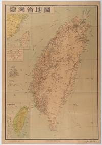
[TAIWAN PROVINCE MAP].
台灣省地圖. Taiwansheng ditu. Map of Taiwan Province.
地圖出版社. Reprint. 1954. Colour folding map of Taiwan showing all major cities towns and villages railways highways roads rivers and sea routes. Topographical inset map at lower left Taiwan Straits with mainland coast inset map at top left. Each map has its own scale. Text in traditional Chinese characters. Washi repairs along some folds on reverse pin marks at corners evenly browned and a little faded. A nice map of Taiwan in fair condition. 77 x 53.8cm. . 地圖出版社. unknown
Référence libraire : 215869
|
|
|
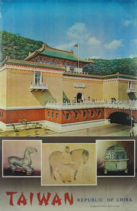
[TAIWAN TRAVEL POSTER].
Taiwan. Republic of China.
Taiwan Visitors Association. No date. Circa1975. Colour photographic travel poster for Taiwan measures Small pin holes at corners and on upper and lower margins a little minor wear and creasing along edges and at corners. Stamp of Australian travel agent Lance Lloyd World Travel Deniliquin NSW lower right corner. 90 x 59.4cm. . Taiwan Visitors Association. unknown
Référence libraire : 143942
|
|
|
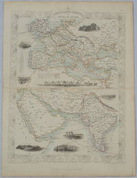
[TALLIS, JOHN], RAPKIN, J., WARREN H., AND KERNOT JH. J. H.
Overland Route to India and China
London.: The London Printing and Publishing Company. circa1850s. Lithographed map with original outline hand colour 33 x 24.5 cm including border and captions seven vignette illustrations two reference keys decorative border central fold light toning mainly at the central fold and to the verso of the sheet in very good condition preserved in a window mount. Attractive decorative map with fine vignettes of the London Post Office Suez Bombay Madras. Aden Malta Gibraltar and a wonderful camel train led by a carriage and horses crossing North Africa originally by the great mapmaker and publisher John Tallis. The two reference keys note steam packet routes railways electric telegraph and the Suez Canal. . The London Printing and Publishing Company. unknown
Référence libraire : 177525
|
|
|
[TERRE SAINTE] - [Cahiers Charles de Foucauld]
Cahiers Charles de Foucauld, n°34, 2e trimestre 1954. En TERRE SAINTE.
1951 Paris, 1954, in 8° broché, 192 pages ; illustrations in et hors-texte ; couverture illustrée.
Référence libraire : 87756
|
|
|
[TERRE SAINTE] - CHAMPDOR (Albert).-
Le Mont Sinaï et le monastère Sainte Catherine.
Paris, Guillot, in 4° cartonnage de l'éditeur, 101 pages.
Référence libraire : 47392
|
|
|
[TERRE SAINTE] - HAVARD (Le P.).-
Le premier pélérinage de pénitence et la Terre Sainte.
Tours, Mame, 1888, in 4° broché, 352 pages ; couverture défraichie et réparée au scotch ; des rousseurs.
Référence libraire : 47398
|
|
|
[TEILHARD DE CHARDIN Pierre] ARAGONNES Claude (recueillies et présentées par).
Lettres de voyage 1923-1955.
Paris, Grasset, 1961, broché, couverture illustrée, 14x19 cm, 368 pages, illustrations noir et blanc.
Référence libraire : 4523
|
|
|
[Telfair, Charles].
An Account of the Conquest of the Island of Bourbon. London, Thomas Egerton (back of title-page and colophon: G. Hayden), 1811.
8vo. (6), 116 pp. With a folding lithographed plan of Saint-Denis. Contemporary dark green cloth, rebacked with the original backstrip laid down. Rare first and only edition of a firsthand account of the British invasion of the Island of Bourbon (Réunion) in 1810 by "an officer of the expedition", sometimes ascribed to Charles Telfair (1778-1833), an Irish botanist who visited Réunion and Mauritius in 1810 as a ship's surgeon to the Royal Navy. The author briefly narrates the events leading up to the invasion, and in more detail describes the invasion itself, providing much information on the ships, squadrons, regiments and officers involved. "His object was to commemorate facts, while he was a spectator of them, and to stamp them with the sentiments they excited" (p. [5]). Also included are the general instructions and directions to officers at the head of brigades, issued by Lt. Col. Keating (pp. 38-53), and transcripts of letters, decrees and newspaper articles (or extracts thereof) relating to the invasion (pp. 54-102). The book closes with an appendix on the island's "value" as a colony, observing its population, climate, agriculture, trade, and infrastructure (pp. 103-116). The island of Bourbon in the Indian Ocean had been in French hands since 1715, until the British Royal Navy invaded it in 1810. The main objective of the expedition, led by Josias Rowley (1765-1842), was to capture the island as well as Mauritius so as "to secure, on the most permanent foundation, the dominion of England against the hostile attempts of France" (p. 4); the French retreated to the islands after raiding British convoys from India. Though the British kept hold of Mauritius, the island of Bourbon was returned to France at the Congress of Vienna of 1814. It was renamed "Réunion" when the house of Bourbon abdicated during the French Revolution of 1848. - Browned and foxed throughout, otherwise in good condition. Binding rebacked and restored. J. McAleer, Britain's Maritime Empire (2016), p. 87.
|
|
|
[Texas - Galveston].
Souvenir of Galveston, Texas. 70 views. Columbus, Ohio, Ward Brothers, published for Victor Phillips, Galveston, 1888.
Small oblong 8vo (150 x 124 mm). Concertina-folded booklet, 18 pp. with a total of 73 photolithographed views, captioned throughout. Publisher's blindstamped original cloth with giltstamped title to upper cover. Pretty series of views of old Galveston before the disastrous hurricane that devastated the city in 1900. During the 19th century, Galveston had become a major commercial centre and one of the largest ports in the US. For a time the largest city in Texas, it was hailed as the "Queen City of the Gulf". - Binding a little rubbed, otherwise fine.
|
|
|
[Textiles.] Nanbenya Jûzô.
Nanbenya Jûzô: Komon cho [Collection of fine patterns]. Japan, Edo period (first half of 18th century).
Large 4to (193 × 287 mm). "Komon" patterns for cloth or paper designs. 13 ff. with 159 (but: 156) katazome-dyed paper pattern sheets numbered and captioned by hand. Japanese block stitching in indigo wrappers and ms. cover label. The inside front cover has a ms. note providing the name and address of the seller or manufacturer: "Minato Onochô itchôme - Nanbenya Jûzô". The borders of the specimen sheets are fashioned by re-using an older manuscript. - "Komon" is a Japanese pattern dye style based on especially minutely patterned all-over designs. The intricacy of this style originated in 16th century Japan, when it served to decorate the "kami-shimo", or official Samurai garments, and the clothes of the Shogun's family and of some Daimyos. Occasionally, these would even have privileged ("forbidden") designs (so-called "tomegara") which nobody else could wear. Until well into the 19th century, the production of and trade in such "komon" patterns was subject to a special monitoring system. Since the end of the 18th century the patterns were increasingly used by the urban population. Due to the extreme costliness of their manufacture, such garments were worn mainly on semi-official occasions, especially for private ceremonies and celebrations. The patterns, distinguished by their superior delicacy and minute detail, are produced with the help of wax paste and paper stencils ("kata-gami-zome" or "katazome"; cf. Klein-Bednay, Japanische Musterbücher des 18. und 19. Jhs., in: Von Morris bis Memphis, p. 359). - Compared with five similar pattern books in the Metropolitan Museum of Art, dated "ca. 1680" and "ca. 1700", the present specimen shows a wider range of basic colours, while some designs are slightly less intricate. In all other respects, however - such as the arrangement of the pages, the materials use, the size and the scope - show evident parallels, while the 19th century katazome pattern books or other 19th century textile design collections differ markedly. - Binding rubbed; lower wrapper and 3 leaves show slight worming near the gutter. Cf. Metropolitan Museum of Art - Digital Collections, Identifier nos. 23.88.5 through 23.88.8 and 23.88.10.
|
|
|
[THIERY (L. V.)].-
GUIDE des AMATEURS et des ETRANGERS VOYAGEURS dans les Maisons royales, Châteaux, lieux de plaisance, établissemens publics, villages et séjours les plus renommés aux ENVIRONS de PARIS. Avec une indication des beautés de la nature et de l'art qui peuvent mériter l'attention des curieux.
1788 Paris, Hardouin et Gattey, 1788, 2 tomes réunies en un volume in 12, relié pleine basane ancienne, dos à nerfs orné, étiquette rouge, 3 feuillets non chiffrés - 504 pages en pagination continue (quelques erreurs de pagination) et XVIII pages - 3 feuillets non chiffrés (dont un feuillet d'errata) ; un carton volant remplaçant les pages 177/178, petite déchirure marginale pages 247/248 (amputant quelques mots) ; frottis d'usage, coiffe supérieure usée, coins émoussés.
Référence libraire : 84129

|
|
|
[THAILLANDE]
La thaillande.
Paris, Librairie larousse, 1988 ; in-4, 159 pp., cartonnage de l'éditeur.
Référence libraire : 201107634
|
|
|
[THAILANDE]
Le grand guide de thailande.
Paris, Gallimard, 1988 ; in-8, 341 pp., br.
Référence libraire : 201307739
|
|
|
[THIBET] SAVAGE LANDOR A.H.
VOYAGE D'UN ANGLAIS AUX REGIONS INTERDITES .
Pays sacré des lamas . Paris ,Hachette ,1899 . In 8° relié 1/2 chagrin rouge à coins .Dos à nerfs .Tête dorée .252 pp.Illustrations en noir in et H.T.(Léger frottis à la coiffe sup.)
Référence libraire : 28196

|
|
|
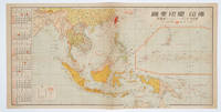
[THE ASAHI SHIMBUN]. 朝日新聞社.
佛印・蘭印要圖. 朝日カレンダー・ニユース地圖版. Futsu-In Ran-In Yozu. Asahi Karenda Nyusu Chizuban. Detailed Map of Southeast Asia. Daily Calendar News Version.
No place of publication.: 朝日新聞社. The Asahi Shimbun. 昭和十五1940. Published by 朝日新聞社 The Asahi Shimbun Japanese folding coloured WWII map with a calendar from January to June Shōwa 15 at the left scale 1:300000. Map includes French Indochina Dutch East Indies and parts of the territory of Papua China and British India. Some light browning and foxing otherwise very good. Text in Japanese. 25.3 x 51cm. Legend at lower left lists the boundaries between continents countries and provincials or regions railways airline routes capitals and Japanese embassies and consulates. <br> <br>The natural resources are indicated across the map. The map also shows parts of the territory of Papua under Australia's administration " 濠洲委任統治領 Gōshū inin tōchiryō". . 朝日新聞社. [The Asahi Shimbun]. unknown
Référence libraire : 160545
|
|
|
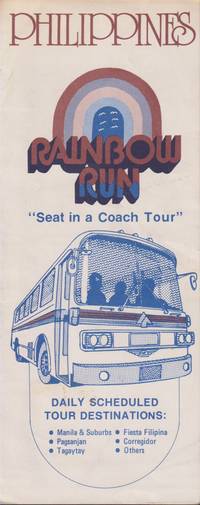
[The Baron Travel Corporation]
PHILIPPINES. RAINBOW RUN Seat in a Coach Tour
Manila: The Baron Travel Corporation. Very Good. Softcover. A travel brochure with description of daily coach tours to Pagsanjan Manila & Suburbs Tagaytay City/Tagaytay Corregidor and Fiesta Filipina. Nd. 1979 ; Oblong 8vo 8" to 9" tall . The Baron Travel Corporation paperback
Référence libraire : 21584
|
|
|
[The Board Of Travel and Tourist Industry and The Philippine Tourist and Travel Association, Inc. ]
PHILIPPINES TOUR GUIDE An Easy Way to See the Philippines
Manila: Travel Association Inc. Very Good. Softcover. Detailed information about 9 multi day trips and a small scematic map in color. Nd. 1950's ; Narrow 8vo 8" to 9" tall . Travel Association, Inc. paperback
Référence libraire : 21607

|
|
|
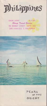
[The Board Of Travel and Tourist Industry and The Philippine Tourist and Travel Association, Inc. ]
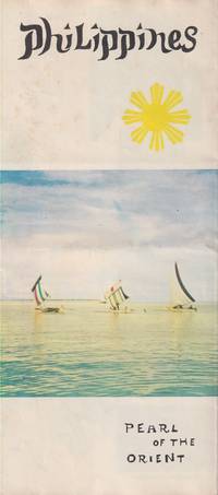
PHILIPPINES Pearl of the Orient
Manila: Travel Association. Very Good-. Softcover. Brochure front stamped. With light edgewear. ; A folded travel brochure with a scematic map of the Philippines. List of towns worth seeing including Manila Baguio Zamboanga Banaue Vigan Iloilo Cebu Bacolod Tagaytay Legazpi Corregidor. Also listing the major celebrations throughout the year. Nd. 1950's ; Oblong 8vo 8" to 9" tall . Travel Association paperback
Référence libraire : 21605
|
|
|
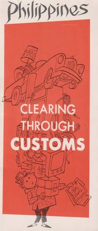
[The Board Of Travel and Tourist Industry and The Philippine Tourist and Travel Association, Inc. ]
PHILIPPINES Clearing through Customs
Manila: Travel Association. Very Good. Softcover. A 20-page booklet with instructions how to go through customs. Including numerous line-drawings in color. A rear customs listing and duties index indicates outragesly high rates. Nd. 1960's ; Oblong 8vo 8" to 9" tall; 20 pages . Travel Association paperback
Référence libraire : 21597
|
|
|
[The Board Of Travel and Tourist Industry and The Philippine Tourist and Travel Association, Inc. ]
PHILIPPINES Pearl of the Orient
Manila: Travel Association. Very Good-. Softcover. Light wear and the slightest hint of foxing to the brochure ; A folded travel brochure with a scematic map of the Philippines. List of towns worth seeing including Manila Baguio Zamboanga Banaue Vigan Iloilo Cebu Bacolod Tagaytay Legazpi Corregidor. Also listing the major celebrations throughout the year. Nd. 1950's ; Oblong 8vo 8" to 9" tall . Travel Association paperback
Référence libraire : 21598
|
|
|
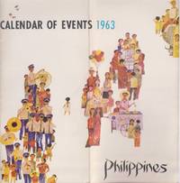
[The Philippine Tourist and Travel Association and The Board Of Travel and Tourist Industry]
PHILIPPINES. CALENDAR OF EVENTS 1963
Manila: Tourist Industry. Very Good. 1963. Softcover. A booklet with numerous photographic fold-outs. Chronological detailed list of events of the year. ; Narrow 8vo 8" to 9" tall . Tourist Industry paperback
Référence libraire : 21593
|
|
|
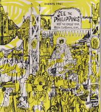
[The Philippine Tourist and Travel Association and The Board Of Travel and Tourist Industry]
SEE THE PHILIPPINES Visit the Orient Year. Rizal Centennial Year. Events 1961
Manila: Tourist Industry. Very Good. 1961. Softcover. A folded booklet with many events listed for the whole year. Including numerous b&w photographs. ; Narrow 8vo 8" to 9" tall; 20 pages . Tourist Industry paperback
Référence libraire : 21590
|
|
|
[The Philippine Tourist and Travel Association and The Board Of Travel and Tourist Industry]
SEE THE PHILIPPINES Year Round Wonderland of Adventure
Manila: Tourist Industry. Very Good. Hardcover. A large fold-out promoting the destination with many color photos and a detailed map in bold colors. Nd. 1950's ; Narrow 8vo 8" to 9" tall . Tourist Industry hardcover
Référence libraire : 21365

|
|
|
[TOUR DU MONDE] - CHARTON (Edouard m) -
Le tour du monde nouveau journal des voyages 1879 premier semestre.
Paris, Librairie hachette et cie, 1879 ; in-4, 430 pp., cartonnage de l'éditeur. 1879 premier semestre reliure frotté.
Référence libraire : 201209571
|
|
|
[TOUR DU MONDE, VOYAGES] - CHARTON (Edouard) -
Le tour du monde - nouveau journal des voyages 1875 deuxième semestre.
Paris, Librairie Hachette et Cie, 1875 ; in-4, 435 pp., pleine percaline rouge dorure a froid muette titre en doré, coiffe du haut manquante mors coté droit du haut un peu fendu sur 3 cm sinon état correct . État correct - qlqs rousseurs usuel- texte bon état - tome XXX.
Référence libraire : 201102601
|
|
 Recevoir par e-mail
 Télécharger en PDF
 Flux RSS


