|
( Littérature en Anglais - Littérature dédicacée ) - Barry Gifford.
Beautiful Phantoms, Selected Poems 1968 - 1980. ( Dédicacé par Barry Gifford + carte postale avec superbe dédicace par Barry Gifford ).
Etats-Unis, California, Editions Tombouctou / Bolinas 1981. In-8 broché de 80 pages au format 14 x 21,5 cm. Couverture illustrée. Dos carré. Plats et intérieur frais malgré d'infimes frottis aux coins et au 1er plat. Edition originale, ornée d'une belle dédicace autographe, signée, et datée de l'auteur. L'exemplaire est enrichi d'une superbe dédicace autographe, signée, de l'auteur en Anglais de 10 lignes sur une carte postale, au format 9,5 x 15 cm, avec un idéogramme Chinois en couverture. Rare ensemble.
Referentie van de boekhandelaar : 8190

|
|
|
( Musique ) - Juliette Gréco - Irmeli Jung - Robert Doisneau.
Programme Juliette Gréco à l'Olympia 1991. ( Avec cordiale dédicace de Juliette Gréco ).
Olympia / Phonogram 1990. In-4 agrafé, non paginé, d'environ 24 pages au format 32 x 24 cm. Couvertures illustrées par des photographies. Plats et intérieur frais malgré de petits tassements aux coins. Magnifique et luxueux programme des spectacle de Juliette Gréco, donnés à l'Olympia en 1991. Très nombreuses photographies en noir de Juliette Gréco, par différents photographes, dont Irmeli Jung et Robert Doisneau. Documents et facsimilés reproduits. Rare édition originale en superbe état général. Précieux exemplaire avec cordiale dédicace de Juliette Gréco en haut de la couverture. Collection personnelle.
Referentie van de boekhandelaar : 32667

|
|
|
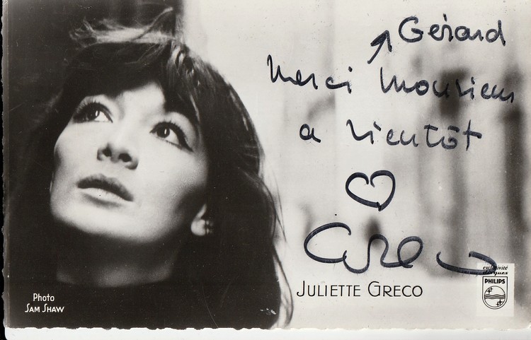
( Musique ) - Juliette Gréco - Sam Shaw.
Carte postale dédicacée par Juliette Gréco
Superbe carte postale Philips en noir et blanc de Juliette Gréco, prise en photo Sam Shaw, au format 8,7 x 14. Au verso liste des enregistrements de l'artiste. Carte enrichie d'une belle dédicace autographe de l'artiste signée par l'artiste.
Referentie van de boekhandelaar : 11058
|
|
|
( Musique ) - Richard Anthony
Carte postale dédicacée par Richard Anthony.
Carte postale Columbia n° 1090 sans date en couleurs de Richard Anthony au format 10,5 x 15 cm. Carte dédicacée par l'artiste au verso. Petit bouts de papier collé au verso. La carte devait être collée dans un album.
Referentie van de boekhandelaar : 13648

|
|
|
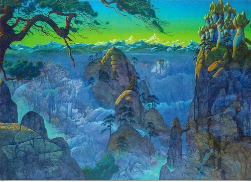
( Musique - Beaux-Arts ) - Roger Dean.
Cartes postale, illustrée par Roger Dean pour le dernier album du groupe de rock progressif " Yes ".
Inside Out éditeur 2021. Carte postale, au format 10,5 x 15 cm, illustrée par Roger Dean pour le dernier album du groupe de rock progressif " Yes ".. Etat de neuf.
Referentie van de boekhandelaar : 27976
|
|
|
( Musique - Cartes Postales ) - André Raimbourg dit Bourvil.
Photographie de Mainbourg, au format carte postale, représentant André Raimbourg dit Bourvil, avec belle dédicace de ce dernier.
Carte Postale Disques Pathé, sans date, ( années 60 ), avec photographie de Mainbourg, représentant André Raimbourg dit Bourvil. Discographie au verso. Belle photographie en superbe état, avec belle et rare dédicace de André Raimbourg dit Bourvil.
Referentie van de boekhandelaar : 30422

|
|
|
( Musique - Cartes Postales ) - Colette Renard.
Photographie argentique de André Nisak, au format carte postale, représentant Colette Renard, avec belle dédicace de cette dernière.
Photographie argentique noir et blanc de André Nisak, au format carte postale, 14 x 9 cm, sans date ( années 50 ), représentant Colette Renard. Belle photographie en superbe état, avec rare et belle dédicace de Colette Renard.
Referentie van de boekhandelaar : 30423

|
|
|
( Musique - Cartes Postales ) - Marie Bizet.
Photographie argentique du Studio Star, au format carte postale, représentant Marie Bizet buvant un verre de Saint Raphaël, avec belle dédicace de cette dernière.
Photographie argentique noir et blanc, du Studio Star, au format carte postale, 13,5 x 9 cm, sans date ( années 50 ), représentant Marie Bizet buvant un verre de Saint Raphaël. Belle photographie en superbe état, avec belle dédicace de Marie Bizet.
Referentie van de boekhandelaar : 30430

|
|
|
( Musique - Cartes Postales ) - Maurice Baquet.
Photographie argentique du Studio Star, au format carte postale, représentant Maurice Baquet jouant du violoncelle, avec belle dédicace de ce dernier.
Photographie argentique noir et blanc, du Studio Star, au format carte postale, 14 x 9 cm, sans date ( années 50 ), représentant Maurice Baquet jouant du violoncelle. Belle photographie en superbe état, avec belle dédicace de Maurice Baquet.
Referentie van de boekhandelaar : 30421

|
|
|
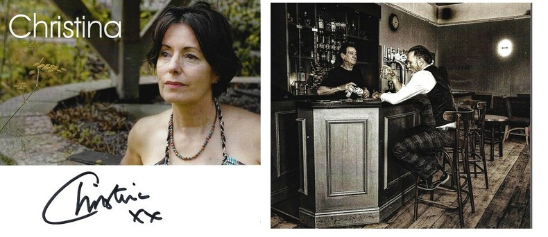
( Musique - Rock ) - Christina Booth.
Carte signée par Christina Booth, chanteuse du groupe de Rock Progressif Magenta.
Editions Tiger Moth 2023. Superbe carte illustrée, au format 14 x 12,5 cm, reprenant la pochette du nouvel album de l'artiste : Bar Stool Prophet, signée au verso par Christina Booth, chanteuse du groupe de Rock Progressif Magenta. Edition originale. Collection personnelle.
Referentie van de boekhandelaar : 29135
|
|
|
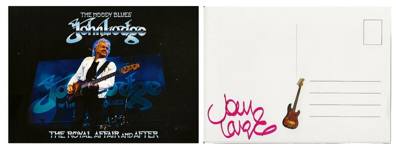
( Musique - Rock ) - John Lodge des Moody Blues.
Carte postale signée par le bassiste et chanteur du groupe " The Moody Blues " : John Lodge.
Editions Keeping the Faith 2021. Superbe carte postale au format 10,5 x 15 cm, signée au verso par John Lodge, bassiste et chanteur, notamment du groupe The Moody Blues. Edition originale. Collection personnelle.
Referentie van de boekhandelaar : 28029
|
|
|
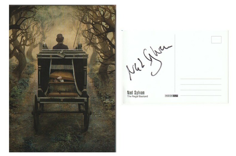
( Musique - Rock ) - Nad Sylvan.
Carte postale signée par le chanteur Nad Sylvan.
Editions Inside Out, sans date ( 2021 ). Superbe carte postale illustrée, au format 10,5 x 15 cm, signée au verso par Nad Sylvan, chanteur ( entre autres ) du groupe de Steve Hackett et assurant au sein de celui-ci les titres chantés auparavant, par Peter Gabriel. Edition originale. Collection personnelle.
Referentie van de boekhandelaar : 10203
|
|
|
( Paul Eluard ) - Luc Decaunes - Léon-Gabriel Gros - Jean-Claude Laurens.
Paul Eluard + lettre autographe + carte postale.
Editions Subervie 1965. In-8 broché de 160 pages au format 14,2 x 19,2 cm. Biographie suivie de notes et d'un essai de bibliographie des oeuvres publiées en langue Française. Photos et documents hors texte. Edition originale non coupée en état proche du neuf. Précieux exemplaire ayant appartenu à l'auteur. Il est joint une lettre manuscrite de 2 pages, sous enveloppe d'un de ses amis : Jean-Claude Laurens. Ce dernier était chargé de récuperer chez l'éditeur Jean Subervie des exemplaires du livre, afin de les expédier à Luc Decaunes, qui n'en possédait aucun exemplaire ainsi q'une carte postale des éditions " Les Cahiers du Sud " datée du 12 mai 1945, affranchie et cachetée. Au verso on trouve un très long texte affectueux de 30 lignes signé par Léon-Gabriel Gros, adressé à Luc Decaunes.
Referentie van de boekhandelaar : 2066

|
|
|
( PORT-LOUIS - MORBIHAN - BRETAGNE )
1 plan ancien gravé sur cuivre, et finement colorié à l'époque : LE PORT-LOUIS ( Morbihan, Bretagne )
1 plan ancien (début XIXe?) gravé sur cuivre, et finement colorié à l'époque : Le Port-Louis ( Morbihan, Bretagne ). Plan de la ville, de ses fortifications et de sa citadelle. Feuille de format : 17,5 x 24 cm. Plan gravé sur cuivre, imprimé sur papier vergé fort, et finement aquarellée à l'époque (original hand coloring). Bel exemplaire ( Photographies sur demande / We can send pictures of this print on simple request )
Referentie van de boekhandelaar : 51025
|
|
|
( Publicité Dentifrice Gibbs ) - Pierre et Pierrette.
Carte postale publicitaire, dédicacée, par Pierre et Pierrette pour le dentifrice Gibbs.
Superbe carte postale publicitaire pour le Dentifrice Gibbs, en noir et blanc, au format 14 x 8,7. Carte dédicacée par Pierre et Pierrette. Comme neuf.
Referentie van de boekhandelaar : 27904

|
|
|
( VILLEFRANCHE / LA CIOTAT )
1 plan ancien gravé sur cuivre, et finement colorié à l'époque, figurant : 1°/ VILLEFRANCHE (Villefranche-sur-Mer, plan de la ville et de sa citadelle). 2°/ LA CIOTAT (plan de la ville, et de ses fortifications)
1 plan ancien (début XIXe?) gravé sur cuivre, et finement colorié à l'époque, figurant : 1°/ VILLEFRANCHE (Villefranche-sur-Mer, plan de la ville et de sa citadelle, près de Nice, Alpes-Maritimes, Provence). 2°/ LA CIOTAT (plan de la ville, et de ses fortifications). Feuille de format : 18 x 25 cm. Plan gravé sur cuivre, imprimé sur papier vergé fort, et finement aquarellée à l'époque (original hand coloring). Bel exemplaire ( Photographies sur demande / We can send pictures of this print on simple request )
Referentie van de boekhandelaar : 51026
|
|
|
( VILLEFRANCHE / LA CIOTAT )
1 plan ancien gravé sur cuivre, figurant : 1°/ VILLEFRANCHE (Villefranche-sur-Mer, plan de la ville et de sa citadelle). 2°/ LA CIOTAT (plan de la ville, et de ses fortifications)
1 plan ancien (début XIXe?) gravé sur cuivre, figurant : 1°/ VILLEFRANCHE (Villefranche-sur-Mer, plan de la ville et de sa citadelle, près de Nice, Alpes-Maritimes, Provence). 2°/ LA CIOTAT (plan de la ville, et de ses fortifications). Feuille de format : 18 x 25 cm. Plan gravé sur cuivre, imprimé sur papier vergé fort. Bel exemplaire ( Photographies sur demande / We can send pictures of this print on simple request )
Referentie van de boekhandelaar : 51027
|
|
|
(Adler, C.)
Neuester Plan von Hamburg-Altona-Wandsbek und Vororten. Mit ausführlichem Verzeichniss der Strassen & öffentlichen Gebäude.
Hamburg, C. Adler, [ca. 1915]. 24 S. Straßenverzeichnis (mit Sondermarkierungen für A: Altona, W: Wandsbek, O: Ohlsdorf-Fuhlsbüttel und P: Preussisches Gebiet). Mit 1 mehrf. gefalt. farb. lithogr. Plan im Maßstab 1:18.000. Blattgröße 49,5 x 65 cm. Deckel cm. OLn.
Referentie van de boekhandelaar : 39340

|
|
|
(agrandissement d'une carte postale ancienne).
Saint-Etienne-de-Boulogne (Ardèche) - Vue générale.
Macon, Combier (CIM), retirage (années 60) d'une carte postale du début XXème, 1 sous-verre, support cartonné, pinces métalliques, crochet de suspension, dimension tout cadre: 29 x 21 cm (encadrement Reynier, Aubenas). retirage photo de 23 x 15 cm ;
Referentie van de boekhandelaar : 17909
|
|
|
(ALASKA: BOUNDARY SURVEY MAPS)
British Case. Alaska Boundary. Portfolio of Maps Accompanying International Boundary Commission. Appendix. Volume III.
London: McCorquodale 1903. First edition of this atlas map folio 16 1/4 x 27 1/2 inches. 5 sheets of British Commission maps and index map; 13 sheets of United States Commission maps Alaska boundary atlas and index map. Total of 20 maps 19 folding and 5 in color Maps are 53 x 32 inches. All but the British index map folded and backed in linen. Quarter red morocco over red cloth. Gilt Royal Seal to front board and spine. Maps mounted on linen and sectioned as issued. Portfolio case with moderate rubbing chipping to leather. Does not include the 10 cards to accompany the U.S. Commission maps seems to be common that these smaller ones are missing. Old staining to cloth. Toning and edge wear to British Index map. Slight toning and offsetting to maps. Overall a very good copy; quite scarce. [McCorquodale] hardcover
Referentie van de boekhandelaar : 75062
|
|
|
(André Pazdzerski).
Dessin: "Couleur Ardèche" (ferme au toit de genéts au pied du Gerbier de Jonc).
Ucel, chez l'artiste, 1977, 1 carte postale en couleurs de 10 x 15 cm, illustré par le peintre André Pazdzerski, avec un envoi autographe, signé de cet artiste.
Referentie van de boekhandelaar : 18419
|
|
|
(AUTOMOBILE MAPS)
Tour Book of the Automobile Club of America.
New York: Automobile Club of America 1911. First edition Tall octavo. 876 pp. plus 48 leaves of maps one folding. Original flexible calf with two-brad binding gilt cover lettering yellow endpapers. Leather with some professional restoration. Text complete and clean. OCLC only records 3 copies all east of the Mississippi.The very first coast-to-coast automobile guidebook was published in 1901 The Official Automobile Blue Book. One usually finds these early automobile road guides devoted to specific parts of the country New England West Coast etc. but this one covers the entire nation. In this guidebook the routes given for the West comprise the smallest section of the book. 1911 was before the official opening of all of the major early automobiles routes: The Lincoln Highway planned in 1912 officially opened in 1913; The National Old Trails Road 1912; The Yellowstone Trail 1912; Pacific Coast Highway began in 1913. Automobile Club of America hardcover
Referentie van de boekhandelaar : 76478
|
|
|
(CALIFORNIA: MAPS)
A Travel Package from AAA.
Los Angeles: Automobile Club of Southern California ca. 1940. A fine grouping of 14 pre-freeway California maps from the Automobile Club of Southern California. Housed in the original box given to the subscriber when he received them at his local office one end missing but attractive nonetheless. A few slight separation fold splits but overall in very good condition with the majority appearing to have never been opened.Maps are; Eastern Section of Los Angeles; Central Section of Los Angeles; Southern Section of Los Angeles; San Fernando Valley Section of Los Angeles; Orange County; Metropolitan Los Angeles; Imperial County; San Diego County; Kern County; San Luis Obispo County; Tulare County; Ventura County; Riverside County; California. Automobile Club of Southern California unknown
Referentie van de boekhandelaar : 71435
|
|
|
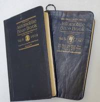
(CALIFORNIA: MAPS)
Official Automobile Blue Book. Volume Eight 1919; California Nevada Utah and Arizona with extension routes into Oregon Colorado Idaho Wyoming and Montana. With Volume Nine 1921; Alberta British Columbia Idaho Manitoba Montana Nebraska North Dakota Oregon Utah Northern Washington and Wyoming.
Chicago: Automobile Blue Book Publishing 1919 & 1921. Vol. 8; Tall octavo. 776 pp. including numerous inserts maps photographic illustrations. Complete. Publisher's flexible blue cloth with gilt cover lettering. Expertly rebacked retaining the original spine. Ver good.Vol. 9; Tall octavo. 848 pp. including numerous inserts maps photographic illustrations. Complete but for the folding map at the rear often missing as they were used. The map is reproduced in smaller segments on pp. 2-21. Publisher's flexible blue cloth with gilt spine and cover lettering. Some creases and general rubbing but a good complete copy.Between these two books the entire West Coast is covered. Between them they detail 1783 driving routes across the arid west. These are exhaustive and comprehensive guides to early car touring in California and the West. With such instructions as 'turn left after the wooden bridge" we can infer that car travel in 1920 was a difficult proposition at best. There is an illustrated chapter on Yosemite with a full page map and five pages of texts with illustrations. While "Official Automobile Blue Books" are not rare one usually finds the guides for New York or the Midwest with Vol. 8 California and Vol. 9 Oregon and Washington rarely appearing on the market. Chances are that these particular volumes were just generally used to oblivion as California has always been the most car-friendly state in the Union and the Pacific Northwest was by and large empty of people. Automobile Blue Book Publishing hardcover
Referentie van de boekhandelaar : 74907
|
|
|
(carnet de cartes postales détachables).
CHÂTEAU DE MONTROTTIER.
Annecy, Académie Florimontane, s.d. (vers 1920), 1 broché. Carnet oblong de 10 cartes postales bistres (sur 12 annoncées) de 14 x 9 cm ;
Referentie van de boekhandelaar : 18076
|
|
|
(Carnet de cartes postales détachables).
EXPOSITION COLONIALE. Marseille 1922.
s.l., s.n., 1922, 1 agraphé, sans couverture. Carnet oblong de 20 cartes postales détachables de 16 cm x 9 cm, légére mouillure sur la dernière carte postale ;
Referentie van de boekhandelaar : 19082
|
|
|
(carte postale).
Château de Ventadour.
Meyras, Association de Sauvgarde du château-fort de Ventadour, s.d. (années 70), 1 carte postale en couleurs de 15 x 11 cm, vue aérienne, face est.
Referentie van de boekhandelaar : 18516
|
|
|
(carte postale).
Château de Ventadour.
Meyras, Association de Sauvgarde du château-fort de Ventadour, s.d. (années 70), 1 carte postale en couleurs de 15 x 11 cm, vue aérienne, face nord.
Referentie van de boekhandelaar : 18517
|
|
|
(carte postale).
Château de Ventadour.
Meyras, Association de Sauvgarde du château-fort de Ventadour, s.d. (années 70), 1 carte postale en couleurs de 15 x 11 cm, vue de l'intérieur du château.
Referentie van de boekhandelaar : 18960
|
|
|
(carte postale).
Château de Ventadour.
Meyras, Association de Sauvgarde du château-fort de Ventadour, s.d. (années 70), 1 carte postale en couleurs de 15 x 11 cm, vue de la face ouest.
Referentie van de boekhandelaar : 18961
|
|
|
(Carte postale).
LE CHATEAU DE BOULOGNE au XVe siècle (propriété du marquis de Lestrange).D'aprés un dessin de Gagne (vue générale du château , prise en vue aérienne).
Saint-Etienne de Boulogne, cliché Prinsac, collection "l'Ardèche Pittoresque", s.d. (vers 1910), 1 carte postale de 14 x 9cm, 2 petites taches de rousseurs ;
Referentie van de boekhandelaar : 17271
|
|
|
(Carte postale).
Portrait photo de l'abbé Prat, curé à St-Thomé (Ardèche).
Tournon, photo J. Taffala, s.d. (vers 1942), 1 Carte postale de 9 x 14 cm, texte autographe, signé de l'abbé A. Prat au verso.
Referentie van de boekhandelaar : 17845
|
|
|
(Cartes Larousse).
Cartes Larousse: Atlas de la Guerre. With Directions in English I-XLI COMPLETE 41 ISSUES WITH 206 PLATES.
Paris Librairie Larousse 1915-19. 1st Edition . Hardcover. . ~ ~ NOTE: THE PRICE OF THIS BOOK IS CURRENTLY REDUCED! ~ ~ . 41 issues bound in one volume. Thick royal quarto. Unpaginated. With hundreds of letterpress maps many of which are in colour printed on recto only on 246 leaves of plates. Some photo-plates. Explanatory text to each map. Introductions. HARDCOVER bound in handsome brown quarter morocco bit rubbed and scuffed in places spine with raised bands gilt lettering to second compartment gilt fleuron to each of the others vellum French corners marbled endpapers with original yellow card wrapper of first issue bound-in. In about fine condition. Excellent copy. ~ FIRST EDITION. Very rare. G-3 <br/> <br/> Paris, Librairie Larousse, (1915-19). hardcover
Referentie van de boekhandelaar : 5178
|
|
|
(Cartes Larousse).
Cartes Larousse: Atlas de la Guerre. With Directions in English I-XLI 41 ISSUES WITH 206 PLATES. COMPLETE.
Paris Librairie Larousse 1915-19. 1st Edition . Hardcover. . ~ ~ NOTE: THE PRICE OF THIS BOOK IS CURRENTLY REDUCED! ~ ~ . 41 issues bound in one volume. Thick royal quarto. Unpaginated. With hundreds of letterpress maps many of which are in colour printed on recto only on 246 leaves of plates. Some photo-plates. Explanatory text to each map. Introductions. HARDCOVER bound in contemporary quarter cloth bit rubbed and scuffed in places paper-covered boards cloth inner hinges spine gilt. All 41 original yellow card wrappers printed in red are preserved and bound-in few with old institutional stamp; expert paper repair to one leaf with minor loss. In about fine condition. Excellent copy very well preserved. ~ FIRST EDITION. Very rare. F-3 <br/> <br/> Paris, Librairie Larousse, (1915-19). hardcover
Referentie van de boekhandelaar : 1965

|
|
|
(cartes postales).
Porcelain from Jingdezhen.
Chine, XXème, 1 sous pochette illustrée, texte en chinois et en anglais à l'intérieur de la pochette. 11 cartes postales en couleurs de 10 x 15 cm ;
Referentie van de boekhandelaar : 17960
|
|
|
(cartes à jouer)
DOMINOS-CARTES
1857 Jeu de dominos-cartes célébrant l'histoire du Premier et du Second Empire jusqu'à la fin de la Guerre de Crimée.Paris (?) : Krum & Cie, vers 1857, chromolithographie avec passage d'or, 28 cartes (complet) 79 x 56 mm, figures doubles variables, coins carrés dos rose.
Referentie van de boekhandelaar : 103363

|
|
|
(cartes à jouer)
Jeu «Alla Russa»
Florence, après 1840, portrait florentin III, 52/52 coins carrés blason survalet de trèfle (Léopold II Habsbourg) lithographie, pochoir coloris manuels.Filigrane fleur de lys (lys de Florence) sur toutes les cartes.Chiari (?) vers 1840-1850, (taxe13,4) tampon sur valet de pique 1840.Non signalé par Sylvia Mann (proche de 202)(103364)
Referentie van de boekhandelaar : 103364

|
|
|
(Compiler), Benchmark Maps
Washington Road & Recreation Atlas Benchmark Maps
US: National Geographic Maps 2015. National Geographic Maps 2015 5th Edition Very Good/ Bright glossy cover with light scratching and light corner creasing to bottom front corner. Printed in 2011. Color maps. 127 pages. OVERSIZE HEAVY ITEM 1.25 Pounds. Size: 15 3/8 x 10 3/4 x 1/4 inches. 5th Edition. Paperback. Very Good. No Exp. National Geographic Maps Paperback
Referentie van de boekhandelaar : 362557 ISBN : 0929591984 9780929591988

|
|
|
(DELSKAMP, F.W.) / DAUCH, J. Ph. 2 Tafeln gestochen von (gravé par):
1) Le Mont Blanc, la vallée de Chamouny, Col de Balme, Col de la Seigne et la route du grand St. Bernard.2) Partie de la Savoie du Lac d’Annecy , Lac de Bourget, et des Environs de Chambery. (2 Cartes a vol d’oiseau / Vogelschaukarten).
s.d., um 1856. 35 x 57 cm ( la feuille), Cartes gravés tirées de l’Atlas de F.W. Delskamp / J. Ph. Dauch sc.: Malerisches Relief der Schweizer und angrenzenden Alpen. Nach der Natur aufgenommen. Frankfurt a. M., 2 planches.
Referentie van de boekhandelaar : 137054aaf
|
|
|
(Düwel, Robert)
Hamburg und seine schöne Umgebung. (Faltplan. Hrsg. von der Fremdenverkehrs- u. Kongress-Zentrale Hamburg e.V.).
(Hamburg, gedr. bei Gebr. Sülter, 1966). 1 mehrfach gefalt. farb. Ktn.-Skizze, gezeichnet von Heinz Schultchen (ca. 42 x 60 cm), verso Text.
Referentie van de boekhandelaar : 63766

|
|
|
(Galletti, Johann)
Weltkarte. Gestochen von J. N. Champion I. G.
o. O. u. J. (um 1822). Kupferst., altkol., 26 x 36 cm. Kartenbild mit wenigen Braunfl., w. Rand etwas stärker braunfl., einige Gebrauchsspuren, Knickstelle an re. ob. Ecke. Planiglob der östlichen und westlichen Hemisphäre.
Referentie van de boekhandelaar : KART0032

|
|
|
(HOMANN, J.B.).
Rojaumes de Corée et de Iapan.
(Nürnberg, ca. 1730). 51,5x41,5 cm. Engraved map of eastern Asia with part of China and Japan up to Saghalin Island, in original handcolouring. The broad margins a bit browned, orherwise fine.
|
|
|
(HOMANN, J.B.).
Rojaumes de Corée et de Iapan.
(Nürnberg, ca. 1730). 51,5x41,5 cm. Engraved map of eastern Asia with part of China and Japan up to Saghalin Island, in original handcolouring. The broad margins a bit browned, orherwise fine.
Referentie van de boekhandelaar : 27994
|
|
|
(Ireland - maps) Mark Allen
Catholic Ecclesiastical Map of Ireland 1859 and pamphlet KEY to the Catholic Ecclesiastical Map of Ireland
Dublin: Mark Allen 1859. Hardcover. Very Good. Published 1859 the map in 20 panels backed with linen measures 39.75 x 29.5 inches 100.5 x 75 cm hand colored in outline in very good condition small gray spot to blank area lower left in original cloth binding with printed label to front cover light wear and soil to binding. The accompanying pamphlet 31 pp. green wraps very good some of the stitching along spine coming loose. Both map and pamphlet signed Francis L. Casey RCV Cork. Uncommon. Mark Allen hardcover
Referentie van de boekhandelaar : H4454

|
|
|
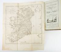
(IRELAND - MAPS). TAYLOR, GEORGE and ANDREW SKINNER
TAYLOR AND SKINNER'S MAPS OF THE ROADS OF IRELAND: SURVEYED IN 1777 AND CORRECTED DOWN TO 1783
London: Engraved by G. Terry and Sold by T. Longman London and W. Wilson Dublin 1783. Second Corrected Edition. 260 x 155 mm. 10 1/4 x 6". XXVII 289 pp. 4 leaves index. <br/> Contemporary half calf over marbled boards flat spine divided into panels by gilt rules red morocco label very neat repair to head of front joint and top of spine. Engraved title page with vignette and dedication leaf large folding map of Ireland and 289 engraved maps. Title page with early ink signature of Jos. Sabine. Moreland & Bannister p. 190; Tooley "Maps and Mapmakers" p. 94. â—†Small signs of age and wear to the binding including slight crackling and nicks to the spine folding map with faint dampstain to tail margin two negligible ink spots to blank area on the map of the Irish Sea but A VERY APPEALING COPY quite clean and remarkably fresh internally and in an entirely solid period binding.<br/> <br/> This is the second corrected edition of the first comprehensive road atlas of Ireland offered here in especially attractive condition. In response to increasing demand for accurate maps of the country's road system the Irish House of Commons commissioned George Taylor and Andrew Skinner who together had previously produced the first road atlas of Scotland among other works to undertake a survey of the land. Taylor and Skinner completed their work in 1777 and published the first edition of their findings in 1778. This second edition includes updates to the year 1783 as well as an additional map no. 289. Renowned for their precision and detail Taylor and Skinner's maps clearly show roads crossroads and bridges as well as topographical features such as hills lakes and rivers including the direction of the water flow; landmarks such as castles churches and ruins; and the names of local landlords and their homes. The maps appear either as half-page strips or in full-page and the distances are given in both Irish and English miles 11 Irish miles being equal to 14 British miles. The robust list of subscribers which includes a number of earls viscounts lords bishops and British and Irish army men demonstrates the great need for and widespread success of this important work. While not a rare book this is the kind of volume that would have normally encountered frequent and inevitably damaging use so to find a copy as well preserved as this one is a lucky occurrence. Engraved by G. Terry and Sold by T. Longman, London and W. Wilson, Dublin unknown
Referentie van de boekhandelaar : ST19355
|
|
|
(Klahn, Peter)
Hamburg: Das Elbufer. Von Altona bis Wittenbergen. (Hrsg. von der Hamburg e.V.).
Hamburg, Fremdenverkehrs- u. Kongreß-Zentrale, 1960]. 12seitiges Faltblatt, mit farb. illustr. von Heinz Eimert (simplifizierter Straßenplan). Blatt 20 x 58 cm. Falzmaß 20 cm.
Referentie van de boekhandelaar : 63173

|
|
|
(LÖWENÖRN, P. (POUL) de). - SHETLAND ISLANDS.
Beretning om et forbedret Kaart over de Hetlandske Öer, tilligemed trende Blade med Landtoninger og et speciel Kaart over Valley-Sund paa Hetland. Udgivet fra det Kongelige Söe-Kaarte-Archiv 1787. (Description of a new improved chart of the Islands of...
Kiöbenhavn, Thiele, 1787. 4to. Originale blåmarmorerede omslag. Stempel på titelbladet. 16 pp., 4 kobberstukne plancher (3 foldede med landtoninger samt et kort). Rent velbevaret eksemplar på skrivepapir.
|
|
|
(LÖWENÖRN, P. (POUL) de). - SHETLAND ISLANDS.
Beretning om et forbedret Kaart over de Hetlandske Öer, tilligemed trende Blade med Landtoninger og et speciel Kaart over Valley-Sund paa Hetland. Udgivet fra det Kongelige Söe-Kaarte-Archiv 1787. (Description of a new improved chart of the Islands of...
Kiöbenhavn, Thiele, 1787. 4to. Originale blåmarmorerede omslag. Stempel på titelbladet. 16 pp., 4 kobberstukne plancher (3 foldede med landtoninger samt et kort). Rent velbevaret eksemplar på skrivepapir.
Referentie van de boekhandelaar : 56969
|
|
|
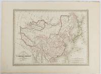
(MALTE-BRUN, CONRAD) THIERRY, ENGRAVERS.
Carte Générale de l'Empire Chinois et du Japon.
Paris. circa1837. Engraved map with original outline hand-colour 22 x 30 cm; 28.8 x 38.6 cm sheet marginal repair to the lower corner not affecting the map sheet lightly age-toned in very good condition preserved in a window mount. Fine map of China Japan and Central Asia noting Manchuria "Mandchourie" bordering Northern India and Turkestan in the West and Russia "Russie d'Asie" in the North. <br> <br>From the estate of the late collector and scholar Arthur Hacker with his pencilled catalogue mark on the verso. . unknown
Referentie van de boekhandelaar : 177519
|
|
|
(MAPS -- USA.) U. S.
Catalog Number 118: America in Maps -- Tracing the Growth and Development of Individual States from 1776 to 1881
Baltimore: Southern Book Co n.y. Paperback. Small 4to. Printed wrappers. 23pp. Very good. Outer wrappers only rather age toned and lightly worn else tight and internally near fine. Intriguing offering of atlas maps from this noted Maryland dealer -- whose slim size belies its 619 entries. A crash course in U.S. atlas maps and at prices that will bring tears to your eyes -- low of $3.00 to high of $15.00. Undated but lacking zip codes thus pre-1963 and most likely of late 1950s vintage. Interestingly the original recipient on outer address panel was CARL HAVERLIN 1899-1985 noted Lincoln and Civil War scholar radio pioneer and president of Broadcast Music Inc. BMI. Southern Book Co paperback
Referentie van de boekhandelaar : 51321
|
|
 De zoekresultaten per email ontvangen
 Zoekresultaten downloaden als PDF
 RSS feed


