|
Ministère des colonies
Cadastre, instructions techniques à l'usage du personnel du service du cadastre de la colonie. Ministère des colonies : Carthographie et cadastre.
Bruxelles, Imprimerie Marcel Hayez, 1949. "16 x 24, 124 pp., 36 figures, broché, bon état (couverture très légèrement insolée; cachet d'ex-propriétaire)."
Bookseller reference : 91158
|
|
|
MINISTÈRE des TRAVAUX PUBLICS.
[BARCELONE] Barcelone.
Paris, Auto. Marchadier et Cie, 1883. 295 x 462 mm.
Bookseller reference : LBW-5473

|
|
|
MINISTÈRE des TRAVAUX PUBLICS.
[BOSTON] Boston.
Paris, Auto. Marchadier et Cie, 1884. 295 x 661 mm.
Bookseller reference : LBW-5432

|
|
|
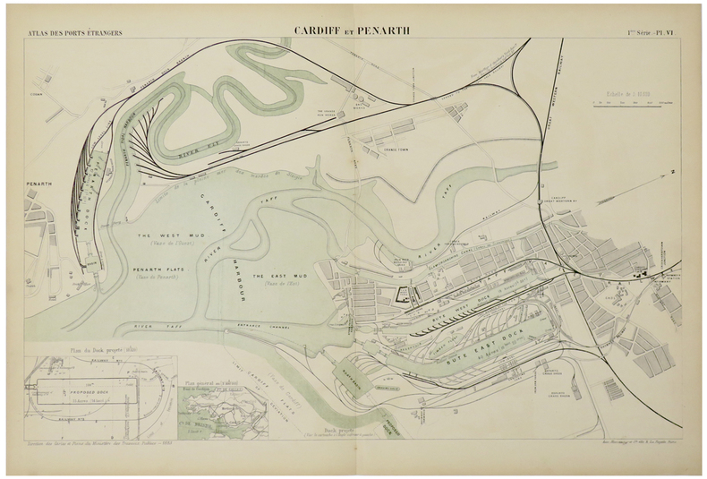
MINISTÈRE des TRAVAUX PUBLICS.
[CARDIFF] Cardiff et Penarth.
Paris, Auto. Marchadier et Cie, 1883. 290 x 462 mm.
Bookseller reference : LBW-5476
|
|
|
MINISTÈRE des TRAVAUX PUBLICS.
[CHARLESTON] Charleston.
Paris, Auto. Marchadier et Cie, 1884. 295 x 472 mm.
Bookseller reference : LBW-5449

|
|
|
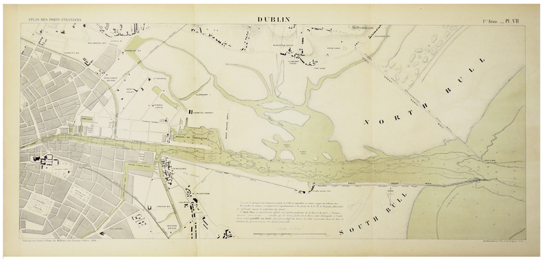
MINISTÈRE des TRAVAUX PUBLICS.
[DUBLIN] Dublin.
Paris, Auto. Marchadier et Cie, 1884. 290 x 651 mm.
Bookseller reference : LBW-5475
|
|
|
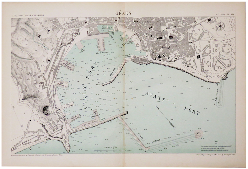
MINISTÈRE des TRAVAUX PUBLICS.
[GÊNES] Gênes.
Paris, Auto. Marchadier et Cie, 1884. 290 x 450 mm.
Bookseller reference : LBW-5472
|
|
|
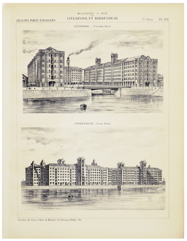
MINISTÈRE des TRAVAUX PUBLICS.
[LIVERPOOL] Magasins à blé de Liverpool et Birkenhead.
Paris, Auto. Marchadier et Cie, 1884. 286 x 209 mm.
Bookseller reference : LBW-5467
|
|
|
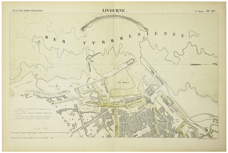
MINISTÈRE des TRAVAUX PUBLICS.
[LIVOURNE] Livourne.
Paris, Auto. Marchadier et Cie, 1884. 285 x 460 mm.
Bookseller reference : LBW-5471
|
|
|
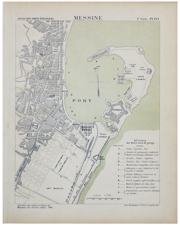
MINISTÈRE des TRAVAUX PUBLICS.
[MESSINE] Messine.
Paris, Auto. Marchadier et Cie, 1884. 285 x 212 mm.
Bookseller reference : LBW-5470
|
|
|
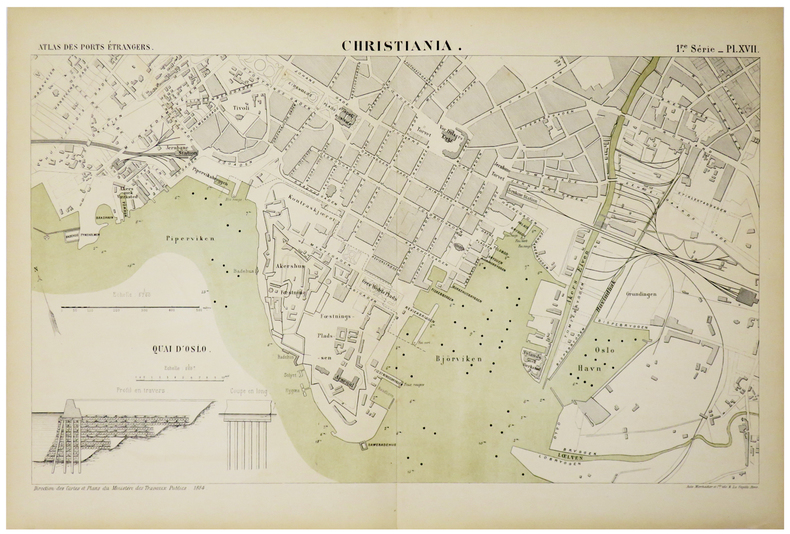
MINISTÈRE des TRAVAUX PUBLICS.
[OSLO] Christiania.
Paris, Auto. Marchadier et Cie, 1884. 285 x 459 mm.
Bookseller reference : LBW-5469
|
|
|
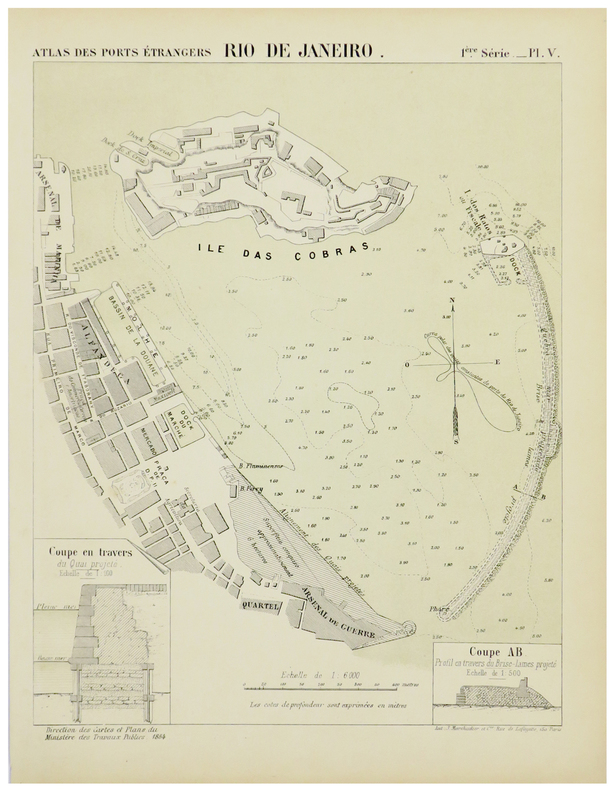
MINISTÈRE des TRAVAUX PUBLICS.
[RIO de JANEIRO] Rio de Janeiro.
Paris, Auto. Marchadier et Cie, 1884. 295 x 225 mm.
Bookseller reference : LBW-5430
|
|
|
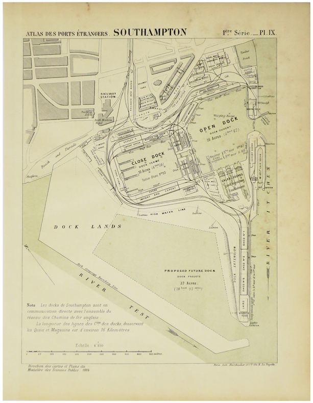
MINISTÈRE des TRAVAUX PUBLICS.
[SOUTHAMPTON] Docks de Southampton.
Paris, Auto. Marchadier et Cie, 1883. 300 x 450 mm.
Bookseller reference : LBW-5466

|
|
|
MINISTÈRE des TRAVAUX PUBLICS.
[SOUTHAMPTON] Southampton.
Paris, Auto. Marchadier et Cie, 1884. 285 x 211 mm.
Bookseller reference : LBW-5474
|
|
|
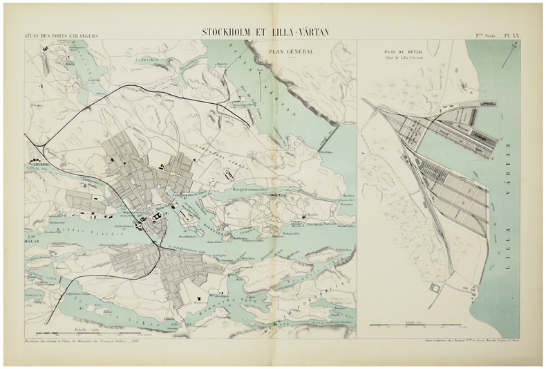
MINISTÈRE des TRAVAUX PUBLICS.
[STOCKHOLM] Stockholm et Lilla-Värtan.
Paris, Auto. Marchadier et Cie, 1883. 285 x 452 mm.
Bookseller reference : LBW-5468
|
|
|
Ministères des affaires étrangères
Documents diplomatiques, accords conclus le 8 avril 1904 entre la France et l'Angleterre au sujet du maroc, de l'Egypte, de Terre-Neuve, etc.
Paris, imprimerie nationale, 1904, in folio : 48 pp. Plaquette
Bookseller reference : 4720
|
|
|
Minnesota Rivers Maps
Snake Upper Red and Minnesota Rivers Minnesota; Reservoirs at Sources of rock River Wisconsin and Illinois
Washington DC: U. S. Congress. Very Good. 1881. Pamphlet. Snake Upper Red and Minnesota Rivers Minnesota; Reservoirs at sources of Rock River Wisconsin and Illinois. Letter from the Secretary of War transmitting surveys .United States. War Department. 1881. 16 pages maps 2 folded ; 23 cm. Washington Govt. Print. Off. 1881. Disbound Pamphlet. The contents are nice and the 2 folding maps are bright and clean. . U. S. Congress unknown books
Bookseller reference : 74181
|
|
|
Miquelon, Dale; Ingram, George C.; Morrison, William R.;
Canadian Historic Sites - Occasional Papers in Archaeology and History No. 4
188 pages. Includes the following papers: A Brief History of Lower Fort Garry; The Big House, Lower Fort Garry; Industrial and Agricultural Activities at Lower Fort Garry; The Sixth Regiment of Foot at Lower Fort Garry; The Second Battalion, Quebec Rifles, at Lower Fort Garry. Includes a variety of black and white illustrations and maps. Unmarked. Moderate wear. Book
|
|
|
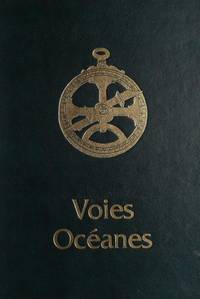
Mireille Pastoureau, Departement des cartes et plans Bibliotheque nationale et Societe de geographie
Voies océanes - de l'ancien aux nouveaux mondes
Hervas 1990. Hardcover. Good. Former library book. Different cover. Edition 1990. Ammareal gives back up to 15% of this item's net price to charity organizations. Hervas hardcover
Bookseller reference : F-804-767 ISBN : 2903118612 9782903118617
|
|
|
Mireille PASTOUREAU
VOIES OCEANES, de l'ANCIEN aux NOUVEAUX MONDES
Un ouvrage de 188 pages, format 220 x 305 mm, illustré, relié cartonnage sous jaquette couleurs, publié en 1990, Editions Hervas, bon état
Bookseller reference : LFA-126722078
|
|
|
Miro Joan, Philippi Simone (présentation):
Postcard book - Miro.
Taschen, 1993. In-12, cartonnage illustré. Texte introductif agrémenté de photographies en noir, suivi des 30 cartes postales avec des reproductions de l'artiste, détachables. Bien complet bien sûr.
Bookseller reference : 5650

|
|
|
Mission Brésilienne d'Expansion Economique
Brésil. Carte Politique et Economique [ Commerce International en 1906 et 1907 ]
Carte politique et économique publiée par la Mission brésilienne d'Expansion économique, échelle au 1 : 5 000 000, 1 carte format 83,5 x 90 cm, Aillaud & Cie, s.d. [ circa 1908 ]
Bookseller reference : 59450

|
|
|
Mission Brésilienne d'Expansion Economique
Brésil. Carte Politique et Economique [ Commerce International en 1906 et 1907 ]
Carte politique et économique publiée par la Mission brésilienne d'Expansion économique, échelle au 1 : 5 000 000, 1 carte format 83,5 x 90 cm, Aillaud & Cie, s.d. [ circa 1908 ] Belle carte politique et économique du Brésil à l'aube de la Première Guerre Mondiale. Bon état (qq. très petits frott., très bon état par ailleurs). Français

|
|
|
MISSIONS FRANCISCAINES.
Le voyage du missionnaire.
Vanves, Imp. Franciscaine, [vers 1930]. 377 x 465 mm ; entoilé et monté sur carton, en trois volets dépliants.
Bookseller reference : LBW-8574

|
|
|
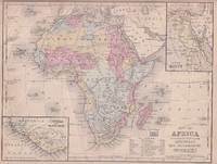
MITCHELL SAMUEL AUGUSTUS.
Map of Africa engraved to illustrate Mitchell's New Intermediate Geography.
Philadelphia.: E. H. Butler. circa1869. Lithographed map with original hand-colour 21.2 x 27.6 cm two inset maps of Liberia and Sierra Leone; and Egypt showing the Suez Canal text and engravings for an unrelated entry on the verso; margins dusty top edge worn with small edge tears one affecting the border and marginal chip but in good condition. Detailed map of Africa before the escalation of colonial acquisition in the 1880s. . (E. H. Butler). unknown
Bookseller reference : 176603
|
|
|
Mitchell, C. Bradford, Edwin K. Linen (Advice & Research Collaboration) & Frank Cram (Maps, Charts & Diagrams)
Every Kind of Shipwork: A History of Todd Shipyards Corporation 1916 - 1981
New York: Todd Shipyards Corporation. Fine. 1981. Hardcover. Hardcover apparently issued without a jacket this copy is inscribed signed and dated by the author on the title page: "For Charles Gertriser in appreciation C. Bradford Mitchell 6/22/81" and is also inscribed and signed by assistant Edward K. Linen on the title page: "Dear Charlie - Thanks for your cooperation. Hope you enjoy the book. Best regards Ed." Book is in excellent condition with no remarkable flaws a short article titled "Todd agrees to sell It's combustion line of products" and dated 3/6/69 is tipped-in on the front end-paper illustrated with many photos and maps of the company's ports; 320 pages; Signed by Author . Todd Shipyards Corporation hardcover
Bookseller reference : 054748
|
|
|
Mitscherlich, E.:
Geognostische Karte der vulkanischen Eifel. Farbige lithographische Karte von E. Mitscherlich.
48,5 x 59 cm. *Frühe Karte der geognostischen Erscheinungen der Eifel. - Zeigt das Gebiet zwischen Ormont, Jammelhoven, Beuren, und St. Thomas. Aus Mitscherlichs Werk: "Über die vulkanischen Erscheinungen in der Eifel". Mehrfache Falzspuren. Graphiken de
|
|
|
Mitsuhisa Takayanagi: Supervised by Historical Maps Co. Ltd.
Kosenjo All 2 Volumes Top and Bottom
A5 1st edition with box history book company 1978. Soft Cover. Fine. Number of books: 1 A5 1st edition with box, history book company paperback
Bookseller reference : 2081502112501891
|
|
|
Mitsumura Maps, Nire Publishing
Quarterly Flying Classroom 1.7.10.17.20-43.45 1981-1993 Supplementary Volume Creative Special 1992 30 volumes
Mitsumura Maps Nire Publishing 1993. Soft Cover. Fine. Number of books: 30 Mitsumura Maps, Nire Publishing paperback
Bookseller reference : 2082402113507248
|
|
|
Mittelbach
Mittelbachs Karten: Amiens-Abbeville-St. Pol. - Blatt 2
Approximately 23" x 19". Undated but probably from the early 20th century. Clean and unmarked with light wear. Some age-toning. A quality copy. Map

|
|
|
Mittelbach
Mittelbachs Karten: Arras - Cambrai - Peronne - Laon - St. Quentin, Blatt 3
Approximately 23" x 19". Undated but probably from the early 20th century. Bit of writing on bottom edge of map. Moderate wear. Some age-toning. A sound copy. Map

|
|
|
Mittelbach
Mittelbachs Karten: Paris - Compiegne Soissons - Chateau - Thiery, Blatt 4
Approximately 23" x 19". Undated but probably from the early 20th century. Unmarked with moderate wear. Some age-toning. A sound copy. Map

|
|
|
Mitton, Jacqueline; Balit, Christina (illustrator); Tirion, Wil (star maps).
Zoo in the Sky: A Book of Animal Constellations.
Sydney Mascot: Koala Book Company 1998. 1st Australian ed. Hardback oblong quarto very good condition pictorial cover illustrated endpapers colour drawings few light creases last page minor edgewear. 24 pp. Zoo in the Sky. A children's picture book by Jacqueline Mitton being a magical tour of the skies featuring 19 constellations named after animals birds and fishes. The poetic text supplemented by sky maps and background information about the stars combines with the beautiful incandescent paintings by Christina Balit to create a book that will fascinate children of all ages. Australian edition. Koala Book Company hardcover
Bookseller reference : 26621 ISBN : 0864611374 9780864611376
|
|
|
Mizuno Koshi / Meiji Maps, Meiji Maps
Japanese Language Education Analysis Theory and Practice Out of Stock
Not Available 1986. Soft Cover. Fine. The book is in fine condition. Not Available paperback
Bookseller reference : 2091202132900086
|
|
|
Mlle Le Normand
Grand jeu de societe et pratiques secretes
Paris, B.P. Grimaud Vers 1937
Bookseller reference : 37
|
|
|
Mlle LENORMAND
L'ART de TIRER les CARTES
Un ouvrage de 153 pages, format 135 x 180 mm, illustré, relié cartonnage couleurs, publié en 2011, Editions ESI, bon état
Bookseller reference : LFA-126750118
|
|
|
Mme de B.
Les patiences. Passe-temps récréatifs. Nouveau recueil complet.
Genève et Paris, éditions Cherbuliez 1867. Exemplaire broché (18x12), couverture usagée (manque 1 plat), 146 pages avec table.
Bookseller reference : AUB-1555
|
|
|
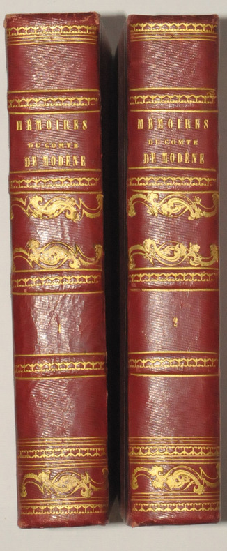
MODENE (Comte de).
Mémoires du Comte de MODENE, sur la Révolution de Naples de 1647. Troisième édition, publiée par J. - B. MIELLE.
Paris, Chez Félicien et Chatel, 1827. 2 volumes in-8, demi-chagrin rouge, dos ornés de filets dorés, 270 et 514 pages.
Bookseller reference : 7488
|
|
|
MODENE (Comte de).
Mémoires du Comte de MODENE, sur la Révolution de Naples de 1647. Troisième édition, publiée par J. - B. MIELLE.
Paris, Chez Félicien et Chatel, 1827. 2 volumes in-8, demi-chagrin rouge, dos ornés de filets dorés, 270 et 514 pages. Belle édition malgré une légère insolation sur les plats.
|
|
|
Modern Maps Hironobu Matsuda and others
Designing and manufacturing automation that can be done in any factory
Modern Maps Hironobu Matsuda and others 1973. Soft Cover. Fine. The book is in fine condition. Modern Maps Hironobu Matsuda and others paperback
Bookseller reference : 2083002116204312
|
|
|
Modern Maps Masami Fukuoka
Earth Pressure Retaining Calculation Method and Examples for Field Engineers
Modern Maps Masami Fukuoka 1980. Soft Cover. Fine. The book is in fine condition. Modern Maps Masami Fukuoka paperback
Bookseller reference : 2083002116202287
|
|
|
Moebius, Jodorowsky
Tarot : L'Incal (jeu de cartes en édition limitée)
Editions Le Diouris Jeu de cartes "Jeu de tarot ""L'Incal"", édition limitée à 2500 exemplaires numérotés (ici le n°2004), bien complet ; quelques frottements sur l'étui, par ailleurs bel état. Livraison a domicile (La Poste) ou en Mondial Relay sur simple demande."
Bookseller reference : vh4164

|
|
|
MOERENHOUT, J. A.
Voyages aux îles du Grand Océan, contenant des documents nouveaux sur la géographie physique et politique, la langue, la littérature, la religion, les moeurs, les usages et les coutumes de leurs habitants et considérations générales sur leur commerce, leur histoire et leur gouvernement depuis les temps les plus reculés jusqu'à nos jours.
Paris, A. Bertrand, 1837. 2 volumes in-8 (21,5x13,5 cm), xv, [1], 574 ; [4], 520, vii pp., illustré de 4 gravures et une carte dépliante, relié demi chagrin époque, traces de réparations à la reliure, cachets répétés, rousseurs et brunissures.
Bookseller reference : PHO-2283

|
|
|
Moffat, Alistair
Edinburgh
No marks or inscriptions. No creasing to covers or to spine. A very clean very tight copy with bright unmarked boards and bumping to lower rear corner. 176pp. Essentially a book of lovely photographs presenting an up-to-date picture of the Scottish capital accompanied by a short history.

|
|
|
Moffat, Alistair
Fife
No marks or inscriptions. No creasing to covers or to spine. A very clean very tight copy with bright unmarked boards and extremely minor bumping to spine top and lower rear corner. 176pp. Essentially a book of lovely photographs presenting an up-to-date picture of the Scottish region of Fife between the Forth and the Tay accompanied by a short history.

|
|
|
MOGALLI Niccolò- PETROSCHI Giovanni
Carta topografica delle Antichità di Roma…secondo il Giro metodico usato già dall'AB. Ridolfino Venuti…
Pianta topografica delle vestigia dell'antica Roma, a proiezione e figurazione verticale, pubblicata nel 1763 nell'opera di Ridolfino Venuti "Accurata, e succinta descrizione topografica delle antichità di Roma".Incisa da Niccolò Mogalli e Giovanni Petroschi, su disegno di R. Venuti.Le indicazioni toponomastiche in parte sono riportate nella pianta, in parte in una rubrica di 77 numeri posta ai lati. In basso, a destra, la firma degli incisori. La seconda edizione della lastra, reca la data 1823.Incisione su rame, in ottimo stato di conservazione. Pianta topografica delle vestigia dell'antica Roma, a proiezione e figurazione verticale, pubblicata nel 1763 nell'opera di Ridolfino Venuti "Accurata, e succinta descrizione topografica delle antichità di Roma".Incisa da Niccolò Mogalli e Giovanni Petroschi, su disegno di R. Venuti.Le indicazioni toponomastiche in parte sono riportate nella pianta, in parte in una rubrica di 77 numeri posta ai lati. In basso, a destra, la firma degli incisori. La seconda edizione della lastra, reca la data 1823.Incisione su rame, in ottimo stato di conservazione. Frutaz, Le piante di Roma, XXXVIII; L. Schudt, Le guide di Roma, p. 405, n. 769; Caldana (2013): p. 107, n. I.64.

|
|
|
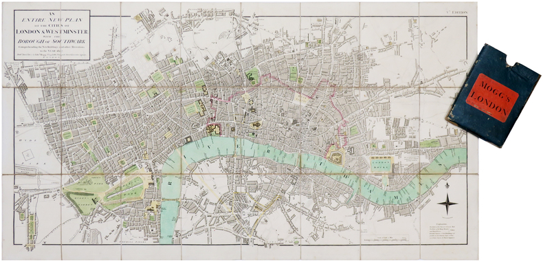
MOGG (Edward).
[LONDRES] An entire new plan of the cities of London & Westminster; with the borough of Southwark: comprehending the new buildings and other alterations, to the year 1807.
London, Edw.d Mogg, 1807. En deux feuilles coupées en 24 sections montées sur toile et pliées, formant une carte de 482 x 906 mm ; étui de papier bleu de l'époque avec pièce de titre de papier rouge.
Bookseller reference : LBW-7019
|
|
|
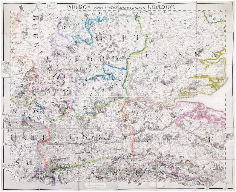
MOGG (Edward).
Mogg's forty-five miles round London.
London, Edward Mogg, June 1st 1821. En 36 sections montées sur toile et pliées, formant une carte de 0,96 x 1,16 m ; étiquette au dos de l'éditeur et marchand de cartes Charles Smith, actif entre 1800 et 1822.
Bookseller reference : LBW-6491
|
|
|
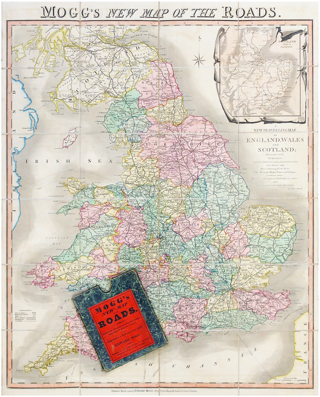
MOGG (Edward).
Mogg's new map of the roads - A new travelling map of England, Wales and Scotland.
Londres, Edward Mogg, 1830. En 24 sections montées sur toile et pliées, formant une carte de 770 x 630 mm ; sous étui de papier marbré vert de l'éditeur.
Bookseller reference : LBW-6506
|
|
|
MOISEL, Max
Karte von Kamerun, bearbeitet von M. Moisel H 1 , 2 : Kribi [ Echelle 1 / 300.000 ] [ Carte du Cameroun, sous la colonisation allemande ]
1 carte dépliante format 64 x 99,5 cm, Konstruiert u. gezeichnet v. W. Bobzin u. C. Jurisch. Abgeschlossen 15 August 1911
Bookseller reference : 47969

|
|
 Receive by email
 Download as PDF document
 RSS feed


