|
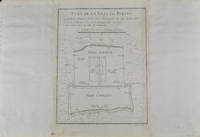
[BELLIN, JACQUES-NICOLAS]. (CARTOGRAPHER).
Plan De la Ville De Peking.
Paris. circa1749. Black and white engraved plan map of Peking on laid paper folded designed by the prominent French cartographer Jacques-Nicolas Bellin. This map is No. 18 Vol. 5 from the impressive 15-volume "Histoire Generale des Voyages" compiled by French novelist Antoine François Prévost. This city map shows two areas of walled cities: Ville Tartare Imperial city and the Forbidden City and Ville Chinoise ethnic Han residential area. <br> <br>Notes A and B represents buildings within the Forbidden City. A: Lieu de Plaisance ou l'on voit une Montagne faite a la main B: Grandes Cours du Palais de l'Empereur. Two missionary buildings French and Portuguese as well as the Tower of Mathematics illustrated within Ville Tartare. Two temples illustrated side by side near the south gate of the Ville Chinoise. <br> <br>Overall in good condition very light browning on edges and darker toning along the borders of the map. Text in French. Map measures 21 x 16.4cm. . unknown
Referentie van de boekhandelaar : 136794
|
|
|
[BIBLE DE GENEVE]; DESMARETS Samuel:
La sainte Bible, qui contient le Vieux et le Nouveau Testament : édition nouvelle, faite sur la version de Genève, reveuë et corrigée, enrichie, outre les anciennes notes, de toutes celles de la Bible flamande, de la plus-part de celles de M. Diodati, et de beaucoup d'autres, de plusieurs cartes curieuses, et de tables fort amples, pour le soulagement de ceux qui lisent l'Escriture sainte. Le tout disposé en cet ordre, par les soins de Samuel des Marets […] et de Henry des Marest, son fils [...].
A Amsterdam, Chez Louys & Daniel Elsevier, 1669. 4 parties en 2 tomes reliés en un volume in-folio, plein vélin estampé à froid, sur ais de bois. Traces d'attaches. [42]-366 ; [2]-162 ; [2]-202 ; 70 feuillets imprimés sur deux colonnes. *4; a-e6 ; f8; A-Z6 ; Aa-Zz6 ; Aaa-Ppp6 [et] A-Z6 ; Aa-Cc6 ; Dd8 [et] *2 ; A-Z6 ; Aa-Kk6 ; Ll4 [et] A-L6 ; M4.
Referentie van de boekhandelaar : 18982

|
|
|
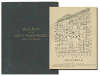
[Bicycling] : [Ohioana] : [Maps]
THE HAND=BOOK OF THE OHIO DIVISION L.A.W
Cincinnati Ohio: State Executive Committee League of American Wheelmen 1892. First Edition. 6 3/4" x 5 1/2." 184pp. Black cloth over boards. Gilt stamped title to front: "HAND-BOOK / OF THE / LEAGUE OF AMERICAN WHEELMEN / OHIO DIVISION." Without dust jacket. Outer cloth with some pervasive discolor a bit of raised wrinkling at front. Volume sound unmarked. About very good. <br/><br/>A scarce exceptionally well preserved handbook with detailed printed route maps of all 88 counties in Ohio issued to the state's membership of the League of American Wheelmen an organziation of early bicyclists originally assembled in Providence Rhode Island in 1880 and one integral in advocacy of the Good Roads Movement of the late 19th and early 20th Centuries. Uncommon in commerce. OCLC notes about 30 copies in American libraries though with many prominent institutions lacking. State Executive Committee, League of American Wheelmen hardcover
Referentie van de boekhandelaar : 2862
|
|
|
[BILLANCOURT].-
Sortie des ouvriers des Usines Renault.-
Carte postale E.M. 1431. Vers 1905. Carte postale (140 x 91mm) timbrée sur le recto (timbre presque entièrement déchiré). Vue très anîmée des bâtiments avec une grande foule d'ouvriers. Bon exemplaire.
Referentie van de boekhandelaar : ORD-1167
|
|
|
[Bird's Eye View Maps] : [Religion] : [France]
PELERINAGE DU CALVAIRE DU BIENHEUREUX DE MONTFORT Bird's Eye View Map of The Cavalry of Pontchateau
Paris France ca. 1910. Approximately 54cm x 42 cm 21 1/4" x 16 1/2". Broadside map black lithograph ink on paper. Single center fold. One square of toning at about center lower right in image. Two tiny closed tears about center fold at upper-center. Overall presents well. About very good. <br/><br/>An anonymous circa-early 20th Century bird's eye view map of The Calvary of Pontchateau religous site in Western France. With: "Imprimerie Francaise 52 Rue Des Archives Paris" printed at lower right. Scarce. unknown
Referentie van de boekhandelaar : 3262
|
|
|
[BLOCQUEL (Simon)]
Les Tours de Cartes les plus amusans, rendus faciles par un grand nombre de figures gravées.
1840 cartonnage modeste. in-16, titre, p.15 à 100, 9 planches comprenant 49 figures plus une sur le titre comprises dans la pagination, gravées sur bois. P. Delarue Lille Castiaux (ca. 1840)
Referentie van de boekhandelaar : 14296
|
|
|
[BORDEAUX]. DELPECH (Ernest).
Nouveau plan de la ville de Bordeaux à l'usage des promeneurs. Dressé d'après les documents les plus récents fournis par les administrations publiques par Ernest Delpech, employé aux travaux publics
Bordeaux, Féret [Imprimerie centrale de Vve Lanefranque], 1870 in-12, [2] ff. n. ch. (réclames), 32 pp. de texte (tableau des voies), [3] ff. n. ch. (réclames), avec un grand plan dépliant (58 x 73 cm) aux contours rehaussés de couleurs, toile chagrinée cerise, dos lisse muet, encadrements à froid sur les plats, titre et armes de Bordeaux poussés au centre du plat supérieur (reliure de l'éditeur).
Referentie van de boekhandelaar : 242581
|
|
|
[BOURDIN] [CARTES POSTALES ANCIENNES]
Le Riz d'Indo-Chine
Sans lieu, 1931. 1 ensemble de 6 cartes postales anciennes représentant les activités liées à la culture du riz en Indo-Chine.
Referentie van de boekhandelaar : 12245
|
|
|
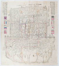
[BOXER REBELLION MAP OF BEIJING].
Map of Peking. 京城內外全圖 .Jing cheng nei wai quan tu.
Circa1900. Large illustrated map of Beijing showing the city in the period following the invasion of the military forces of the Eight National Alliance old folds scale not given. Some scattered light foxing particularly at edges short closed tear at fold lower edge neat non acidic tape repair short section upper edge wear along folds and a couple of small unobtrusive holes with minor image loss. Blocks of text in traditional Chinese right and left upper sections stating each nation's occupied zone Japanese text title accompanies the English title along the upper section of the map. 63.7 x 56.9cm. Very good overall. A rare and significant large Japanese woodblock map of Peking Beijing issued just after the suppression of the Boxer Rebellion. Centred on the Forbidden City the map depicts Peking following the multinational suppression of the Boxer Rebellion or Yihetuan Movement of 1900. The map was issued to illustrate the areas of occupation associated with each of the powers in the Eight Nation Alliance. <br> <br>The map gives measurements of the city walls detailed names of streets and buildings and the boundaries of the inner and outer city including the forbidden city are shown with demarcation lines in pink yellow and blue. The hand coloured eight national flags of the occupation powers are featured at the right and left. <br> <br>This map is essentially a later edition of 京城内外首善全圖 a map of Beijing issued by the Qing for administrative purposes in the mid-19th century. The Japanese seized the wood blocks during the suppression of the Rebellion and subsequently pulled new impressions overprinting them additional details including flags and demarcations of areas of the city held by members of the Alliance. Versions are known in French German Japanese and as with the present example English. An attractive map of great historical interest. . unknown
Referentie van de boekhandelaar : 169765
|
|
|
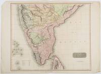
[BRITISH INDIA AND CEYLON - MAP] NEELE, SAMUEL JOHN. (ENGRAVER)
British India Southern Part.
London.: Thomson. 1816. Engraved map with full handcolour 50.5 x 59.7 cms ; 53.9 x 73.8 cms sheet central fold a few minor edge tears one intruding into the top border the map unscathed marginal edgewear two corners with some loss but the map in very good crisp condition. An elegant map with great detail prepared for John Thomson's influential "New General Atlas" 1814-1821. Showing India from 20 degrees to 7 degrees north of the equator and includes the northern half of Ceylon with territorial interests attractively coloured. . Thomson. unknown
Referentie van de boekhandelaar : 185242
|
|
|
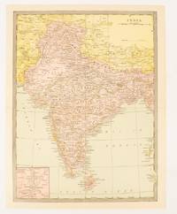
[BRITISH INDIA AND CEYLON - MAP].
India.
New York.: Bormay & Co. Circa1904. Map printed in colour 30.5 x 22.4 cm inset map of Calcutta and vicinity including the Nicobar and Andaman Islands at the outer edge slight puckering and discolouration at the central fold but in very good condition. . Bormay & Co. unknown
Referentie van de boekhandelaar : 174836
|
|
|
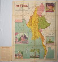
[BURMA - MAP]
Latest Map of Burma : political showing relief of land.
Delhi.: S.B. Makhija & Brothers. circa1951. Printed colour map 98.6 x 69 cms folding into pictorial wrappers 25.3 x 19.5 cms five pictorial colour inserts of pagodas and the Shwethalyaung reclining Buddha wrappers a little chipped marginal wear and three small fold splits in the map but overall in very good condition. Attractive large map of Burma with the provinces coloured steamship routes shown in red and printed in the booklet a range of information printed based on the 1951 census including climate agriculture and form of government "Burma became an independent nation completely outside the British Empire on January 4 1948 and is now a sovereign independent republic known as the Union of Burma". . S.B. Makhija & Brothers. unknown
Referentie van de boekhandelaar : 214601
|
|
|
[BYZANTINE EMPIRE - MAP]. SPRUNER, KARL AND MENKE,THEODOR.
Oströmisches Reich von der Einwanderung der Ungarn in Ponnonien um 895 bis zur Unterwerfung des Bulgarenreichs durch Kaiser Basilius im J. 1019.
Gotha: Justus Perthes. 1874. Map with original colour and outline hand-colour 32.2 x 40 cm three inset maps text in German central fold slight marginal toning in very good condition. A most handsome map detailing the Eastern Roman Empire from the immigration of Hungarians in Ponnonia around 895 to the subjugation of the Bulgarian Empire by Emperor Basilius in 1019. The inset maps depict Divisions of the Empire Palestine and the Themata around Propontis present day Sea of Marmara issued for the "Hand-Atlas für die Geschichte des Mittelatters und die Neueren Zeit". . Justus Perthes unknown
Referentie van de boekhandelaar : 174914
|
|
|
[CALIFORNIA -- MAPS]. [WHITE, Albert C., VINCENZ, Jean L.]
Land use district maps adopted by ordinance No. 2491 of the City of Fresno California. City Planning Commission. . . .
Fresno CA: City Planning Commission 1938. Oblong folio. 13.5 x 9.25 in. 17 blueprint maps variously numbered. w/ first map as the Key Map for the remainders. Stapled at gutter margin w/ protective green-tinted back softcover folded to provide reinforcement at spine from the library of George Reed Volker 1925-2018 former World War II pilot and urban planner in California New York and Washington State. First editions of these exceedingly scarce land use district zoning maps drawn up in 1938 after the passage of the 1937 Housing Act which unfortunately upended much of the spending not only by the WPA but also required any federal money to spent in “blighted†areas. These detailed maps show major streets demarcate singe family housing multi-family housing manufacturing and commercial bases for the community. Eventually the Public Housing which was built in Fresno during World War II began in West Fresno or “Chinatown first with the Sequoia Courts and later the Sierra Plaza followed by others. No copies located in Worldcat; See: Bibliography of Research Projects Reports W.P.A. Technical Series Research and Records Projects Bibliography No. 1 Feb. 2 1940 p. 53 Zoning Ordinance. City Planning Commission, paperback
Referentie van de boekhandelaar : 56963
|
|
|
[California] [Maps] [Eaton Fire]
MAP OF ALTADENA-PASADENA AND VICINITY
Atladena California: Altadena Federal Savings and Loan Association 1960. Printed on both sides on an 18 1/2" x 23 1/2" sheet of white paper that folds to 4" x 9 1/4" 24 panels. There is printing in red and a color rendering of the Altadena Federal Savings building on one side. Handwritten name on the front panel; else near fine. Scarce OCLC locates no holdings.<br /> <br /> Fully indexed street map of the unincorporated Los Angeles County California community that was devastated by the Eaton Fire in January 2025. Situated next to and within the foothills of the San Gabriel Mountains Altadena has long resisted annexation to Pasadena though that city has taken 46 "bites" of it over the years seeking tax revenues. That independent spirit is reflected in the mosaic of ethnic diversity that made Altadena one of the most integrated communities in Southern California. Altadena Federal Savings and Loan Association unknown
Referentie van de boekhandelaar : 78704

|
|
|
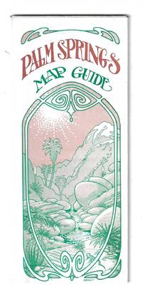
[California] [Maps]
PALM SPRINGS MAP GUIDE
Orange and Palm Springs California: Ken and Ruth Du Maurier The Palm Springs Map Guide 1976. Tourist map to the desort resort city in Riverside County California. In addition to a large street map of Palm Springs there are smaller maps of the city bus route Cathedral City and the Coachella Valley respectively. Also provides a list with addresses of movie star and celebrity homes a brief history of the region a description of the picturesque canyon areas and descriptive lists of local shops restaurants hotels golf courses activities service stations etc. Features photographic illustrations and numerous advertisements. Printed in green and desert rose on a 30" x 25 1/2" sheet of white paper that folds to 3 3/4" x 8 1/2" 48 panels. A fresh and clean example. Scarce OCLC locates only one holding at the Library of Congress. Ken and Ruth Du Maurier, The Palm Springs Map Guide unknown
Referentie van de boekhandelaar : 78705
|
|
|
[CAMPAGNE DE 1757]:
1. Mémoires pour servir à l'histoire des campagnes de 1756 et 1757 en Allemagne, par L. O. H., rédigés et augmentés par M. D. V. [avec] 2. Mémoires pour servir à l'histoire de la campagne des troupes françaises, depuis la convention de Closter Seiven faite en septembre 1757. Augmentée d'un lettre communiquée par l'observateur hollandais par rapport à la ditte convention. [avec] 3. Histoire de la campagne de MDCCLVII. Où l'on voit les circonstances qui ont précédé, accompagné, et suivi la battaille de Rosbach, avec le détail de ce qui s'est passé d'important dans l'Éléctorat d'Hannovre, depuis la convention de Closter-Seven jusqu'au 1 janvier 1758.
A Francfort et Leipsig, aux dépens de la Compagnie, 1758. In-8 de [4]-48 ; 32; 96-64 pages, demi-vélin à coins, titre inscrit à la plume sur le dos. Non rogné.
Referentie van de boekhandelaar : 21322

|
|
|
[CANAL DE SUEZ] Maclure & Macdonald Lithographers to the Queen London
LITHOGRAPHIE ORIGINALE : "A BIRD'S EYE VIEW OF THE SUEZ CANAL" , supplément gratuit du Journal "THE GRAFFIC" du 2 Septembre 1882, Maclure & Macdonald Lithographers to the Queen London,
London THE GRAFFIC 1882 broché une Vue lithographique en couleurs, Format : 26.7 x 10.25 inches ( 83 x 31 cm), supplément gratuit du Journal "THE GRAFFIC" du 2 Septembre 1882, Maclure & Macdonald Lithographers to the Queen London,
Referentie van de boekhandelaar : 28302
|
|
|
[Caribbean Maps]: Norie, J. W.
THE ISLAND OF ANTIGUA. Revised by J.W. Norie 1827
Antigua but actually Philadelphia: R.B. Eldridge & Co 1860. Lithographic sheet map 20 1/2 x 26 1/2 inches. Backed with contemporary blue paper. Light foxing and toning. A few small tears in margins. Very good. An unusual lithographic edition of Norie's 1827 revision of this handsome chart lithographed by Wagner & McGuigan in Philadelphia. A statement in the cartouche reads: "Presented by R.B. Eldridge Antigua to Captain Andrew Tyler." The captain's name is accomplished in manuscript. R.B. Eldridge is not listed in Tooley's DICTIONARY OF MAPMAKERS and appears to be unrelated to publisher of charts George Eldridge. It seems most likely that he was rather an Antigua merchant who commissioned a reprint of the chart for complimentary distribution to sea captains. A handsome piece. R.B. Eldridge & Co unknown
Referentie van de boekhandelaar : WRCAM48522

|
|
|
[Carte BLONDEL]
Carte FRANCE POLITIQUE, EMPIRE FRANCAIS, ZONE d'OCCUPATION en ALLEMAGNE
Une belle carte en couleurs, format ouvert 910 x 695 mm, éditée en 1931, Blondel La Rougery Editeur, bon état
Referentie van de boekhandelaar : LFA-126737235
|
|
|
[Carte d'Etat-Major]
CARTE d'ETAT-MAJOR : AUTUN
Carte géographique format ouvert 675 x 430 mm, éditée au début du XXe siècle, bon état
Referentie van de boekhandelaar : LFA-126714583
|
|
|
[Carte d'Etat-Major]
CARTE d'ETAT-MAJOR : RODEZ
Carte géographique format ouvert 675 x 430 mm, éditée au début du XXe siècle, bon état
Referentie van de boekhandelaar : LFA-126714593
|
|
|
[Carte de Dion-Bouton]
CARTE de DION-BOUTON I : NORD-OUEST PARIS
Carte géographique toilée format ouvert 660 x 640 mm, éditée au début du XXe siècle, bon état
Referentie van de boekhandelaar : LFA-126714596
|
|
|
[Carte de Dion-Bouton]
CARTE de DION-BOUTON II: NORD-EST PARIS + ALGERIE
Carte géographique toilée format ouvert 660 x 640 mm, éditée au début du XXe siècle, bon état
Referentie van de boekhandelaar : LFA-126714595
|
|
|
[CARTE de la HAUTE SAONE]
Département de la Haute Saône. décrété le 5 février 1790 par l'Assemblée Nationale
,
Referentie van de boekhandelaar : 239285
|
|
|
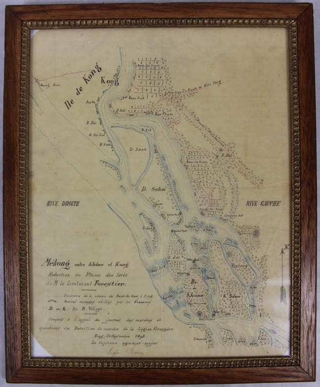
[Carte manuscrite] Pierroy (Capitaine)
Mékong entre Khône et Kong [Khong]. Réduction au 1/80000 des levés de M. le lieutenant Forestier. Croquis à l’appui du journal des marches et opérations du Bataillon de marche de la Légion étrangère.
Kong, 30 septembre 1893 Carte dessinée en couleurs 42,5 X 35 dans son cadre argenté. Bel état. Rare croquis exploratoire de ce secteur des Quatre mille îles du Mékong dont le franchissement nécessitera la construction d’une ligne de chemin de fer. L’officier reporte l’itinéraire de sa colonne de Hach-Ki-Koaï à Kong [Khong] et les anciens ouvrages édifiés par les Siamois.
Referentie van de boekhandelaar : 31781
|
|
|
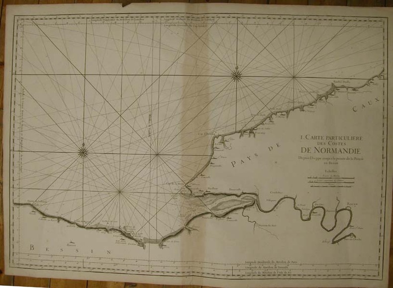
[CARTE MARINE - BELLIN]
I. Carte particulière des Costes de Normandie. Depuis Dieppe jusqu'à la pointe de la Percée en Bessin.
S.n.l.n.d. [Imp. Du Dépt. De la Marine,1753]. Grande carte marine sur vergé fort (88 x 63 cm), sans nom d'auteur ni de date, avec les échelles de mesure des longitudes et des méridiens sur le pourtour, notamment celui de l'Isle de Fer, une échelle des distances en lieues marines, terrestres et en toises (pliure au centre avec brunissure à l'emplacement de l'onglet).
Referentie van de boekhandelaar : 13358
|
|
|
[Carte MICHELIN]
CARTE MICHELIN n° 110 Zoom : ENVIRONS de LYON
Une carte dépliable, édition de 2004, Michelin, bon état
Referentie van de boekhandelaar : LFA-126740289
|
|
|
[Carte MICHELIN]
CARTE MICHELIN n° 36
Une carte dépliable format fermé 105 x 215 mm, format ouvert 430 x 1230 mm, publiée en 1919, Librairie Ch. Delagrave, bon état
Referentie van de boekhandelaar : LFA01b23
|
|
|
[CARTE]
Carte chorographique de la généralité d'Auvergne. Divisée par Elections, Dressée d'après nombre de Cartes, de Plans et Mémoires particuliers
A Paris, Chez Dezauche, 1786 carte dépliante de 55 x 76 cm repliée au format in-8, en feuille, imprimée en noir et mise en coloris (aquarellés) de l'époque, entoilée, étiquette de titre manuscrite au recto. Légère usure d'usage (petits trous à certaines pliures) mais néanmoins bon exemplaire.
Referentie van de boekhandelaar : 219186
|
|
|
[CARTE]
Carte des îles Britanniques. comprenant, outre quelques divisions romaines, les divisions primitives, saxonnes et actuelles, avec tous les noms géographiques cités dans l'Histoire d'Angleterre de M. Em. Lefranc
S.l. [Paris-Lyon], [Périsse], s.d. (1838) carte dépliante de 30 x 46 cm, contours rehaussés de couleurs, en feuilles, entoilées. Rousseurs.
Referentie van de boekhandelaar : 190961
|
|
|
[carte]
Carte du DEPARTEMENT de l'ISERE
Une carte format 330 x 430 mm, en couleurs, réimpression d'une carte de 1857 (dessinée par L. Garçon - Grenoble)
Referentie van de boekhandelaar : LFA-126727071
|
|
|
[CARTE]
Jura.
Paris, Hachette, s.d. (1910) 590 x 790 mm, carte dépliante en couleurs, broché.
Referentie van de boekhandelaar : 662711
|
|
|
[CARTE]
Mauriac. et le Nord Est du Bas Lim.. (sic)
A Paris, Chez Vignon, marchand de Cartes de Géographie, (fin XVIIIe) carte dépliante de 60 x 89 cm repliée au format in-8, en feuille, imprimée en noir et blanc entoilée, étiquette de titre manuscrite et étiquette ronde imprimée de l'éditeur au verso, onglet de vélin. Légère usure d'usage, renforcée aux plis, tache centrale, qques petites déchirures.
Referentie van de boekhandelaar : 219395
|
|
|
[CARTE]
N°52. CLERMONT. 1/200 000
Paris, Lanée, Succr de Longuet, (1900) carte dépliante de 51 x 73 cm repliée au format in-12, en feuille, imprimée en couleurs, entoilée, étiquette de titre imprimée ancienne de l'éditeur au verso.
Referentie van de boekhandelaar : 219397
|
|
|
[CARTE]
N°58. AURILLAC. 1/200 000
Paris, maison Andriveau-Goujon, Henry Barrère, (début XXe) carte dépliante de 51 x 71 cm repliée au format in-12, en feuille, imprimée en couleurs, entoilée, étiquette de titre imprimée de l'éditeur au verso. Quelques discrètes annotations manuscrites à l'encre noire.
Referentie van de boekhandelaar : 219399
|
|
|
[CARTE]
Picardiae, Belgicae regionis descriptio. Joanne Surhonio auctore. Cum Imp. et rég. Privilegio decenn 1579
(c.1579) 32.5 x 51 cm ( composition) - 42 x 56.5 cm (feuille), Mouillures. Pliures. Petite déchirure centrale sur l bord supérieur au niveau de la pliure.
Referentie van de boekhandelaar : 231868

|
|
|
[CARTE] [CAPITAINE (Louis)].
Marseille. Carte générale de la France construite sur l'échelle d'une ligne pour 400 toises par Capitaine L. - Flle 20
s.d. (c.1820) 59.5 x 91 cm (cuvette) - 80 x 110 cm (cadre), cadre en bois et stuc doré. Insolations. Petits manques au cadre.
Referentie van de boekhandelaar : 232928

|
|
|
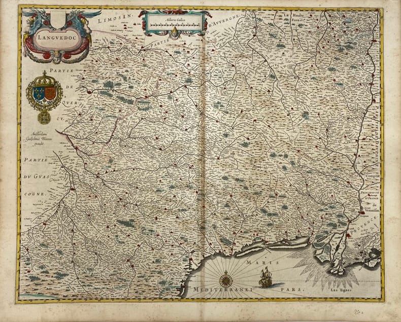
[CARTE] BLAEU (Willem Janszoon).
Languedoc.
Amsterdam, (c.1663) 44 x 54.5 cm (sans les marges) - 48.5 x 60 cm (feuille), texte portant sur le Languedoc au dos en Allemand, latin et grec ancien. Légères rousseurs et mouillures. Pliure centrale. Deux feuilles folios jointes. Traces d'encre au dos.
Referentie van de boekhandelaar : 231171
|
|
|
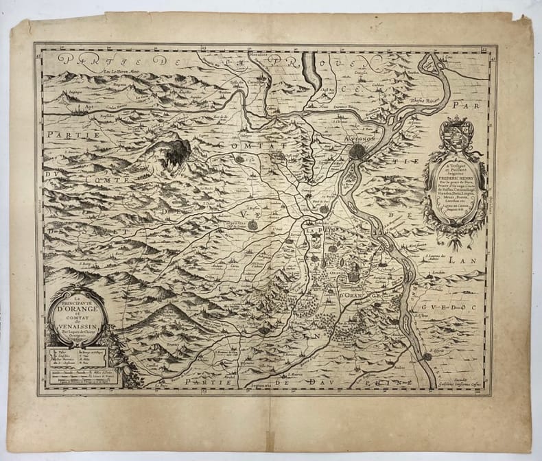
[CARTE] CHIEZE (Jacques de).
La principauté d'Orange et Comtat de Venaissin. Par Iaques de Chieze Orangeois.1627
[1627] 38 x 50 cm (cuvette) - 48 x 57 cm ( feuille), Quelques déchirures et petits manques en périphérie.
Referentie van de boekhandelaar : 231967
|
|
|
[CARTE] DEZAUCHE (Jean-Claude)
Théâtre de la guerre, entre les Turcs, les Russes et l'Empereur. Carte de la Mer Noire. comprenant la plus grande partie de l'Empire Ottoman, partie des Etats de l'Empereur, de la Russie, &c. Dressée par Dezauche, géographe, successeur des Srs. Delisle et Phil. Buache, premiers géographes du Roi, et de l'Académie royale des sciences
Paris, chez l'auteur [étiquette de Desnos apposée ultérieurement], 1788 carte in-folio de 80 x 104 cm, contours rehaussés de couleurs, en feuille.
Referentie van de boekhandelaar : 206667
|
|
|
[CARTE] FER (Nicolas de)
Les Provinces et gouvernemens du Lionnois, Forez et Beaujelois, de la Haute et Basse Auvergne, et du Bourbonois.
A Paris, chez l'Auteur, (c.1712) 48 x 64 cm (à vue), encadrée sous verre (cadre XXe siècle). Infimes pliures. Quelques déchirures à la marge.
Referentie van de boekhandelaar : 218132

|
|
|
[CARTE] SCHULER (Eugen)
Dislocations-Karte der Italienischen Armee. Nebst tabellerischer Uebersicht der Ordre de bataille und der Armeeverhälnisse im Frieden und im Kriege. Carta delle dislocazioni dell'esercito italiano
Wien, Artaria & Cie, Milano, Sacchi e Figli, 1891 in-4, carte dépliante en couleurs et un tableau dépliant, broché. Mouillures sur la couv.
Referentie van de boekhandelaar : 663606
|
|
|
[CARTE].
Carte routière, statistique & administrative du département de Maine & Loire. Dressée d'après les documents fournis par les administrations, principalement par celle des Ponts-et-Chaussées et le service des chemins vicinaux, par J. B. Fourcault, conducteur des Ponts et Chaussées, et publiée sous les auspices et avec l'approbation de Mr. Vallon, préfet de ce département (..). Dessinée sur pierre par H. Lagarde, sous la direction de l'auteur. 2me édition
Angers, Étienne Barassé, 1860 carte dépliante de 64 x 80 cm, contours rehaussés de couleurs, avec des cartouches latéraux et inférieurs, en feuilles, entoilées, sous chemise in-16 de toile verte (reliure de l'époque). Couvrure frottée.
Referentie van de boekhandelaar : 234191
|
|
|
[CARTE]. FRÉMIN (Antoine-Rémi).
Département de la Mayenne. Dressé par A. R. Frémin. Gravé par Artus et Bénard.
S.l. [Paris], s.d. (1840), carte dépliante de 56 x 72 cm, contours rehaussés de couleurs, avec une vignette gravée dans le coin inférieur droit (vue de Laval), en feuilles, entoilées.
Referentie van de boekhandelaar : 244750
|
|
|
[CARTE]. FRÉMIN (Antoine-Rémi).
Département de Maine-et-Loire. Dressé par A. R. Frémin, géographe. Gravé par Artus et Bénard. Carte autorisée le 26 février 1841 par le Conseil royal de l'instruction publique, et recommandée aux recteurs des Académies par le Grand maître de l'Université.
Paris, Dusillon, s.d. (1842), carte dépliante de 56 x 72 cm, contours rehaussés de couleurs, avec une vignette gravée dans le coin supérieur droit (vue d'Angers), en feuilles, entoilées.
Referentie van de boekhandelaar : 244751
|
|
|
[CARTES A JOUER - BOSTON].
Tablette de marque du Jeu du Boston.
Tablette recouverte de papier maroquiné rouge, décor de roulettes dorées sur les plats, ardoise façon vélin pour la marque de points d'un coté avec son crayon en étain, tableau imprimé des paiements du Boston au verso, Molette tournante pour le comptage des points (quelques usures sur les tranches). Dix-neuvième siècle, (100 x 155 mm). Bon état compte tenu de la fragilité de l'objet.
Referentie van de boekhandelaar : 20567
|
|
|
[CARTES A SYSTEME]
Deux cartes romantiques à système en couleurs.
Augsburg, T.V. Poll, (début du XIXème). Deux cartes de 7 x 10,5. Très bon état.
Referentie van de boekhandelaar : 9134
|
|
|
[Cartes A. Taride]
CarteDe Reims à la Somme
Carte dépliante couleur, échelle : 1 : 200.000, A. Tarde éditeur, Paris, SD
Referentie van de boekhandelaar : 5787
|
|
|
[Cartes A. Taride]
Nouvelle Carte Routière des environs de Paris dans un rayon de 60 Kilom. à l'usage des automobilistes, cyclistes, Touristes 1/ 100 000eComprenant : Chantilly, Corbeil, Etampes, Fontainebleau, Mantes, Meaux, Melun, Rambouillet, Senlis, etc., etc.
Carte routière couleur dans son étui d'origine, A. Taride Libraire-Editeur, Paris, SD
Referentie van de boekhandelaar : 5775
|
|
 De zoekresultaten per email ontvangen
 Zoekresultaten downloaden als PDF
 RSS feed


