|
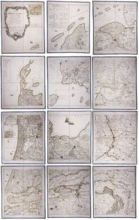
[Kartographie - Heiliges Land]. - Wajntraub, Eva u. Gimpel
Hebrew Maps of the Holy Land.
Wien, Brüder Hollinek, 1992. 4°. Mit zahlr. tlw. ganzs. bzw. farb. Abbildungen. XXIV, 277 S., OLwd. m. illustr. OUmschlag.
书商的参考编号 : 54498
|
|
|
[Kartographie - Japan]. - Yamashita, Kazumasa
Japanese Maps of the Edo Period.
Honkomagome-Bunkyok-Tokyo, Kashiwashobo, 1998. 4°. Mit zahlr. Abbildungen. 270 S., 1 Bl., OLwd. m. illustr. OUmschlag.
书商的参考编号 : 54500
|
|
|
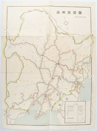
[KIKUCHI, KIYOSHI, EDITED BY]. 菊池清編輯.
満洲鉄道図. Manshu tetsudo zu. Railway Map of Manchuria.
奉天. Mukuden.: 満鉄鉄道総局. Mantetsu Tetsudo Sokyoku. 昭和 15 1940. Colour folded map seven small very holes not affecting the printed image otherwise good. 53 x 38.5cm Map showing the comprehensive railway network in Manchuria with names of all the stations. It includes the lines run by the South Manchurian Railway Company their temporary industrial lines light rail as well as the lines run by other Russian and Chinese companies. By 1940 the network had expanded so much that it included almost the whole of Manchuria. . 満鉄鉄道総局. [Mantetsu Tetsudo Sokyoku]. unknown
书商的参考编号 : 172590
|
|
|
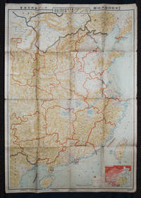
[KINGU HENSHū-KYOKU / KINGU EDITORIAL OFFICE] キング編輯局.
最新支那明細大地圖/滿・蒙・ソ聯國境大地圖. Saishin Shina meisai daichizu / Man Mō Soren kokkyō daichizu. Latest Large Detailed Map of China/Large Map of Manchuria Mongolia and the Soviet Union Borders.
Tokyo: 大日本雄辯會講談社 Dainihon Yūbenkai Kōdansha. Shōwa 13. 1938. Two large detailed maps of China and on the reverse of the Soviet Union in Asia Manchuria and Mongolia printed double sided on a single large sheet. Issued as a supplement to Volume 14 Number 1 of the magazine Kingu on New Year's Day in 1938. <br> <br>Holes at a number of holes causing a small amount of loss some occasional browning some chipping on margins. The map has clearly been used but is still largely complete. The colourful map of China on a scale of 1:2600000 includes part of Manchukuo and Inner and Outer Mongolia on the north and part of French Indochina to the south-west. It shows East Hebei Autonomous Anti- Communist Council Jidong Fanggong Zizhi Zhengfu 冀東防共自治政府 south of Manchukuo which existed from late 1935 until February the 1st1938. The legend includes national and provincial borders cities roads railways sea and air routes and undersea cables. There is an inset map of East Asia titled "Present Situation of Far East" on the lower right corner which shows the areas under influence of Communism and those under influence of/controlled or colonised by the United Kingdom France Japan and China. <br> <br>The map on the reverse printed in blue and black shows the Asian section of the Soviet Union Manchuria and Mongolia on a scale of 1:3000000. There is an inset map of Asia titled "Asian Continent" at the upper left corner the area enclosed by a rectangle which indicates the area covered in this map. The legend includes cities railways roads national borders district borders province borders and air routes. . 大日本雄辯會講談社 [Dainihon Yūbenkai Kōdansha]. unknown
书商的参考编号 : 159295
|
|
|
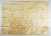
[KIZAKI, JUNICHI]. 木崎純一.
最新詳密蘇連極東地方大地図. Saishin shomitsu Soren Kyokuto chiho dai chizu Most Recent and Detailed Large Map of the Soviet Union and Far East Region.
東京. Tokyo.: 伊林書店. Ibayashi Shoten. 昭和14 1939. Colour printed folding map 78 X 109cm minor damage original envelope 27.5 x 20cm. Very good copy. This map offers comprehensive information on northern China Manchuria the Soviet Union and Hokkaido including Kuril Islands under the Japanese control. It also includes the Jewish Autonomous State which existed in the late 1930s. The inset map provides detailed information on the border area of Japan Manchuria and the Soviet Union. Legends include national borders railways major cities iron mines and oil wells. <br> <br>Published in 1939 this map is an expression of the tension Japan felt in its relationship with the Soviet Union. At the time the Soviet Union was seen as the mighty threat to the lying just north of Manchuria and Japan . . 伊林書店. [Ibayashi Shoten]. unknown
书商的参考编号 : 171112
|
|
|
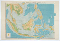
[KOYAMA, KICHIZO]. 小山吉三.
蘭領東印度諸島詳圖 附泰國・佛印・マレー半島. Ranryo Higashi-Indo Shotoo shozu : Fu Taikoku Futsu-In Mare Hanto. Malay Archipelago.
東京.Tokyo.: 日本名所圖繪社.Nihon Meisho Zuesha. 昭和16 1941. Folding colour Japanese map of the Malay Archipelago and Thailand scale 1: 8500000 with attractive original pictorial paper envelope. This map also shows the Dutch French and American colonies. Hainan Province and the South China Sea are shown in the north. Agricultural and mineral resources indicated across the map. Few small holes at holes and other light signs of wear. Slipcase lttle torn. Text in Japanese and English. 53.3 × 78.2cm. . 日本名所圖繪社.[Nihon Meisho Zuesha]. unknown
书商的参考编号 : 160538
|
|
|
[La RECHERCHE]
LA RECHERCHE
N° 176 - Avril 1986 Une revue d'environ 140 pages, format 295 x 220 mm, brochée, illustrée
书商的参考编号 : LFA00876
|
|
|
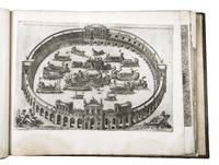
[LAFRERI - DUCHETTI - FLORINI - MAPS AND ENGRAVINGS - ITALY].
Large album with 16th-century maps and engravings of Italy.
Italy 1550. Large oblong folio ca. 59 x 42.3 cm. 17th-century gold-tooled brown calf sewn on 6 supports with the corresponding raised bands on the spine a red morocco title label on the spine with the title "Novissima urbis Romae descriptio" lettered in gold gold-tooled board edges. With 76 full-page engravings and 12 full-page etchings. Remarkable album with 77 beautiful examples of 16th-century Italian cartography all in very fine dark impressions. The collection includes plans of important Italian towns such as Rome Venice Genoa Naples Milan Florence Palermo Siena Bologna and Pisa as well as detailed views of individual buildings and monuments in Rome. They are engraved by several cartographers from the school of Antonio Lafreri 1512-1577 primarily Claudio Duchetti d. 1585 Matteo Florimi d. 1613 and Lafreri himself. Florimi's works are among the rarest of the Lafreri school map makers especially his Siena imprints of which several have here been included.In the middle of the 16th century Italy was the centre of map production and distribution in Europe. This industry primarily took place in Venice and Rome. The most notable of the publishers in Rome was Lafreri. His most important and most popular work is the Speculum Romanae magnificentiae a collection of plans an views of Rome's monuments; no two copies of the Speculum are the same. The present collection contains more than thirty plates from the Speculum. When Lafreri died his nephew Claudio Duchetti inherited the company. He continued to produce the Speculum plates but often made small adjustments and signed his own name at the bottom. Most of the Speculum plates in the present album are by Duchetti. After his death the copperplates were sold to other publishers such as Giovanni Orlandi before 1590-after 1640 who reissued them. The majority of the plates in the present album were printed by Orlandi in 1602.The album further contains 32 engraved city plans mostly of Italian towns although a few foreign cities are also included; one of the rarest is the view of Moscow which is also included here. The collection ends with a incomplete series of 11 etchings of landscapes and biblical scenes.A list of contents is available upon request.With the bookplate of Louis Routy de Charodon seigneur de Grésigny and Charodon 1710-1794 on the front pastedown and remnants of another bookplate above. The boards are somewhat scratched and stained the spine shows traces of use the edges of the boards have been professionally restored and the boards have been lengthened to fit the maps. The maps are slightly browned some are slightly foxed the first few maps have been mounted onto 17th-century leaves the longer maps are somewhat soiled on the fore edge three maps are restored at the fore edge and one at the bottom edge some maps have been cut slightly short. Otherwise in good condition.l Cf. Parshall P. "Antonio Lafreri's "Speculum Romanae magnificentiae"" in: Print Quarterly vol. 23 1 2006 pp. 3-28. hardcover
书商的参考编号 : ABC_49514
|
|
|
[LAND SURVEY DEPARTMENT, EMPIRE OF JAPAN]. 大日本帝国陸地測量部.
上海 支那江蘇省・浙江省. Japanese Map - Shanghai Jiangsu Province and Zhejiang Province.
Tokyo.: 大日本帝國陸地測量部. Dainihon Teikoku Rikuchi Sokuryōbu. Taisho 15. 1926. Folding colour Japanese map of Shanghai and coastal areas of Jiangsu and Zhejiang Provinces. Scale 1:100000 embossed stamp lower right corner. Legend lower edge showing different landforms on the left section forests deserts wildlands plateaus rivers and lakes middle section showing various facilities such as post offices telecommunication offices temples ancestral halls ancient battle ground mines military fortifications submarine communications cables city walls and gates etc. right section showing different sizes of cities towns and villages and administrative boundaries. <br> <br>Occasional foxing along edges and folds ink annotation in Kanji on reverse good copy. Text in Japanese. Sheet measures 45.2 x 57.7cm. This very detailed map was originally surveyed by the Land Survey Department Empire of Japan in Taisho 7 1918. This revised edition features the railway line connecting Hangzhou - Jiashan - Shanghai - Suzhou - Wuxi. . 大日本帝國陸地測量部. [Dainihon Teikoku Rikuchi Sokuryōbu]. unknown
书商的参考编号 : 173266
|
|
|
[LAND SURVEY DEPARTMENT]. 陸地測量部.
東部亜細亜圖. 五百万分一. Tobu Ajiazu. Gohyakumanbunnoichi. East Asia. 1:5000000.
Tokyo.: 大日本帝國陸地測量部. 昭和14 1939. Large colour folding Japanese WWII map. Scale 1:5000000 featuring Japan Korea Taiwan Karafuto Eastern China parts of French Indochina and the Northern Philippines US colony in detail. Legend includes territorial boundaries national and regional and shows some borders as unclear i.e. Taiwan and bordering region along Northeast China the Soviet Union and Mongolia air routes submarine communication cables linking major costal cities i.e. Hong Kong Xiamen Shanghai Nagasaki etc. airports radio stations mining fields and more. A small chart shows the names of mountains rivers and lakes also included adjacent to legend. Some small holes at folds creases and some minor loss edges generally very good. Text in Japanese. 109 x 77.8cm. . 大日本帝國陸地測量部. unknown
书商的参考编号 : 160524
|
|
|
[LATE 19TH CENTURY MAP OF THE MEDITERRANEAN].
Mediterranean Sea.
circa1890s. Attractive late 19th Century map 19.6 x 24.9 cm 23.7 x 32.4 cm sheet tinted border and crudely applied but not unattractive outline hand colour some toning to the margin and the lower margin a trifle discoloured but in good condition. . unknown
书商的参考编号 : 175249
|
|
|
[LEBECK (Robert)].-
Le Baiser. 80 cartes postales anciennes rassemblées et publiées par Robert Lebeck. Postface de Jurgen Kesting.
1981 Paris, Duculot, 1981, in 12 broché, 174 pages ; couvetrure illustrée.
书商的参考编号 : 75568
|
|
|
[LILLE]
Plan de Lille, de la citadelle, et de ses environs.
A Paris, chez le sieur Le Rouge, s.d. 67 x 54 cm.,
书商的参考编号 : 175648
|
|
|
[LILLE] FRICX (Eugène Henry).
Présenté à S.A.S. Monseigneur le Prince Eugène de Savoye. Plan de la citadelle de Lille. Laquelle, après que la Ville fut prise le 22 octobre, on a aussi commencé d'attaquer sous le commandement de S.A. le Prince Eugène de Savoye dès le 29 [..]
Bruxelles, Eugène Henrÿ FRICX, 1709 sans les marges : 42 x 54 cm - cadre : 60.5 x 70.5 cm, cadre contemporain à baguettes. Pliure centrale. Quelques taches.
书商的参考编号 : 230822

|
|
|
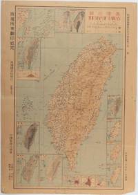
[LI CHENGSAN]. 李承三 (EDITOR).
臺灣地圖. Taiwan ditu. Taiwan Map.
Taiwan.: 禹甸圖書局. Yudian tushuju. 1945. 1945 Ministry of Interior map of Taiwan published in the 34th year of the Republic of China with inset title and key top right. Romanised Japanese names for some areas and cities written in capital letters on main map which is surrounded by 15 small inset maps at edges each with its own scale. Paper browned wear at folds and edges repaired with archival washi on reverse some light stains and a few marks. 1 x 3cm chip bottom right corner. 77.4 x 54 cm. Text in traditional Chinese characters. Inset maps show clockwise from right edge; 1. Distribution of inhabitants according to ethnic background or minority group 2. Qing Dynasty prefectures and counties 3. Japanese administrative regions during the occupation 4. Strategic industrial and military places three city maps - 5.Chilung or Keelung port 6. Taipei city and 7. Tainan city 8. Geological formations 9. agricultural metallurgical and mineral products 10. Soil types 11. Topography of the island including sea currents and altitude diagram 12. Taiwan's position in relation to the mainland coast provinces of Fujian and Zhejiang as well as the Liuqiu Ryukyu Islands including Okinawa 13. Okinawa detail 14. Climate and rainfall in January 15. Climate and rainfall in July. . 禹甸圖書局. [Yudian tushuju]. unknown
书商的参考编号 : 215871
|
|
|
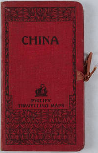
[LINEN BACKED MAP OF CHINA]
China. Philips' Travelling Maps Cover Title.
no date. circa1920. Linen backed colour folding map of China insets of Peking and Environs and Hongkong and Canton in lower left corner. 54 x 63.8cm. Table of place names at upper left gives the cities that "By a recent ordinance of the Republic all 'Fu' 'Chow'' and 'Ting' cities have been nominally reduced to the rank of 'Hsien'. The following parallel list gives the 'Fu' cities the names of which have been officially changed together with the new form adapted." Map folds into a red cloth covered case with ribbon ties 19 x 10.3cm. Title and decoration printed in black on upper cover. Trifle foxed on linen backing a little insect damage case in a few small places otherwise a very good clean map. . hardcover
书商的参考编号 : 161936
|
|
|
[LORRAIN] - TEXIER (Fabienne)
Metz il y a 100 ans.
Prahecq, Éditions Patrimoines et Médias, 2010 ; in-4 oblong, 140 pp., cartonnage imprimé d'éditeur. Oeuvre illustrée en cartes postales anciennes, photographiées et en couleur. Iconographie des archives municipales de Metz avec la participation du maire de Metz Dominique Gros.
书商的参考编号 : _202100367

|
|
|
[London Fire Force; Metropolitan Water Board; Fire Fighting in the Second World War; maps and plans]:
Lithographic coloured London Fire Force plan indicating the wartime Emergency Water Supply to the Trafalgar Square and Whitehall area of London headed 'E. W. S. No. 284 Plan referred to on Sheet No. 10 Water Unit Maps re Government Buildings'.
Without date or place. London Fire Force circa 1943. On one side of piece of 41 x 20.5 cm paper with lines and indications in light and dark blue red and green. In fair condition on aged paper with creasing and one closed tear towards the head. The map has Trafalgar Square at its head with the note that the two 'Basins' carry '40000 Galls. each' and Parliament Square at its foot. Whitehall and Parliament Street connect the two on the right of the map and to the left of the map is the lake in St James's Park: '200000 Galls Underground Tank Pumping Station 1400 Galls Pump 15 foot Gravity Main from Serpentine'. Also marked on the map are 'Inlet connections for L.F.F. Pumps and Pits' '6 Signle Outlet Suction Hydrants Round Thread' and 'Two 6 foot Steel Pipes in Subway Also under Embankment in Subway'. Down the centre of the map are the government buildings: the Admiralty Treasury Downing Street Foreign and Colonial Offices India Office and Home Office Office of Works Board of Education Board of Trade and Ministry of Health. No other copy found listed.Image on application. Without date or place. (London Fire Force, circa 1943.) unknown
书商的参考编号 : 14486
|
|
|
[London]; [Railroads]; [Maps]; Stephenson, Robert
London Birmingham Railway; Plan of the Line and Adjacent Country
London: Cha. F. Cheffins 1835. Map. Ex-Library. 29 3/8" x 61.5". Linen-backed map done on two sheets. Map printed in black pink yellow and green hand-colored. Housed in a 8" x 5.5" green case with gilt lettering and a gilt device on the front board the front of the case states "London & Birmingham Railway. Map of the Line. above the device Incorporated 6th May 1833". A portion of the map backed with green goat in order to have it enter and exit the case more smoothly. A large and beautiful representation of the London to Birmingham railway line with the stops outlined at the bottom edge of the map. With two engraved vignettes showing the depots in Birmingham and in London. An early example of this captivating map. A bookplate and one stamp on the verso of the map otherwise no markings. The bookplate states that the map was a gift donated by James J. Hill a wealthy bibliophile from St. Paul to the University of Wisconsin Library. The map has three small spots of loss to its folds. The case has wear and light discoloration. Cha. F. Cheffins unknown
书商的参考编号 : 000014144
|
|
|
[LORRAIN] - TEXIER (Fabienne)
Metz il y a 100 ans.
Prahecq, Éditions Patrimoines et Médias, 2010; in-4 oblong, 140 pp., cartonnage imprimé d'éditeur. Oeuvre illustrée en cartes postales anciennes, photographiées et en couleur. Iconographie des archives municipales de Metz avec la participation du maire de Metz Dominique Gros.
|
|
|
[LYONNAIS].-
Cartes du Ministère de l'Intérieur au 1/100.000e. LYON en 4 cartes (Sud-Est - Sud-Ouest - Nord-Est - Nord-Ouest) présentées repliées en 4 portefeuilles rouges au format 10X16. Edités par la librairie Hachette dans les tirages de 1898-1900.
书商的参考编号 : 56101
|
|
|
[Manche - Traversée de la]
Carte du pont sur la Manche.
Avant-projets présentés par Schneider et Cie (du Creusot) et H. Hersent à l'Exposition Internationale de Paris en 1889 (94 x 32 cm), lithographiée en couleurs.
书商的参考编号 : 10845
|
|
|
[MANUSCRIT]
Carte figurative de la seigneurie de Beaufremez. appartenant au Sr. Gille Le Cat seigneur dudit Beaufremez, Clicquenoy, et., situé ès paroisses de Bondue [Bondues], Marcq [-en-Bareul], et environ, dont l'explication et grandeurs de chaque partie de terre avecq les tenans et aboutissans se trouve par l'acte jointe [sic], fait par le soubsigné arpenteur juré, et arresté le trentiesme de may mil sept cent dix-huit
S.l.n.d. (1718) grande carte in-4 oblongue (37 x 82 cm), contours rehaussés de couleurs, avec une échelle en verges dans le coin droit, en feuille. Traces de mouillures, petit manque de papier sans gravité.
书商的参考编号 : 190576
|
|
|
[MANUSCRIT]
Projet d'attaque d'une place étrangère. Fait et dessinné [sic] par le sous-lieutenant élève d'artillerie Demarçay. Autographié par Em. Baur
Fontainebleau, 31 janvier 1876 in-folio oblong (68 x 96 cm), en feuille, bord supérieur ébarbé.
书商的参考编号 : 208488
|
|
|
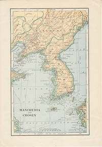
[MANCHURIA & KOREA - MAP].
Manchuria and Chosen
London. Circa1900. Map printed in colour showing submarine and overland telegraphs Manchuria Chosen Liao-Ting Kirin and Chili 21.5 x 13.3 cm 25.7 x 17.1 cm sheet size margins a little scuffed in very good condition. . unknown
书商的参考编号 : 174813
|
|
|
[MANUSCRIPT - MAPS - INDONESIA - ISLANDS in the PACIFIC OCEAN].
Suitte du journal depuis le départ de Manille NIII 1755.
1755. Manuscript of 24 pages 6 printed maps on cardboard. This wonderful logbook details the journey of a French captain from Manila to the Maluku Islands in today’s Indonesia. The journey took place during the months of March to May of 1755. The captain of the ship recounted with great detail the events of every day of the journey with detailed daily accounts of the weather winds manoeuvres of the ship its departures anchorages and precise coordinates at every point of the journey. The captain furthermore had a keen eye for the geographical and nautical details along the journey. He recounted the exact locations of for example sandbanks and bays where ships and their crews can take provisions and fresh water. The accounts are detailed and captivating: "After our boats were back on board we set sail . in the afternoon to moor under the old Portuguese fort on the Solor island Indonesia the winds for the tide were fresh at 1:34 a.m. . sand and gravel and then I went back to mooring. The pavilion of the fort . the village is under the said fort at 3 cables from us .". The captain goes on to describe the geographical features of the islands as well as other places en route with great detail. Curiously we find inscriptions in Spanish and the names of one don Phelipe Qui who describes himself as “el piloto” and one Padre Don Estevan de Melo. The latter might be identical with Don Estevan Roxas y Melo a native of Lima Peru and secretary to the Archbishop of Manila Rodriguez since 1736. Roxas y Melo was part of the 1751 reconstruction of the Cathedral of Manila working under the auspice of the Italian architect Juan de Uguccioni.The logbook comes with six printed maps partly illustrating the journey of the captain pasted on contemporary cardboard. They depict the Bay of Sulavesi with the city of Bantang Pitcairn the coast of New Guinea the coast of Queensland the Santa Cruz Islands in the present-day Solomon Islands and Alejandro Selkirk Island. The plates stem from the French translation of James Hawkesworth’s An Account of the Voyages Hawkesworth Relation des voyages entrepris par ordre de sa Majesté Britannique actuellement regnante; pour faire des découvertes dans l'hemisphère meridional Paris 1774.Some holes on the first sheet not affecting the text. Small water damage some slighlty affecting the text. Remnants of seals on last page. Otherwise in good condition. unknown
书商的参考编号 : ABC_47452
|
|
|
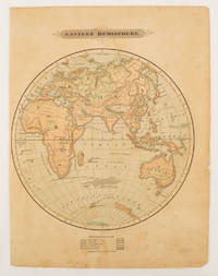
[MAP - EASTERN HEMISPHERE].
Eastern Hemisphere.
Harper & Brothers. 1875. Spherical map printed in colour 21.3 x 21.2 cm with shaded key to elevation and ocean currents unrelated text on the verso paper toned and margins soiled bottom edge ragged small sealed to to the inner margin but in sound condition. Map showing the five continents of Asia Africa Antarctica Europe and Australia. Published by Harper & Brothers for inclusion in their "School Geography". Plateau of Tibet very prominently marked. Gobi Desert and Plateau of Mongolia also marked India described as Hindostan Indo-China includes Thailand. . Harper & Brothers. unknown
书商的参考编号 : 175128
|
|
|
[Map - Saudi Arabia - Jordan].
USAF aeronautical chart and information service. World aeronautical chart (446) Wadi Sirhan. Washington, D.C., AAF Aeronautical Chart Service, 1945.
Colour-printed map, 730 x 560 mm. Scale 1:1,000,000. On verso: legend, aeronautical information, and index map. First edition. - Pilot's map of Wadi Sirhan in the border region of Iraq, Saudi Arabia and Transjordan. It shows international boundaries populated places, roads and tracks, railways, wireless telegraph stations, forts, wadis, wells, vegetation and terrain features. Shows also parts of Transjordan and Iraq, including the zigzagging border between Saudi Arabia and Transjordan. - In excellent condition.
|
|
|
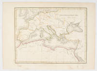
[Map of Arabia.] Brion de la Tour, Louis.
Perse, Turquie Asiatique et Arabie. Paris, Louis Charles Desnos, 1799.
Engraved map in original outline colour. Flanked by two mounted columns of French text. Very fine map of Arabia by the “Ingénieur-Geographe du Roy” Louis Brion de la Tour (1756-1823) showing Turkey, Palestine, present-day Iraq and Iran, the Caucasus region as well as the Arabian Peninsula. Cf. National Maritime Museum Cat. I, 264. Not in Al Ankary; Al-Qasimi.
|
|
|
[MAP OF KUALA LUMPUR IN 1962].
Kuala Lumpur. Published under the direction of the Surveyor General Malaya.
Kuala Lumpur.: Survey Department Federation of Malaya. 1962. Very attractive large coloured folding map 108 x 83cm showing all the major hotels and rest houses throughout the country. Coloured references show rubber rice coconut and oil palm areas pineapple and miscellaneous cultivation areas mining land jungle built-up areas and shopping centres along with major features such as rivers principal roads minor roads and cart tracks railways lighthouses district state and international boundaries and triganometrical stations with heights. Scale 18 miles to an inch mile. Two inset maps of Northern Malaya and South Western Malaya are 9 miles to an inch. There are smaller inset maps of Ipoh; Malacca Singapore & Johor Bahru Penang Sungei Patani Kuala Lipis Kuantan Alor Star Kota Bharu Petaling Jaya Seremban Klang Batu Pahat Muar Segamat Johore Bahru and a small inset map of Malaya and adjacent territories. There is a large black & white table of approximate mileages. When folded the map is encased in the original printed manila covers measuring 21 x 14cm with a printed price of $2.50. A crisp bright map in very good condition. Survey Department Federation of Malaya No. 23. . Survey Department Federation of Malaya. unknown
书商的参考编号 : 174808
|
|
|
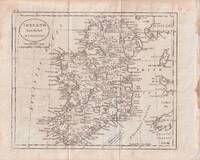
[MAP] [CARY, JOHN, AFTER]
Ireland from the best authorities
circa1796. Engraved map 18.3 x 22 cm 21.7 x 27 cm sheet original folds age toning and some offsetting inner edge darkened and discoloured but the map in good condition. Finely engraved map showing Ireland divided into counties lower coast of Scotland and Wales and the Isles of Man and Anglesea; also noting Nymph Bank 'discovered in 1735 by Capt. Doyle.' . unknown
书商的参考编号 : 176602
|
|
|
[Mappa Mundi - Africa and Asia].
Hand-drawn map of the Southern Hemisphere. No place, 17th or early 18th c.
Ca. 195 x 293 mm. Ink on vellum primed with gesso, annotated in Latin. An early map of Africa and Asia south of the Equator, Indonesia largely obscured by a defect to the upper right corner. Tristan da Cunha is identified, as well as the Antarctic Circle. The map also shows the hypothetical southern continent Terra Australis Incognita, merging into New Guinea at the very right edge of the vellum sheet. The "unknown land of the south" was first posited in antiquity and appeared on maps between the 15th and 18th centuries before its existence was finally disproven by the voyages of James Cook, which instead established the existence of Australia more or less in its place. - Ink rather faint in places. Surface slightly rubbed; some wrinkling and creasing; loss to upper right corner (ca. 6 x 3 cm).
|
|
|
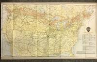
[MAPS - Canadian Pacific Railway]
Canadian Pacific Railway and Connecting Lines 1920 CPR Map
Canadian Pacific Railway 1920. First Thus. Loose Sheet. Very Good-. Poole Brothers. Map measuring 31.75 inches x 17.75 inches printed four-color. Map shows the breadth of lower Canada from just north of Vancouver Island across to Newfoundland as well as all of the United States excluding southernmost Texas and Florida. CPR lines are represented in red ink whereas connecting American railroads are in black. Black stars along the CPR indicate locations of Canadian Pacific Hotels. Two slight chips to left margin and with a couple short closed tears along folds. Please see photo. A handsome map from the tail-end of the golden age of rail travel. Now preserved in a removable clear archival sleeve. Canadian Pacific Railway unknown
书商的参考编号 : 5872
|
|
|
[MAPS - IRAQ].
Reconnaissance maps of Iraq.UK Government Survey Directorate HQ Tenth Army / Indian Field Survey Co. 1942 42 chromolithographed topographic maps of parts of Iraq made from aerial photographs during World War II on a scale of 1:100000 and 1:253440 a quarter-inch to a mile. 68 x 50.5 cm & 60 x 47 cm.
An impressive collection of Iraq maps compiled from the most current aerial photography and produced by the British Army for use in the Persian theatre of war during World War II. The cities and regions covered include ‘Ain Sifni Aqra Tel Afar Salman Pak Ba’Quba Sumaika Penjwin Halabja Baghdad Kirkuk Dulaim Erbil and Mosul divisions.Previously folded. Generally well-preserved. unknown
书商的参考编号 : L7VCIV4N38L2
|
|
|
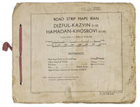
[MAPS - IRAN - WWII].
Road strip maps Iran. Dizful-Kazvin 1-10 Hamadan-Khosrovi 11-16.
83 Rep Group. I.E." 1944. Oblong 21 x 255 cm. Original beige printed paper wrappers side stichted by hand through 3 holes with a reddish pink cloth ribbon. With 1 index map and 16 numbered folding strip maps. Exceptionally rare collection of folded strip maps of roads in Western Iran which was very likely meant for military use during the Second World War. The abbreviated inscription on the front wrapper possibly stands for "24th brigade branch transportation office" though it is unknown which 24th brigade this would have been. The maps were originally printed on quarter inch sheets in 1942 and have been significantly enlarged for this edition to a scale of 1 inch to 2 miles. We have not been able to trace any other copies of either the first or second edition of this work anywhere.With an owner's inscription on the front wrapper. The maps and back wrapper have been reinforced with bookbinder's gauze. The wrappers are somewhat soiled creased and the edges are somewhat frayed. The maps have slightly browned and the index map has a small brown stain in the lower outer corner without affecting the image. Otherwise in good condition. 83 Rep Group. I.E.", hardcover
书商的参考编号 : ABC_47944
|
|
|
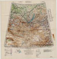
[Maps - Mongolia]
Large Color WWII Map of Mongolia
Washington D.C.: U.S. Army Army Map Service 1942. Loose sheet. Near Fine. Sheet 22 1/M North K-O 46-50. Full color map measures 28 x 29 inches. With a list of authorities i.e. other maps consulted in the creation of this map. Glossary. Index to boundaries. Folds as issued. An especially bright copy. First published 1931 by the War Office this edition is labeled "For Use by War and Navy Department Agencies Only. Not for Sale or Distribution." Revised to aid the US WWII effort in the Far East special emphasis is applied to railways international boundaries and "nomadic encampments." From the collection of Asian books and maps formed by Albert Ravenholt. U.S. Army, Army Map Service unknown
书商的参考编号 : 5330
|
|
|
[MAPS - NETHERLANDS]. [LE ROUGE, George-Louis].
La Hollande en 12 feuilles dont les six premieres contiennent la Hollande .Paris Jean A. Dezauche successor of Delisle & Buache 1790. Together ca. 230 x 155 cm. Engraved map hand-coloured in outline. Printed on 12 sheets each divided into 4 segments numbered 1-48. The 12 sheets are mounted on contemporary linen and folded the edges reinforced with blue ribbon.With: 2 LE ROUGE George Louis. Topographie de la Zelande en 9 feuilles traduitte de l'Hollandois. Second title: Partie orientale de la Flandre Hollandoise .Paris Jean A. Dezauche 1790. Large engraved wall map hand-coloured in outline printed on 9 numbered sheets each divided into 4 segments numbered 1-36 each sheet 48 x 56.5 cm; the 36 segments are mounted on contemporary linen the edges reinforced with blue ribbon. Each map in contemporary box.
Two large complementary wall maps of the seven Dutch provinces covering 1 the provinces Holland Utrecht Friesland Groningen Overijssel and Gelderland and a part of Brabant bound to the line Steenbergen - Roermond and 2 Zeeland. Both are rare especially the map of Zeeland. They were the first maps of the Netherlands on such a large scale mostly about 1:105000 but with some eastern regions squeezed in at about 1:140000. Fully assembled the map of “Hollande” would measure about 230 x 155 cm and the map of Zeeland about 143 x 175 cm.Originally published in 1748 Le Rouge's 21 plates for the two maps were revised for publication in a second state by Jean Crepy ca. 1770. The map in its present third state was revised and published by Jean A. Dezauche in 1790. On the back of each sheet is an engraved label with the sheet number and the name of the region covered added in manuscript.From the library of Marco-Antonio III 1730-1800 Prince Borghese: on each box is the engraved armorial bookplate of the library of this Borghese Prince. Marc-Antonio's son Camillo Filippo Ludovico 1775-1832 married Napoleon's sister in 1803.Boxes are slightly scuffed. A remarkable copy with a princely provenance.l De Vries 'Een Franse wandkaart van Nederland uit 1748' in: Caert-Thresoor 1 1982 pp. 24-29; cf. BMC Printed maps VIII cols. 967 & 969 1748 edition; not in Donkersloot-de Vrij; Oehme “A French world atlas” in: Imago mundi 25 1971 pp. 55-64 on Le Rouge. unknown
书商的参考编号 : 23331
|
|
|
[MAPS - POCKET]. BLEGEN, John [Johan].
Blegen’s pocket map and reference book.
Chicago: J. Blegen 1896. 12mo. 69 1 pp. With 1 large folding double-sided map “The World†on recto “United States†on verso with illustrated ads for steamship lines and Milwaukie road on recto above World map edgewear rubbing at crease folds some creasing at fore-edges couple very minor closed tears at folds. Quarter-brown cloth over beige boards decorative blue border blue lettering minor soiling edgewear still VG copy. First edition of this very scarce travel guide and pocket map issued by Blegen 1842-1927 a Norwegian-American steamship travel agent from the 1890’s into the 20th Century. His concise guidebook offered railway fares from Chicago Ocean steamship rates from New York Montreal New Orleans and San Francisco along with postage rates death mortality statistics for major American cities Brownsville TX sported 45 per 1000 while Salt Lake was 8 per 1000 coin equivalents and even a guide to sanatoriums and health spas in Europe. No physical printed copies located in Worldcat only digital or print-on-demand copies. J. Blegen, hardcover
书商的参考编号 : 59118
|
|
|
[MAPS - PORTLAND, OREGON]. BYINGTON, [Fred Fletcher] & BROWN, CA. (Cartographer). C. A.
Nonpareil indexed map of Portland Oregon. . . .
Portland OR: Published by Byington Printing Co. March 1952. 1 large folding map sized 21 x 23 printed in red & black inset map on verso of map as well as street and city guide index street traction system transportation information and zones. Map folds down into small printed portfolio w/ fold-over flap printed in red & black illust. of mill on front light toning still VG. First edition thus of this updated city map with postal zones and all of the motorcoach lines and electric trolley lines delineated. The map is of particular interest as showing Portland OR neighborhoods before the clearing and construction of Interstate-5 and the outlines of the destroyed city of Vanport. Destroyed in the 1948 flood Oregon’s second largest city had been originally constructed by Henry Kaiser outside of the Portland city limits in order to house a large influx of African-American workers largely barred by Oregon discriminatory laws. Byington 1862-1956 was a California printer who moved to Oregon following World War I would own and operate Byington Printing Co. until his death. No copies located in Worldcat. Published by Byington Printing Co., unknown
书商的参考编号 : 56432
|
|
|
[MAPS -- AUTOMOBILE & BICYCLE TRAVEL].
Wincarnis motor & cyclist map of England. Various sections. . . .
London & Norwich UK: Coleman & Co. Ltd. John Bartholomew & Co. Fletcher & Son Ltd. Litho ca. 1910. Sixteen parts. 64 pp unpaginated. double-page colour-lithograph maps throughout sized 9.5 x 7.2 when unfolded. Self-printed colour lithograph softcovers decorated title cover on front of each installment Wincarnis tonic advertisement in full colour on back cover edgewear thumbing minor chipping to a few fore-edges & corners still a G set. First edition thus of this uncommon and complete set of promotional maps for automobile travelers and bicyclists in Edwardian England whose drivers and riders were often fueled by the “delicious tonic and restorative recommended by over 8000 medical men.†The 16 maps featuring sections from London to Cornwall South Wales to Manchester and Lincolnshire to Yorkshire offered an accurate and compact set of travel maps documenting main roads secondary roads “other roads typically nearly impassable local lanes & livestock paths railways and rivers. Wincarnis was first introduced as a medicinal treatment in the Victorian era was a liqueur derived from a mix of secret herbs & spices meat extract malt extract infused with cloves nutmeg and citrus and although not openly marketed as alcoholic featured a significant 17-18% alcohol content. Therapeutic use was widely encouraged and severe motoring and bicycle accidents often included drivers and riders under the influence. Following the 1914 Parliamentary “Commission on Patent Medicines†investigation numerous changes and rules were changed regarding marketing and sales of such products as well as curtailing of hyping the “Restorative†properties. Worldcat locates 2 sets 1 undated - Hartley Library; 1 set misdated -- Wellcome; See: Drinking for Health: Proprietary Tonic Wines Chapter 10 Drinking in Victorian and Edwardian Britain: Beyond the Spectre of the Drunkard National Library of Medicine 2018. Coleman & Co., Ltd., John Bartholomew & Co., Fletcher & Son, Ltd. Litho, paperback
书商的参考编号 : 63113
|
|
|
[MAPS -- GLOBES].
The global map.
Minneapolis MN: Global Map Co. ca. 1941. Oblong folio 22.5 x 11.25 in. Two rotating wheels each showing hemisphere projection maps which are attached to a thick brown base w/ printed labels on front cover original rivets still present printed paper label and instructions on verso some rubbing & edgewear minor foxing & scuffing still a G exemplar. First edition of this fascinating and scarce global map which allows the user to view steamship or airline distance routes as well as the principal railroads. The global map was designed so that opposite halves of the earth’s surface could be rotated and synchronized enabling continuous and accurate spherical relationships across any point on the rotating maps. The label on the back lists the area in square miles and population totals of the world. The map is dated to around 1941 because of the inclusion of Vichy France the government allowed by the Nazi occupiers after the fall of France in 1940. Global Map Co., unknown
书商的参考编号 : 48041
|
|
|
[MAPS -- IRELAND]. WALKER, J.[ohn], WALKER, C.[harles], & [Alexander].
Walker’s Ireland. 15-panel dissected hand-coloured engraved map.
London: J.&C. Walker 9 Castle Street Published by Longman & Co. ca. 1844. 16mo. 3.5 x 5 in. folding out to 13.25 x 16.5 in. dissected 15-panel hand-coloured steel-engraved map linen-backed w/ 3 leaf folding population and mileage distance chart from Dublin by County mounted on front pastedown. Dark gray-green publisher’s cloth portfolio pocket binding decorative borders in blind gilt lettering stamped on front cover a NF copy. First edition thus of this very scarce dissected pocket map of Ireland published against the backdrop of the full impact of the Great Potato Famine which from 1841-1851 resulted in the diaspora and death of nearly 30% of the Irish population and as reflected in the mileage table mounted with the map the population in 1845 had already dropped from 8.2 million in 1841 to 7.7 million by 1844 and it would plummet further to below 6.5 million by 1851. The bulk of these emigrated to the United States Canada and the United Kingdom resulting in the fact that Ireland’s current population still resides below the high of 1841 and nearly 38 million Irish-Americans claim descent from the successive waves of migration much of which channeled through New York’s Lower East Side and the Bowery in the 19th-Century. John Walker 1787-1873 was a British mapmaker engraver lithographer hydrographer draughtsman and publisher publishing nautical charts and geographical maps with his brothers Charles and Alexander in their firm J.&C. Walker located at 9 Castle Street Holborn from 1841-1847 and moving to 37 Castle St. in 1848 where they remained to 1875. Much of their work was published under the auspices of the Society for the Diffusion of Useful Knowledge or S.D.U.K. Worldcat locates 1 copy Yale. J.&C. Walker, 9 Castle Street, Published by Longman & Co., hardcover
书商的参考编号 : 63111
|
|
|
[MAPS -- NEW YORK, NEW JERSEY & PENNSYLVANIA]. MacNAIR, Henry.
A survey of the Empire Group with a complete distance table a compendious index of cities and post offices with populations and much statistical data. . . .
Boston: The Bullard Co. Inc. 1909. Large folding accordion-style folded map printed in red & black sized 41 x 38 in. which when entirely folded into covers measures 5.5 x 11.25 in. Original burgundy-coloured boards small lozenge map of New York & Pennsylvania on front cover some edgewear rubbing minor tidemark to upper fore-edge of 1 corner still VG- copy. Second edition revised of this scarce and well documented map showing good roads for automobile travel railroads canals new Erie Barge Canal Steamship lines ferries lighthouses electric railway lines and more. First published in 1908 and then again in 1910 MacNair drew from US government surveys State surveys and other original commercial sources. Worldcat locates 2 copies. The Bullard Co., Inc., hardcover
书商的参考编号 : 52792
|
|
|
[MAPS -- PICTORIAL PUZZLE MAP]. WHITE, W.[illiam] F.[letcher].
Map of United States products - resources. . . No. 630.
New York: Platt & Munk Co. Inc. 1959. Oblong folio. 15 x 11 in. Approx. 75 pieces puzzle pictorial map illustration of 48 state products. Colour-illustrated box w/ label affixed on front cover announcing “Now includes Alaska the 49th State! but puzzle w/o additional image of Alaska red white & blue ribbing fore-edges minor scuffing 1 corner w/ tear & old scotch tape repair w/ former ownership marking of “Kathy†on lid still a VG copy and publisher’s ad for “Let’s Fly Away with Mother Goose†laid-in. Later printing of this surprisingly scarce pictorial map puzzle originally issued by Platt & Munk in 1932 featuring the artwork depicting Sequoia trees & fruits in California mining & sheep in Utah cattle & sheep in Montana hogs corn & wheat in Nebraska and citrus cotton oil & cattle in Texas. White 1884-1948 was an artist who trained & lived in Brooklyn NY and spent much of his later career through World War II as an instructor in fashion design and art renderings at the 5th Avenue Fashion Art Design School which preceded FIT and also featured other instructors such as Louis A. Eisele. Platt & Munk Co., Inc., unknown
书商的参考编号 : 61207
|
|
|
[MAPS -- ROME]. SICKLER, F.[riedrich] Ch.[Carl] L.[udwig].
Plan topographique de la Campagne de Rome dessine et explique. . . a l’usage des voyageurs. . . ; Plan topographique de la Campagne de Rome consideree sous le rapport de la geologie et des antiquites dessine et explique. . . ; Pantogramma ou vue descriptive generale de la Campagne de Rome dessine et explique. . . .
Rome: Venance Monaldini Librarie Place d’Espagne No. 79 1816-1821. Four works. 1st -- Large dissected copper-engraved map dissected & mounted on linen 35.5 x 22.75 in. slight foxing edgewear closed tears at corner folds a couple folds w/ archival repair tape on verso over linen; 2nd & 3rd - 8vo. 63 1; 15 1 pp. With large folding copper-engraved frontisp. highlighting section of the pantogram. Original marbled wrappers very slight chipping head & foot of spine; 4th -- large 3-sheet “Pantogram†or panoramic view of Rome 63 x 8.75 in. all preserved together in open-backed slipcase wrapped in patterned blue paper printed cover label manuscript pricing information & title in ink some scuffing & edgewear still an overall VG set. Second edition of the large dissected map of Rome and surrounding countryside fourth edition of the two-in-one handbook illustrating the coast along the Tyrrhenian Sea from Lake Bracchiano to Mount Circe and inland to the Central Apennines foothills. Sickler’s 1773-1836 Panoramic elevated view of Rome with text key above identifying churches monuments and historical locations in 19th-Century Rome together with the map and handbooks here were key references for those taking the Grand Tour following the Napoleonic Wars which had devastated much of the Continent. Pietro Ruga 1772-1850 was a noted Italian engraver printmaker furniture designer and architectural draftsman best remembered for his maps and pocket panoramic views of Rome. Venance Monaldini Librarie, Place d’Espagne, No. 79, unknown
书商的参考编号 : 60225
|
|
|
[MAPS -- SOUTH AMERICA].
The new world school map of South America. . . .
Syracuse NY: Empire New England Company Inc. ca. 1920. Double Elephant folio. 51 x 59 in. Large colour-printed map dissected and mounted on linen backing brass grommets at upper fore-edge for hanging title stamped on verso minor edgewear at creases very minor lifting at seams minor dustsoiling to outer linen when folded still a VG exemplar. First edition thus of this scarce education map of post-World War I South American geography. The map details the principal railways water routes major cities steamship routes and geographical and political details. The Empire New England Company was active in upstate New York from about 1915 until the end of the 1920s selling educational supplies maps textbooks and more. The New World School Maps could be purchased individually or in cases which held between 6-10 individual maps for school uses according to company literature of the period. Worldcat locates 1 copy Buffalo & Erie County Public Library smaller size - 1931 ed. Empire New England Company, Inc., unknown
书商的参考编号 : 52936
|
|
|
[MAPS -- WALL PULL-DOWN CASE]. ATWOOD, Wallace W.[alter] (Ed.).
Atwood Regional-Political Series seven pull-down map quarter-sawn oak wall case: Asia including U.S.S.R. in Europe; South America; Europe; United States; Africa; Australia and the Far East; North America.
Chicago IL: Published by A.J. Nystryom & Co. Maps Globes Charts 1934. Seven large linen-backed colour lithograph maps sized from 43.5 x 72 in. to 51.5 x 60 in. all mounted on their original spring-loaded rollers wooden pull dowel & metal ring pull some creasing minor edgewear creasing soot soiling to the lower margin averaging about 6-7 in. due to exposure when rolled “Europe†and “United States†with faint tidemark & discoloration at left margin some minor creasing wear all preserved in the original A.J. Nystrom quarter-sawn oak wall bracket sized 58.5 x 15.25 x 3.25 in. all pull-down maps firmly secured in their steel brackets preserving 6 of the 7 original labels on the edge of the pull-down dowels still a VG- set of maps in their original configuration. First editions thus of this complete and exceptional example of the Atwood/A.J. Nystrom Regional-Political Series Map Case reflecting the many geographical and political changes between World War I and World War II. Such changes are reflected in the appearance of Manchoukuo the Japanese controlled rump state established in Manchuria in 1932 by the Japanese Empire and also depicting Korea still as Chosen. The Europe map depicts the East Prussia still controlled by the Weimar Republic and then after Hitler ascended to power; while Africa still retains much of the colonial powers as shown in the Belgian Congo Anglo-Egyptian Sudan French Equatorial Africa and even Beuchuanaland. The Australia and the Far East Map clearly defines the Japanese United States British & Australian mandates across the South Pacific. Atwood 1872-1949 was a noted geographer and educator who was a member of both the New Jersey and Wisconsin Geological Surveys served in the US Geological Survey served as professor of Physiography at Harvard and later from 1920-1946 when he produced these maps was President of Clark University and Head of its School of Geography. No similar complete sets located in Worldcat. Published by A.J. Nystryom & Co., Maps, Globes, Charts, unknown
书商的参考编号 : 61915
|
|
|
[MAPS -- WASHINGTON & OREGON].
Sovereign Service. Swinging through the Sovereign Way “Fit for a King.†Oregon Washington.
Wichita KS & Chicago IL: Kanotex Refining Co. Derby Oil Co. Panhandle Refining Co. Eldorado Refining; Rand McNally 1940. 4to. which opens into 15 panel maps sized 19.75 x 26.5 in. map of Oregon-Washington in red & blue on verso w/ decorative borders U.S. map on recto Soverign Club information in sepia & yellow inset minor dampsoiling to 1 corner minor soiling edgewear still G copy. First edition of this scarce automobile travel map issued by the Sovereign Service gas stations and travel club on the eve of World War II for Washington & Oregon. Includes the 1940 census data within the Rand McNally issued map. No copies in Worldcat. Kanotex Refining Co., Derby Oil Co., Panhandle Refining Co., Eldorado Refining; Rand McNally, unknown
书商的参考编号 : 56581
|
|
|
[maps; French Revolution]
Maps of Sites of the War and Counter-Revolution of France 1792-1794
unknown: unknown likely early 1800s. Ephemera. Very Good. A collection of 8 engraved maps 420 x 280 mm including wide margins numbered in Arabic or Roman numerals see below otherwise seemingly uniform. From an unknown source. It includes: 1 Bombardement de Lille par l'Armee Autrichienne en 1792 with the stamp of Depot de la Guerre Bibliotheque in the top margin; 2 Siege de la Citadelle d'Anvers par l'Armee Francaise en 1792; III Siege de Valenciennes par l'Armee Coalisee Anglaise Hannovrienne et Autrichienne en 1793; VIII Siege d'Ypres par l'Armee Francaise en 1794; IX Siege de Charleroy par les Francais en 1794; X Siege de Landrecies par les Francais en 1794; XI Siege du Quesnoy par les Francaise in 1794; and XIII Siege de Nieuport par l'Armee Francaise en 1794. A bit foxed; flattened crease down the middle from folding these were perhaps pulled from a book where they were mounted on stubs along the crease. <br/><br/> [unknown] unknown
书商的参考编号 : D7401
|
|
|
[Maps]
Fiji Islands
Pacific Publications. Sydney. Loose Leaf. Very Good. Very good. 25.5 in x 19 in. Roads and towns no terrain. Two color single sided. > Language: English > Size: 19 in x 25.5 in > Media/Binding: Unbound Pacific Publications., Sydney unknown
书商的参考编号 : CORV-BBP-15797
|
|
 ?????????
 ?????PDF???
 RSS feed


