|
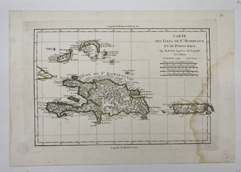
[PORTO-RICO/SAINT-DOMINGUE] BONNE (Rigobert).
Carte des Isles de St Domingue et de Porto-Rico.
Venise, (c.1790), , Mouillure sur le côté droit.
Référence libraire : 231866
|
|
|
[Pro Juventute]:
Reproductions de timbres Helvetia, 1921 à 1926.
6 cartes présentant 6 timbres de la série Helvetia, Pro Junventute, de 1921 à 1926. Format des reproductions 15 x 18 cm.
Référence libraire : 16617

|
|
|
[Proust, Marcel] George D. Painter, with illustrations, maps drawn by Samuel H. Bryant
Proust; the early years
Boston: Atlantic Monthly Press/Little Brown and Company 1959. Hardcover. xvii 435p. 8p. photos later printing cloth edgeworn dj. Atlantic Monthly Press/Little, Brown and Company hardcover
Référence libraire : 94939

|
|
|
[Ptolomaeus, Claudius]. - Sanz, Carlos
La Geographia de Ptolomeo. Ampliada con los primeros mapas impresos de América (desde 1507). Estudio bibliografico y critico. Con el catalogo de las ediciones aparecidas desde 1475 a 1883. Comentado e ilustrado.
Madrid, Victoriano Suarez, 1959. 4°. Mit zahlr. meist ganzs. Abbildungen. 281 S., 2 Bll., Lwd. d. Zt. m. goldgepr. Rückentitel u. dem eingeb. OUmschlag.
Référence libraire : 48400

|
|
|
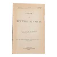
[Puerto Rico] [Maps] [Spanish-American War] Greely, Brig. Gen. A. W.
Report on Military Telegraph Lines in Porto Rico
Washington D.C.: Government Printing Office 1900. First edition. 8vo 100pp. Color folding map 42x108cm attached at rear. Stitched lacking wrappers or disbound from a larger publication paper toned with light chipping. Map clean. A good copy. <br /> <br /> Senate Document No. 429 56th congress. This report was given by Adolphus Washington Greely 1844-1935 then Brigadier General and Chief Signal Officer of the U.S. Army. Greely was in charge of maintaining communications networks during the Spanish-American War and oversaw construction and maintenance of telegraph lines in Puerto Rico Cuba and the Philippines.  <br /> <br /> The map in this report is "Map of the Island of Porto Rico Showing the lines of signal communication telegraph telephone and heliograph operated by the Signal Corps U.S. Army with Military Posts." It was prepared by major William A. Glassford under the direction of Greely.   <br /> <br /> <br /> OCLC cites 11 holdings.  . Government Printing Office unknown
Référence libraire : 6902
|
|
|
[Qatar - Bahrain - El Katif].
Hofuf. World 1,000:000. Series 1301. Edition 5-GSGS. Sheet NG39. [London], War Office and Air Ministry, 1963.
Colour-printed map, ca. 750 x 610mm. Scale: 1:1,000,000. Rare 5th GSGS edition of this map of Qatar, Bahrain, and Ras Tanura in Saudi Arabia, as part of the International Map of the World series. Depicts Saudi Arabia from As Saffaniyah in the North over Hofuf, to Hidiba in the South. Shows boundaries, highways and roads, railways, airports, rivers and water features, and other details. - Two small brown spots to the image and a nick to the top edge, some creasing near margins. OCLC 34907145.
|
|
|
[QINGDAO IN 1938].
青島市街地図. Chintao shigai chizu. Japanese Plan of Qingdao City.
Qingdao: Taiheiyoko. 太平洋行. 昭和 13 1938. Coloured folding plan of Qingdao in 1938. some browning on reverse with a small lighter section on map Japanese place names no scale 36 x 39cm 3 inset maps. This 1938 Qingdao city map shows street names in Chinese characters and location of Chinese and Japanese public buildings such as the hospital shrines Japanese primary schools and high schools. The 3 inset maps show railway and transport routes as well as outskirts of the city. . [Taiheiyoko]. 太平洋行. unknown
Référence libraire : 171093
|
|
|
[REIMS] COLIN (Jean).
Plan de la Ville Cité et Université de Reims.
Jamas, s.l., 1655 (1930-32). Grand plan divisé en 4 feuilles de 39 x 72 cm chacune. Quelques taches et une petite déchirure en marge.
Référence libraire : 14136

|
|
|
[Reinegg, Jacob]
Tabula Itineraria a Sues usque ad Dsjabbel el Mokatteb et Montem Sinai. [Bildinschrift: Báhhr el Kolsum s. Báhhr es Sues; Báhhr el Akaba]. Kupferstichkarte mit Titelkartusche, Windrose u. 2 Meilenzeigern.
Kopenhagen, André Philippe de Pretot, 1772. Blattmaß 28 x 40 cm; Bildmaß 18 x 28,5 cm.
Référence libraire : 78798
|
|
|
[ROCHAMBEAU, Jean-Baptiste Donatien, de Vimeur comte de].
I. « Plan des ville, citadelle, forts et port de Calais »; II. Cassini. Carte particulière des environs de Lille, Tournay, Valenciennes, Bouchain, Douay, Arras, Béthune. 1745.
[I. France, circa 1780]. II. Bruxelles, chez George Fricx, rue de la Madeleine, imprimeur. 1745. 1780 I: 1 feuille de 1 102 mm par 511 mm, tracée à l'encre et aquarellée ; II: 1 feuille de 420 mm par 456 mm, imprimée en noir. Les deux sont contrecollées sur toile. Cartonnage-étuis d'époque à rabats.
Référence libraire : 4944

|
|
|
[RONDEAUX DE SETRY] LOYER.
Plan de la Ville de Rouen renfermée dans sa 1ère enceinte comme elle était sous Raoul et nos premiers ducs qui l'augmentèrent beaucoup du coté du midi et ressérèrent le lit de la rivière de près d'un tiers.
s.d. (XIXème). Plan manuscrit aquarellé (41 x 26 cm), légende des lieux en marge.
Référence libraire : 13279

|
|
|
[RONDEAUX DE SETRY] RENAUD (C. R.).
Rouen au X & au XIe Siècle.
1882. Plan manuscrit aquarellé (55 x 35 cm), nombreuses annotations manuscrites reprises sur le plan original.
Référence libraire : 9933

|
|
|
[RUCHAT Abraham; THURNEYSEN Emanuel; STANYAN Abraham; ALTMANN Johann Georg:
Etat et délices de la Suisse ou Description historique et géographique des treize cantons suisses et de leurs alliés. Nouvelle édition, corrigée & considérablement augmentée par plusieurs auteurs célèbres, & enrichie de figures en taille douce & de cartes géographiques.
A Neuchâtel, chez Samuel Fauche, 1778. 2 volumes in-4 de [4]-454-[2] et [4]-388 pages, demi-basane blonde, dos lisses ornés de roulettes, filets, fleurons, titre et tomaison dorés, étiquettes de titre et tomaison rouges, tranches jaunes. Dos un peu frottés, mors du premier volume fendu en queue sur 5 cm., premières charnières faibles, un cahier très légèrement déboîté.
Référence libraire : 10246
|
|
|
[RUSSO-JAPANESE WAR - TWO NEWSPAPER MAPS].
旅順包圍攻撃圖. 日露戰爭經過圖. Ryojun hōi kōgekizu. Nichiro Sensō keikazu. Pictorial Map of Seizure of Port Arthur AND Russo-Japanese War Development Map.
大阪. Osaka.: 大阪毎日新聞社. Ōsaka Mainichi Shinbunsha. Meiji 37 1904. Two black and white newspaper maps issued in the Ōsaka Mainichi Shinbunsha one pictorial with accompanying text and adverts printed on newsprint folded. 39.5 x 55cm Very good condition. This pictorial map of Port Arthur and Dalian was published on 4 July 1904 by the Osaka Mainichi Shinbun as a supplement. It shows Port Arthur encircled by Japanese naval vessels while Dalian is depicted as being occupied by Japanese troops. On the reverse there is an essay on the war accompanied by illustrations of Russian generals and a list of wounded soldiers who had been transported to the rear.<br><br>A second map detailing developments in the Russo-Japanese War was published by the same newspaper just days later on 8 August 1904. This map provides the dates of various battles along with a chronology of the movements of the Russian Vladivostok fleet and Japanese attacks on Port Arthur. These two maps are rare examples of the kind of information made available to the general public on a day-to-day basis during the war. . 大阪毎日新聞社. [Ōsaka Mainichi Shinbunsha]. unknown
Référence libraire : 216797
|
|
|
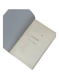
[Sahara Maps] [Algiers] Sabatier, Camille
La Question du Sud-Ouest
Algiers: Adolphe Jourdan Libraire-Editeur 1881. First edition. 22x14cm vi 70 2. Large folding map "Carte du Sahara Central par M. Camille Sabatier" and table of contents at rear. Stitched in gray laid paper wraps. Single pencil annotation on pg. 47 else clean internally and nearly fine. <br /> <br /> Scarce French Algerian text by Camille Sabatier 1851-1919 lawyer and politician who wrote extensively on the geography and politics of the Sahara region. Sabatier was French deputy in Algeria from 1885-1889. He was a member of the geographical societies of Oran and Algiers and prepared the map in this text with the assistance of French cartographer Justin Pouyanne.<br /> <br /> The work focuses on the local tribes of the Sahara region including Hamyan Trafi Laghouati Chambaa Ait-Atta Arib and Doui-Menia their interactions religions etc. The text also details trade routes geography and climate of the region arguing the ignorance of seeing the Sahara as just "a sea of sands" leads to political surprise and disaster.  <br /> <br /> OCLC cites 6 holdings 4 of them in France.  <br /> <br /> <br /> . Adolphe Jourdan, Libraire-Editeur unknown
Référence libraire : 9118
|
|
|
[SAINTE-HÉLÈNE] READ (R. P.).
The Geographical plan of the island & forts of Saint Helena.
[London, Burgis & Barfoot], (1841) 42 x 56 cm, encadrée sous verre (encadrement postérieure). Pliure centrale.
Référence libraire : 244229
|
|
|
[sans auteur] - RIQUETTI [ou RIQUETI] (Victor, Comte de MIRABEAU).
Atlas de la monarchie prussienne [sous Frédéric le Grand].
A Londres, s.é. [Lejay], 1788. Un fort vol. au format in-folio (433 x 277 mm) de 3 ff. n.fol., [10] cartes gravées sur double-page,, 93 planches gravées + tableaux et 1 f. bl. Ne subsiste plus de la reliure que le carton des plats.
Référence libraire : 26048

|
|
|
[sans auteur].
Petit atlas national des 86 départements de la France et de ses colonies.
(Paris), Blaisot, 1835. Un fort vol. au format pt in-4 (263 x 182 mm) de 1 titre-frontispice n.fol. et [99] planches gravées sur double-page. Reliure de l'époque d edemi-basane glacée sapin, dos lisse orné de doubles filets dorés, larges fleurons romantiques dorés, titre doré.
Référence libraire : 26317

|
|
|
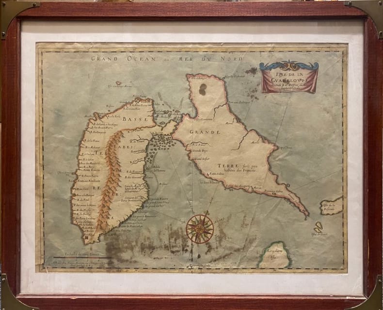
[SANSON D'ABBEVILLE (Nicolas)].
Isle de la Guadeloupe. Scituée à 16 degrez de Lat .Septentrionale. A Paris chez Pierre Mariette, rue S.Iacques à L'Espérance. Avec Privilège du Roy
Paris, MARIETTE Pierre, (vers 1662) à vue : 32 x 43,5 cm - cadre : 43 x 52.5 cm , Cadre du XXe siècle. Déchirures dont une au coin inférieur gauche et une au niveau inférieur de la pliure centrale. Taches.
Référence libraire : 230537
|
|
|
[Saudi Arabia and Yemen].
Collection of USAF Aeronautical Charts. Washington, DC, Army Map Service, 1942 and 1944.
8 charts. 560 x 735 mm, with key printed on the back. Scale 1:1,000,000. Substantial set of first edition U.S. pilot charts from the Second World War. Includes 2 maps of the Arabian Peninsula (668 and 669), depicting the border region of Saudi Arabia, Yemen and the Aden Protectorate and covering the area between the 42nd and 54th meridian east, and between the 16th and 20th parallel north. Also shows the Frasan Islands as well as large parts of the Rub' al Kahli desert with sections marked "unexplored", the city of Salala constituting the easternmost point. - Further, two maps of Iran (429 and 443) between the 53rd and 60th meridian east, and the 28th and 36th parallel north, identifying Kerman, Yazd and Birjand. - The remaining maps cover western Afghanistan (439), labelling Herat and Farah, central India (559), with cities such as Jabalpur, Bhopal and Achalpur, and the Indian Ocean showing the Chagos archipelago (1037) and Comoro Island (1052). - Chart no. 1037 dampstained with loss to the centre, chart no. 669 lacks approx. 5.5 cm, clipped away at upper margin. Remaining maps with occasional small tears, but overall in good condition.
|
|
|
[Saudi Arabia].
Abl Ghamghimah. Series K 502, Sheet NE 39-4, Edition 1-AMS. Washington, D.C., Army Map Service, 1965.
Folding map. Ca. 755 x 570 mm. Scale 1:250,000. Military geological map of 'Abl Ghamghimah in the Eastern Province of Saudi Arabia. Prepared by the U.S. Army after aerial photography in December 1954 and January/February 1955. Reprinted for the UK Ministry of Defence with their stamp: "Limited distribution. U.K. officials are not to release the map outside government service". The chart details the average relative heights of sand dunes as well as sabkhas and water wells. - Occasional light browning.
|
|
|
[Saudi Arabia].
Al Jauf H-37. Potsdam, Ministerium für nationale Verteidigung, 1965/1966.
645 x 590 mm. Scale 1:1,000,000. Topographical map covering the northern part of Saudi Arabia around the town of Jawf (Jauf) and Wadi Sirhan. It shows international boundary, populated places, roads and tracks, railways, wireless telegraph stations, forts, wadis, wells, vegetation and terrain features. Shows also parts of Transjordan and Iraq. Relief shown by hachures, spot heights and gradient tints. - A few brown spots near upper left corner. Very well preserved.
|
|
|
[Scherz, C. F.]
Die Nordsee-Insel Borkum. Nebst ärztlichen Ratschlägen und Winken, betreffend die Seereise, den Aufenthalt auf der Insel und den Gebrauch des Seebades. 10. vermehrte u. verbesserte Aufl.
Emden u. Borkum, W. Haynel, [ 1901]. VIII, 286 S., 22 AnzeigenS. Mit 119 Abb. u. Illustr. im Text u. 1 farbig lithograph., mehrfach gefalt. Plan. 19,5 cm. Farbig illustr. OLn.
Référence libraire : 98304

|
|
|
[Scherz, C. F.]
Die Nordsee-Insel Borkum. Nebst ärztlichen Ratschlägen und Winken, betreffend die Seereise, den Aufenthalt auf der Insel und den Gebrauch des Seebades. 10. vermehrte u. verbesserte Aufl.
Emden u. Borkum, W. Haynel, [ 1901]. VIII, 286 S., 22 AnzeigenS. Mit 119 Abb. u. Illustr. im Text u. 1 farbig lithograph., mehrfach gefalt. Plan. 19,5 cm. Farbig illustr. OLn.
Référence libraire : 98954
|
|
|
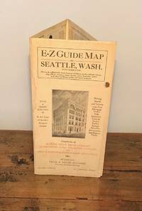
[Seattle - Maps]
E-Z Guide Map of Seattle Wash. With Indicator
Seattle: Seattle Title Trust Company 1926. First Printing. Very Good. Narrow octavo. Six panel fold-out map printed in black and orange with titles and illustration on front panel. A touch of sunning and two light dampstains on two exterior folds non-map side. Now housed in a clear archival sleeve with an acid-free backing. [Seattle Title Trust Company] unknown
Référence libraire : 11632
|
|
|
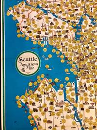
[SEATTLE - Maps]
Scarce Pictorial Map of Seattle - "Seattle Awareness Map
Seattle: City of Seattle 1978. First Printing. Very Good. Anne W. Knight. Single sheet measuring 26.25" x 44.5" 67 x 113 cm folds to 7" x 11" 17 x 28 cm. Color map depicts Seattle's hourglass shape bordered on the west by Lake Washington to the east by Puget Sound. Reverse features a narrative timeline of the city along with historic photos and a key to points of interest. Slight age toning to the folded front and rear covers and some pinholes at intersections of folds. <p>Historical and cultural facets of Seattle are emphasized through idiosyncratic 1970s design excess using cartoon thought-bubbles for commentary. Produced by the city's Department of Community Development under Mayor Charles Royer the map reveals the mores of 1970s culture. For example the map features Seattle City Light's "Solar Powered Home" and "Experimental Wind Generator" harbingers of today's reality along with landmarks some obscure of the city's history. OCLC locates two copies one at the Seattle Public Library the other at the University of Washington.</p> . City of Seattle unknown
Référence libraire : 2072
|
|
|
[SEINE-ET-MARNE]
Carte de la Forêt de Fontainebleau. avec un plan de la ville à l'usage des promeneurs, des cyclistes et des automobilistes
Paris, A. Taride, s.d. in-8, broché. Petite mouillure à la couv.
Référence libraire : 188829
|
|
|
[SERIZAWA KEIGO]. 芹澤馨吾
標準大東亞分圖・南洋群島 内南洋. Hyojun Daito-A bunzu: Nanyo gunto nai Nanyo. Standard Sectional Map of the Greater East Asia: the South Sea Islands Inner South Sea.
統正社 Tōseisha . Showa 18 1943. Colour folded map 54. x 76.5cm. Pinholes at corners light even browning good copy. This Japanese map of Micronesia shows the Mariana Islands Eastern and Western Caroline Islands Marshall Islands and Gilbert Islands. The separate maps around the edge are clockwise from the upper right corner: Jaluit Atoll Guam Island Rota Island Saipan Island Palau Islands Yap Island Hall Islands Pohnpei Island Truk Islands and Kusaie Island. . 統正社 [Tōseisha ]. unknown
Référence libraire : 155215
|
|
|
[SERVICE HYDROGRAPHIQUE DE LA MARINE] BOUQUET DE LA GRYE - INGENIEUR HYDROGRAPHE
CÔTE OCCIDENTALE DE FRANCE : COURS DE LA LOIRE DEPUIS NANTES JUSQU'A SON EMBOUCHURE - 1891 -
Nantes SERVICE HYDROGRAPHIQUE DE LA MARINE 1891 in-8 une carte dépliante entoilée in-octavo, format plié : (24 x 16 cm), plats cartonnés recouvert de percaline bleu-marine, N° 4321 frappé "or" au centre du dos (N° de référence de la carte en bas à droite de la gravure ), divisée en 21 panneaux, format déplié : 105 centimètres de large par 68,5 centimètres de haut, Carte gravée par Emile DELANNE, 1891 Paris SERVICE HYDROGRAPHIQUE DE LA MARINE Editeur ,
Référence libraire : 22306
|
|
|
[Shell]
CARTE REGIONALE SHELL N° 1 "NORD - BELGIQUE"
Carte géographique, format ouvert 910 x 660 mm, éditée en 1940, bon état
Référence libraire : LFA-126737263
|
|
|
[SHIHAN GAKKŌ] 師範学校編輯.
北亜米利加洲. Kita Amerika-shū. The States of North America.
Kyoto.: 村上勘兵衛 文部省刊行. Murakami Kanbē; Monbushō kankō. Meiji 10 1877. Colour woodblock map of North and Central America. From the Journal of World Geography 萬國地誌略 published in 1877. Printed area measures 33.5 x 21cm a good copy with occasional soiling. . 村上勘兵衛, 文部省刊行. [Murakami Kanbē; Monbushō kanko& unknown
Référence libraire : 159812
|
|
|
[SHIPPING -- MAPS]. ROWAN, JF. (Exec. Secretary). J. F.
Household Goods Carriers’ Bureau agent mileage guide No. 4. Cancels mileage guide No. 3. Containing maps and charts of distances in miles for common contract and passenger carriers between points within the United States also. . . to and from points in Canada and Mexico. . . ; Supplement No. 10. . . cancels Supplement No. 9. . . Effective June 7 1947.
Washington D.C. & Chicago IL: Household Goods Carriers’ Bureau Rand McNally & Co. 1941; 1947. Two vols. 296 pp. including 22 large folding colour maps a few w/ minor toning to fore-edges some dustsoiling a few w/ minor tape repairs especially at a couple folds and near gutter margin. Quarter-green cloth over printed light green softcovers stapled as issued minor soiling some slight foxing & toning still VG copy; 9 3 pp. Stapled as issued minor toning light creasing at corners VG. First edition of this essential HHGCB mileage guide issued just weeks before Pearl Harbor and the entry of the United States into World War II. Originally established in 1936 after the passage of the Reed-Bulwinkle and Interstate Commerce Commission Acts the HHGCB organized to file the required mileage tariffs with the ICC and issued this guidebook. This mileage guide contained maps from the Rand McNally Co. together with charts to determine highway distances between principal points in the United States and allow transport charges to be computed. This guidebook offers an essential snapshot of not only the existing transportation network during World War II but also the vital routes of trucking goods across the country locally or into Canada and Mexico prior to the creation of the Interstate Highway System later authorized in 1956 by President Eisenhower. The supplement updated many of the mileage references following the War acknowledging the tremendous build-up of infrastructure during and in Post-War America. The HHGCB continued to operate in assorted consolidations and mergers until the 2007 decision eliminating all motor carrier rate bureaus. Worldcat locates 1 copy of No. 4 no copies located of Supplement No. 10 US Dept. of Transportation Library. Household Goods Carriers’ Bureau, Rand McNally & Co., paperback
Référence libraire : 56936
|
|
|
[Siebenbürgen] - Tîrgu Mures.
Libera regiaque civitas siculica Maros Vasarhely. Targu Mures, [1822-]1827.
Kupferstich von Samuel Nagy nach Mikolai Tóth Istvan. 415:780 mm. Unter Passepartout. Prachtvolle und großformatige, als Einzelblatt erschienene Gesamtansicht der Stadt Targu Mures (dt. Neumarkt am Mieresch, ungar. Marosvásárhely) in Siebenbürgen. - Bei der in den Jahren 1822-25 entstandenen Ansicht der Stadt aus der Vogelschau handelt es sich um die bis dahin genaueste topographische Aufnahme der Stadt, die bis zum Beginn des 20. Jahrhunderts unübertroffen bleiben sollte. Vorangegangen waren dem vorliegenden Blatt lediglich zwei kleinere und recht ungenaue Veduten von 1736 bzw. 1750; die früheste bei Nebehay/Wagner genannte Ansicht der Stadt datiert überhaupt erst von 1840. Die eingedruckte Legende im unteren weißen Rand benennt die wichtigsten Gebäude und Monumente, dazwischen ein Adler das Stadtwappen haltend. - Breitrandig mit umlaufendem Plattenrand und sehr sauber. Minimale Randläsuren außerhalb des Passepartoutausschnittes fachmännisch restauriert. Von größter Seltenheit. Keresztes Gyula. Marosvásárhely látképe és házsorainak képe Mikolai Tóth István rajzai alapján, Milléniumi megemlékezés, Juventus Kiadó, Marosvásárhely, 2000, SS. 230-237.

|
|
|
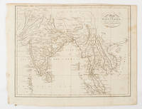
[SOUTH ASIA - MAP]. NEELE, SAMUEL JOHN.
Map of the East Indies from the Best Authorities.
London & Glasgow.: W. and D. Brownlie. 1805. Engraved map 18.7 x 23.9 cm original folds age toned and spotted inner margin a trifle ragged paper thinning in a few spots in good condition. Attractive map engraved for "A System of Geography; or A Descriptive Historical and Philosophical View of the Several Quarters of the World" published in 1805. . (W. and D. Brownlie) unknown
Référence libraire : 175148
|
|
|
[Southern Palestine].
Seetzens Entwurf einer Original Charte von Dschebal (Gebalene) und Scharah- (Seir-) Gebirge. Nach mündlichen Nachrichten [...] mit Hinzufügung der alten Namen von Fr. Kruse. [Berlin, G. Reimer, 1859].
Lithographed map, single sheet. 455 x 560 mm (image size), 516 x 645 mm (sheet size). Scarce lithographed map of southern Palestine showing the travel route of the German orientalist Ulrich Jasper Seetzen (1767-1811), designating landmarks like Petra and Saint Catherine's Monastery on the Sinai Peninsula, as well as geological features. The main map shows Seetzen's itinerary from the Be'er Sheva area to its intersection with the Egyptian caravan road from Mecca to Cairo, flanked in the east by Al-Sharah mountains and the Gebalene region. An inset depicts the continuation of the route from there to Mount Sinai, while another contains a detailed plan of the mountain. Features comments on soil fertility as well as labels of notable settlements, mountains, streams, and wall remains encountered along the route. - Prepared by A. Bräunig, the map was issued as plate 3 in the fourth volume of Seetzen's posthumous travelogue series "Reisen durch Syrien, Palästina, Phönicien, die Transjordan-Länder, Arabia Petraea und Unter-Aegypten", published from 1855 to 1859. - Very well preserved. OCLC 5061964.
|
|
|
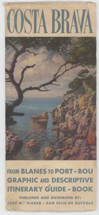
[Spain]; [Maps]
Costa Brava from Blanes to Port-Bou: Graphic and Descriptive Itinerary Guide-Book
San Feliu de Guixols: Jose M. Viader 1950. Wraps. Very Good. 26.5 cm x 11.5 cm. Map. White wraps with the front wrapper illustrated in color and printed in blue the rear wrapper and the interior of each wrapper printed in black. A color map housed in the wrappers six folds map in the concertina style. A small essay on Costa Brava printed in black on the verso of the map. Wear and a few tiny tears to the wrappers' edges. Jose M. Viader unknown
Référence libraire : 000015406
|
|
|
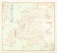
[SURVEYING BUREAU OF THE PEOPLE'S LIBERATION ARMY GENERAL STAFF DEPARTMENT]. 总参谋部测绘局.
抗震救灾专用地图: 四川省全图./汶川县及周边地势图. Sichuan sheng quan tu./Wenchuan xian ji zhou bian di shi tu. Special Maps for Earthquake Disaster Relief: Map of Sichuan Province./ Map of Wencuan County and Its Vicinity.
北京.Beijing.: 星球地图出版社.Xing qiu di tu chu ban she. May2008. Two large coloured maps printed on double sided on a single sheet folded issued shortly after the devastating 2008 Wenchuan Earthquake which was occurred on 12 May 2008. Small tears along folds mended by both non-acidic tape and cello tape some creasing generally good. Text in Chinese. Sheet measures 84.9 x 119.7cm. <br> <br>Map of Sichuan Province: scale 1: 1100000 inset map lower right corner showing the provincial capital city Chengdu a statistical chart lower section listing counties within Sichuan Province their population and territory size. <br> <br>Map of Wenchuan County and Its Vicinity: 1: 300000 various colour representing altitude differences inset map showing the position Wenchuan County within Sichuan Province a mileage chart listing the distance between Wenchuan County to nearby cities. A brief introduction of Wenchuan on left section accompanying the images of the rescue forces. The Great Wenchuan Earthquake was the biggest earthquake in Chinese history with a casualty over 69000 people. . 星球地图出版社.[Xing qiu di tu chu ban she]. unknown
Référence libraire : 169215

|
|
|
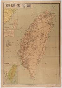
[TAIWAN PROVINCE MAP].
台灣省地圖. Taiwansheng ditu. Map of Taiwan Province.
地圖出版社. Reprint. 1954. Colour folding map of Taiwan showing all major cities towns and villages railways highways roads rivers and sea routes. Topographical inset map at lower left Taiwan Straits with mainland coast inset map at top left. Each map has its own scale. Text in traditional Chinese characters. Washi repairs along some folds on reverse pin marks at corners evenly browned and a little faded. A nice map of Taiwan in fair condition. 77 x 53.8cm. . 地圖出版社. unknown
Référence libraire : 215869
|
|
|
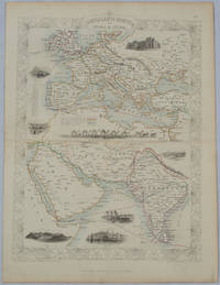
[TALLIS, JOHN], RAPKIN, J., WARREN H., AND KERNOT JH. J. H.
Overland Route to India and China
London.: The London Printing and Publishing Company. circa1850s. Lithographed map with original outline hand colour 33 x 24.5 cm including border and captions seven vignette illustrations two reference keys decorative border central fold light toning mainly at the central fold and to the verso of the sheet in very good condition preserved in a window mount. Attractive decorative map with fine vignettes of the London Post Office Suez Bombay Madras. Aden Malta Gibraltar and a wonderful camel train led by a carriage and horses crossing North Africa originally by the great mapmaker and publisher John Tallis. The two reference keys note steam packet routes railways electric telegraph and the Suez Canal. . The London Printing and Publishing Company. unknown
Référence libraire : 177525
|
|
|
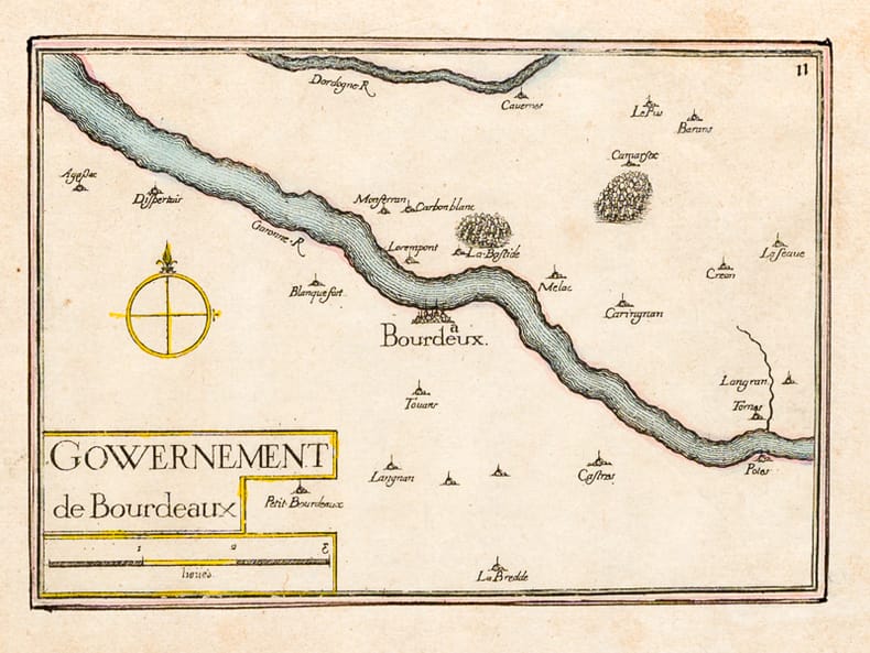
[TASSIN, Nicolas ; TASSIN, Christophe ]
Gouvernement de Bourdeaux [ Carte du Gouvernement de Bordeaux ] [ Edition originale ]
1 carte rehaussée en couleurs sous cadre vitré format 22 x 18,5 cm, gravure format (à vue) 19,5 x 14,5 cm, s.d. [ circa 1634 ]
Référence libraire : 62936
|
|
|
[Texas Maps]: Lapie, M.
CARTE DE L'AMERIQUE SEPTENTRIONALE
Paris 1842. Partially colored map 27 x 20 inches. Center fold some foxing else very nice. Archival matting and protected with Mylar sheet. Shows all of North America with Russian British U.S. and Mexican possessions. Texas is shown as part of the United States with the Nueces as the boundary line with Mexico. unknown
Référence libraire : WRCAM9643

|
|
|
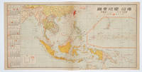
[THE ASAHI SHIMBUN]. 朝日新聞社.
佛印・蘭印要圖. 朝日カレンダー・ニユース地圖版. Futsu-In Ran-In Yozu. Asahi Karenda Nyusu Chizuban. Detailed Map of Southeast Asia. Daily Calendar News Version.
No place of publication.: 朝日新聞社. The Asahi Shimbun. 昭和十五1940. Published by 朝日新聞社 The Asahi Shimbun Japanese folding coloured WWII map with a calendar from January to June Shōwa 15 at the left scale 1:300000. Map includes French Indochina Dutch East Indies and parts of the territory of Papua China and British India. Some light browning and foxing otherwise very good. Text in Japanese. 25.3 x 51cm. Legend at lower left lists the boundaries between continents countries and provincials or regions railways airline routes capitals and Japanese embassies and consulates. <br> <br>The natural resources are indicated across the map. The map also shows parts of the territory of Papua under Australia's administration " 濠洲委任統治領 Gōshū inin tōchiryō". . 朝日新聞社. [The Asahi Shimbun]. unknown
Référence libraire : 160545
|
|
|
[Timbres Magazine]
TIMBRES MAGAZINE - L'OFFICIEL DE LA PHILATELIE n° 99 (Mars 2009)
Revue mensuelle concernant la philatélie : environ 110 pages en couleurs, format 300 x 210 mm, illustrée, brochée couverture couleurs + fiches détachables
Référence libraire : LFA01da2
|
|
|
[Timbres Magazine]
TIMBRES MAGAZINE - L'OFFICIEL DE LA PHILATELIE n°60 (Septembre 2005)
Revue mensuelle concernant la philatélie : environ 110 pages en couleurs, format 300 x 210 mm, illustrée, brochée couverture couleurs + fiches détachables
Référence libraire : LFA01804
|
|
|
[Timbres]:
4 timbres Helvetia / Pro Juventute.
La Chaux-de-Fonds, Courvoisier, 1957. Ravissante petite plaquette de 4 pages et 2 serpentes, brochée sur cordon et au coeur de laquelle se nichent 4 timbres (non obliétérés) de 1957.
Référence libraire : 16628
|
|
|
[TOKYO - ANTIQUE PRINT] VAN DER AA, PIERRE.
Iedo. Capitale du Japon.
A Leide. Leiden.: Chez Pierre van der Aa. circa1720. Engraved panorama on watermarked laid paper 28.5 x 77.5 including captions; 31 x 79.5 cm sheet title cartouche engraved key in French and Dutch the upper margin trimmed to the platemark original folds edgewear and toning neat sealed tear to the outer edge barely visible 5mm intrusion to the image a very good dark impression. Finely composed and engraved panorama of Tokyo prepared for the monumental work "Galerie Agreable du Monde" by the master Dutch publisher Pieter Van de Aa 1659-1733. The detailed key in Dutch and French notes myriad buildings and temples on the horizon and in the foreground two processions converge: of nobles and their attendants dancers a trio of dogs and a priest or religious attending a suppliant. <br> <br>Pieter van der Aa 1659-1733 was born in Leiden Holland and started his own book publishing business when he was only twenty-three. His prolific output of highly decorated maps and atlases culminated in his magnum opus “Galerie Agreable du Monde” which illustrated the world known to Europeans in the early eighteenth century. Comprising 66 volumes it was the of plates published at that time it has been estimated that only 100 copies were published. . Chez Pierre van der Aa unknown
Référence libraire : 180201
|
|
|
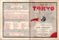
[TOKYO - TOURIST MAP] KING ASSOCIATES.
Bilingual Map of Greater Tokyo.
Tokyo.: Charles E. Tuttle Company. 1954. Printed four colour map 92 x 71cm; 102.5 x 74.5cm sheet folding into pictorial wrappers 25.6 x 19 cms inset map of the Marounouchi District and on the verso an extensive grid reference in English and Japanese and over four panels a map of the streetcar railway and subway system scant spotting to cover two small fold splits without loss and toning most evident at the folds in very good condition. Comprehensive 1950s map of Tokyo by US publisher Charles E. Tuttle "Here at last is the map that makes order out of chaos.extending as far as Haneda Airport Grant Hights Harbor Area and Nakano Ward" blurb. . Charles E. Tuttle Company. unknown
Référence libraire : 194113
|
|
|
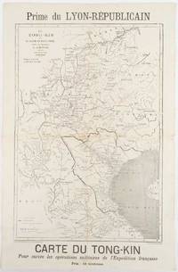
[TONKIN CAMPAIGN - MAP] MEYNIARD, CHARLES; HAUSERMANN, R. (ENGRAVER)
Le Tong-Kin et le Bassin du Fleuve Rouge d'Apres les Documents de J. Dupuis
Lyon.: Lyon-Républicain. circa1883. Engraved map 40.5 x 27.5; 48.9 x 31.8 cm sheet original folds some browning to the fold and margins two small holes at the central fold without significant loss in good condition. Map issued as a supplement to "Le Lyon-Republicain" one of the great radical daily newspapers in Lyon. The map is after documents by French explorer and trader Jean Dupuis 1829-1912 who had explored regions along the Red River in the hopes of establishing trade routes within Vietnam and China and variously published. This supplement was issued on the eve of the Tonkin War in 1883 so that readers could follow the military movements of the French Expeditionary Force. It shows northern Vietnam and into south-western China with provinces marked and river systems in detail. . Lyon-Républicain. unknown
Référence libraire : 180621
|
|
|
[TOULON]
Plan de la ville de Toulon indiquant les agrandissements au nord et à l'ouest.
Toulon, Rumèbe, s.d. (c. 1860) 48 x 56, replié au format in-12, sous couverture imprimée. Déchirure à la couverture.
Référence libraire : 218540
|
|
|
[TOURIST MAP OF HANGZHOU].
杭州游覽图. Hangzhou you lan tu. Tourist Map of Hangzhou.
杭州.Hangzhou.: 浙江人民出版社.Zhejiang renmin chu ban she. 2nd Edition 3rd Printing. 1962. Folding colour tourist brochure for Hangzhou. One side shows large map of Hangzhou the other 5 more detailed maps chops and previous owner's annotations upper cover small hole at one fold some light wear and browning good. Text in both traditional and simplified Chinese. Sheet size 53.9 x 38.3cm folded size 13.5 x 19.2cm. <br> <br>One side includes a legend an inset showing tourist spots surrounding Hangzhou a table shows lists of Hangzhou's hospitality industry e.g. hotels cinemas swimming pools restaurants department stores etc. The other side includes five individual tourist maps: Viewing Fish at Flower Pond 花港觀魚 Lingyin Temple 靈隱 Hangzhou Bus Map 杭州市公交路线图 Lonely Mountain 孤山 Dreaming of the Tiger Spring 虎跑. . 浙江人民出版社.[Zhejiang renmin chu ban she]. unknown
Référence libraire : 160933
|
|
 Recevoir par e-mail
 Télécharger en PDF
 Flux RSS


