|
PIRANESI Giovan Battista (Mogliano Veneto 1720 - Roma 1778)
Pianta di Roma e del Campo Marzo
La Pianta di Roma e del Campo Marzio appartiene al culmine della carriera del Piranesi.Nata dalla necessità di offrire una pianta di riferimento che accompagnasse le 135 tavole delle Vedute di Roma, l'opera fu intesa come tavola finale e indice dell'opera, con con cui veniva spesso venduta e rilegata. Attraverso le tre lastre che compongono questa grande piante, l'autore ha cercato di mettere in relazione le rovine superstiti di epoca antica con la contemporanea topografia di Roma, e di offrire dei riferimenti per i monumenti elencati ai due lati della mappa. Nella parte superiore ha realizzato una mappa della città contemporanea compresa entro le Mura Aureliane, estendendola a nord, a includere il territorio tra Porta del Popolo e Ponte Milvio, e inglobando anche l'area del Campo Marzio.Quest'area è mostrata nel dettaglio in una mappa isolata, in basso a destra, che mostra le antichità più importanti evidenziate da un numero che trova corrispondenza con quelli della mappa più grande. Ai lati, un indice dettagliato dei monumenti, con i numeri corrispondenti nella pianta grande, e con i rimandi ai passaggi più rilevanti delle sue opere maggiori: le Antichità Romane, Della Magnificenza ed Archittettura dei Romani e il Campo Marzio. L'opera è dedicata a papa Clemente XIV (1769-1774).La datazione dell'opera è complessa: - nel catalogo del 1792 di Francesco Piranesi, figlio dell'autore, l'opera è assegnata al 1778, data che, sebbene molto tarda - l'autore muore infatti il 9 novembre di quell'anno - viene accettata da Focillon e Hind. Questa datazione, tuttavia, è certamente basata su un errore, poiché nell'Avvertimento nella parte superiore della mappa, l'autore fa riferimento alla "approvazione che si è degnata mostrarne la Santità di N.ro Sig.re PAPA CLEMENTE XIV felicemente regnante", per cui l'opera non può essere successiva al 1774.A supporto di questa datazione, è un esemplare del Catalogo delle Opere, descritto da Scott, che contiene tre voci manoscritte per tre Vedute di Roma databili al 1774, e indica che la mappa era già disponibile.Esemplare dalla contemporanea edizione romana.Acquaforte e bulino, stampata da tre matrici su tre fogli carta vergata coeva uniti insieme, con filigrana "doppio cerchio e giglio", in ottimo stato di conservazione.Dimensione complessiva dei tre fogli: 132.1 x 82.1 cm Dimensioni complessive delle lastre: 121.2 x 71.1 cm Map of Rome and the Campus Martius, formed by three plates and usually found in association with the Vedute di Roma. He may have felt the need for a reference map to accompany collections of these plates and devised this work to fill this need. Exercising his skills in presenting formidable quantities of information coherently, he sought to relate the surviving remains of antiquity to the contemporary topography of Rome and to offer an easy reference to published information about them. He therefore produced a large map of the modern city within the Aurelian Walls, together with an extension showing the territory to the north, between Porta del Popolo and Ponte Milvio and including the Campus Martius area.This is augmented by a smaller map isolating the principal antiquities, which were marked with numbers correspondending to those in the larger map. Around these Piranesi arranged a detailed index listing the monuments according to their assigned numbers and referring to relevant passages in his major pubblications, including the Antichità Romane, Della Magnificenza ed Archittettura dei Romani and Campo Marzio.The dating of the map is problematic, since, although it is dedicated to Clemente XIV (1769-1774), Francesco Piranesi's 1792 cataloghe assigns is to 1778 and most authorities, including Giesecke, Focillon and Hind, have accepted a late, if not posthumous date; however this date is certainly based on error, since Giambattista, in his Avvertimento at the top of the main map, refers to "l'approvazione che si è degnata mostrarne la Santità di N.ro Sig.re PAPA CLEMENTE XIV felicemente regnante". Supporting evidence for an earlier date comes from an impression of the Catalogo delle Opere, referred to by Scott, which contains manuscript entries for the three Vedute di Roma datable to 1774 and indicates that the map was already available. Etching, printed from the plates on three sheets of contemporary laid paper with watermark, double circle with the fleurs-de-lys.A very good early impression for the contemporary roman edition. Hind, p. 87, [1778-9.]; Focillon 600; Ficacci 700; Wilton-Ely, II, 1008.

|
|
|
PIRANESI Giovan Battista (Mogliano Veneto 1720 - Roma 1778)
Tavola Topografica di Roma in cui si dimostrano gli andamenti degli Antichi Acquedotti…
Bella tavola topografica di Roma che riporta il tracciato degli antichi acquedotti romani. Il contenuto della tavola è dichiarato in alto a sinitra: "Dichiarazione delle note della Tavola: A. Mura odierne di Roma B. Mura di Roma anteriori all'Imperatore Aureliano Aquedotto arcuato della Marcia, Tepula, e Giulia Aquedotto arcuato della Claudia e Anione Nuovo Archi Neroniani Archi Antoniniani Aquedotto sostruito Aquedotto sotterraneo Rivo sotterraneo, porzionario delle acque Circonferenza delle Regioni antiche di Roma Nota delle Vie antiche Le rimanenti note son dichiarate o nella Tavola, o nella Spiegazione consecutiva della medesima Piedi Antichi Romani"Le tre "figure" sono disegni tecnici che rappresentano le sezioni e il funzionamento degli antichi acquedotti. La tavola è la n. XXXVIII del tomo I delle Antichità Romane, prima edizione del 1756 edita da Bouchard e Gravier. Meravigliosa prova, ricca di toni, impressa a inchiostro bruno su carta vergata coeva con la tipica filigrana del “doppio cerchio e giglio con lettere CB” (Robison 33), con pieni margini, in ottimo stato di conservazione. A topographical map of Rome depicting the paths of the ancient aqueducts. The inscription "Dichiarazione delle note della Tavola", explains the contents that include named walls of Rome and subterranean aqueducts as well as identifying footprints of ancient remains."Dichiarazione delle note della Tavola: A. Mura odierne di Roma B. Mura di Roma anteriori all'Imperatore Aureliano Aquedotto arcuato della Marcia, Tepula, e Giulia Aquedotto arcuato della Claudia e Anione Nuovo Archi Neroniani Archi Antoniniani Aquedotto sostruito Aquedotto sotterraneo Rivo sotterraneo, porzionario delle acque Circonferenza delle Regioni antiche di Roma Nota delle Vie antiche Le rimanenti note son dichiarate o nella Tavola, o nella Spiegazione consecutiva della medesima Piedi Antichi Romani "Inset are technical drawings of aqueduct mechanisms. This is the plate XXXVIII of tome I of Antichità Romane, first edition by the French publisher Bouchard and Gravier in 1756. A great impression, printed with brown ink on contemporary laid, strong, paper with “double encircled fleur-de-lys with letter CB” watermark (Robison 33), with margins, perfect conditions. Wilton-Ely, 352; Focillon 217

|
|
|
PIRINEOS.
Pirineos. Revista del Instituto de Estudios Pirenaicos. Números 28-29-30. [Jesús Elosegui Irazusta: Catálogo dolménico del País Vasco; Pedro Montserrat: El Turbón y su flora; Ramón Margalef: Algunos organismos interesantes de las aguas dulces de los Pirineos, y otros textos].
Zaragoza, CSIC, 1953. 4to.; 355 pp. Ilustraciones entre el texto, 18 láminas fotográficas y un gran mapa plegado "Mapa de la situación de 340 dólmenes y túmulos descritos en el "Catálogo dolménico del País Vasco"". Cubiertas originales.

|
|
|
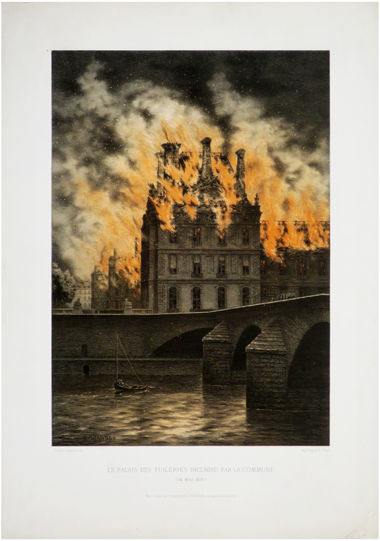
PIRODON (Eugène Louis).
[INCENDIES de PARIS] Le Palais des Tuileries incendié par la Commune (24 mai 1871).
Paris, Photographie Bingham, 1871. 465 x 290 mm.
Bookseller reference : LBW-6541
|
|
|
PIRÎ REIS.
Proceedings of the International Piri Reis Symposium.= Uluslararasi Piri Reis Sempozyumu Tebligler kitabi. 27-29 September 2004.
New English Original bdg. HC. 4to. (31 x 21 cm). In English and Turkish. [xv], 84, 53, 41, 64, 54, 131, 12, 32, [7] p., color ills. Symposium contains 8 sessions and pages numbered session by session. Proceedings of the International Piri Reis Symposium.= Uluslararasi Piri Reis Sempozyumu Tebligler kitabi. 27-29 September 2004.
|
|
|
PITIE, Jean
Cartes Historiques Jean Pitié. Classe de 3e [ Lot de 14 cartes historiques dépliantes avec la brochure explicative sous classeur commun ] La France 1715-1789 - L'Amérique du Nord au XVIIIe siècle - Les guerres de la Révolution 1792-1802 - La formation du Grand Empire - La chute de Napoléon - La France : 1815-1870 - Paris vers 1870 - Les Balkans et le Proche-Orient : 1815-1870 - L'indépendance de l'Amérique Latine - L'Empire d'Autriche - L'Unité italienne - L'Unité allemande - La guerre de 1870-1871 - Les Etats-Unis au XIXe siècle
14 grandes cartes dépliantes en couleurs (env. 89x90 cm) sous chemise éditeur à velcros avec brochure jointe, Editions Rossignol, Montmorillon, 1967. Rappel du titre complet : Cartes Historiques Jean Pitié. Classe de 3e [ Lot de 14 cartes historiques dépliantes avec la brochure explicative sous classeur commun ] La France 1715-1789 - L'Amérique du Nord au XVIIIe siècle - Les guerres de la Révolution 1792-1802 - La formation du Grand Empire - La chute de Napoléon - La France : 1815-1870 - Paris vers 1870 - Les Balkans et le Proche-Orient : 1815-1870 - L'indépendance de l'Amérique Latine - L'Empire d'Autriche - L'Unité italienne - L'Unité allemande - La guerre de 1870-1871 - Les Etats-Unis au XIXe siècle Rare exemplaire bien complet de la collection des cartes historiques Jean Pitié pour la classe de troisième. La brochure jointe précise à chaque fois les chapitres et les pages correspondants à chaque carte dans les manuels Isaac ou Bonifacio et Maréchal (publiés chez Hachette). Bel ensemble. Français

|
|
|
PITIE, Jean
Cartes Historiques Jean Pitié. Classe de 3e [ Lot de 14 cartes historiques dépliantes avec la brochure explicative sous classeur commun ] La France 1715-1789 - L'Amérique du Nord au XVIIIe siècle - Les guerres de la Révolution 1792-1802 - La formation du Grand Empire - La chute de Napoléon - La France : 1815-1870 - Paris vers 1870 - Les Balkans et le Proche-Orient : 1815-1870 - L'indépendance de l'Amérique Latine - L'Empire d'Autriche - L'Unité italienne - L'Unité allemande - La guerre de 1870-1871 - Les Etats-Unis au XIXe siècle
14 grandes cartes dépliantes en couleurs (env. 89x90 cm) sous chemise éditeur à velcros avec brochure jointe, Editions Rossignol, Montmorillon, 1967. Rappel du titre complet : Cartes Historiques Jean Pitié. Classe de 3e [ Lot de 14 cartes historiques dépliantes avec la brochure explicative sous classeur commun ] La France 1715-1789 - L'Amérique du Nord au XVIIIe siècle - Les guerres de la Révolution 1792-1802 - La formation du Grand Empire - La chute de Napoléon - La France : 1815-1870 - Paris vers 1870 - Les Balkans et le Proche-Orient : 1815-1870 - L'indépendance de l'Amérique Latine - L'Empire d'Autriche - L'Unité italienne - L'Unité allemande - La guerre de 1870-1871 - Les Etats-Unis au XIXe siècle
Bookseller reference : 45054

|
|
|
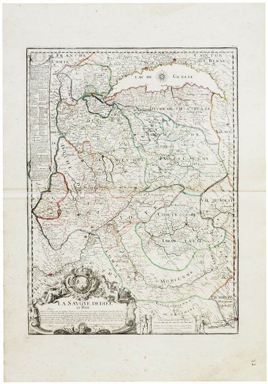
PLACIDE de SAINTE-HÉLÈNE (père).
[SAVOIE] La Savoye, dédiée au Roy.
Paris, Sr. Jaillot, [circa 1710]. 576 x 429 mm.
Bookseller reference : LBW-6287
|
|
|
PLACIDE de SAINTE-HÉLÈNE (père).
Le Cours du Po.
Amsterdam, R. & I. Ottens, [circa 1735]. En 5 feuilles pouvant être jointes pour former une carte de 0,42 x 2,48 m.
Bookseller reference : LBW-4481

|
|
|
PLAN COMMODE DE PARIS
Rues et monuments, autobus et tramways, m?tropolitain. Plan d?pliant hors texte. Sans date.
Cartonn?. 160 pages.
|
|
|
Platzhoff-Lejeune, Dr
Beautiful Switzerland
Neat inscription on 2nd front end paper. No other marks or inscriptions. No creasing to covers, crease to spine. A very clean very tight copy with unmarked card covers loosened at lower part of spine and some bumping to corners. Dust jacket not clipped with dusty rear and well rubbed to edges and corners. Unpaginated. ca 100pp. Description and discussion on Switzerland in English followed by about 80 pages of black & white photographs.

|
|
|
PLAYFAIR (James)
Playfair's New Travelling map of Scotland. Price 4s. 6 d.
1821 emboitage éditeur avec son étiquette. 16 sections montées sur toile et pliées, formant une carte de 570 x 480 mm., aquarellée, Edinburgh Macredie, Skelty & co. 54, Princes street 1821
Bookseller reference : 16324
|
|
|
PLAYNE, SOMERSET (COMPILER), EDITED BY ARNOLD WRIGHT.
Bengal and Assam Behar and Orissa: Their History People Commerce and Industrial Resources.
London and New York.: The Foreign and Colonial Compiling and Publishing Co. 1917. Numerous black and white photographic illustrations. 768pp. Full red morocco binding spine lettered and ruled in gilt in compartments 'Tiger head' emblematical device stamped in gilt on the upper board repeated in gilt on the title page corner ornaments blocked in gilt. All edges gilt marbled endpapers light rubbing to corners but a lavishly produced edition in exceptional condition. 30 x 23.5cm One of a series of publications published with the object of supplying the British public with a picture - complete as far as literary and pictorial effort could make it - of the several different parts of the Empire. in this instance Northern India. . The Foreign and Colonial Compiling and Publishing Co. unknown
Bookseller reference : 214418

|
|
|
Plessix Michel:
Le vent dans les saules.
Guy Delcourt, 2001. 4 cartes au format 16,5 x 11,5 cm., accompagnées de leur enveloppe décorée.
Bookseller reference : 6242

|
|
|
Plog, Uwe
Topographisch militaerische Charte des Herzogthums Holstein. NACHDRUCK der 1789-1796 unter der Direction des Majors G. A. v. Varendorf durch die Lieutenants v. Justi, v. Wimpfen u. Kaup aufgenommenen farbigen Karte.
Braunschweig, Archiv-Verlag, [ca. 1985]. Mehrf. gefalt. farb. Karte (Blattgröße ca. 53 x 84 cm; Bildgröße ca. 48,5 x 78,5 cm).
Bookseller reference : 99382
|
|
|
PLUTARQUE.
Vies des hommes illustres de Plutarque traduites du grec par D. Ricard, ornées de cartes, de bas-reliefs et de portraits d'après l'antique.
1828 Paris , Aug. Dubois, 1828-1833; 5 volumes in-4°, demi - chagrin rouge de l'époque, dos à 5 nerfs plats cernés de filets à froid, filet maigre doré sur les nerfs, auteur, titre et tomaison dorés, tête dorée. Illustré de nombreux portraits tirés sur chine appliqué et de cartes et plans hors texte à double page en couleurs.Nous possédons les Tomes I, IX,X, XI et XII de cette édition, reliés en 5 volumes tomés de 1 à 5 et renfermant :Tome I, daté de 1830. Vie de Plutarque. Thésée. Romulus. LI - 324 pp. Portraits et 5 cartes hors texte. / Tome IX , daté de 1828. Alexandre, César. 432 pp. Portraits et 9 cartes sur 11 (manque la carte de l'Italie septentrionale au temps de César et le plan d'Alexandrie). / Tome X, daté de 1831. Nicias, Crassus, Sertorius, Eumène, Artaxerce. 428 - (3)pp. Portraits et 8 cartes sur 9 (manque carte de la Mauritanie). / Tome XI, daté de 1833. Agésilas, Pompée, Phocion. 397pp. Portraits et 8 cartes ou plans. / Tome XII, daté de 1828. Caton d'Utique, Démosthène, Cicéron. 396pp. Portraits et 9 cartes.
Bookseller reference : 10748

|
|
|
Pneu Michelin
Guide Provence Avec Carte Touristique
142 pages, illustrated, folded map loosely inserted, covers worn. eng
|
|
|
Pogue,Forrest Foreword Omar Bradley, Illustrated by Photos,maps
George C.Marshall: Organizer of Victory1943-1945
Viking. New in New dust jacket. 1986. Third Printing. Hardcover. 0670336947 . Book and DJ New. No notes. Inscribed and signed by not legible "president George C. Marshall Foundation" 1992 at half title page. NO other names or ANY markings. DJ not clipped $29.95 ; Ships in a box USA. ; Thick 8vo; 683 pages . Viking hardcover
Bookseller reference : 38937 ISBN : 0670336947 9780670336944
|
|
|
POINCARÉ (Antoine)
Notice sur la distribution et marche des pluies dans la département de la Meuse, le bassin supérieur de la rivière Meuse et une zone avoisinante du bassin de la Seine
43, (1) pages et (2) cartes depl broché, couverture imprimée de l'éditeur 1873, 1873, in-8, 43, (1) pages et (2) cartes depl, broché, couverture imprimée de l'éditeur, Rare tiré à part non coupé. A travers cette brochure, Poincaré traite des trois modes de représentation (isoombres, suivies et horaires) des phénomènes météorologiques, modes employés avec beaucoup de réticence à l'époque. Il explique notamment les légendes des deux cartes qu'il a réalisées pour représenter les pluies tombées sur la Meuse et le bassin de la Seine durant l'hiver 1868-1869. En 1871, Poincaré présente à la Commission de l'Association Scientifique de France une étude en 7 parties intitulée "études sur la distribution et la marche des pluies dans la région". Un résumé sera publié peu après dans le n° 211 de la revue hebdomadaire de l'institution. Antoine Poincaré, polytechnicien et ingénieur en chef à Bar-le-Duc fut l'oncle du mathématicien et physicien Henri Poincaré et le père de Raymond Poincaré, président de la France de 1913 à 1920. Malgré la présence minime de rousseurs et de taches sur les couvertures, bel exemplaire
|
|
|
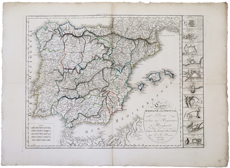
POIRSON (Jean-Baptiste).
Carte d'Espagne et de Portugal divisée en tous ses royaumes et principautés.
Paris, Jean, An 1823. 486 x 649 mm.
Bookseller reference : LBW-5185
|
|
|
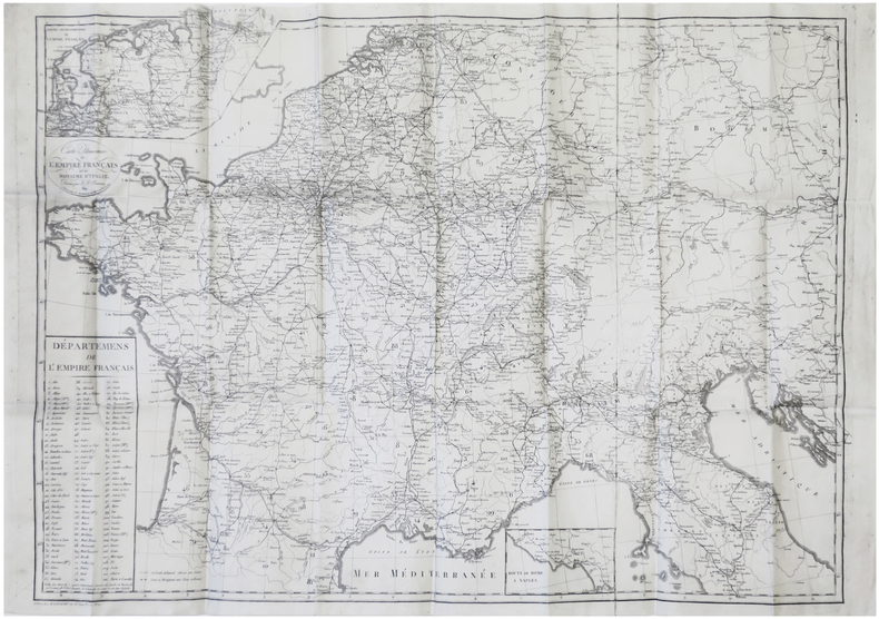
POIRSON (Jean-Baptiste).
Carte itinéraire de l'Empire français et du royaume d'Italie.
Paris, H. Langlois, 1812. 550 x 800 mm ; repliée et montée dans une reliure en veau vert de l'époque ; sur le premier plat, titre et nom du propriétaire de la carte en lettres dorées : Carte de voyage. M Jules Joly.
Bookseller reference : LBW-7711
|
|
|
POIRSON, Jean Baptiste (1761-1831). Cartographe
CARTE ITINÉRAIRE DE LA FRANCE : donnant toutes les routes de poste, les lieux de relais, les routes des messageries et autres divisée en ses 110 départemens avec leur Chefs-lieu, et Tribunaux & dressée sur les dernières observations Astronomiques par J.B. POIRSON 1806
paris chez Jean 1806 une carte entoilée (map cloth-lined map), dimensions de la carte dépliée (Dimensions of the unfolded map - size in Inches) : 90 X 67,5 CM , 1806, Gravée par Jean, Pierre, POIRSON, Jean Baptiste (1761-1831). Cartographe. À Paris, chez Jean Editeur
Bookseller reference : 26526
|
|
|
Poirson, Jean-Baptiste
Carte de la France. Divisée en 117 départemens [sic!] en arrondissements communaux et augmentée des départements du Duché de Berg.
Paris, Jean, 1810. Mehrfach gefaltete gestochene Karte mit Grenzkolorit. Maßstab: ca. 1:1.900.000. Blatt 65 x 85 cm, gefalzt zu 19 x 12 cm. Ppb dt. Zt mit Deckelschildchen.
Bookseller reference : 90205
|
|
|
POLACK (Joel Samuel)
New Zealand : being a narrative of travels and adventures during a residence in that country between the years 1831 and 1837.
London, Richard Bentley, 1838. 2 volumes in-8 (21 x 13 cm), veau fauve glacé (reliure de l'époque), dos lisse orné, pièces de titre et de tomaison en maroquin grenat et olive, dentelles dorées et triple filet à froid encadrant les plats, roulette dorée intérieure et sur les coupes, tranches peignées, xii-403-[1];vi-441-[1] pages (complet). Coins usés, charnières frottées et fendues, coiffes accidentées ,manque au dos avec épidermure .
Bookseller reference : PHO-1194

|
|
|
Polgar BSc(Hons) MSc, Stephen; Thomas DipPubPol PhD MAPS, Shane A
Introduction to Research in the Health Sciences
Elsevier 2019-11-25. paperback. Good. 7x0x9. Textbook May Have Highlights Notes and/or Underlining BOOK ONLY-NO ACCESS CODE NO CD Ships with Tracking Elsevier paperback
Bookseller reference : SKU0594671 ISBN : 0702074934 9780702074936

|
|
|
Polgar BSc(Hons) MSc, Stephen; Thomas DipPubPol PhD MAPS, Shane A
Introduction to Research in the Health Sciences
Elsevier 2019-11-25. paperback. New. 7x0x9. New Textbook Ships with Tracking Elsevier paperback
Bookseller reference : SKU0642178 ISBN : 0702074934 9780702074936
|
|
|
Polgar BScHons MSc Stephen; Thomas DipPubPol PhD MAPS Shane A
Introduction to Research in Health Sciences
Churchill Livingstone 2000-08-10. Paperback. New. In shrink wrap. Looks like an interesting title! Churchill Livingstone paperback
Bookseller reference : Q-044306265x ISBN : 044306265X 9780443062650

|
|
|
Polgar BSc(Hons) MSc, Stephen; Thomas DipPubPol PhD MAPS, Shane A
Introduction to Research in the Health Sciences
Churchill Livingstone 2007-11-21. Paperback. New. In shrink wrap. Looks like an interesting title! Churchill Livingstone paperback
Bookseller reference : Q-0443074291 ISBN : 0443074291 9780443074295

|
|
|
Polgar BScHons MSc Stephen Thomas DipPubPol PhD MAPS Shane A
Introduction to Research in the Health Sciences
Churchill Livingstone. Used - Good. Ships from UK in 48 hours or less usually same day. Your purchase helps support Sri Lankan Children's Charity 'The Rainbow Centre'. Ex-library so some stamps and wear but in good overall condition. May contain underlining and/or highlighting. 100% money back guarantee. We are a world class secondhand bookstore based in Hertfordshire United Kingdom and specialize in high quality textbooks across an enormous variety of subjects. We aim to provide a vast range of textbooks rare and collectible books at a great price. Our donations to The Rainbow Centre have helped provide an education and a safe haven to hundreds of children who live in appalling conditions. We provide a 100% money back guarantee and are dedicated to providing our customers with the highest standards of service in the bookselling industry. Churchill Livingstone unknown
Bookseller reference : Z1-C-057-01816 ISBN : 0443074291 9780443074295
|
|
|
POLLACCHI (Cartes), DELONCLE (Index et glossaire) et CROUZET (Rapport Général)
Cartes-Index, Glossaire, Documents annexes, Rapport général - Cahiers du Centenaire de l'Algérie XII
Publications du Comité National Métropolitain du Centenaire de l'Algérie, 1930. In-8 broché, 72 p. + 5 cartes dépliantes en couleurs. Bon état.
Bookseller reference : 8678
|
|
|
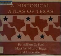
Pool, William C.; Maps by Edward Triggs and Lance Wren
A Historical Atlas of Texas
Austin TX: Encino Press 1975. Hardcover. Near Fine/Very Good. Hardcover with orange cloth boards in dust jacket 1975 oblong quarto 190pp. illustrated with brown maps. Book near fine with handsome boards and tight binding previous owner's signature to front flyleaf otherwise text clean and unmarked. DJ VG with rubbing edgewear that includes some small tears and their related creases toning. Encino Press hardcover
Bookseller reference : B35751 ISBN : 088426033x 9780884260332
|
|
|
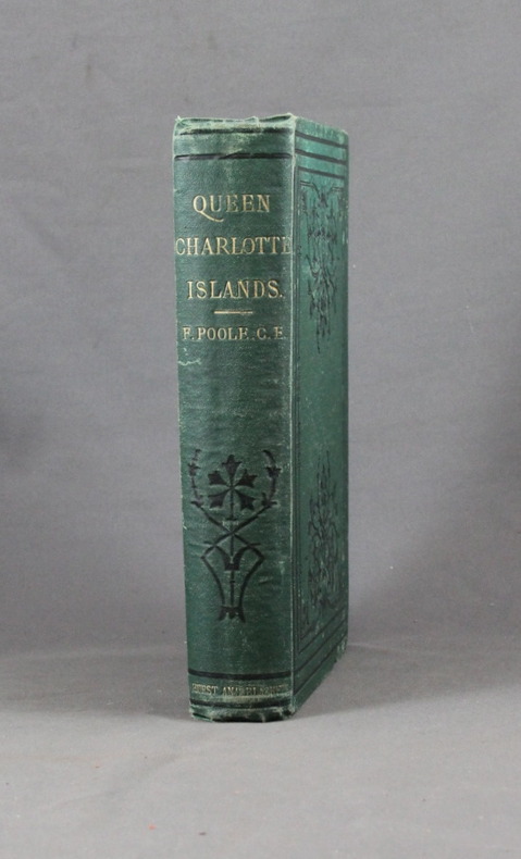
POOLE Francis; Lyndon, John W. (éditeur):
Queen Charlotte Islands, A Narrative of Discovery and Adventure in the North Pacific.
London, Hurst & Blackett, 1872. In-8 de XIV-[2]-347p. + 16p. de catalogue, pleine percaline verte d'éditeur ornée de fleurons à froid. Rousseurs sur la page de titre et le frontispice uniquement (à cause de la serpente).
Bookseller reference : 6193
|
|
|
PopOut Maps
Amsterdam PopOut Map - handy pocket-size pop up map for Amsterdam Popout Maps
Compass Maps 01/17/2014. Fol Map. Map. Used; Good. WE SHIP WITHIN 24 HRS FROM LONDON UK 98% OF OUR ORDERS ARE RECEIVED WITHIN 7-10 DAYS. We believe you will be completely satisfied with our quick and reliable service. All orders are dispatched as swiftly as possible! Buy with confidence! Greener Books. Compass Maps unknown
Bookseller reference : 5033852 ISBN : 1845879759 9781845879754

|
|
|
PopOut Maps (Author)
Amsterdam Popout Map - Pocket Size Pop Up Map Of Amsterdam City Centre: Includes Transport Map
like new. unknown
Bookseller reference : 50353723 ISBN : 1917131321 9781917131322

|
|
|
PopOut Maps (Author)
Amsterdam Popout Map - Pocket Size Pop Up Map Of Amsterdam City Centre: Includes Transport Map
new. unknown
Bookseller reference : 50353723-n ISBN : 1917131321 9781917131322
|
|
|
PopOut Maps (Author)
Amsterdam Popout Map - Pocket Size Pop Up Map Of Amsterdam City Centre: Includes Transport Map
Heartwood Publishing 2025. Sheet Map Folded. New. new ed edition. 2 pages. 5.12x0.16x3.74 inches. Heartwood Publishing unknown
Bookseller reference : __1917131321 ISBN : 1917131321 9781917131322
|
|
|
PopOut Maps
Amsterdam PopOut Map - pocket size pop up map of Amsterdam city centre: Includes transport map
Sheet map folded. New. Explore vibrant Amsterdam with this handy pop-up map. This genuinely pocket-sized Amsterdam map includes 2 PopOut maps - a street map of central Amsterdam a map of historic Amsterdam as well as a map of the museum district and a transport map. Ideal to pop in a pocket or bag for quick reference. unknown
Bookseller reference : A9781917131322 ISBN : 1917131321 9781917131322

|
|
|
Popout Maps (Corporate Author)
Amsterdam Popout Map
Compass Maps Ltd 2020. Paperback. New. fol map edition. 2 pages. 3.75x5.25x0.47 inches. Compass Maps Ltd paperback
Bookseller reference : 1-191021891X ISBN : 191021891X 9781910218914

|
|
|
PopOut Maps
Amsterdam PopOut Map - handy pocket-size pop up map for Amsterdam Popout Maps
Compass Maps 01/17/2014. Fol Map. Map. Used; Good. WE SHIP WITHIN 24 HRS FROM LONDON UK 98% OF OUR ORDERS ARE RECEIVED WITHIN 7-10 DAYS. We believe you will be completely satisfied with our quick and reliable service. All orders are dispatched as swiftly as possible! Buy with confidence! Greener Books. Compass Maps unknown
Bookseller reference : 2502868 ISBN : 1845879759 9781845879754
|
|
|
Popout Maps
Amsterdam PopOut Map PopOut Maps
Paperback. Good. paperback
Bookseller reference : GOR006817979 ISBN : 1845878620 9781845878627

|
|
|
Popout Maps
Amsterdam PopOut Map PopOut Maps
Paperback. Very Good. paperback
Bookseller reference : GOR005201356 ISBN : 1845878620 9781845878627

|
|
|
PopOut Maps
Barcelona PopOut Map - handy pocket-size pop up Barcelona city map Popout Maps
Compass Maps. 3rd edition. Map. Used; Good. Simply Brit welcome to our online used book store where affordability meets great quality. Dive into a world of captivating reads without breaking the bank. We take pride in offering a wide selection of used books from classics to hidden gems ensuring theres something for every literary palate. All orders are shipped within 24 hours and our lightning fast-delivery within 48 hours coupled with our prompt customer service ensures a smooth journey from ordering to delivery. Discover the joy of reading with us your trusted source for affordable books that do not compromise on quality. 01/17/2014 Compass Maps unknown
Bookseller reference : 4269383 ISBN : 0711600301939 0711600301
|
|
|
PopOut Maps
Barcelona PopOut Map PopOut Maps
PopOut Maps 04/14/2017. Fully revised and u. Map. Used; Good. WE SHIP WITHIN 24 HRS FROM LONDON UK 98% OF OUR ORDERS ARE RECEIVED WITHIN 7-10 DAYS. We believe you will be completely satisfied with our quick and reliable service. All orders are dispatched as swiftly as possible! Buy with confidence! Greener Books. PopOut Maps unknown
Bookseller reference : 5012739 ISBN : 0711600302629 0711600302
|
|
|
Popout Maps
Barcelona Popout Map
map. Good. Access codes and supplements are not guaranteed with used items. May be an ex-library book. unknown
Bookseller reference : 1845878590.G ISBN : 1845878590 9781845878597
|
|
|
Popout Maps
Barcelona PopOut Map PopOut Maps
Paperback. Very Good. paperback
Bookseller reference : GOR004328200 ISBN : 1845878590 9781845878597

|
|
|
PopOut Maps (Author)
Bath PopOut Map PopOut Maps
Heartwood Publishing 2025. map. New. 1 pages. 5.12x0.16x3.74 inches. Heartwood Publishing unknown
Bookseller reference : __1917131186 ISBN : 1917131186 9781917131186
|
|
|
PopOut Maps
Bath PopOut Map - pocket size pop up map of Bath city centre
Sheet map folded. New. Explore the splendour of Georgian Bath with this handy pop-up map. This genuinely pocket-sized Bath city map features a detailed street map of Bath as well as advice on the top things to see while you’re there. Ideal to pop in a pocket or bag for quick reference while discovering this magical city. unknown
Bookseller reference : A9781917131186 ISBN : 1917131186 9781917131186

|
|
|
PopOut Maps (Author)
Bath PopOut Map PopOut Maps
new. unknown
Bookseller reference : 48318606-n ISBN : 1917131186 9781917131186
|
|
|
PopOut Maps (Author)
Bath PopOut Map PopOut Maps
like new. unknown
Bookseller reference : 48318606 ISBN : 1917131186 9781917131186
|
|
|
PopOut Maps
Beijing PopOut Map
map. Good. Access codes and supplements are not guaranteed with used items. May be an ex-library book. unknown
Bookseller reference : 1845876237.G ISBN : 1845876237 9781845876234

|
|
 Receive by email
 Download as PDF document
 RSS feed


