|
[PHOTOGRAPHIE].-
L'Artiste Photographe.-
ND Photo. Série des Scènes Parisiennes. (Vers 1905). Carte postale (14x9cm) ayant voyagé, oblitération de 1906. Tout petit défaut à un coin sinon bon état. Rare.
Referenz des Buchhändlers : ORD-8404
|
|
|
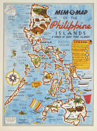
[PHILIPPINES - WORLD WAR II MAP] DRURY, JOHN G. (MAPMAKER).
Mem-O-Map of the Philippine Islands. A Group of Over 7000 Islands.
U.S.A.: Mem-O-Map Co. 1945. Colour pictographic / pictorial map 32.1 x 23.8 cms; 35.4 x 26.6 cms sheet very good condition. Rare pictorial map published in 1945 by John G. Drury aTechnical Officer who served with the 214th Ordnance Battalion to mark the end of World War II as souvenirs for the military. Military personnel could fill in banners "came in on good ship." and "departed on good ship." their name organisation and "Line of Advance or movement" blank in this example. Pictographs mark various memorable spots and wildlife including larger-than-life insects. A "Terrible Tillie Typhoon" looms over the coast at Luzon. <br>Drury published a series of five maps: Philippines and Okinawa in 1945; Japan and Korea Oahu and Europe in 1946. They are all scarce. “These almost whimsical maps are designed to support the creation of personalised geographies. At a time when digital mapping is beginning to experiment with the creation of personalised content that would render the same map in different ways for different users Mem-O-Maps demonstrate the principle in action." Kenneth Field ICA Commission on Map Design. . Mem-O-Map Co. unknown
Referenz des Buchhändlers : 204557
|
|
|
[PHNOM PENH - MAPS AND BROCHURE].
金邊 游客順知. Jinbian - Youke shunzhi. Tourist Brochure of Phnom Penh.
國家旅行社. National Travel Company. Circa1960s. Folding tourist brochure of Phnom Penh and environs in total 64.5 x 49.8cm 15 panels folded size 21.5 x 9.8cm. Two maps one of the city of Phnom Penh with street names in Khmer transliterated into Latin script 43 x 30cm. On reverse a coloured topographical map of southen Cambodia showing border with Vietnam 20 x 28.5cm. Numerous black and white photographic illustrations to accompany information on flights trains tourist entry requirements sights of interest to tourists. All information in traditional Chinese characters. Slight browning on one panel and two small holes mended with washi paper else in very good condition. Of particular interest in the visitor information is a description of an area about 150 km from the city of Phnom Penh which tourists can visit to take photographs of or hunt wild animals as long as they bring their own rifles. . 國家旅行社. National Travel Company. unknown
Referenz des Buchhändlers : 217495
|
|
|
[PHOTOGRAPHS OF MAPS SHOWING LAND USE IN PAKISTAN].
Pakistan: Land Forms and Land Use.
circa1970. Collection of 20 black and white photographic plates with their accompanying negatives of maps showing patterns of land use and land forms throughout Pakistan. These photographs are of two sets of maps prepared by the Canadian government covering the whole of Pakistan. A very useful set. From the collection of Professor Basil Johnson Emeritius Professor of Geography at the Australian National University Canberra. From the collection of geographer Professor Basil Johnson who was the author of a number of works on South Asia including "India Resources and Development" and "Geographical Dictionary of India". . unknown
Referenz des Buchhändlers : 54789

|
|
|
[Photographie - Rom].
Roma. [Rom, um 1900].
36 Albuminabzüge (ca. 12:17 cm), montiert in rotes Originalleinenalbum mit goldgepr. Deckeltitel. Gr.-qu.-8vo. Schöne, teils etwas ausgebleichte Originalphotographien römischer Baudenkmäler um 1900, darunter Petersdom, Lateranbasilika, S. Maria Maggiore, Colosseum, Titusbogen, Forum romanum, Pantheon, Vestatempel, Trevibrunnen, Engelsburg, Piazza Navona, Trajanssäule, Cestiuspyramide und Statuen aus den Vatikanischen Sammlungen (Laokoongruppe, Perseus etc.). - Schwach wellig verzogen.

|
|
|
[PICQUET (Charles)].
Plan routier de la ville de Paris. ou Guide des étrangers dans cette capitale, divisé en XII arrondissements ou mairies, et en 48 quartiers, offrant Paris tel qu'il est aujourd'hui, avec les noms des rues, quais, places, &c., inscrits conformément aux ordonnances royales
Paris, Ch. Picquet, 1833 plan dépliant de 59 x 89 cm, en feuilles, entoilées.
Referenz des Buchhändlers : 227567

|
|
|
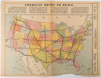
[PICTORIAL - PRE WWII MAP] BURKE, HOWARD AUSTIN [1899-1967.]
American Roads to Peace
Los Angeles.: Los Angeles Examiner. Sunday 1 May1938. Printed colour pictorial map 33 x 48 cms; 41.8 x 54.5 cms sheet central fold sheet toned corners chipped with some loss to the bottom border and at the central fold in good condition; and on the verso "Movie-Go-Round" by Louella O. Parsons black and white photos and advertisements. Pictorial map printed for the weekend supplement of the Randolph Hearst owned newspaper the Los Angeles Examiner. The map-maker and artist Howard Burke had also worked for the San Francisco Examiner and was known for pictorial maps many with a persuasive or rhetorical edge and as here were designed to shore up American patriotism and defences against a wider world in the increasingly turbulent pre-war 1930s. The caption to this map outlines a multi-billion dollar 25 year proposal by Congressman J. Buell Snyder for a network of coast to coast transcontinental highways "in case of an attack by a foreign power at any point along the border". Buell Snyder earned the soubriquet "the father of superhighways" and during the War he was assigned to a Congressional Committee in charge of appropriations for the War Department. Scarce. . Los Angeles Examiner. unknown
Referenz des Buchhändlers : 215547
|
|
|
[PLAN-PARIS] BERTHIER (Alexandre).
Carte topographique des environs de Versailles dite des chasses impériales.
Picquet, (ca. 1810), 46 x 80.5 cm (cuvette) - 55.5 x 82 cm (feuille) , Légères rousseurs. Petite déchirure n'atteignant pas la composition.
Referenz des Buchhändlers : 232345
|
|
|
[PLAN MANUSCRIT] ROCHETTE, BOISLISLE, CORTEZ.
Fort de France. les travaux utilisés sont de M.M. les enseignes de Vaisseau de 2ème classe - Croiseur Suffren
Novembre-Décembre 1930 à vue : 50 x 31 cm - cadre : 53 x 34 cm , cadre en bois verni d'époque. Rousseurs.
Referenz des Buchhändlers : 231856

|
|
|
[PLAN].
Nouveau plan illustré de la ville de Paris. indiquant les changements, les voies projetées et en cours d'exécution
Paris, Imprimerie Monceau, 1867 plan dépliant de 59 x 89 cm, en feuille. Des déchirures à plusieurs pliures.
Referenz des Buchhändlers : 227571

|
|
|
[PLAN - PARIS] DELAGRIVE (Jean), BAILLEUL (Nicolas dit le Jeune). (D'après)
Paris et ses environs.
(Fin du XIXème siècle), 60 x 87 cm (cuvette) - 68 x 100 cm (feuille), Pliures. Signature de Nicolas Bailleul effacée.
Referenz des Buchhändlers : 232333

|
|
|
[PLAN]
Plan routier de la ville et faubourg de Paris.
Paris, Lattré, 1775 carte dépliante de 55 x 76 cm repliée au format in-8, en feuilles, entoilées, petits trous à certaines pliures, une tache au niveau du faubourg Saint-Antoine.
Referenz des Buchhändlers : 210292

|
|
|
[PLAN]
Plan routier de la ville et fauxbourgs de Paris. divisé en douze mairies. Revu et corrigé par Hérisson, géographe
Paris, Jean, 1832 carte dépliante de 61 x 89 cm, contours rehaussés de couleurs, en feuille, bords très ébarbés, quelques salissures.
Referenz des Buchhändlers : 210295
|
|
|
[PLANS DE PARIS].
Plant et pourtrait de la ville, cité et université de Paris. Introduction et notes par l'abbé Valentin Dufour
Collection Anciennes descriptions de Paris, VIIIParis, A. Quantin, 1883 petit in-8, [2] ff. n. ch., LXXXIII pp., 53 pp., un f. n. ch. de table, avec 3 plans dépliants hors texte, broché.
Referenz des Buchhändlers : 227357

|
|
|
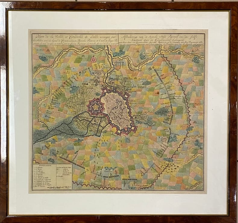
[PLAN] VISSCHER (Nicolaes Janz).
Plan de la Ville et Citadelle de Lille,. assiégée par les Alliez avec les lignes de Circumvalation, Approches, Bateries et le nom de chaque Régiment - Afbeeldinge van de stercke stad Ryssel en des felfs Kasteel door de Geallieerde beleegert, met haar linie van circumvalatie, aproches, battaryen en de de Naamen van jder regement. Le tout dessigné au naturel par un fameux Ingénieur. La tranchée fut ouverte le 22 aout 1708 alles door een voornaamen ingenieur, naa t leven geteekent, de Frencheen zyn den 22 August : 1708 geopent.
[Amsterdam], [1708] 49 x 53.5 (cuvette) - 68 x 73 cm (cadre), encadrement contemporain en bois verni. Quelques pliures. Infimes taches.
Referenz des Buchhändlers : 231959
|
|
|
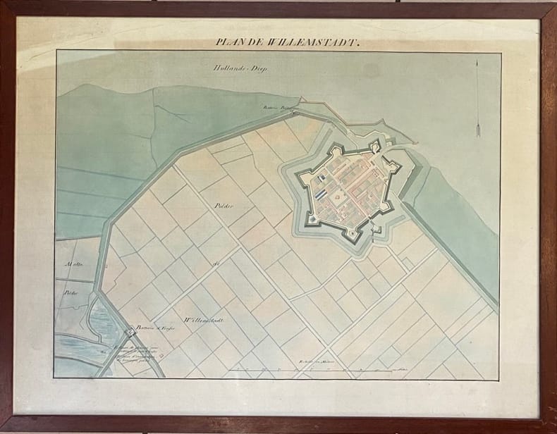
[PLAN MANUSCRIT]
Plan de Willemstadt.
(XVIIIème siècle) 48.5 x 63.5 cm (à vue) - 52.5 x 68 cm ( cadre) , cadre en bois verni. Déchirures dans la partie supérieure n'atteignant pas la composition. Insolé.
Referenz des Buchhändlers : 232205
|
|
|
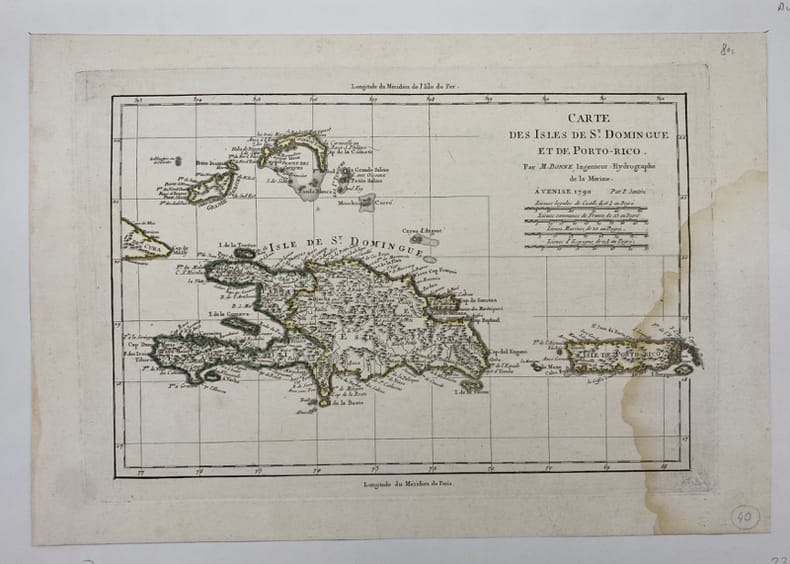
[PORTO-RICO/SAINT-DOMINGUE] BONNE (Rigobert).
Carte des Isles de St Domingue et de Porto-Rico.
Venise, (c.1790), , Mouillure sur le côté droit.
Referenz des Buchhändlers : 231866
|
|
|
[Pro Juventute]:
Reproductions de timbres Helvetia, 1921 à 1926.
6 cartes présentant 6 timbres de la série Helvetia, Pro Junventute, de 1921 à 1926. Format des reproductions 15 x 18 cm.
Referenz des Buchhändlers : 16617

|
|
|
[Proust, Marcel] George D. Painter, with illustrations, maps drawn by Samuel H. Bryant
Proust; the early years
Boston: Atlantic Monthly Press/Little Brown and Company 1959. Hardcover. xvii 435p. 8p. photos later printing cloth edgeworn dj. Atlantic Monthly Press/Little, Brown and Company hardcover
Referenz des Buchhändlers : 94939

|
|
|
[Ptolomaeus, Claudius]. - Sanz, Carlos
La Geographia de Ptolomeo. Ampliada con los primeros mapas impresos de América (desde 1507). Estudio bibliografico y critico. Con el catalogo de las ediciones aparecidas desde 1475 a 1883. Comentado e ilustrado.
Madrid, Victoriano Suarez, 1959. 4°. Mit zahlr. meist ganzs. Abbildungen. 281 S., 2 Bll., Lwd. d. Zt. m. goldgepr. Rückentitel u. dem eingeb. OUmschlag.
Referenz des Buchhändlers : 48400

|
|
|
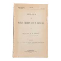
[Puerto Rico] [Maps] [Spanish-American War] Greely, Brig. Gen. A. W.
Report on Military Telegraph Lines in Porto Rico
Washington D.C.: Government Printing Office 1900. First edition. 8vo 100pp. Color folding map 42x108cm attached at rear. Stitched lacking wrappers or disbound from a larger publication paper toned with light chipping. Map clean. A good copy. <br /> <br /> Senate Document No. 429 56th congress. This report was given by Adolphus Washington Greely 1844-1935 then Brigadier General and Chief Signal Officer of the U.S. Army. Greely was in charge of maintaining communications networks during the Spanish-American War and oversaw construction and maintenance of telegraph lines in Puerto Rico Cuba and the Philippines.  <br /> <br /> The map in this report is "Map of the Island of Porto Rico Showing the lines of signal communication telegraph telephone and heliograph operated by the Signal Corps U.S. Army with Military Posts." It was prepared by major William A. Glassford under the direction of Greely.   <br /> <br /> <br /> OCLC cites 11 holdings.  . Government Printing Office unknown
Referenz des Buchhändlers : 6902
|
|
|
[Qatar - Bahrain - El Katif].
Hofuf. World 1,000:000. Series 1301. Edition 5-GSGS. Sheet NG39. [London], War Office and Air Ministry, 1963.
Colour-printed map, ca. 750 x 610mm. Scale: 1:1,000,000. Rare 5th GSGS edition of this map of Qatar, Bahrain, and Ras Tanura in Saudi Arabia, as part of the International Map of the World series. Depicts Saudi Arabia from As Saffaniyah in the North over Hofuf, to Hidiba in the South. Shows boundaries, highways and roads, railways, airports, rivers and water features, and other details. - Two small brown spots to the image and a nick to the top edge, some creasing near margins. OCLC 34907145.
|
|
|
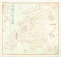
[QINGDAO IN 1938].
青島市街地図. Chintao shigai chizu. Japanese Plan of Qingdao City.
Qingdao: Taiheiyoko. 太平洋行. 昭和 13 1938. Coloured folding plan of Qingdao in 1938. some browning on reverse with a small lighter section on map Japanese place names no scale 36 x 39cm 3 inset maps. This 1938 Qingdao city map shows street names in Chinese characters and location of Chinese and Japanese public buildings such as the hospital shrines Japanese primary schools and high schools. The 3 inset maps show railway and transport routes as well as outskirts of the city. . [Taiheiyoko]. 太平洋行. unknown
Referenz des Buchhändlers : 171093
|
|
|
[REIMS] COLIN (Jean).
Plan de la Ville Cité et Université de Reims.
Jamas, s.l., 1655 (1930-32). Grand plan divisé en 4 feuilles de 39 x 72 cm chacune. Quelques taches et une petite déchirure en marge.
Referenz des Buchhändlers : 14136

|
|
|
[Reinegg, Jacob]
Tabula Itineraria a Sues usque ad Dsjabbel el Mokatteb et Montem Sinai. [Bildinschrift: Báhhr el Kolsum s. Báhhr es Sues; Báhhr el Akaba]. Kupferstichkarte mit Titelkartusche, Windrose u. 2 Meilenzeigern.
Kopenhagen, André Philippe de Pretot, 1772. Blattmaß 28 x 40 cm; Bildmaß 18 x 28,5 cm.
Referenz des Buchhändlers : 78798
|
|
|
[ROCHAMBEAU, Jean-Baptiste Donatien, de Vimeur comte de].
I. « Plan des ville, citadelle, forts et port de Calais »; II. Cassini. Carte particulière des environs de Lille, Tournay, Valenciennes, Bouchain, Douay, Arras, Béthune. 1745.
[I. France, circa 1780]. II. Bruxelles, chez George Fricx, rue de la Madeleine, imprimeur. 1745. 1780 I: 1 feuille de 1 102 mm par 511 mm, tracée à l'encre et aquarellée ; II: 1 feuille de 420 mm par 456 mm, imprimée en noir. Les deux sont contrecollées sur toile. Cartonnage-étuis d'époque à rabats.
Referenz des Buchhändlers : 4944

|
|
|
[RONDEAUX DE SETRY] LOYER.
Plan de la Ville de Rouen renfermée dans sa 1ère enceinte comme elle était sous Raoul et nos premiers ducs qui l'augmentèrent beaucoup du coté du midi et ressérèrent le lit de la rivière de près d'un tiers.
s.d. (XIXème). Plan manuscrit aquarellé (41 x 26 cm), légende des lieux en marge.
Referenz des Buchhändlers : 13279

|
|
|
[RONDEAUX DE SETRY] RENAUD (C. R.).
Rouen au X & au XIe Siècle.
1882. Plan manuscrit aquarellé (55 x 35 cm), nombreuses annotations manuscrites reprises sur le plan original.
Referenz des Buchhändlers : 9933

|
|
|
[RUCHAT Abraham; THURNEYSEN Emanuel; STANYAN Abraham; ALTMANN Johann Georg:
Etat et délices de la Suisse ou Description historique et géographique des treize cantons suisses et de leurs alliés. Nouvelle édition, corrigée & considérablement augmentée par plusieurs auteurs célèbres, & enrichie de figures en taille douce & de cartes géographiques.
A Neuchâtel, chez Samuel Fauche, 1778. 2 volumes in-4 de [4]-454-[2] et [4]-388 pages, demi-basane blonde, dos lisses ornés de roulettes, filets, fleurons, titre et tomaison dorés, étiquettes de titre et tomaison rouges, tranches jaunes. Dos un peu frottés, mors du premier volume fendu en queue sur 5 cm., premières charnières faibles, un cahier très légèrement déboîté.
Referenz des Buchhändlers : 10246
|
|
|
[RUSSO-JAPANESE WAR - TWO NEWSPAPER MAPS].
旅順包圍攻撃圖. 日露戰爭經過圖. Ryojun hōi kōgekizu. Nichiro Sensō keikazu. Pictorial Map of Seizure of Port Arthur AND Russo-Japanese War Development Map.
大阪. Osaka.: 大阪毎日新聞社. Ōsaka Mainichi Shinbunsha. Meiji 37 1904. Two black and white newspaper maps issued in the Ōsaka Mainichi Shinbunsha one pictorial with accompanying text and adverts printed on newsprint folded. 39.5 x 55cm Very good condition. This pictorial map of Port Arthur and Dalian was published on 4 July 1904 by the Osaka Mainichi Shinbun as a supplement. It shows Port Arthur encircled by Japanese naval vessels while Dalian is depicted as being occupied by Japanese troops. On the reverse there is an essay on the war accompanied by illustrations of Russian generals and a list of wounded soldiers who had been transported to the rear.<br><br>A second map detailing developments in the Russo-Japanese War was published by the same newspaper just days later on 8 August 1904. This map provides the dates of various battles along with a chronology of the movements of the Russian Vladivostok fleet and Japanese attacks on Port Arthur. These two maps are rare examples of the kind of information made available to the general public on a day-to-day basis during the war. . 大阪毎日新聞社. [Ōsaka Mainichi Shinbunsha]. unknown
Referenz des Buchhändlers : 216797
|
|
|
[sans auteur] - RIQUETTI [ou RIQUETI] (Victor, Comte de MIRABEAU).
Atlas de la monarchie prussienne [sous Frédéric le Grand].
A Londres, s.é. [Lejay], 1788. Un fort vol. au format in-folio (433 x 277 mm) de 3 ff. n.fol., [10] cartes gravées sur double-page,, 93 planches gravées + tableaux et 1 f. bl. Ne subsiste plus de la reliure que le carton des plats.
Referenz des Buchhändlers : 26048

|
|
|
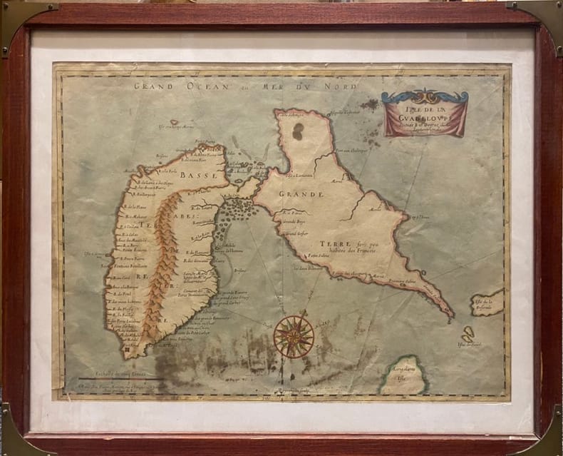
[SANSON D'ABBEVILLE (Nicolas)].
Isle de la Guadeloupe. Scituée à 16 degrez de Lat .Septentrionale. A Paris chez Pierre Mariette, rue S.Iacques à L'Espérance. Avec Privilège du Roy
Paris, MARIETTE Pierre, (vers 1662) à vue : 32 x 43,5 cm - cadre : 43 x 52.5 cm , Cadre du XXe siècle. Déchirures dont une au coin inférieur gauche et une au niveau inférieur de la pliure centrale. Taches.
Referenz des Buchhändlers : 230537
|
|
|
[sans auteur].
Petit atlas national des 86 départements de la France et de ses colonies.
(Paris), Blaisot, 1835. Un fort vol. au format pt in-4 (263 x 182 mm) de 1 titre-frontispice n.fol. et [99] planches gravées sur double-page. Reliure de l'époque d edemi-basane glacée sapin, dos lisse orné de doubles filets dorés, larges fleurons romantiques dorés, titre doré.
Referenz des Buchhändlers : 26317

|
|
|
[SAINTE-HÉLÈNE] READ (R. P.).
The Geographical plan of the island & forts of Saint Helena.
[London, Burgis & Barfoot], (1841) 42 x 56 cm, encadrée sous verre (encadrement postérieure). Pliure centrale.
Referenz des Buchhändlers : 244229
|
|
|
[Sahara Maps] [Algiers] Sabatier, Camille
La Question du Sud-Ouest
Algiers: Adolphe Jourdan Libraire-Editeur 1881. First edition. 22x14cm vi 70 2. Large folding map "Carte du Sahara Central par M. Camille Sabatier" and table of contents at rear. Stitched in gray laid paper wraps. Single pencil annotation on pg. 47 else clean internally and nearly fine. <br /> <br /> Scarce French Algerian text by Camille Sabatier 1851-1919 lawyer and politician who wrote extensively on the geography and politics of the Sahara region. Sabatier was French deputy in Algeria from 1885-1889. He was a member of the geographical societies of Oran and Algiers and prepared the map in this text with the assistance of French cartographer Justin Pouyanne.<br /> <br /> The work focuses on the local tribes of the Sahara region including Hamyan Trafi Laghouati Chambaa Ait-Atta Arib and Doui-Menia their interactions religions etc. The text also details trade routes geography and climate of the region arguing the ignorance of seeing the Sahara as just "a sea of sands" leads to political surprise and disaster.  <br /> <br /> OCLC cites 6 holdings 4 of them in France.  <br /> <br /> <br /> . Adolphe Jourdan, Libraire-Editeur unknown
Referenz des Buchhändlers : 9118
|
|
|
[Saudi Arabia and Yemen].
Collection of USAF Aeronautical Charts. Washington, DC, Army Map Service, 1942 and 1944.
8 charts. 560 x 735 mm, with key printed on the back. Scale 1:1,000,000. Substantial set of first edition U.S. pilot charts from the Second World War. Includes 2 maps of the Arabian Peninsula (668 and 669), depicting the border region of Saudi Arabia, Yemen and the Aden Protectorate and covering the area between the 42nd and 54th meridian east, and between the 16th and 20th parallel north. Also shows the Frasan Islands as well as large parts of the Rub' al Kahli desert with sections marked "unexplored", the city of Salala constituting the easternmost point. - Further, two maps of Iran (429 and 443) between the 53rd and 60th meridian east, and the 28th and 36th parallel north, identifying Kerman, Yazd and Birjand. - The remaining maps cover western Afghanistan (439), labelling Herat and Farah, central India (559), with cities such as Jabalpur, Bhopal and Achalpur, and the Indian Ocean showing the Chagos archipelago (1037) and Comoro Island (1052). - Chart no. 1037 dampstained with loss to the centre, chart no. 669 lacks approx. 5.5 cm, clipped away at upper margin. Remaining maps with occasional small tears, but overall in good condition.
|
|
|
[Saudi Arabia].
Abl Ghamghimah. Series K 502, Sheet NE 39-4, Edition 1-AMS. Washington, D.C., Army Map Service, 1965.
Folding map. Ca. 755 x 570 mm. Scale 1:250,000. Military geological map of 'Abl Ghamghimah in the Eastern Province of Saudi Arabia. Prepared by the U.S. Army after aerial photography in December 1954 and January/February 1955. Reprinted for the UK Ministry of Defence with their stamp: "Limited distribution. U.K. officials are not to release the map outside government service". The chart details the average relative heights of sand dunes as well as sabkhas and water wells. - Occasional light browning.
|
|
|
[Saudi Arabia].
Al Jauf H-37. Potsdam, Ministerium für nationale Verteidigung, 1965/1966.
645 x 590 mm. Scale 1:1,000,000. Topographical map covering the northern part of Saudi Arabia around the town of Jawf (Jauf) and Wadi Sirhan. It shows international boundary, populated places, roads and tracks, railways, wireless telegraph stations, forts, wadis, wells, vegetation and terrain features. Shows also parts of Transjordan and Iraq. Relief shown by hachures, spot heights and gradient tints. - A few brown spots near upper left corner. Very well preserved.
|
|
|
[Scherz, C. F.]
Die Nordsee-Insel Borkum. Nebst ärztlichen Ratschlägen und Winken, betreffend die Seereise, den Aufenthalt auf der Insel und den Gebrauch des Seebades. 10. vermehrte u. verbesserte Aufl.
Emden u. Borkum, W. Haynel, [ 1901]. VIII, 286 S., 22 AnzeigenS. Mit 119 Abb. u. Illustr. im Text u. 1 farbig lithograph., mehrfach gefalt. Plan. 19,5 cm. Farbig illustr. OLn.
Referenz des Buchhändlers : 98304

|
|
|
[Scherz, C. F.]
Die Nordsee-Insel Borkum. Nebst ärztlichen Ratschlägen und Winken, betreffend die Seereise, den Aufenthalt auf der Insel und den Gebrauch des Seebades. 10. vermehrte u. verbesserte Aufl.
Emden u. Borkum, W. Haynel, [ 1901]. VIII, 286 S., 22 AnzeigenS. Mit 119 Abb. u. Illustr. im Text u. 1 farbig lithograph., mehrfach gefalt. Plan. 19,5 cm. Farbig illustr. OLn.
Referenz des Buchhändlers : 98954
|
|
|
[SEINE-ET-MARNE]
Carte de la Forêt de Fontainebleau. avec un plan de la ville à l'usage des promeneurs, des cyclistes et des automobilistes
Paris, A. Taride, s.d. in-8, broché. Petite mouillure à la couv.
Referenz des Buchhändlers : 188829
|
|
|
[SERVICE HYDROGRAPHIQUE DE LA MARINE] BOUQUET DE LA GRYE - INGENIEUR HYDROGRAPHE
CÔTE OCCIDENTALE DE FRANCE : COURS DE LA LOIRE DEPUIS NANTES JUSQU'A SON EMBOUCHURE - 1891 -
Nantes SERVICE HYDROGRAPHIQUE DE LA MARINE 1891 in-8 une carte dépliante entoilée in-octavo, format plié : (24 x 16 cm), plats cartonnés recouvert de percaline bleu-marine, N° 4321 frappé "or" au centre du dos (N° de référence de la carte en bas à droite de la gravure ), divisée en 21 panneaux, format déplié : 105 centimètres de large par 68,5 centimètres de haut, Carte gravée par Emile DELANNE, 1891 Paris SERVICE HYDROGRAPHIQUE DE LA MARINE Editeur ,
Referenz des Buchhändlers : 22306
|
|
|
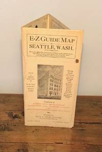
[Seattle - Maps]
E-Z Guide Map of Seattle Wash. With Indicator
Seattle: Seattle Title Trust Company 1926. First Printing. Very Good. Narrow octavo. Six panel fold-out map printed in black and orange with titles and illustration on front panel. A touch of sunning and two light dampstains on two exterior folds non-map side. Now housed in a clear archival sleeve with an acid-free backing. [Seattle Title Trust Company] unknown
Referenz des Buchhändlers : 11632
|
|
|
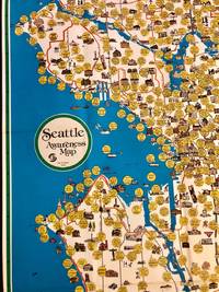
[SEATTLE - Maps]
Scarce Pictorial Map of Seattle - "Seattle Awareness Map
Seattle: City of Seattle 1978. First Printing. Very Good. Anne W. Knight. Single sheet measuring 26.25" x 44.5" 67 x 113 cm folds to 7" x 11" 17 x 28 cm. Color map depicts Seattle's hourglass shape bordered on the west by Lake Washington to the east by Puget Sound. Reverse features a narrative timeline of the city along with historic photos and a key to points of interest. Slight age toning to the folded front and rear covers and some pinholes at intersections of folds. <p>Historical and cultural facets of Seattle are emphasized through idiosyncratic 1970s design excess using cartoon thought-bubbles for commentary. Produced by the city's Department of Community Development under Mayor Charles Royer the map reveals the mores of 1970s culture. For example the map features Seattle City Light's "Solar Powered Home" and "Experimental Wind Generator" harbingers of today's reality along with landmarks some obscure of the city's history. OCLC locates two copies one at the Seattle Public Library the other at the University of Washington.</p> . City of Seattle unknown
Referenz des Buchhändlers : 2072
|
|
|
[SERIZAWA KEIGO]. 芹澤馨吾
標準大東亞分圖・南洋群島 内南洋. Hyojun Daito-A bunzu: Nanyo gunto nai Nanyo. Standard Sectional Map of the Greater East Asia: the South Sea Islands Inner South Sea.
統正社 Tōseisha . Showa 18 1943. Colour folded map 54. x 76.5cm. Pinholes at corners light even browning good copy. This Japanese map of Micronesia shows the Mariana Islands Eastern and Western Caroline Islands Marshall Islands and Gilbert Islands. The separate maps around the edge are clockwise from the upper right corner: Jaluit Atoll Guam Island Rota Island Saipan Island Palau Islands Yap Island Hall Islands Pohnpei Island Truk Islands and Kusaie Island. . 統正社 [Tōseisha ]. unknown
Referenz des Buchhändlers : 155215
|
|
|
[Shell]
CARTE REGIONALE SHELL N° 1 "NORD - BELGIQUE"
Carte géographique, format ouvert 910 x 660 mm, éditée en 1940, bon état
Referenz des Buchhändlers : LFA-126737263
|
|
|
[SHIHAN GAKKŌ] 師範学校編輯.
北亜米利加洲. Kita Amerika-shū. The States of North America.
Kyoto.: 村上勘兵衛 文部省刊行. Murakami Kanbē; Monbushō kankō. Meiji 10 1877. Colour woodblock map of North and Central America. From the Journal of World Geography 萬國地誌略 published in 1877. Printed area measures 33.5 x 21cm a good copy with occasional soiling. . 村上勘兵衛, 文部省刊行. [Murakami Kanbē; Monbushō kanko& unknown
Referenz des Buchhändlers : 159812
|
|
|
[SHIPPING -- MAPS]. ROWAN, JF. (Exec. Secretary). J. F.
Household Goods Carriers’ Bureau agent mileage guide No. 4. Cancels mileage guide No. 3. Containing maps and charts of distances in miles for common contract and passenger carriers between points within the United States also. . . to and from points in Canada and Mexico. . . ; Supplement No. 10. . . cancels Supplement No. 9. . . Effective June 7 1947.
Washington D.C. & Chicago IL: Household Goods Carriers’ Bureau Rand McNally & Co. 1941; 1947. Two vols. 296 pp. including 22 large folding colour maps a few w/ minor toning to fore-edges some dustsoiling a few w/ minor tape repairs especially at a couple folds and near gutter margin. Quarter-green cloth over printed light green softcovers stapled as issued minor soiling some slight foxing & toning still VG copy; 9 3 pp. Stapled as issued minor toning light creasing at corners VG. First edition of this essential HHGCB mileage guide issued just weeks before Pearl Harbor and the entry of the United States into World War II. Originally established in 1936 after the passage of the Reed-Bulwinkle and Interstate Commerce Commission Acts the HHGCB organized to file the required mileage tariffs with the ICC and issued this guidebook. This mileage guide contained maps from the Rand McNally Co. together with charts to determine highway distances between principal points in the United States and allow transport charges to be computed. This guidebook offers an essential snapshot of not only the existing transportation network during World War II but also the vital routes of trucking goods across the country locally or into Canada and Mexico prior to the creation of the Interstate Highway System later authorized in 1956 by President Eisenhower. The supplement updated many of the mileage references following the War acknowledging the tremendous build-up of infrastructure during and in Post-War America. The HHGCB continued to operate in assorted consolidations and mergers until the 2007 decision eliminating all motor carrier rate bureaus. Worldcat locates 1 copy of No. 4 no copies located of Supplement No. 10 US Dept. of Transportation Library. Household Goods Carriers’ Bureau, Rand McNally & Co., paperback
Referenz des Buchhändlers : 56936
|
|
|
[Siebenbürgen] - Tîrgu Mures.
Libera regiaque civitas siculica Maros Vasarhely. Targu Mures, [1822-]1827.
Kupferstich von Samuel Nagy nach Mikolai Tóth Istvan. 415:780 mm. Unter Passepartout. Prachtvolle und großformatige, als Einzelblatt erschienene Gesamtansicht der Stadt Targu Mures (dt. Neumarkt am Mieresch, ungar. Marosvásárhely) in Siebenbürgen. - Bei der in den Jahren 1822-25 entstandenen Ansicht der Stadt aus der Vogelschau handelt es sich um die bis dahin genaueste topographische Aufnahme der Stadt, die bis zum Beginn des 20. Jahrhunderts unübertroffen bleiben sollte. Vorangegangen waren dem vorliegenden Blatt lediglich zwei kleinere und recht ungenaue Veduten von 1736 bzw. 1750; die früheste bei Nebehay/Wagner genannte Ansicht der Stadt datiert überhaupt erst von 1840. Die eingedruckte Legende im unteren weißen Rand benennt die wichtigsten Gebäude und Monumente, dazwischen ein Adler das Stadtwappen haltend. - Breitrandig mit umlaufendem Plattenrand und sehr sauber. Minimale Randläsuren außerhalb des Passepartoutausschnittes fachmännisch restauriert. Von größter Seltenheit. Keresztes Gyula. Marosvásárhely látképe és házsorainak képe Mikolai Tóth István rajzai alapján, Milléniumi megemlékezés, Juventus Kiadó, Marosvásárhely, 2000, SS. 230-237.

|
|
|
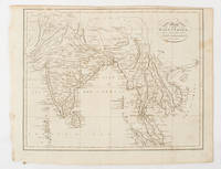
[SOUTH ASIA - MAP]. NEELE, SAMUEL JOHN.
Map of the East Indies from the Best Authorities.
London & Glasgow.: W. and D. Brownlie. 1805. Engraved map 18.7 x 23.9 cm original folds age toned and spotted inner margin a trifle ragged paper thinning in a few spots in good condition. Attractive map engraved for "A System of Geography; or A Descriptive Historical and Philosophical View of the Several Quarters of the World" published in 1805. . (W. and D. Brownlie) unknown
Referenz des Buchhändlers : 175148
|
|
 Per e-mail erhalten
 Als pdf-Dokument herunterladen
 RSS feed


