|
BARRAS Paul; DURUY George (intro):
Mémoires de Barras, membre du directoire.
Paris, Lib. Hachette, 1895-1896. 4 volumes in-8 de LXXXIII-372 / XVI-543 / XXXVI-526 et XXXII-548 pages, demi-percaline bordeaux, dos lisses, étiquettes de titre brunes, un brin frottées, couvertures conservées.
Referenz des Buchhändlers : 1723

|
|
|
BARROW, John.
Nouveau voyage dans la partie méridionale de l'Afrique....
Dentu, Imprimeur - Libraire, Paris, 1806, 2 volumes in-8 , x-310pp. ,2ffnch.-312pp. ,illustré de 8 cartes dépliantes , relié plein cuir époque , dos lisse avec pièce de titre rouge et tomaison noire , tranches mouchetées bleues , coupes et coins usés , début de fentes , rares rousseurs , frottements.
Referenz des Buchhändlers : PHO-1285

|
|
|
BARKER Ronnie
Pennyworth of Art : the Green album -- his own collection of picture Postcards.
The Herbert press, 1986. Grand in-8 carré relié, avec jaquette imprimée en couleurs, 96 pages, richement illustré en couleurs, très bon état. /// the Herbert Press, London, 1986. Hardcover. État : Very Good. Etat de la jaquette : Very Good. Photographic (illustrateur). 1st Edition. 550 g; 96 pages of postcards with an introduction and attendant commentary on each card. Colour illustrated dust wrapper is very slightly faded on the spine section, and the Green papered boards are slightly rubbed on the bottom edge.
Referenz des Buchhändlers : 18587

|
|
|
BARTHÉLEMY (J.E.).
Plan géométrique (en deux feuilles) des bois dépendants du domaine de Tigery appartenants à Madame de Clermont-Tonnerre. Dressé par J.E. Barthélemy, géomètre à Corbeil, d'après les réarpentages successifs faits depuis 1843 inclusivement (à l'exception de l'année 1851).
1864. In-folio ; demi-percaline noire, dos lisse muet, pièce de titre de maroquin rouge sur le premier plat (reliure de l'époque).
Referenz des Buchhändlers : LBW-6635

|
|
|
BARBIÉ du BOCAGE, J.D.:
Plan de L’ Hellespont, de la Chersonèse de Thrace et d une grande partie de la Troade. Pour le Voyage du Jeune Anacharsis. Gravé par P.F. Tardieu / L. Aubert scripsit (les textes).
1782 - Germinal An VI, 34x23 cm, carte sous passepartout.
Referenz des Buchhändlers : 130920aaf
|
|
|
BARTHELEMY (Jean-Jacques).
Voyage du jeune Anacharsis en Grèce & Recueil de cartes géographiques, plans, vues, médailles de l'ancienne Grèce.
A Paris, chez E. A. Lequien / de l'Imprimerie de P. Didot l'Aîné, 1822 - A Paris, chez de Bure, 1839 (pour le volume d'Atlas). 7 vol. de texte au format in-8 (225 x 141 mm) de 1 f. bl., 2 ff. n.fol., 1 frontispice gravé n.fol., 451 pp. et 1 f. bl. ; 1 f. bl., 2 ff. n.fol., 488 pp. et 1 f. bl. ; 1 f. bl., 2 ff. n.fol., 462 pp., 1 f. n.fol. et 1 f. bl. ; 1 f. bl., 2 ff. n.fol., 474 pp., 1 f. n.fol. et 1 f. bl. ; 1 f. bl., 2 ff. n.fol., 466 pp., 1 f. n.fol. et 1 f. bl. ; 1 f. bl., 2 ff. n.fol., 423 pp., 1 f. n.fol. et 1 f. bl. ; 1 f. bl., 2 ff. n.fol., 438 pp., 1 f. n.fol. et 1 f. bl. 1 vol. d'Atlas au format pt in-4 (282 x 223 mm) de xlii pp et 31 planches gravées, sous couverture d'attente de l'époque de plein cartonnage gris-perle.
Referenz des Buchhändlers : 19077

|
|
|
Barabas, Ildiko
Carte vom Hochadelichen Gute Wandsbeck und der dazu gehörige Meierhof Mühlenbeck den Dörfern Hinschenfelde Tonnendorf et Lohe. NACHDRUCK nach einer kolorierten Zeichnung von Lorentz Heinrich Boysen, anno 1805.
Braunschweig, Archiv-Verlag, [ca. 1985]. Mehrfachk gefalt. farb. Karte (Blattgröße ca. 48 x 83 cm; Bildgröße ca. 44 x 78 cm).
Referenz des Buchhändlers : 99384
|
|
|
Barbara Abbs Author; Susan Rowland Maps by
French Gardens: A Guide
Sagaponack NY: Sagapress Inc. 1995. Book. Illus. by Deidre Hall Photographs by; Susan Rowland Maps by. Like New. Trade Paperback. 8vo or 8° Medium Octavo: 7¾" x 9¾" tall. 173 pp. Very clean book with minor creasing on spine. Solid and tight binding. Two small stains on top edge. Sagapress, Inc. Paperback
Referenz des Buchhändlers : 1ivEc0017 ISBN : 0898310415 9780898310412

|
|
|
Barbara Anthony & Marcillene Barnes, (Illustrated By Kreigh Collins in B/W ) Maps Drawn By Harold Vander Werf, Inner Flap DJ Pr
Explorers All Story of Adventures & Achievements for Boys & Girls & Adults Includes Norsemen Marco Polo Christopher Columbus Vasco Da Gama Hernando De Soto Henry Hudson Robert Cavelier De La Salle David Livingstone Robert Edwin Peary
Fideler MICH 1942 HBDJ 1942. 1st EditionGoldenyellow cloth hardback cvr duplicates DJ Illustration. size= 8 1/4 x 9 1/2 in. 112 pgs Oblong illustrated cloth Light handling soil on back cover of book and back cover of dustjacket light corner and spine ends wear on dustjacket. NOT x-lib. Very Good in Very Good Dustjacket. DJ light rub wear tiny chips tears extremities. First Edition. Hard Cover. Fideler MICH hardcover
Referenz des Buchhändlers : 26040
|
|
|
Barbara Kingsolver; Rebeca Cartes
Another America/Otra America
Seattle: Seal Press 1992. First Edition . Hardcover. Fine/Near Fine. Fine in near fine dust jacket with light rubbing. <br/> <br/> Seal Press hardcover
Referenz des Buchhändlers : b17993 ISBN : 1878067141 9781878067142

|
|
|
Barber, Peter (Commentary)
King Henry's Map of the British Isles
A book on the early map of Great Britain and Ireland forming part of the collection assembled by the antiquary and administrator Sir Robert Cotton. 158 pages. With Notes. In slip-case. Slipcase has some light wear.
|
|
|
BARBEY Antonio (attivo tra il 1690 ed il 1714 circa)
Nuova Pianta della Citta di Roma coll'Indice de Tempij Palazzi et Altre Fabriche Antiche e Moderne...
Mappa di Roma del XVII secolo, incisa a Roma da Antonio Barbey e pubblicata da Domenico de Rossi.Si basa sulla grande pianta murale di Giovan Battista Falda, ma mostra con particolare cura gli interventi urbani sotto il pontificato di papa Innocenzo XII, tra i quali la dogana di mare a Ripa Grande (1694). Sono inoltre contenute nella pianta una serie di interessanti note e i nomi delle ville e vigne entro le mura della città.Comprende un elegante cartiglio con titolo e stemma in alto, e un secondo cartiglio con un lungo elenco che individua 464 luoghi di interesse nella Città Eterna.La mappa è orientata a nord-est in alto e comprende siti antichi e moderni. "I lotti edificati sono campiti con puntinato e vengono indicati i nomi di molte strade. L'impostazione generale e vari dettagli denotano la derivazione di questa pianta dalla grande del Falda cui il Barbey apportò però numerosi aggiornamenti. Sono infatti riportati i nuovi interventi di Innocenzo XII tra i quali la dogana di mare a Ripa Grande (1694). Sono inoltre contenute nella pianta una serie di interessanti note e i nomi delle ville e vigne entro le mura della città. In basso a sinistra è scritto Ant. Barbey Sculp. ed a destra Domenico de Rossi [...] l'anno 1697 il di 25 maggio. Sotto il titolo in alto è riportata la dedica a Mons. Ranuccio Pallavicino Governatore di quest'alma Città e vice Camerlengo [...] Innocenzo XII felicemente regnante. Sui due lati legenda con 464 numeri di rimando ed elenco dei XIV rioni, e, in basso a destra, l'indice delle chiese di Roma" (cfr. Marigliani p. 253). Incisione in rame con bellissima coloritura a mano, alcune pieghe di carta perfettamente restaurate, per il resto in buono stato di conservazione. Rara. Bibliografia Frutaz n. 162, Scaccia Scarafoni n. 206, Huelsen n. 135; Marigliani n. 159. Map of Rome from the 17th century, engraved in Rome by Antonio Barbey and published by Domenico de Rossi. It is based on the large wall map by Giovan Battista Falda, but shows with particular care the urban interventions under the pontificate of Pope Innocenzo XII, including the sea customs house at Ripa Grande (1694). The map also contains a number of interesting notes and the names of the villas and vineyards within the city walls. It includes an elegant cartouche with title and coat of arms at the top, and a second cartouche with a long list identifying 464 places of interest in the Eternal City. The map is oriented north-east at the top and includes ancient and modern sites. Built-up lots are dotted and the names of many streets are indicated. The general layout and various details indicate that this map derives from Falda's great map, to which Barbey however made numerous updates. In fact, the new interventions of Innocent XII are shown, including the sea customs house at Ripa Grande (1694). The map also contains a series of interesting notes and the names of the villas and vineyards within the city walls. At lower left is written Ant. Barbey Sculp. and on the right Domenico de Rossi [...] the year 1697 the 25th of May. Under the title at the top there is the dedication to Monsignor Ranuccio Pallavicino Governor of this great City and Vice Camerlengo. On both sides a legend with 464 reference numbers and a list of the XIV districts, and, at the bottom right, the index of the churches of Rome (cf. Marigliani p. 253). Copper engraving with fine later hand colour, few repaired paper folds, otherwise in good condition. Rare. Bibliografia Frutaz n. 162, Scaccia Scarafoni n. 206, Huelsen n. 135; Marigliani n. 159.

|
|
|
Barcelona Popout Map Popout Maps Maps
Barcelona Popout Map Popout
Good. There is residue from a price sticker on the front cover. The maps are cleana nd unmarked. unknown
Referenz des Buchhändlers : pb04bpom ISBN : 1845878590 9781845878597
|
|
|
Barker, Felix
London from the Air
No marks or inscriptions. A very clean crisp very tight copy with bright unmarked boards and no bumping to corners. Dust jacket not price clipped or marked or torn or creased with light traces of storage. 144pp.

|
|
|
Barlow, Frank ; maps, Neil Hyslop
William Rufus background and Youth -- The Kingdom Obtained 1087-1088 -- The Bachelor King and his Domestic Servants -- The Nobility and Higher Clergy and the Royal Government -- The Sinews of War -- The Three Brothers 1088-1095 -- The Conquering Hero 1094-1100 -- Death in the Afternoon 1100 -- Epilogue -- Appendices: The Children of William I and Matilda -- William IIs Sheriffs -- Select bibliography -- Genealogical tables
Berkeley and Los Angeles : University of California Press 1983 1983. 1st Edition 1st Printing. Hardcover. Fine/Fine. xix 484 pages 16 pages of plates : illustrations ; 24 cm. ; ISBN 9780520049369 0520049365 OCLC 8954468 LCCN 82045902 LC DA197.5 .B37 1983 ; Dewey 942.02/2/0924 ; William II better known as William Rufus was the third son of William the Conqueror and England's king for only 13 years 1087-1100 before he was mysteriously assassinated. In this vivid biography here updated and reissued with a new preface Frank Barlow reveals an unconventional flamboyant William Rufus-a far more attractive and interesting monarch than previously believed. Weaving an intimate account of the life of the king into the wider history of Anglo-Norman government Barlow shows how William confirmed royal power in England restored the ducal rights in France and consolidated the Norman conquest. A boisterous man William had many friends and none of the cold cruelty of most medieval monarchs. He was famous for his generosity and courage and generally known to be homosexual. Licentious eccentric and outrageous his court was attacked at the time by Anselm archbishop of Canterbury and later by censorious historians. This highly readable account of William Rufus and his brief but important reign is an essential volume for readers with an interest in Anglo-Saxon and medieval history or in the lives of extraordinary monarchs. ; black cloth in color pictorial dustjacket ; ownership stamp ; foxing else FINE/FINE <br/> <br/> Berkeley and Los Angeles : University of California Press, 1983 hardcover
Referenz des Buchhändlers : 009114 ISBN : 0520049365 9780520049369
|
|
|
Barnes, Jeremy
The Pictorial History of the American Civil War
208 pages including index. From the first firing of guns at Fort Sumter to the ultimate surrender of the South, richly illustrated with many contemporary engravings and rare photographs as well as many colour illustrations and maps. A must for every Civil War Buff. Clean and unmarked. Very light wear. Gorgeous copy of this handsome work. Book
|
|
|
Barnett's Maps
Bedford Street Plan with Index with Road Map of Bedfordshire and Plan of Car Parks & One-Way Streets
Barking: G.I. Barnett & Son. No date 1970s folded map with some red ink hi -liting. . Good. Paperback. G.I. Barnett & Son paperback
Referenz des Buchhändlers : 153011
|
|
|
Barnett, A. Doak; End Paper Maps [Illustrator]
COMMUNIST CHINA AND ASIA CHallenge to American Policy. Council on Foreign Affairs Study
Harper & Brothers 1960-01-01. Hardcover. Very Good. 0x0x0. Hardcover. Very Good in Very Good dust jacket. Clean tight. Name inside. Harper & Brothers hardcover
Referenz des Buchhändlers : UT1513415

|
|
|
BARNEVILLE
Carte couleurs au 1/100 000?. Feuille VIII-11. Mise ? jour 1923.
Une feuille 57x45 cm.
|
|
|
Baron Jean Thiry et Avec 6 Cartes
La Campagne de Russie SIGNE
Berger-Levrault 1969. Paperback. Good. Slightly creased cover. Slight signs of wear on the cover. Stains on the edge. Different cover. Ammareal gives back up to 15% of this item's net price to charity organizations. Berger-Levrault paperback
Referenz des Buchhändlers : E-810-823
|
|
|
Baron, Stanley
The Road to Rome
No marks or inscriptions. A very clean very tight copy with bright unmarked boards and no bumping to corners. Dust jacket not price clipped or marked, torn or creased with a little rubbing to bottom of spine. 307pp. The author follows a route from Boulogne by way of Reims, Colmar, Lucerne, the St Gotthard Pass, Milan, Lake Maggiore, Cremona, Ravenna, Florence and finally Rome where he continues his tour.

|
|
|
BARRERE, Henry ; ANDRIVEAU-GOUJON
Empire Ottoman [ Carte de l'Asie Mineure - 1904 ]
Carte entoilée en couleur au format 94 x 68 cm, échelle 1 : 3500000, Maison Andriveau-Goujon, Henry Barrère, Paris, 1904 (mention rev. 1904), carte n° 15, atlas usuel n° 21 ; atlas universel n° 34, gravé : le trait par Smith, la topographie par Gérin, les Ecritures par Rousset, les Eaux par Mme Fontaine Belle grande carte entoilée de l'Empire ottoman (petites usures aux pliures, une petite annotation marginale). Français

|
|
|
Barrett, Betty and Power, Frances
The Golden Book of Dublin
No inscriptions or marks. No creasing to covers or to spine. A very clean crisp tight copy with bright unmarked boards, very slight traces of handling and no bumping to corners. 64pp. A brief history of Dublin, a guide and map to the city.

|
|
|
Barron, Roderick
Decorative Maps
London: Bracken Books poster art series 1989. Fine. <p>Folio 28X38cm 8p 40 color plates ill covers</p> Bracken Books, poster art series unknown
Referenz des Buchhändlers : biblio638 ISBN : 1851702989 9781851702985
|
|
|
Bartholemew Maps
Bartholemews Contoured Road Map of the British Isles
Edinburgh: John Bartholemew & Sons 1961. Folding color map scale 1: 1000000. Good Plus unmarked bright w a few small tears at the fold points one clean 7-inch corner tear some tape scars at top. All tears easily repairable. A vintage color-contoured view of Britain. 35 x 40. Scarce. <br/><br/> John Bartholemew & Sons unknown
Referenz des Buchhändlers : 4556
|
|
|
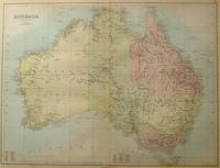
BARTHOLOMEW, J.
Australia.
Edinburgh.: A & C Black. 1884. Printed colour map of Australia some light foxing few minor tears browned edges still a clear and bright image. Map measures approximately 42 x 55cm. . A & C Black unknown
Referenz des Buchhändlers : 56997
|
|
|
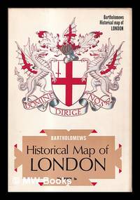
Bartholomew's historical maps
Bartholomew's historical map of London
London : S.I. 1969. 1st edition. Softcover. Very good map folded in stiff-card wrappers. Physical description; 1 map Illus. white card 10"". Subjects; LONDON/MIDDLESEX - GENERAL:MAPS. London. Middlesex. London : S.I. paperback
Referenz des Buchhändlers : 423629
|
|
|
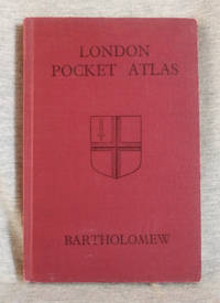
Bartholomew, John and Son
London Pocket Atlas
Edinburgh: John Bartholomew and Son 1947. Hardcover. Very Good/no jacket. Red cloth with black title 37 pages of street maps 81-page index to streets and buildings 7-in tall. Includes supplementary index to street name changes. Street maps show location of railways and underground. A clean copy with minor wear to the covers. John Bartholomew and Son hardcover
Referenz des Buchhändlers : 002358
|
|
|
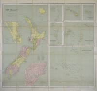
BARTHOLOMEW, J.
New Zealand. Philips's Series of Travelling Maps. Polynesia - Sheet title.
London.: George Philip & Son. 1865. 9 coloured maps by William Hughes segmented and mounted on linen 55.3 x 65.2cm. Folds into cloth covered case 17.2 x 12cm. Spine of case little faded and ribbon tie missing. Relief shown by hachures and spot heights. Philips' series of travelling maps series. Very good copy. Features a dominant map of New Zealand with 3 maps as insets to this map and 6 other maps separately shown within their own borders. The 3 inset maps are: Norfolk Island and Philip Island; Enlarged map of Auckland and the adjacent country; Enlarged plan of the country around Dunedin and the eastern portion of the Otago Gold Fields from Thomson's map. <br> <br>The 6 maps in addition to the New Zealand map are The Ladrones or Mariana Islands; The Sandwhich Islands; The Galapagos Islands; The New Hebrides and Santa Cruz Islands; The Feejee Friendly and Samoan Islands; The Marquesas Society and Low Archipelago. <br> <br>The New Zealand maps includes a list of native tribes and their locations. . George Philip & Son. hardcover
Referenz des Buchhändlers : 154409
|
|
|
Bartholomew John (Maps)
The Comparative Atlas of Physical and Political Geography. 24th Edition
Meiklejohn & Son Ltd 1934-01-01. Hardcover. Acceptable. 0.9992 in x 27.9787 in x 21.9833 in. Ex-library book usual markings. Well read with some wear but still very useable. Broken spine does not affect reading good for its age. Meiklejohn & Son Ltd hardcover
Referenz des Buchhändlers : mon0000301234
|
|
|
Bartholomew, John G [maps]
The Times Comprehensive Atlas of the World Twelfth Edition
London 2008. Slipcased. as New. Bartholomew John G maps. Used - VG: in very good condition with slipcase Hardcover ISBN 13 9780007801503 ISBN 10 0007801505 <br /> The Times Book Group. Illustrated hardback laminated board cover. 460mm x 320mm 18" x 13". 67pp 224pp plates. Colour maps. Heavy item - shipping supplement will apply for overseas. . <br/><br/> unknown
Referenz des Buchhändlers : 3278 ISBN : 0007801505 9780007801503

|
|
|
Bartholomew
Bartholomew's Quarter Inch Map of Ireland : Sheet 4 - Cork and Killarney
No marks or inscriptions. Two secitions slightly sunned. A little tearing along most exposed vertical fold. Some exposure of the linen but still intact along some other folds. 1pp. Folded linen-backed vintage map of Cork and Killarney opens up to 23 x 33 inches. Undated ca 1950s. Compass north bearing date 1948.
|
|
|
Bartholomew
Bartholomew's Quarter Inch Map of Ireland : Sheet 5 - Galway - Mayo
No marks or inscriptions. A little very slightl sunning. Intact map with no tears. 1pp. Folded linen-backed vintage map of Galway and Mayo opens up to 23 x 33 inches. Undated ca 1950s. Compass north bearing date 1951.
|
|
|
Bartholomew
World travel map Israel with Jordan. Scale 1:350000.
Bartholomew, Edinburgh 1971. Farbige gefaltete Karte. Ca. 66 x 86 cm (bxh). Geringe Gebrsp.
Referenz des Buchhändlers : 10980
|
|
|
BARTHOLOMEW'S RAILWAY MAP.
Bartholomew's Railway Map of the British Isles showing the New Grouping. Each Group distinuished by a Separate Colour. [Scale Nineteen Miles to One Inch.] BRIGHT, CLEAN COPY
8vo., folding coloured map on cloth measuring 34.5 x 29 inches (approx. 88 x 74 cms) folding in 24 panels to 9.5 inches (approx. 23 x 13 cms); wrappers lettered in red and black, certain folds neatly reinforced, some mild age-soiling and rubbing else a very good, bright, clean copy. VERY SCARCE IN THIS CONDITION.
|
|
|
BARTRAM, William
Voyage dans les parties sud de l’Amérique septentrionale
In -8°, due volumi, pp. 457 con due tavole ripiegate, pp. 436 con 1 tavola ripiegata e grande carta geografica pieghevole a cura di J.B. Poirson e stampata da Blondeau, legatura in pelle, con tasselli e titolo al dorso. Nel secondo volume manca la quarta tavola ripiegata, tavola non presente in tutti gli esemplari (v. Stafleu & Cowan, 329 ed. fr.); all’antiporta del primo vol. illustrazione con Mico Chlucco, il Gran Guerriero o il Re dei Seminole. Prima edizione francese. Particolarmente dettagliata la carta geografica, importante per capire il livello di accuratezza raggiunto dalle esplorazioni scientifiche. In -8°, two volumes, pp. 457, with two large folded plates, pp. 436 with 1 folded plate and large folded map by J.B. Poirson and engraved by Blondeau, leather binding with title at the back. In the second volume the fourth folded plate is missing which is not existing in each copy, (see Stafleu & Cowan, 329 ed. fr.). At the frontispice of the first volume portrait of Mico Chlucco, the Great Warrior or the King of Seminoles. First French edition.
|
|
|
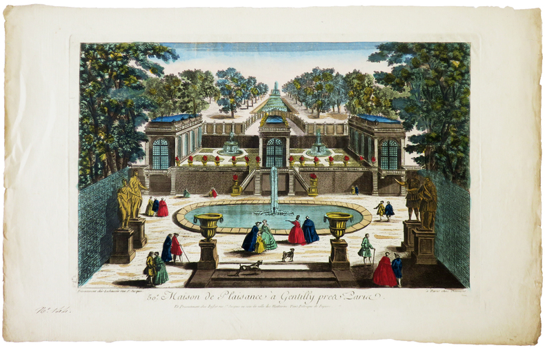
BASSET (Paul André).
[GENTILLY] 50e. Maison de plaisance à Gentilly près Paris.
Paris, Daumont, Lachaussée puis Basset, [circa 1780]. 270 x 395 mm.
Referenz des Buchhändlers : LBW-6270
|
|
|
BASSET (Paul André).
[JEU de l'OIE] Nouveau Jeu historique et chronologique de la Monarchie française.
Paris, Basset, [1815]. 454 x 605 mm.
Referenz des Buchhändlers : LBW-8528

|
|
|
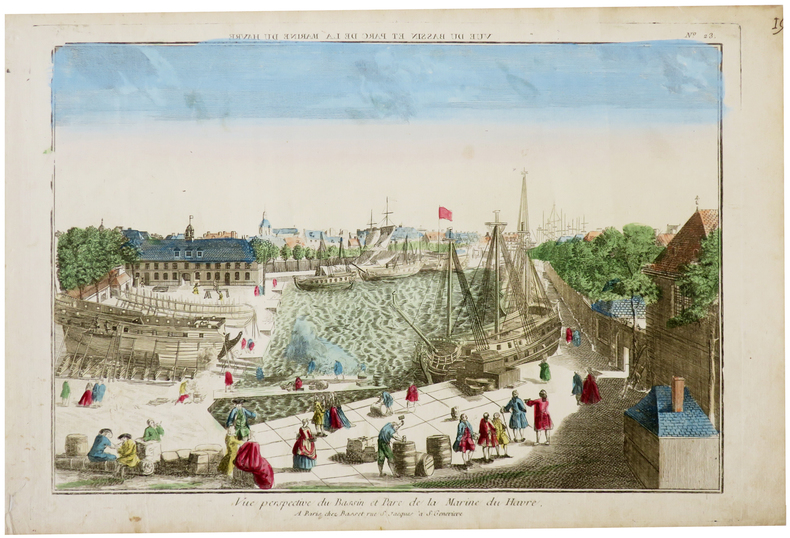
BASSET (Paul André).
[LE HAVRE] Vue perspective du bassin et parc de la Marine du Havre.
Paris, Basset, [circa 1760]. 286 x 398 mm.
Referenz des Buchhändlers : LBW-6286
|
|
|
BASSET (André).
[NOTRE-DAME de PARIS] Vue perspective de l'intérieur de l'église de Notre Dame de Paris.
[circa 1780]. 280 x 390 mm.
Referenz des Buchhändlers : LBW-5770

|
|
|
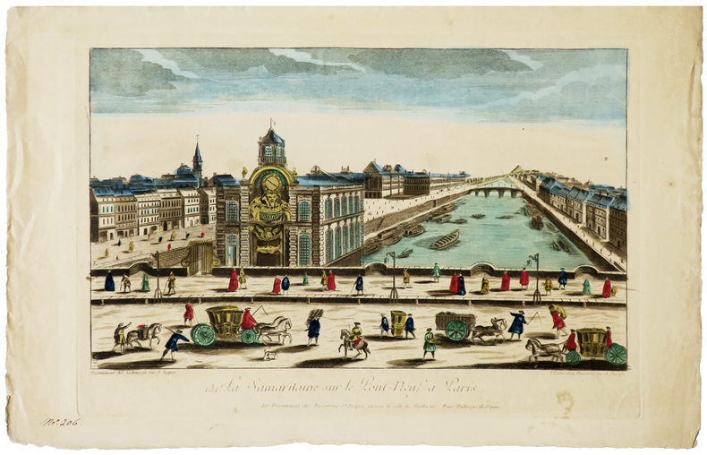
BASSET (Paul André).
[SAMARITAINE] 131e. La Samaritaine sur le Pont-Neuf à Paris.
Paris, Daumont, Lachaussée puis Basset, [circa 1780]. 284 x 420 mm.
Referenz des Buchhändlers : LBW-6280
|
|
|
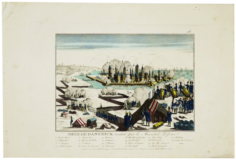
BASSET (Paul André).
[SIÈGE de GDANSK] Siège de Dantzick conduit par le maréchal Lefèvre.
Paris, Basset, [1807]. 170 x 197 mm.
Referenz des Buchhändlers : LBW-5965
|
|
|
BASSET (Paul André).
Carte de la France tracée d'après les nouvelles limites fixée par le Traité de Paix du 20 novembre 1815.
Paris, Basset, 1816. 477 x 680 mm.
Referenz des Buchhändlers : LBW-3688

|
|
|
Basse Seine
carte Basse Seine au 1/10 000e de Paris a Rouen
IN4 1950,2e edition,carte coloriée depliante en accordeon d’un sel tenant de Bougival a Tourville(Rouen),tres rare,complet,pres de 100Km de berges,
Referenz des Buchhändlers : 17045
|
|
|
BASSIN HOUILLER DE L’AVEYRON
Concession de MAZEL, BASSIN HOUILLER DE L’AVEYRON, documents historiques originaux
1860 S.L.,S.d.,vers 1859 / 1860;IN4 broché,texte en lithographie manuscrite : 23p.+ plans et cartes dont trés grande carte dépliante coloriée des lignes de chemins de fer de l’epoque,1- coupe synthétique du bassin houiller d’Aubin a Decazeville,1bis-coupe geologique, 2- carte geologique dépliante du bassin, 3-profil de la grande couche du MAZEL depliante,4- trés grande carte dépliante coloriée des lignes de chemins de fer de France de l’époque avec légendes manuscrites,
Referenz des Buchhändlers : 21459

|
|
|
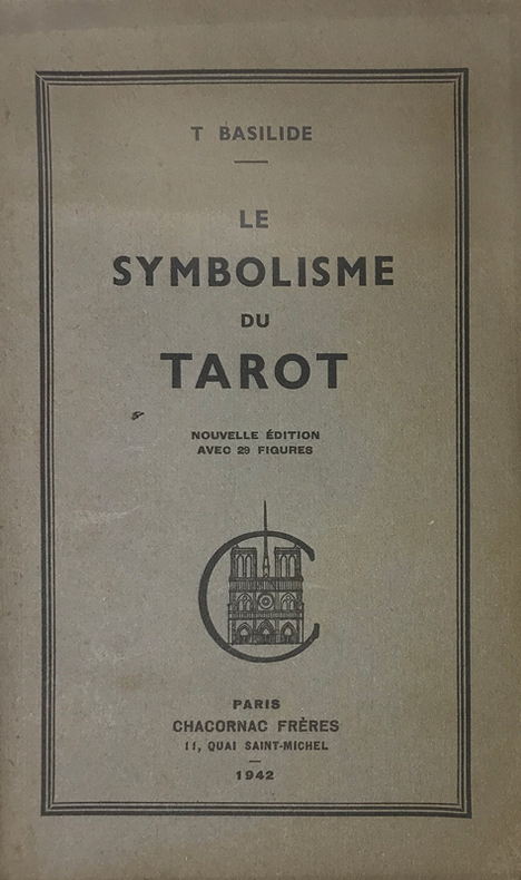
Basilide (Patrice Genty, 1883-1964, consacré évêque de l'Eglise Gnostique sous le nom de Taur) :
Symbolisme (Le) du Tarot. Nouvelle édition avec des figures.
Paris, Chacornac, 1942 ; in-8, brché ; (1) f. blanc, 53, (1) pp., couverture vert-olive imprimée en vert foncé.
Referenz des Buchhändlers : 15259
|
|
|
BASEQUE L.
Construction des cartes de l'?tat-major (en Fran?e et en Belgique) et coordon?es rectilignes. Calculs tr?s simple des distance ? vol d'oiseau. A l'usage de l'enseignement, l'a?rostation, l'aviation et la colombophilie.
Broch?. 71 pages.
|
|
|
BASSET
Rome
Questo panorama di Roma risulta essere una copia di quello edito da Chereau intorno al 1730 circa. L’assenza del porto di Ripetta e della scalinata di Trinità dei Monti permette di datare il paesaggio ritratto al 1700 circa. La raffigurazione di San Pietro ricorda quella del Barriere che è forse da ritenersi il lontano prototipo di questa serie di vedute edite in Francia nel XVIII secolo.Di questa incisione è nota una variante, censita da Marigliani, che reca in basso l’indirizzo di François Basset, e la cui edizione risale al 1780 circa.È quindi possibile suppore che questo sia il primo stato della lastra, avanti l’indirizzo editoriale, oppure che Basset abbia successivamente acquisito il rame e pubblicato con l’aggiunta del proprio indirizzo.Incisione in rame, finemente colorata d'epoca, in basso tre righe di testo in francese e legenda numerica 1-16, in ottimo stato di conservazione. This panoramic view of Rome is a copy of the one published by Chereau around 1730 or so. The absence of the port of Ripetta and the stairway of Trinità dei Monti allows us to date the landscape portrayed to around 1700. The depiction of Saint Peter recalls that of the Barriere which is perhaps to be considered the prototype of this series of views published in France in the eighteenth century.Marigliani describes a copy bearing the address of François Basset below, and whose edition dates back to around 1780.It is therefore possible to suppose that this is the first state of the plate, before the editorial address, or that Basset has subsequently acquired the plate and then published it with the addition of his own address.Copper engraving, finely colored at the time, three lines of text in French at the bottom and numerical key 1-16, in excellent condition. C. Marigliani, "Le Piante di Roma delle collezioni private", tav. 174 (variante)

|
|
|
Bassett, Thomas J.; Seager, Joni; Rokeach, Barrie; Horowitz, Helen Lefkowitz; Nemeth, David; Ricciotti, Dominic; Todhunter, Rodger; Ford, Larry R.; griffin, Ernst
Landscape, Volume 25, Number 2, 1981
48 pages. Features: Reaping on the Margins; - a century of community gardening in America; Push Over, Paradigm; Light Winds Aloft; Seeing Ourselves Through The Bars - A Historical Tour of American Zoos; 'Bright Yard' Maps from Cheju Island; Symbols and Monuments - Images of the Skyscraper in American Art; Banff and The Canadian National Park Idea; Chicano Park - Personalizing an Institutional Landscape. Moderate wear. Unmarked. A sound copy. Book

|
|
|
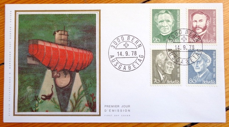
Bathyscaphe. Abbé Bovet - Henri Dunant - Carl G. Jung - Auguste Piccard:
Enveloppe philatélique.
Studio philatélique G. Marchand, 1978. Enveloppe au format 16,6 x 9 cm., ornée d'une belle vignette en soie représentant le Bathyscaphe et d'un bloc de 4 timbres, affranchissement philatélique, premier jour d'émission. A l'état de neuf.
Referenz des Buchhändlers : 4857
|
|
 Per e-mail erhalten
 Als pdf-Dokument herunterladen
 RSS feed


