|
BECKER, F.:
Die schweizerische Kartographie im Jahre 1914, Landesausstellung in Bern. Wesen u. Aufgaben einer Landesaufnahme. (S.-A. aus: Schweiz. Zeitschrift für Artillerie u. Genie)
Frauenfeld: Huber, 1915, in-8vo, 87 S., unaufgeschnitten, Original-Broschüre. Umschlag knitterig.
Referentie van de boekhandelaar : 126360aaf
|
|
|
BECKER-CARUS (Ewald).
[TERRE SAINTE] Carte illustrée de l'Ancien Testament.
Hambourg, Éditions Ewald Becker, [circa 1950]. En 4 feuilles jointes formant une carte de 1,70 x 1,66 m ; montée sur toile, entre deux baguettes de bois avec liens de cuir.
Referentie van de boekhandelaar : LBW-7220

|
|
|
Beckmann, Otto
Orts-Verzeichnis zur Spezial-Post- u. Eisenbahnkarte des Deutschen Reiches. Bearb. von Otto Beckmann. Rev. von Gustav Müller.
Stuttgart, Klemm und Beckmann, [ca. 1905]. 210 S. Gr.-8vo. 23,5 cm. OHLn. m. gold- u. schwarzgeprägtem VDeckel.
Referentie van de boekhandelaar : 89526

|
|
|
Beckmann, Otto
Special-Post- und Eisenbahnkarte des Deutschen Reiches. Bearb. von Otto Beckmann. Rev. von Gustav Müller. SECTION 1, 3 und 4 (von 4).
Stuttgart, Klemm und Beckmann, [ca. 1905]. Jeweils ein farbiger Faltplan (178 x 143 cm). Gr.-8vo. 23,5 cm. OKart. m. gold- u. schwarzgeprägtem VDeckel.
Referentie van de boekhandelaar : 89469

|
|
|
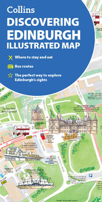
Beddow, Dominic,Collins Maps
Discovering Edinburgh Illustrated Map Collins Travel Guides
Collins 29/03/2012 00:00:01. map. Good. 0.5076 in x 20.3046 in x 10.9137 in. Collins unknown
Referentie van de boekhandelaar : mon0000495543 ISBN : 0007464533 9780007464531

|
|
|
Beddow, Dominic,Collins Maps
Discovering Edinburgh Illustrated Map
Collins 07/04/2016 00:00:01. map. Very Good. 0.5995 in x 20.2846 in x 11.2914 in. Collins unknown
Referentie van de boekhandelaar : mon0000492802 ISBN : 0008136637 9780008136635

|
|
|
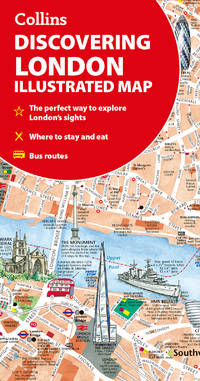
Beddow, Dominic Collins Maps
Discovering London Illustrated Map
like new. unknown
Referentie van de boekhandelaar : 47730209 ISBN : 0008724652 9780008724658
|
|
|
Beddow, Dominic Collins Maps
Discovering London Illustrated Map
new. unknown
Referentie van de boekhandelaar : 47730209-n ISBN : 0008724652 9780008724658
|
|
|
Beddow, Dominic Collins Maps
Discovering London Illustrated Map
Harpercollins Publishers 2025. Sheet Map Folded. New. 2 pages. 4.02x0.24x7.80 inches. Harpercollins Publishers unknown
Referentie van de boekhandelaar : __0008724652 ISBN : 0008724652 9780008724658
|
|
|
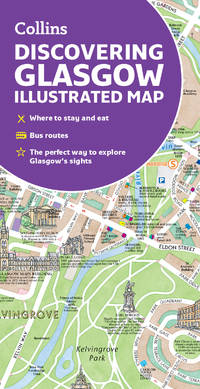
Beddow, Dominic & Collins Maps
Discovering Glasgow Illustrated Map: Ideal for exploring
Collins. Second edition. Map. Used; Very Good. Simply Brit welcome to our online used book store where affordability meets great quality. Dive into a world of captivating reads without breaking the bank. We take pride in offering a wide selection of used books from classics to hidden gems ensuring theres something for every literary palate. All orders are shipped within 24 hours and our lightning fast-delivery within 48 hours coupled with our prompt customer service ensures a smooth journey from ordering to delivery. Discover the joy of reading with us your trusted source for affordable books that do not compromise on quality. 02/08/2018 Collins unknown
Referentie van de boekhandelaar : 3675073 ISBN : 0008266913 9780008266912

|
|
|
Beddow, Dominic/ Collins Maps
Discovering Edinburgh Illustrated Map: Ideal for exploring
Collins 2024. Map. New. 2 pages. 4.53x0.32x7.80 inches. Collins unknown
Referentie van de boekhandelaar : __0008663475 ISBN : 0008663475 9780008663476
|
|
|
Beddow, Dominic/ Collins Maps
Discovering Glasgow Illustrated Map: Ideal for exploring
Collins 2023. Map. New. third edition edition. 2 pages. 8.07x4.45x0.20 inches. Collins unknown
Referentie van de boekhandelaar : __0008602905 ISBN : 0008602905 9780008602901
|
|
|
Bedini, Silvio A.; Photographs & Maps [Illustrator]
The Life of Benjamin Banneker
Charles Scribners 1972-01-01. Hardcover. Like New. 7x5x1. Pristine Hardcover in Fine dust jacket. Clean tight and square. Appears to be unused. Prompt shipping from Colorado. Choose Expedited/Priority 2-6 days.~ "Buy with Confidence Satisfaction Guaranteed! Charles Scribners hardcover
Referentie van de boekhandelaar : 56368
|
|
|
Bee Jay
Scotland's Shangri-La
No marks or inscriptions. A very clean very tight copy with bright unmarked pale green boards, slight bumping to lower page corners and no bumping to board corners. Dust jacket not price clipped or torn with slight marking and very minor creasing to edges. 359pp. The far north-west of Scotland in Wester Ross and Sutherland.

|
|
|
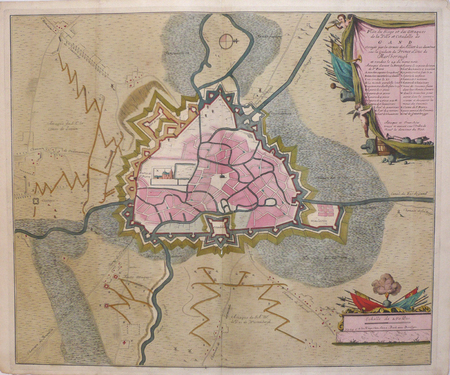
BEECK (Anna);
[GAND] Plan du siège et des attaques de la ville et citadelle de Gand.
La Haye Anna Beek circa 1710 488 x 586 mm.
Referentie van de boekhandelaar : LBW06229
|
|
|
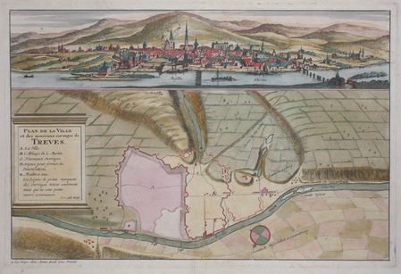
BEECK (Anna);
[TREVES] Plan de la ville et des nouveaux ouvrages de Treves.
La Haye Anna Beek circa 1710 244 x 370 mm.
Referentie van de boekhandelaar : LBW0622b
|
|
|
BEEVERELL James:
Les délices de la Grand’ Bretagne, & de l’Irlande; Où sont exactement décrites les Antiquitez, les Provinces, les Villes, les Bourgs, les Montagnes, les Rivières, les Ports de mer, les Bains, les Forteresse, Abbaies,...
A Leide, Chez Pierre Vander, 1727. 7 vol. (sur 8) in-8 de 1506-[2] (Pagination continue : [17 ff.], [278] + [299] + [164] + [128] + [198] + [177] + [131] pp.), plein veau havane moucheté, dos à nerfs ornés de fleurons dorés, étiquettes de titre bordeaux, tranches rouges. Dos et coins frottés, coiffes sup. des vol. 1, 4, 5 et 8 manquantes, coiffes inf. du vol. 8 manquante, accroc à la coiffe sup. vol. 6 et à la coiffe inf. vol. 4, mors 1er plat légèrement fendu aux vol. 1, 2, 4 et 5 (env. 1 cm.), quelques rousseurs sur les cartes et pl.
Referentie van de boekhandelaar : 2311

|
|
|
BEINS (Jean de) & HONDIUS (Henricus).
[DAUPHINÉ] Carte et description générale de Dauphiné avec les confins des pais et provinces voisines.
Amsterdam [Johannes Janssonius, 1631-1633]. 372 x 490 mm.
Referentie van de boekhandelaar : LBW-8680

|
|
|
Beizer, Mikhail; translated by Michael Sherbourne; edited, with An Introduction and Maps, by Martin Gilbert
The Jews Of St. Petersburg Excursions through a Noble Past
Philadelphia & New York: The Jewish Publication Society. Very Good- in Very Good- dust jacket. 1989. First Edition. Hardcover. 0827603215 . Back free endpage is stuck to back endpage. Dust jacket is price clipped and slightly tanned with initials written on front flap. ; Dust jacket is in a protective mylar cover. . The Jewish Publication Society hardcover
Referentie van de boekhandelaar : 264635 ISBN : 0827603215 9780827603219

|
|
|
Belen DOMINGUEZ
GRAN CANARIA : Tourist Guide
No marks or inscriptions. No creasing to covers or to spine. A very clean very tight copy with bright unmarked boards and no bumping to corners. 128pp. Very well colour illustrated guide to the Island of Gran Canaria. Very scarce.

|
|
|
BELL D'ANTERMONY (Jean) , LANGE (Lorenz)
Voyages entre Saint-Pétersbourg et la Russie, dans divers pays d'Asie.
Paris, Robin, 1766. 3 volumes in-12, veau marbré, dos là nerfs orné (Reliure de l'époque) avec pièce de titre et tomaison , tranches rouges , ex-libris sur le contre-plat , défauts de reliure , coins et coiffes usés , début de fentes aux charnières , etc.
Referentie van de boekhandelaar : PHO-1265

|
|
|
Bell, Leonard M.; Kallman, Ronald J.
The Nanaimo River Estuary: Status of Environmental Knowledge to 1976 - Special Estuary Series No. 5
298 pages including index. Compiles all available references relevant to the environmental aspect of the Nanaimo River Estuary. Summarizes pertinent information and provides lists on plant and animal life, to provide readers with some idea of the ecological characteristics. Contents include topics such as: Geology; Economic Geology; Surficial Geology; Climatology; Hydrology; Oceanography; Invertebrate Biology; Invertebrate Fisheries Resource; Flora; Wildlife; Land and Water Use; Pollution; plus an extensive Bibliography. Includes a variety of maps. Report of the Estuary Working Group, Department of the Environment, Regional Pacific Region. Clean and unmarked with moderate wear. Binding sound. A wonderful reference. Book
|
|
|
Bell, Timothy: Editor
Bell's Mile By Mile Alaska Yukon and British Columbia Travel Guide
432 pages including index. All towns and highways described in detail mile-by-mile. Accommodations. Campgrounds. Emergency Services. Ferry Information. City maps. Alaska Railroad. Local History. What to see and do. Underlining and marginalia upon several pages. Very light wear. Attractive colour glossy covers. Please note: fold-out map not included. Book
|
|
|
Bella Terra Maps
Southeastern Lighthouses Map Pack - North Carolina South Carolina Georgia & Florida
NEW. unknown
Referentie van de boekhandelaar : BIB-NOV-15-2025-146694 ISBN : 1888216603 9781888216608
|
|
|
Bellah, James Warner. (Text) Pratt, Fletcher. (Foreword) Palacios, Rafael. (Maps)
THE VALIANT VIRGINIANS.
NY: BALLANTINE BOOKS. Near Fine in Very Good dust jacket. 1953. First Edition. Hardcover. Near fine in a Vg. dj. Barely discernable 2"-inch tear at upper seam of rear panel of dj. A few short edge tears & small chips as well as traces of shelfsoiling to dj. Novel of the Virginia Calvary in the Shenandoah Valley during the Civil War. LR . BALLANTINE BOOKS. hardcover
Referentie van de boekhandelaar : 309567
|
|
|
Bellamy, Joyce and Others
Hampstead Heath Flora : Habitat Handbook No 1
No marks or inscriptions to contents. Faint creasing to front cover. A very clean very tight copy with bright slightly indented front board and no bumping to corners. 60pp. With over 200 habitat maps of Hampstead Heath for different plant species, a detailed index and plant records. Includes seven other tucked-in A4 leaflets on the history and wildlife of Hampstead Heath.

|
|
|
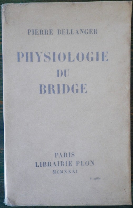
BELLANGER (Pierre).
Physiologie du bridge.
P., Plon, 1931, 1 vol. in-8 br. de VIII - 491 pp.
Referentie van de boekhandelaar : 3734
|
|
|
BELLANGER Pierre
Physiologie du bridge
Plon 1931, In-8 broché, viii + 492 pages. Exemplaire non coupé. Petites salissures à la couverture sans gravité. Bon état.
|
|
|
BELLANGER, Pierre
PHYSIOLOGIE DU BRIDGE
Paris Librairie Plon 1931 in 8 (22,5x14) 1 volume reliure demi basane marron à coins, couverture conservée, VIII et 491 pages (reliure signée: P. Ruffel, relieur). Bon exemplaire
Referentie van de boekhandelaar : 15532
|
|
|
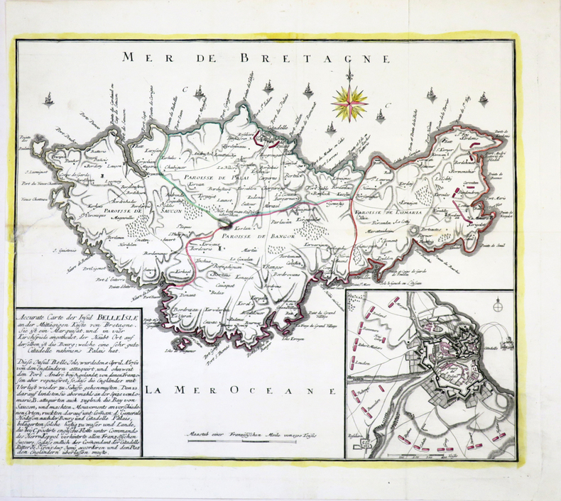
BELLE-ÎLE-en-MER.
Accurate Carte der Insul Belle Isle an der mittägigen Küste von Bretagne.
[circa 1761]. 365 x 435 mm.
Referentie van de boekhandelaar : LBW-4005
|
|
|
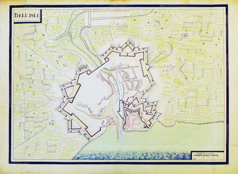
BELLE-ÎLE-en-MER. MANUSCRIT.
Bell'Isle.
[circa 1700]. 480 x 660 mm.
Referentie van de boekhandelaar : LBW-4187
|
|
|
BELLEFOREST (François de).
[ANGOULÊME] Le vray plan ou pourtraict de la ville d'Engoulesme.
[Paris, Nicolas Chesneau, 1575]. 295 x 354 mm.
Referentie van de boekhandelaar : LBW-8961

|
|
|
BELLEFOREST (François de).
[EMBRUN] Pourtraict de la ville d'Ambrun - La ville d'Ambrun en Dauphiné.
[Paris, Nicolas Chesneau, 1575]. 290 x 354 mm.
Referentie van de boekhandelaar : LBW-8971

|
|
|
BELLEFOREST (François de).
[LOCHES] La ville et chasteau de Loches.
[Paris, Nicolas Chesneau, 1575]. 203 x 375 mm.
Referentie van de boekhandelaar : LBW-8992

|
|
|
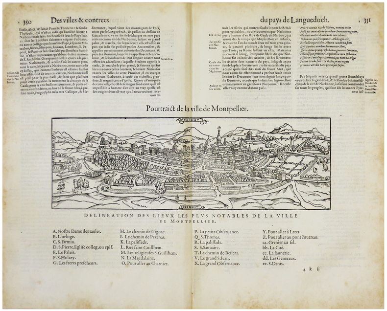
BELLEFOREST (François de).
[MONTPELLIER] Pourtraict de la ville de Montpellier.
[Paris, Nicolas Chesneau, 1575]. 176 x 310 mm (vue et légendes).
Referentie van de boekhandelaar : LBW-5507
|
|
|
BELLEFOREST (François de).
[NEVERS] Le vray portraict de la ville, & chasteau de Nevers.
[Paris, Nicolas Chesneau, 1575]. 273 x 338 mm.
Referentie van de boekhandelaar : LBW-8995

|
|
|
BELLEFOREST (François de).
[NÎMES] Le vray pourtraict de la ville de Nismes.
[Paris, Nicolas Chesneau, 1575]. 260 x 397 mm.
Referentie van de boekhandelaar : LBW-9007

|
|
|
BELLEFOREST (François de).
[ROMANS-sur-ISÈRE] Le vray portraict de la ville et cité de Romans - La ville de Romans en Dauphiné.
[Paris, Nicolas Chesneau, 1575]. 280 x 354 mm.
Referentie van de boekhandelaar : LBW-8984

|
|
|
BELLEFOREST (François de).
[VALENCE] Le vray portraict de la ville et cité de Valence - La cité de Valence en Dauphiné.
[Paris, Nicolas Chesneau, 1575]. 290 x 367 mm.
Referentie van de boekhandelaar : LBW-8980

|
|
|
BELLEFOREST (François de).
La ville, cité, université, & faux-bourgs de Paris.
[Paris, Nicolas Chesneau, 1575]. 422 x 551 mm.
Referentie van de boekhandelaar : LBW-8239

|
|
|
BELLEFOREST (François de).
Le Pourtraict de la Ville de Rouen.
Paris, Nicolas Chesneau, 1575. Gravure sur bois de 40 cm x 33 cm, légende avec lettres et numéros dans la marge inférieure désignant les rues et monuments, texte en français au verso. Très bon état. Sous verre dans un cadre moderne en chêne foncé, 53 x 47 cm.
Referentie van de boekhandelaar : 20642

|
|
|
Belleyme
CARTES DE PIERRE BELLEYME.
Cartes originales de Belleyme toilées.35 de 90cm/56. 16 1/2 de 45cm/59.Numéros: 3.8.9.10.14.15.22.24.28.29.30.31.Bon état.
Referentie van de boekhandelaar : 50736
|
|
|
BELLEYME (Pierre de).
[AQUITAINE] Carte de la Généralité d'Aquitaine dédiée à Monsieur de Néville, intendant de la province.
1787. En trois feuilles coupées en 40 sections montées sur toile et repliées, formant une carte de 1,31 x 1,50 m.
Referentie van de boekhandelaar : LBW-8939

|
|
|
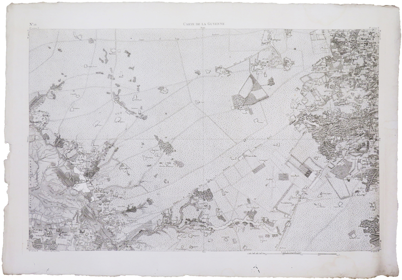
BELLEYME (Pierre de).
[BASSIN d'ARCACHON] Carte de la Guyenne [dite Carte de Belleyme]. Feuille n°26 (Le Teich).
[1785]. 585 x 895 mm.
Referentie van de boekhandelaar : LBW-7565
|
|
|
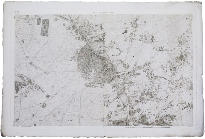
BELLEYME (Pierre de).
[DORDOGNE] Carte de la Guyenne [dite Carte de Belleyme]. Feuille n°29.
[1785]. 590 x 903 mm.
Referentie van de boekhandelaar : LBW-7539

|
|
|
BELLEYME (Pierre de).
[GIRONDE] Carte de la Guyenne [dite Carte de Belleyme]. Feuille n°21.
[1785]. 585 x 900 mm.
Referentie van de boekhandelaar : LBW-7544

|
|
|
BELLEYME (Pierre de).
[GIRONDE] Carte de la Guyenne [dite Carte de Belleyme]. Feuille n°13.
[1785]. 580 x 894 mm.
Referentie van de boekhandelaar : LBW-7556

|
|
|
BELLEYME (Pierre de).
[GIRONDE] Carte de la Guyenne [dite Carte de Belleyme]. Feuille n°34.
[1785]. 580 x 892 mm.
Referentie van de boekhandelaar : LBW-7603

|
|
|
BELLEYME (Pierre de).
[GIRONDE] Carte de la Guyenne [dite Carte de Belleyme]. Feuille n°35.
[1785]. 590 x 902 mm.
Referentie van de boekhandelaar : LBW-7604

|
|
|
BELLEYME (Pierre de).
[LANDES] Carte de la Guyenne [dite Carte de Belleyme]. Feuille n°33.
[1785]. 585 x 895 mm.
Referentie van de boekhandelaar : LBW-7567
|
|
 De zoekresultaten per email ontvangen
 Zoekresultaten downloaden als PDF
 RSS feed


