|
Cram, Geo. F.
1889 Color Map of the State of Kansas
Outer dimensions: 10.75" x 14.5". Counties individually colored. Clean and unmarked with light wear. A quality vintage copy. Bonus: includes separate extensive list of Kansas counties and cities/towns, complete with (1889) population of each. Book

|
|
|
Cram, Geo. F.
1889 Color Map of the State of Louisiana
Outer dimensions: 10.75" x 14.5". Counties individually colored. Clean and unmarked with light wear. An attractive vintage copy. Bonus: includes separate list of Louisiana counties and cities/towns, complete with their (1889) populations. Book

|
|
|
Cram, Geo. F.
1889 Color Map of the State of Minnesota
Outer dimensions: 10.75" x 14.5". Counties individually colored. Clean and unmarked with light wear. An attractive vintage copy. Book

|
|
|
Cram, Geo. F.
1889 Color Map of the State of Missouri
Outer dimensions: 10.75" x 14.5". Counties individually colored. Clean and unmarked with light wear. A quality vintage copy. Bonus: includes separate extensive list of Missouri counties and cities/towns, complete with (1889) population of each. Book

|
|
|
Cram, Geo. F.
1889 Color Map of the State of Montana
Outer dimensions: 21.75" x 14.5". Counties individually colored. Clean and unmarked with light wear. A handsome vintage copy. Book

|
|
|
Cram, Geo. F.
1889 Color Map of the State of New Mexico
Outer dimensions: 10.75" x 14.5". Counties individually colored. Clean and unmarked with light wear. An attractive vintage copy. Book

|
|
|
Cram, Geo. F.
1889 Color Map of the State of Pennsylvania
Vintage state map with counties individually colored. Outer dimensions: 21.75" x 14.5". Unmarked with light wear. Center fold. A quality example. Bonus: includes separate extensive list of counties and towns/cities of Pennsylvania, indicating (1889) population of each. Book

|
|
|
Cram, Geo. F.
1889 Color Map of the State of Wyoming
Outer dimensions: 10.75" x 14.5". Counties individually colored. Clean and unmarked with light wear. One-inch opening to lower left edge. An attractive vintage copy. Bonus: includes separate list of Wyoming counties and cities/towns, complete with their (1889) populations. Book

|
|
|
Cram, Geo. F.
1889 Color Map of the States of Virginia and West Virginia
Vintage state map with counties individually colored. Outer dimensions: 21.75" x 14.5". Unmarked with light wear. Center fold. A quality example. Bonus: includes separate extensive list of counties and towns/cities for each state, indicating (1889) population of each. Book

|
|
|
Cram, Geo. F.
1889 Color Map of the World
Outer dimensions: 10.75" x 14.5". Unmarked with light wear. Color corner illustrations indicate the globe's greatest mass of land, greatest mass of water, north pole regions, and south pole regions. A quality vintage copy. Book

|
|
|
Cram, Geo. F.
1889 Color Map of Wisconsin and Michigan
Vintage state map with counties individually colored. Outer dimensions: 21.75" x 14.5". Unmarked with light wear. Center fold. A quality example. Bonus: includes separate extensive list of counties and towns/cities of Michigan, indicating (1889) population of each. Book

|
|
|
Cram, Geo. F.
1889 Color Pie Charts of World Population By Country, Continent, Religion and Race
Outer dimensions: 10.75" x 14.5". A fascinating and informative presentation of the population of the world in 1889. Main pie chart breaks illustrates the world's population by country and continent. Smaller pie charts present world population by religion and race. Clean and unmarked with light wear. A quality vintage copy. Book

|
|
|
Cram, Geo. F.
1889 Colored Map of the Oklahoma Country in the Indian Territory
Outer dimensions: 10.75" x 14.5". Clean and unmarked with light wear. An attractive vintage copy. Book

|
|
|
Cram, Geo. F.
1889 Colour Map of the Dominion of Canada
Outer dimensions: 10.75" x 14.5". Unmarked with light wear. A quality vintage copy. Book

|
|
|
Cram, Geo. F.
1889 Colour Map of the Province of Ontario, Canada
Counties individually colored. Outer dimensions: 10.75" x 14.5". Unmarked with light wear. A quality vintage copy. Book

|
|
|
Cram, Geo. F.
1899 Color Map of New York State
Counties individually colored. Outer dimensions: 21.75" x 14.5". Unmarked with moderate wear. Center fold. 2" opening to bottom edge near fold mended with archival tape. A quality vintage copy. Bonus: includes separate extensive list of New York's counties and towns/cities and their (1889) populations. Book

|
|
|
Cramm, Geo. F.
1889 Color Map of Asia, Including Expanded Views of Jerusalem, Canton and Delhi
Outside dimensions 14.5" x 21.75". Unmarked with light wear and soiling. An attractive vintage copy. Book

|
|
|
Cramm, Geo. F.
1889 Color Map of Australia and Tasmania
Outside dimensions 10.75" x 14.5". Unmarked with light wear and soiling. An attractive vintage copy. Book

|
|
|
Cramm, Geo. F.
1889 Color Map of Austria
Outside dimensions 10.75" x 14.5". Unmarked with light wear and soiling. An attractive vintage copy. Book

|
|
|
Cramm, Geo. F.
1889 Color Map of Central America
Outside dimensions 10.75" x 14.5". Unmarked with light wear and soiling. An attractive vintage copy. Book

|
|
|
Cramm, Geo. F.
1889 Color Map of China, With Inset Map of Japan
Outside dimensions 10.75" x 14.5". Unmarked with light wear and soiling. An attractive vintage copy. Book

|
|
|
Cramm, Geo. F.
1889 Color Map of Egypt, Arabia, Upper Nubia and Abyssinia
Outside dimensions 14.5" x 10.75". Unmarked with light wear and soiling. An attractive vintage copy. Book

|
|
|
Cramm, Geo. F.
1889 Color Map of Europe
Outside dimensions 10.75" x 14.5". Unmarked with light wear and soiling. An attractive vintage copy. Book

|
|
|
Cramm, Geo. F.
1889 Color Map of France
Outside dimensions 10.75" x 14.5". Local districts individually colored. Unmarked with light wear and soiling. An attractive vintage copy. Book

|
|
|
Cramm, Geo. F.
1889 Color Map of India
Outside dimensions 14.5" x 10.75". Unmarked with light wear and soiling. An attractive vintage copy. Book

|
|
|
Cramm, Geo. F.
1889 Color Map of Ireland
Outside dimensions 14.5" x 10.75". Counties individually coloured. Unmarked with light wear and soiling. An attractive vintage copy. Book

|
|
|
Cramm, Geo. F.
1889 Color Map of Italy
Outside dimensions 14.5" x 10.75". Regions individually colored. Unmarked with light wear and soiling. An attractive vintage copy. Book

|
|
|
Cramm, Geo. F.
1889 Color Map of Japan (Nihon)
Outside dimensions 14.5" x 10.75". Unmarked with light wear and soiling. An attractive vintage copy. Book

|
|
|
Cramm, Geo. F.
1889 Color Map of Palestine
Outside dimensions 14.5" x 10.75". Unmarked with light wear and soiling. 4" archival tape mend to lower right corner. An attractive vintage copy. Book

|
|
|
Cramm, Geo. F.
1889 Color Map of San Francisco, California (CA)
Outside dimensions 14.5" x 10.75". Includes many street names, prominent buildings, hotels, churches, theatres, steam roads, cable and horse roads. Unmarked with light wear and soiling. An attractive vintage copy. Book

|
|
|
Cramm, Geo. F.
1889 Color Map of Sweden and Norway
Outside dimensions 14.5" x 10.75". Unmarked with light wear and soiling. An attractive vintage copy. Book

|
|
|
Cramm, Geo. F.
1889 Color Map of the City of Minneapolis, Minnesota (MN)
Outside dimensions 14.5" x 10.75". Includes many street names. Steam and horse railroads indicated. Unmarked with light wear and soiling. An attractive vintage copy. Book

|
|
|
Cramm, Geo. F.
1889 Color Map of the City of New Orleans, Louisiana (LA)
Outside dimensions 14.5" x 10.75". Steam and horse roads indicated. Includes many street names plus lists of prominent buildings and hotels. Unmarked with light wear and soiling. An attractive vintage copy. Book

|
|
|
Cramm, Geo. F.
1889 Color Map of the City of Omaha, Nebraska (NE)
Outside dimensions 14.5" x 10.75". Includes many street names. Unmarked with light wear and soiling. An attractive vintage copy. Book

|
|
|
Cramm, Geo. F.
1889 Color Map of the City of St. Louis, Missouri (MO)
Outside dimensions 14.5" x 10.75". Steam and horse roads indicated. Includes many street names plus lists of prominent buildings, hotels, depots and theatres. Unmarked with light wear and soiling. An attractive vintage copy. Book

|
|
|
Cramm, Geo. F.
1889 Color Map of the East Indies
Outside dimensions 10.75" x 14.5". Unmarked with light wear and soiling. An attractive vintage copy. Book

|
|
|
Cramm, Geo. F.
1889 Color Map of The Turkish Empire in Europe and Asia, Greece, Roumania, Etc.
Outside dimensions 10.75" x 14.5". Unmarked with light wear and soiling. An attractive vintage copy. Book

|
|
|
Cramm, Geo. F.
1889 Color Map Showing the Territorial Growth of the United States 1776-1887
Outside dimensions 10.75" x 14.5". Unmarked with light wear and soiling. An attractive vintage copy. Book

|
|
|
CRANGA
Le canton de Tramayes en 1900... à travers les cartes postales.
Editions de Saint-Seine-l'Abbaye, 1984, 105 p., broché, bon état.
Référence libraire : 87058
|
|
|
Cranny, Michael W.; Garrod, Stan; McGuire, Margit; Birchell, Gary
Pacific Rim Discovery - Student Resource
96 pages. Gazetteer. Maps and abundant colour illustrations and photos throughout. Bit of liquid paper atop front free endpaper otherwise clean and unmarked with moderate wear. Binding tight. A quality copy. Book

|
|
|
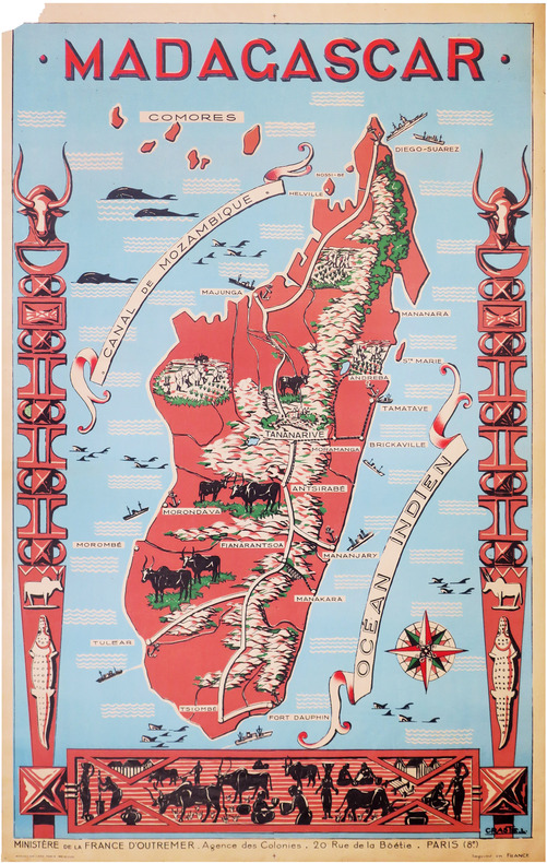
CRASTE (Léo).
[MADAGASCAR] Madagascar.
Paris, Affiches Gaillard, [vers 1950]. 1,16 x 0,74 m ; sur papier fin.
Référence libraire : LBW-8591
|
|
|
Creighton, John
Cheshire: A Portrait in Words and Pictures
Neat inscription to front end paper. No other marks or inscriptions. Very minor creasing to lower corner of front cover, none to rear or to spine. A very clean very tight copy with bright unmarked boards, a trace of sunning to lower front edge and no bumping to corners. 156pp. A guide to Cheshire, its history, its places to visit and its industry and industrial heritage. Well illustrated.

|
|
|
Crepax Guido:
Histoire d'O - Série de 8 cartes postales.
Amsterdam, Blue Circle Books, 1992. Série complète en 8 cartes postales, à l'état de neuf. Si vous avez l'impression que l'on en a caché des morceaux sur la photo, sachez que vous avez raison (restons pudiques, un minimum. . .)
Référence libraire : 26405

|
|
|
CREPY (Etienne-Louis).
Carte nouvelle des environs de Paris contenant aussy la Brie.
Paris, Crépy, 1753. En 16 sections montées sur toile et pliées, formant une carte de 503 x 718 mm.
Référence libraire : LBW-747
|
|
|
CREVIER
Histoire des empereurs romains
depuis Auguste jusqu’à Constantin.6 volumes en 6 tomes sur 12.Tomes 1,3,4,6,8,12,in 12 plein veau glacé fauve,pièce de titre chagrin rouge et pièce de tomaison chagrin vert, fars,roulette,palmette dorés.roulette dorée sur coupes. Tome :faux-titre,titre,XVIII,2 cartes dépliantes La Palestine par le Sieur d’Anville 1750.Germanie et les pays situés entre le Danube et la mer Adriatique par le sieur d’Anville 1749.529 pages,22 pages de table.Tome 3:titre, carte dépliante La Grande Bretagne par le sieur d’Anville Mars 1750 480 pages,14 pages de table.Tome 4:titre,518 pages,18 pages de table et approbation. Tome 6:titre,II,539 pages,20 pages de table et fautes à corriger. Mouillure, longitudinale en fin de volume, et en tête en début de volume. Tome VIII titre,I,494 pages,18 pages de table et fautes à corriger. Tome XII titre,600 pages pâle mouillure en tête. Desaint & Saillant 1749-1755.
Référence libraire : 6560

|
|
|
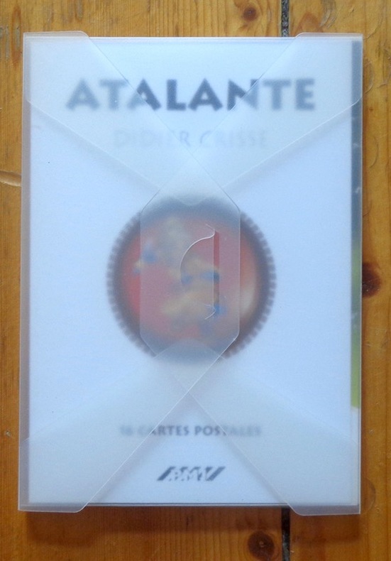
CRISSE Didier
Atalante - 16 cartes postales
16 cartes postales sous pochette translucide (Ref.: ref95693)
Référence libraire : 9782845222488
|
|
|
Crisse Didier:
Atalante. 16 cartes postales.
PMJ éditions Port-folio translucide, bien complet des 16 cartes postales annoncées au feuillet de titre. A l'état de neuf.
Référence libraire : 911
|
|
|
Crofton, Ian
Walking the Border : A Journey Between Scotland and England
Book and jacket appear in as new unread condition. 246pp. A complete walk along the Border from Gretna to Lamberton, just north of Berwick on Tweed, filled with information on nature, literature, history and the people who lived there.

|
|
|
Crookston, Peter (editor)
Village England
No inscriptions or marks. A lovely clean crisp very tight copy with bright unmarked boards and no bumping to corners. Dust jacket not price clipped or torn or creased. 256pp. Taken from the highly successful Observer Magazine series, Village England is a catalogue of all that is best in England. Twenty-four towns were chosen as centres to explore, and their surrounding villages are detailed with places to visit, things to do, national parks, model railways, places to eat and drink etc. With over 170 colour photographs, it is an introduction to the true England: quiet, picturesque, calm and beautiful.

|
|
|
Crosher, G.R.
Along the Chiltern Ways
Ex-library copy with usual (minimal) marks and stamps. A very clean very tight copy with bright unmarked boards, upper corner of front end paper clipped and no bumping to corners. Dust jacket not price clipped or marked or torn with minor traces of handling. 178pp. A study of the areas around the Icknield Ways, the two ancient green lanes that run from Goring on the Thames to beyond Royston at the edge of East Anglia.

|
|
 Recevoir par e-mail
 Télécharger en PDF
 Flux RSS


