|
Cycle Maps UK
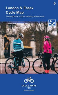
London and Essex Cycle Map 7
Sheet map folded. New. unknown
Referentie van de boekhandelaar : A9781904207757 ISBN : 1904207758 9781904207757
|
|
|
Cycle Maps UK
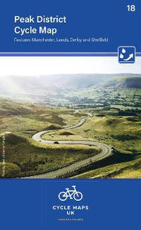
Peak District Cycle Map 18 Cycle Maps UK
new. unknown
Referentie van de boekhandelaar : 44619596-n ISBN : 1904207731 9781904207733
|
|
|
Cycle Maps UK
Peak District Cycle Map 18 Cycle Maps UK
like new. unknown
Referentie van de boekhandelaar : 44619596 ISBN : 1904207731 9781904207733
|
|
|
Cycle Maps UK
Peak District Cycle Map 18
Sheet map folded. New. New Book; Fast Shipping from UK; Not signed; Not First Edition; The maps are all produced at a scale of 1:100 000 showing important features including the National cycle Network. Sections on road off road and traffic free are all shown in differing colours along with their route number. unknown
Referentie van de boekhandelaar : ria9781904207733_inp ISBN : 1904207731 9781904207733

|
|
|
Cycle Maps UK
Peak District Cycle Map 18 Cycle Maps UK
Cycle Maps UK 2022. Map. New. 2 pages. 6.42x3.94x0.63 inches. Cycle Maps UK unknown
Referentie van de boekhandelaar : 2-1904207731 ISBN : 1904207731 9781904207733
|
|
|
Cycle Maps UK
Peak District & Lincolnshire Cycle Map 14
Sheet map folded. New. unknown
Referentie van de boekhandelaar : A9781904207733 ISBN : 1904207731 9781904207733
|
|
|
Cycle Maps UK
Peak District Cycle Map 18 Cycle Maps UK
Cycle Maps UK 2022. Map. New. 2 pages. 6.42x3.94x0.63 inches. Cycle Maps UK unknown
Referentie van de boekhandelaar : __1904207731 ISBN : 1904207731 9781904207733
|
|
|
CYCLING & MOTORING MAP OF EXETER DISTRICT
Bacon's Cycling and Motoring Map of Exeter District[Cycling and Touring] Map of 60 Miles South of London, including Worthing, Brighton, Hastings, etc.. Scale Half an Inch to One Mile. NEAR FINE COPY
8vo., folding map on cloth, coloured in outline, measuring 15 x 20 inches (approx. 38 x 51 cms) folding in 18 panels to 5.25 x 3.5 inches (approx. 13 x 9 cms); red limp cloth wrappers lettered in black, radial corners, a near fine copy. With trade advertisements. SCARCE IN THIS CONDITION.
|
|
|
Cyprus Tourism Organisation
A Visitor's Map of Cyprus
Large fold-out map. Scale 1: 350000.[40 x 63 cm; folded to 11 x 23 CM.] Map
|
|
|
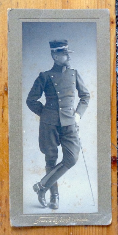
Cérenville B. de :
Portrait photographique en pied.
Lausanne, Francis de Jongh, [1914]. Photographie au format 8 x 17 cm., nom du photographe doré au bord inférieur. Légèrement frottée, avec quelques rousseurs.
Referentie van de boekhandelaar : 8157
|
|
|
Cüstrin:
Cüstrin. "Plan der Belagerung der Stadt und Vestung Cüstrin durch die Kaiserl. Russische Armee im Monath August An.1758." Stadtplan von Cüstrin. Kupferstich mit farbigen Truppenaufstellungen. Aus "Neues Kriegs-Theater", Supplement No. 4.
Format: 18 x 29,5 cm. *Leicht gebräunt, insgesamt gut erhalten. Landkarten de
|
|
|
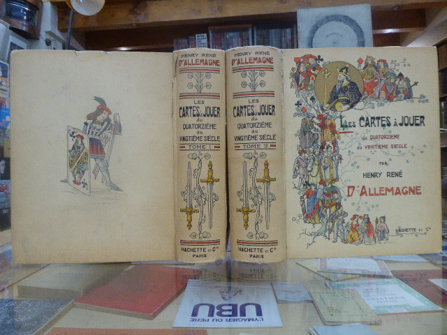
D'Allemagne Henri René
Les Cartes A Jouer du Quatorzième Au Vingtième Siècle
Hachette Et Cie Editeur - Paris - 1906 - Edition Originale - Deux gros volumes épais- Complet - Volume 1 :504 pages, volume 2 :640 pages .Exceptionnel ouvrage contenant 3200 reproductions de cartes à jouer ,956 en couleurs,12 planches hors texte acquaréllées main ,25 phototypies,116 enveloppes de cartes à jouer ,340 vignettes et vues diverses, tables des matières complètes en fin de chaque volume - Serpentes protégeant bien les gravures - Volumes in folio non rogné demi veau rouge ,dos à nerfs ,couvertures conservées ,intérieur très frais,pas de rousseur .
Referentie van de boekhandelaar : 9812

|
|
|
D'ANVILLE
L'Europe.
Géographie Ancienne, Abrégée. Avec les Cartes Géographiques nécessaires pour faciliter l'intélligence. Tome 1er seul: Contenant L'Europe. 1 frontispice par Gravelot et Simonet et 6 cartes repliées. Paris, Chez P. Théophile Barrois, Jeune, Libraire, 1782. In-12 (17x10cm) plein veau raciné d'époque, dos lisse orné de motifs et tomaison dorés, tranches rouges, petite fente sur la charnière supérieure, coins émoussés. XXIV,341pp.+ 1ff errata.
Referentie van de boekhandelaar : WOC-2454

|
|
|
D'Anville Jean Baptiste Bourguignon (1697-1782)
Plan de Rome Ancienne Dressé pour L'intilligence de l'histoire Romaine de Mr. Rollin
Pianta di Roma antica disegnata da Jean-Baptiste Bourguignon D'anville per la Storia romana del Rollin. Histoire romaine depuis la fondation de Rome jusqu'à la bataille d'Actium di Charles Rollin divenne una tra le opere più durature dedicate alla storia romana, impreziosita da alcune carte geografiche inserite nell'Atlas de géographie ancienne pour servir à l'intelligence des oeuvres de Rollin: gravé d'après les cartes originales de d'Anville. Incisione in rame, consuete pieghe di carta, in ottimo stato di conservazione. Pianta di Roma antica disegnata da Jean-Baptiste Bourguignon D'anville per la Storia romana del Rollin. Histoire romaine depuis la fondation de Rome jusqu'à la bataille d'Actium di Charles Rollin divenne una tra le opere più durature dedicate alla storia romana, impreziosita da alcune carte geografiche inserite nell'Atlas de géographie ancienne pour servir à l'intelligence des oeuvres de Rollin: gravé d'après les cartes originales de d'Anville. Incisione in rame, consuete pieghe di carta, in ottimo stato di conservazione.

|
|
|
D'Anville, [Jean-Baptiste Bourgignon].
Golfe Persique. Dressé en 1758 et publié en 76 par le Sr. d'Anville, Prém[ier] Géogr[aphe] du Roi. [Paris], 1776.
Engraved map. 282 x 440 mm (image). 311 x 465 mm (sheet). The famous nautical chart by the French geographer and cartographer d'Anville (1697-1782), encompassing the Arabian Gulf from Basra to the Straits of Hormuz. Although the southwestern part of the Gulf is poorly explored, various Gulf cities are identified, including "Julfar" (Ras al-Khaimah), "Mekehoan" (Umm Al Quwain), "Kalba", and "Ras-ol Lima". The city of "Al Katif" is clearly identified. The Qatar Peninsula is entirely absent, but the island of Bahrain is noted (though misaligned), and the coastline between Bahrain and Abu Dhabi is marked as an "entirely unknown coast". - With several contemporary manuscript additions in ink, including "Gatar" (south of Bahrain) and "Kouait" (Kuwait), as well as a few later notes in pencil in the Bahrain area. Old shelfmarks on the reverse. Slightly toned. David Rumsey Map Collection 2603.025. Al-Qasimi (2nd ed.), p. 236.
|
|
|
D'ANVILLE, Jean-Baptiste Bourguignon / Jamaica
JAMAICA: 'Isle de la Jamaique.' - Original engraved map from 'Jean-Baptiste Bourguignon d'ANVILLE: Atlas portatif, vol. II'.
[Paris, Bibliothèque des dames, 1786.]. 1 sheet, with a decorated titlefield; Ca. 20,9 x 23,7 cm (will be shipped flat, unfolded).
Referentie van de boekhandelaar : 1505010565xbvk
|
|
|
D'ANVILLE, Jean-Baptiste Bourguignon: [de Anville]
Asia Minor - Turkey / Türkei / Türkiye: TURQUIE D'ASIE, DRESSÉE SUR LES OBSERVATIONS ASTRONOMIQUES. - Original engraved map from 'Jean-Baptiste Bourguignon d'ANVILLE: Atlas portatif, vol. II'.
Paris, Bibliothèque des dames, 1786. 1 sheet, with a decorated titlefield. Ca. 21,2 x 23,9 cm (will be shipped flat, unfolded).
Referentie van de boekhandelaar : 18071018xbvk
|
|
|
D'ANVILLE, Jean-Baptiste Bourguignon: [de Anville]
L'AMÉRIQUE MÉRIDIONALE, divisée en ses principaux États' (Latin-America/Mittelamerika). - Original engraved map from 'Jean-Baptiste Bourguignon d'ANVILLE: Atlas portatif, vol. II'.
Paris, Bibliothèque des dames, 1786. 1 sheet, with a decorated titlefield; ca. 21 x 24 cm (will be shipped flat, unfolded).
Referentie van de boekhandelaar : 1409151357xbvk
|
|
|
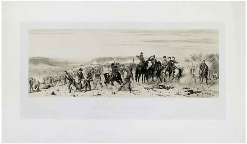
d'ORLEANS (François).
[GUERRE DE SÉCESSION/VIRGINIE] Bataille de Gaine's Mill. Virginie (27 juin 1862).
[1862]. 366 x 740 mm.
Referentie van de boekhandelaar : LBW-5489
|
|
|
D'Orta, Piemme and Enrika
Together in Pompeii
No marks or inscriptions. No creasing to covers or to spine. A lovely clean very tight copy with bright unmarked boards and no bumping to corners. Protected in fully-removable proprietary plastic sleeve. 64pp. Tucked in is a large fold-out plan of Pompeii. Travel guide with 110 coloured illustrations.

|
|
|
D'YEU Pierre. (Pierre Marie Alexis DIEULEFILS - Photographe et éditeur de cartes postales actif en France et à Hanoï à partir de 1888)
SUR LA CÔTE INDOCHINOISE. Aux ruines d'Angkor. En Cochinchine. En Annam. Au Tonkin.
Paris A.Paul, C.Vigier, Editions coloniales 1923 in-12 broché 1 volume, broché crème (paperback) in-octavo Editeur (22 x 14 cm), dos et couverture imprimés et illustrés en noir, 3 toute petites taches de café au niveau du titre sur la 1ère de couverture (mais vraiment trés légères), toutes tranches lisses, Rarissime recueil de poèmes illustrés de 26 planches-photographiques hors-texte à la sépia et de 14 photographies in-texte en noir. Imprimées sur beau papier, tirées des collections du photographe Dieulefils, 186 pages, 1923 Paris, A.Paul, C.Vigier, Editions coloniales et chez l'auteur, à Malestroit (Morbihan) Editeur,
Referentie van de boekhandelaar : 23423
|
|
|
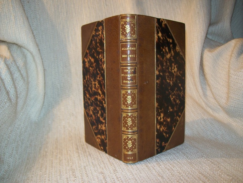
D*** L Amateur
ACADEMIE UNIVERSELLE DES JEUX. 3e édition.
Paris Corbet Aîné 1842. In-12 2 feuillets non chiffrés 2-401pp. Demi maroquin havane à larges coins signés, dos à nerfs, compartiments finement dorés, "Cercle du Commerce, Epernay" frappé au centre, tête dorée, relié vers 1880. Page 401 raccourcie sans perte de texte et contrecollée sur un feuillet blanc. Bel exemplaire sans aucune rousseur, dans une élégante reliure de la fin du XIXe siècle.
Referentie van de boekhandelaar : GITe691
|
|
|
D. B. A. Thompson; Colin Baxter
Scotland: Land of Mountains
No marks or inscriptions. A lovely clean very tight copy with bright unmarked boards and no bumping to corners. Dust jacket not price clipped or marked or torn or creased with minor sunning around spine. 128pp. Beautiful book on the wildness of Scotland's mountains with the superb photographs from Colin Baxter. We do not use stock photos, the picture displayed is of the actual book for sale. Every one of our books is in stock in the UK ready for immediate delivery.

|
|
|
Daddy, Bernard . [et al.] (eds.)
Wideworld: GCSE Geography Review
4 volume set, over 80 pages, illustrated, includes articles on the Kobe Earthquake, coastal pollution, ozone depletion and Pakistan. eng
|
|
|
Daen, Leonid ; Poznyak, Pavel & Cherp, Mark
Kiev Travel Guide
No marks or inscriptions to contents. No creasing to covers or to spine. A very clean very tight copy with bright vinyl boards, faint ink mark to rear and no bumping to corners. 224pp. Travel guide to Soviet Kiev with an emphasis on Soviet propaganda and history. Scarce in the UK.

|
|
|
DAGINCOURT (Emmanuel) & LAUNAY (Louis de) & BUSQUET (Horace).
[GÉOLOGIE/SAINT-PIERRE-le-MOÛTIER] Carte topographique de l'État-Major. Carte géologique détaillée. S.t Pierre. Feuille n°135.
Paris, Ch. Béranger, [1888]. En 27 sections montées sur toile et repliées, formant une carte de 0,62 x 1,16 m ; étiquette au dos de l'éditeur Charles Béranger.
Referentie van de boekhandelaar : LBW-9025

|
|
|
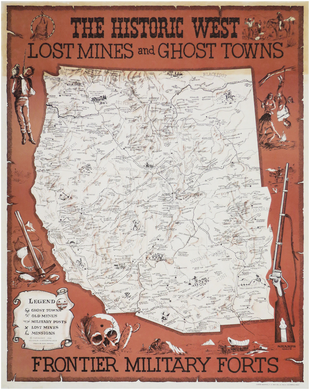
DAGOSTA (Andy).
The historic West. Lost mines and ghost towns, frontier military forts.
La Jolla, Cooper Enterprises, 1968. 705 x 547 mm.
Referentie van de boekhandelaar : LBW-8142
|
|
|
DAHI Soheyl (dir.):
Poets/Painters. 30 cards + 1.
San Fransisco, Sore Dove Press, 2008. 31 cartes en carton de 21,7 x 14 cm, dont une "carte de titre", imprimées en noir au verso, sous emboîtage de toile bleu nuit, titre argenté au premier plat, ruban noir pour extraire les cartes de l'emboîtage. Comme neuf.
Referentie van de boekhandelaar : 7673

|
|
|
DAHLBERG, ERIK.
Giöksholm. J.v.d. Aveelen Sc.
Holmiæ (Stockholm), 1702. 22,5x36,5 cm. Kobberstukket prospekt fra Svecia Antiqva et Hodierna. Et par smårifter i marginer, intet tab.
Referentie van de boekhandelaar : 28094
|
|
|
DAHLBERG, ERIK.
Giöksholm. J.v.d. Aveelen Sc.
Holmiæ (Stockholm), 1702. 22,5x36,5 cm. Kobberstukket prospekt fra Svecia Antiqva et Hodierna. Et par smårifter i marginer, intet tab.
|
|
|
DAHLBERG, ERIK.
Saalstad. W. Swidde Sculp.
Holmiæ (Stockholm), 1693. 21,5x41,5 cm. Kobberstukket prospekt med ridende og vognkørende folk i forgrunden. Fra Svecia Antiqva et Hodierna.
Referentie van de boekhandelaar : 28092
|
|
|
DAHLBERG, ERIK.
Saalstad. W. Swidde Sculp.
Holmiæ (Stockholm), 1693. 21,5x41,5 cm. Kobberstukket prospekt med ridende og vognkørende folk i forgrunden. Fra Svecia Antiqva et Hodierna.
|
|
|
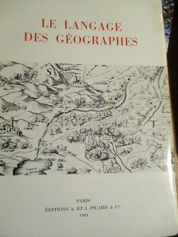
Dainville ( François de)
le langage des géographes
1964 Paris Picard et Cie 1964 In8 broché 384 pages 24 planches hors texte Index des termes très bon état
Referentie van de boekhandelaar : 5800
|
|
|
Dale, Alzina Stone and maps by Kenneth Daly
Mystery Reader's Walking Guide : New York
Lincolnwood Il. Passport Books 1994. 8vo. cloth backed boards hardcover; 361 pages; maps by Kenneth Dale; from the dustjacket: "11 walks that folow the paths of the most widely read mystery writers their sleuths and characters;" a fine clean tight unmarked copy in a fine dustjacket. <br/><br/> Lincolnwood, Il. Passport Books 1994) hardcover
Referentie van de boekhandelaar : 26192

|
|
|
DALLEMAGNE Henry-René
LES CARTES À JOUER du Quatorzième au Vingtième Siècle.
Librairie Hachette & Cie Paris 1906 2 volumes grands et forts in-4 ( 325 X 265 mm ) de XVI-504 et 640 pages, cartonnage éditeur illustré en couleurs, tête dorée. 3200 reproductions de cartes dont 956 en couleurs, 12 planches hors-texte coloriées à l'aquarelle, 25 phototypies, 116 enveloppes illustrées pour jeux de cartes & 340 vignettes & vues diverses. Edition originale et premier tirage. Minimes défauts aux mors et aux coiffes, ( comme toujours ), sinon très bel exemplaire, bien complet de ses serpentes, condition rare.
Referentie van de boekhandelaar : 684269
|
|
|
Dalley, Sam (editor)
The Independent Hostel Guide 1995; UK and Ireland
No marks or inscriptions and no creasing to covers. A very clean very tight copy with bright unmarked boards and no bumping to corners. 96pp. The first in a series of guides for outdoor enthusiasts and budget travellers.

|
|
|
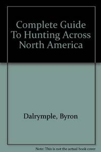
Dalrymple Byron; Maps by Delos D. Rowe Associates with basic maps courtesy ofRand McNally & Company
Complete Guide To Hunting Across North America
Harper & Row Publishers. hardcover. Good/Unclipped. 9x6x2. Presumed first ed. 1970; 848 p. clean and unmarked anywhere on strong paper mildly age-toned--but darker around edges of end pages suggesting inlaid material at some time; maps and photos; binding tight; despite presence of phtoographic d.j. the boards are much faded around edges and have slight rubbing at corners. D.j. itself is chipped at edges with open tears at crown of spine panel and at upper corner of rear panel. Harper & Row, Publishers hardcover
Referentie van de boekhandelaar : 092469 ISBN : 1199360163 9781199360168
|
|
|
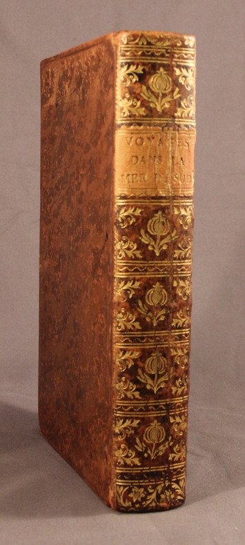
DALRYMPLE Alexander.; FREVILLE M. de (trad.):
Voyages dans la mer du Sud, par les Espagnols et les Hollandois.
A Paris, Chez Saillant & Nyon; Pissot, 1774. In-8 de [4]-XIV-[2]-502-[2] pages, plein veau brun moucheté, dos lisse orné de fleurons et motifs dorés, étiquette de titre orange, plats encadrés d’un filet à froid, tranches rouges.
Referentie van de boekhandelaar : 2118
|
|
|
Dalrymple, Byron; Maps by Delos D. Rowe Associates with basic maps courtesy ofRand McNally & Company
Complete Guide To Hunting Across North America
Harper & Row Publishers 1970-01-01. hardcover. New. In shrink wrap. Looks like an interesting title! Harper & Row, Publishers hardcover
Referentie van de boekhandelaar : Q-1199360163 ISBN : 1199360163 9781199360168
|
|
|
Dalrymple, Byron; Maps by Delos D. Rowe Associates with basic maps courtesy ofRand McNally & Company
Complete Guide To Hunting Across North America
Harper & Row Publishers 1970-01-01. Hardcover. Like New. 9x6x2. 1970 NO Dust cover! Book: New inside and Out! Clean & Crisp Pages. Email for more info/pics Harper & Row, Publishers hardcover
Referentie van de boekhandelaar : 220326041 ISBN : 1199360163 9781199360168
|
|
|
Dalrymple, Byron; Maps by Delos D. Rowe Associates with basic maps courtesy ofRand McNally & Company
COMPLETE GUIDE TO HUNTING ACROSS NORTH AMERICA An Outdoor Life Book.
New York & London: Harper & Row Publishers. VG/G. 1970. . Cloth. Specially prepared maps keyed to the text pinpoint Game Management Areas Waterfowl Refuges State and National Forests State Parks and other public hunting grounds. Includes a listing of private hunting preserves. . 8vo. 848pp. Jacket rubbed & frayed at tips with small tears . Harper & Row, Publishers hardcover
Referentie van de boekhandelaar : BOOKS238950
|
|
|
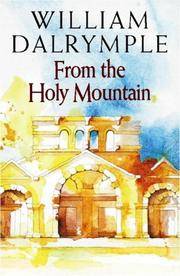
Dalrymple, William; Endpaper Maps, 12 Pages of Photos [Illustrator]
From the Holy Mountain: A Journey in the Shadow of Byzantium
HarperCollins 1997-01-01. Hardcover. New. In shrink wrap. Looks like an interesting title! HarperCollins hardcover
Referentie van de boekhandelaar : Q-0002555093 ISBN : 0002555093 9780002555098
|
|
|
Daly RN BA MEd(Hons) BHSc(N) PhD MACE AFACHSE FCN FRCNA, John/ Speedy RN BA(Hons) DipEd MURP EdN MAPS FANZCMHN, Sa
Leadership and Nursing: Contemporary perspectives 2e Year Books
Churchill Livingstone 2014. Paperback. New. 2nd edition. 296 pages. 9.65x6.89x0.71 inches. Churchill Livingstone paperback
Referentie van de boekhandelaar : x-0729541533 ISBN : 0729541533 9780729541534

|
|
|
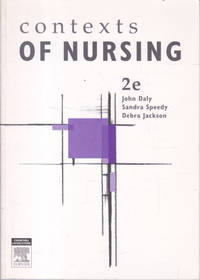
Daly RN BA MEd(Hons) BHSc(N) PhD MACE AFACHSE FCN FRCNA, John; Speedy RN BA(Hons) DipEd MURP EdD MAPS FANZCMHN, Sandra; Jackson
Contexts of Nursing: An Introduction Second Edition
Sydney: Churchill Livingstone Australia 2006 The cover is a little worn. 388 pages. Books listed here are not stored at the shop. Please contact us if you want to pick up a book from Newtown. Paper Back. Very Good. Churchill Livingstone Australia paperback
Referentie van de boekhandelaar : 161304 ISBN : 0729537463 9780729537469
|
|
|
Daly RN BA MEd(Hons) BHSc(N) PhD MACE AFACHSE FCN FRCNA, John; Speedy RN BA(Hons) DipEd MURP EdD MAPS FANZCMHN, Sandra; Jackson
Leadership and Nursing: Contemporary perspectives Year Books
like new. unknown
Referentie van de boekhandelaar : 21683857 ISBN : 0729541533 9780729541534
|
|
|
Daly RN BA MEd(Hons) BHSc(N) PhD MACE AFACHSE FCN FRCNA, John; Speedy RN BA(Hons) DipEd MURP EdD MAPS FANZCMHN, Sandra; Jackson
Leadership and Nursing: Contemporary perspectives Year Books
new. unknown
Referentie van de boekhandelaar : 21683857-n ISBN : 0729541533 9780729541534
|
|
|
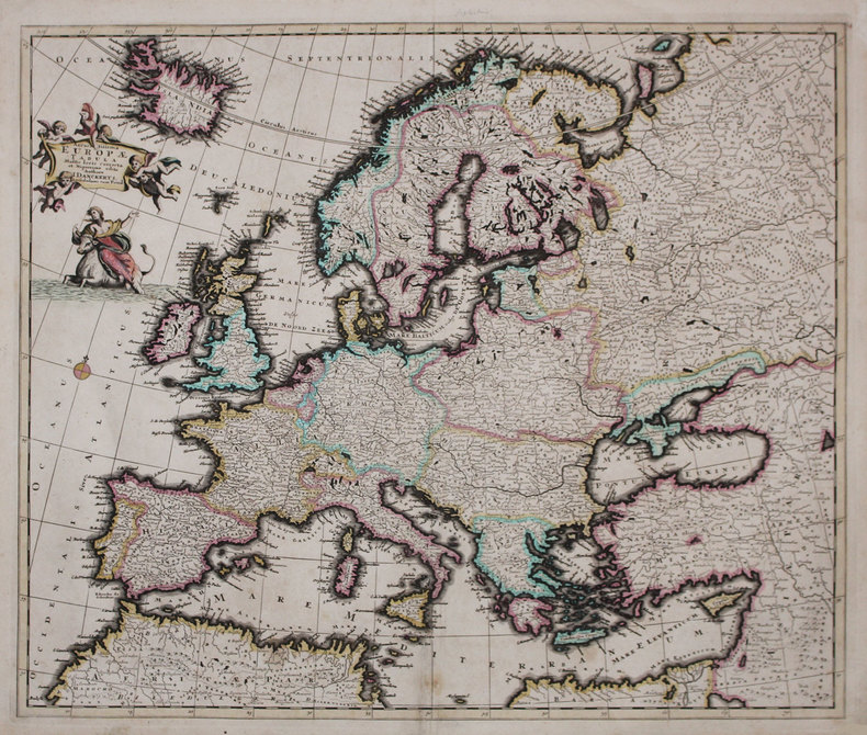
DANCKERTS (Justus).
Accuratissima Europæ tabula.
Amsterdam, [circa 1696]. 492 x 580 mm.
Referentie van de boekhandelaar : LBW-3222
|
|
|
Danckerts, Justus:
Novissima et accuratissima Helvetiae, Rhaetiae, Valesiae et Partis Sabaudiae Tabula. Ex officina Justi Danckerts
Format: 48,5 x 56,5 cm (bis zur äußeren Einfassungslinie beschnitten). *Generalkarte der Schweiz. Justus Danckerts (1635-1701) war Kupferstecher und Verleger in Amsterdam, Sohn des Kartenhändlers Cornelius Danckerts, er gründete um 1656 eine eigene Kartenoffizin. Gut erhalten. Landkarten de
|
|
|
DANGER Fernand
"Cours de législation et économie rurales; livre 1 : Le bornage."
Paris, Editions Eyrolles, 1948. "16 x 24, 307 pp., broché, bon état (couverture défraîchie; cachets d'ex-propriétaire dont 1 sur la couverture)."
Referentie van de boekhandelaar : 91159
|
|
|
Daniel Rops (Henri Petiot, dit ; 1901-1965) :
Histoire de l’Eglise du Christ. L’Eglise des Apôtres et des Martyrs. Orné de bois gravés par Jean Lébedeff.
Librairie Arthème Fayard (imprimerie Coulouma), 1948; 2 tomes in-8 (228 mm), brochés, couverture crème rempliée et illustrée ; 491, [3 bl.]; 505, [5 bl.] pp.
Referentie van de boekhandelaar : 21613

|
|
 De zoekresultaten per email ontvangen
 Zoekresultaten downloaden als PDF
 RSS feed


