|
Fuzzy Cognitive Maps For Applied Sciences And Engineering: From Fundamentals To Extensions And Learning Algorithms
1
Springer: Academic & Professional Europe. Hardbound/Brand New. 9783642397387. Papageorgiou. Academic & Professional hardcover
Bookseller reference : STM-9783642397387
|
|
|
FYN - (PONTOPPIDAN, ERIC).
Generalem hanc Fioniæ Tabulam Geographicam...ut et Provinciæ Fionensis ac Prefecturar: Othon: Dalum: etc: supremo Præfecto. officiosissime inscribit A.H. Godiche.
(København), A.H. Godiche, 1766. 46,5 x 55,5 cm. Kobberstukket kort over Fyn og omgivende vande med Tåsinge og en del af Langeland. Stor fin rokokkokartouche. Nederste del af venstre margin lidt tæt beskåret, dog uden tab af billede. Ren og frisk, på svært skrivepapir.
|
|
|
FYN - (PONTOPPIDAN, ERIC).
Generalem hanc Fioniæ Tabulam Geographicam...ut et Provinciæ Fionensis ac Prefecturar: Othon: Dalum: etc: supremo Præfecto. officiosissime inscribit A.H. Godiche.
(København), A.H. Godiche, 1766. 46,5 x 55,5 cm. Kobberstukket kort over Fyn og omgivende vande med Tåsinge og en del af Langeland. Stor fin rokokkokartouche. Nederste del af venstre margin lidt tæt beskåret, dog uden tab af billede. Ren og frisk, på svært skrivepapir.
Bookseller reference : 43462
|
|
|
FÉCHET, Serge (Texte) - Fechet, Roger (Cartes postales anciennes)
Sur la route du Verre dans la Loire au fil du temps
2005 Editions du Mot Passant, Villeurbanne - 2005 - In-8 carré, broché, couverture illustrée - 119 pages
Bookseller reference : 123854
|
|
|
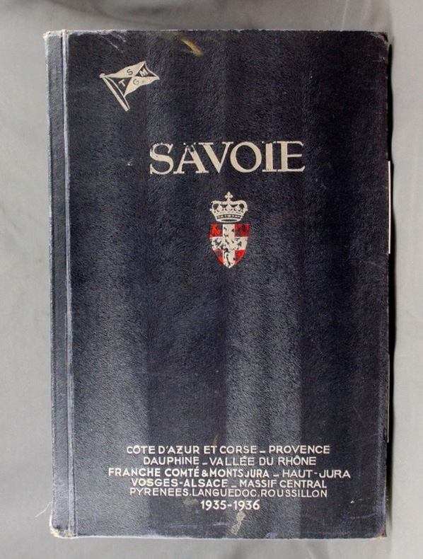
Fédération des Syndicats d’Initiative (publ.):
Savoie, Côte d’azur et Corse, Provence, Dauphiné, Vallée du Rhône, Franche Comté & Mont Jura, Haut-Jura, Vosges-Alsace, Massif Central, Pyrénées, Languedoc, Roussillon. 1935-1936.
Marseille, Ed. des Albums touristiques de Luxe, 1935. In-folio de 62, 42, 46, 78, 54, 32, 42 pages, pleine percaline bleue, 1er plat orné de l’écusson de Savoie.
Bookseller reference : 2024
|
|
|
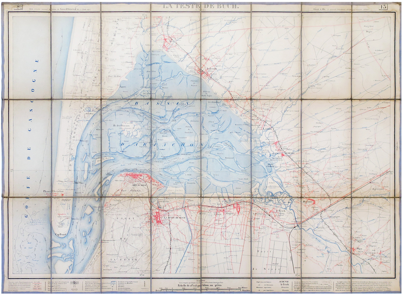
FÉRET & FILS.
[BASSIN d'ARCACHON] La Teste de Buch.
Bordeaux, Féret & Fils, 1875. En 24 sections montées sur toile et pliées, formant une carte de 632 x 863 mm.
Bookseller reference : LBW-6806
|
|
|
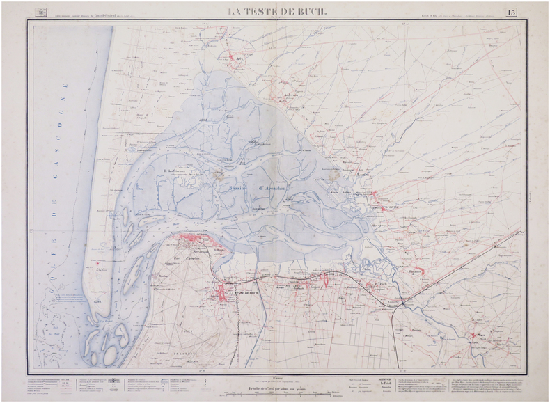
FÉRET & FILS.
[BASSIN d'ARCACHON] La Teste de Buch.
Bordeaux, Féret & Fils, 1875 [1888]. 625 x 830 mm.
Bookseller reference : LBW-7911
|
|
|
FÉRET & FILS.
Carte vinicole de la Gironde. Les grands vins des successeurs de M. Bassagaix Fils, négociants à Bordeaux (Gironde).
Bordeaux, Féret & Fils, [circa 1915]. 590 x 370 mm.
Bookseller reference : LBW-6669

|
|
|
Förster Ernst Joachim (8 April 1800 – 29 April 1885)
Roma. Rioni, Regionen oder Abtheilungen Rom's
Pianta della città di Roma con la carta topografica di Roma e dei suoi contorni. Leggenda molto dettagliata ed estesa che elenca circa 200 edifici, monumenti e luoghi di interesse a Roma. Litografia, dimensioni complessive 54,5 x 65 cm, dimensioni dell'immagine 52 x 63 cm, pieghe multiple orizzontali e verticali come piegate in un libro, nel complesso in ottime condizioni. Opera tratta da Handbuch für Reisende in Italien von Dr. Ernst Förster, stampata a München dal Literarisch-Artistische Anstalt nel 1857. Large city plan of Rome titled: Roma. Rioni, Regionen oder Abtheilungen Rom's, with inset map Carta topografica di Roma e dei suoi contorni. Very detailed, extensive legend listing approx. 200 buildings, monuments and places of interest in Rome. Overall size 54.5 x 65 cm, image size 52 x 63 cm, multiple horizontal and vertical folds as folded in a book, overall in very good condition. From: Handbuch für Reisende in Italien von Dr. Ernst Förster, München, Literarisch-Artistische Anstalt, 1857.

|
|
|
G. BEUDIN
REGLES DE TOUS LES JEUX
Un ouvrage de 293 pages, format 120 x 190 mm, broché couverture couleurs, publié en 1962, Editions Albin Michel, bon état
Bookseller reference : LFA-126739299
|
|
|
G.B. DEPPING
Les jeunes voyageurs en France ou Lettres sur les départemens
à Paris chez Etienne Ledoux, libraire. quatrième édition - 1834 6 volumes de format 10 x 15 cm, reliure demi-basane d'époque, plats et gardes marbrés entre 258 et 314 pages par volume, illustrés de 17 gravures, 86 cartes de départements et une carte de la France dépliante. COMPLET un mors du tome 2 fendu (voir photo) sinon Bon état
Bookseller reference : 350

|
|
|
G.H.J.
[BESANÇON] Plan de la ville et citadelle de Besançon, capitale de la Franche Comté, avec tous les changements faits jusqu'à présent. Par M.r G.H.J. Ingénieur Géographe.
1788. 511 x 774 mm.
Bookseller reference : LBW-8302

|
|
|
G.W. Bacon & Co. Ltd.
[WWI] War Map Issued By The Family Herald & Weekly Star
This copy bearing the ink stamp of F.R. Swanton of Davis Point, Manitoba. Frederick Swanton served in the 200th (Winnipeg) Battalion, Canadian Expeditionary Force (CEF) during WWI. Illustrated red card covers measure 8.25" x 5.5". Map folds out to 40" by 31". Undated but appears to be circa 1918. Issued as a supplement to Montreal publications The Family Herald and Weekly Star by permission G.W. Bacon & Co. Ltd., 127 Strand, London. Detailed black and white map of Europe presents the setting of World War I, presumably as a reference for Canadians following the progress of the war. Average wear. Several unobtrusive clear tape repairs. A sound vintage copy of this Canadian WWI memento with special noted provenance. Book

|
|
|
GA. Henty; with Ten Page Illustrations by Alfred Pears and Four Maps G. A.
By England's Aid Or The Freeing of the Netherlands 1585-1604
Blackie and Son Limited S.a.--but probably early 20th c. Hardcover. Good. 384 p. plus catalog of other books by author as well as "Blackie's Books for Boys" and "Blackie's Books for Girls" all clean and unmarked anywhere; additional ill. in back catalog plus photo portrait of author; binding firm; unfaded green pictorial boards showing helmeted soldiers with torches and pikes; gilt lettering still bright despite absence of d.j.; slight bumping of corners but minimal edge wear. Blackie and Son Limited hardcover
Bookseller reference : 052803
|
|
|
GA. Henty; WH. Overend (illustrations & maps) G. A. W. H.
Through Russian Snows-- A story of Napoleon's retreat from Moscow
New York N.Y.: Charles Scribner's Sons 1902. Reprint. Cloth . Good/No Jacket As Issued. Early reprint of classic historical novel. Red cloth with black lettering and black & silver decorative illustrations. Black tinted textblock edges. Front free end page is torn at gutter about two inches starting at bottom edge. 8 illustrated plates including frontispiece. And 3 illustrated map plates. Bright clean well preserved. A few tick marks within Scribner's list at end of book. Else appears without internal markin 339 pages plus 22 pages of Scribner books for sale. Charles Scribner's Sons hardcover
Bookseller reference : 251090
|
|
|
GABEREL Jean:
Histoire de l'Eglise de Genève depuis le commencement de la Réformation jusqu'en 1815 - Histoire de l'église de Genève depuis le commencement de la réformation jusqu'à nos jours.
Genève / Paris, Joël Cherbuliez / Jullien Frères, 1853 à 1862. 4 parties en 3 volumes in-8 de 192; 669-[2]-272 et 242-[2] pages, demi-chagrin noir, dos lisses ornés de filets, titre et tomaison dorés.
Bookseller reference : 13118

|
|
|
Gabriele Cateni (editor)
Gli Etruschi : Guida Turistica and Carta
No marks or inscriptions. No creasing to covers or to spine. An as new very clean very tight copy with bright unmarked boards and no bumping to corners. Map has small crease to lower front corner. 63pp. Guide to the Etruscan treasures in the area centred on Rome plus large fold-out map (32 x 27 inches) in the two pockets of transparent wallet. All text in Italian.

|
|
|
Gabrielsson, Peter
Karte der Binnen- und Außenalster 1723. REPRINT eines Kartenausschnitts einer kolorierten Handzeichnung von Samuel Gottlob Zimmermann.
(Braunschweig, Archiv-Verlag, 1988). 1 mehrf. gefalt. farb. Karte, Blattgröße 53 x 84 cm.
Bookseller reference : 56193

|
|
|
GABUS Jean:
Initiation au désert.
Lausanne, F. Rouge et Cie, coll. Vie et documents du XXe siècle, 1954. In-8 broché de 236-[4] pages, couverture imprimée sous jaquette illustrée.
Bookseller reference : 14071

|
|
|
Gaedechens, C. F. (Cipriano Francisco)
Historische Topographie der Freien und Hansestadt Hamburg und ihrer nächsten Umgebung von der Entstehung bis auf die Gegenwart. Zweite unveränderte Auflage.
Hamburg, W. Mauke Söhne, 1880. [4], 383, [1] S. Mit 3 farb. Faltktn. 23,5 cm. Orig.-HALBLEDER mit reicher ornamentaler Einbandvergoldung.
Bookseller reference : 97267

|
|
|
Gaeta, Gordian; Siu, Anthony K.K.; Tam, S.C.; Valdes, Cynthia Ongpin; Srivastava, K.M.; Anninos, Tony; De Guardiola, Jeanne; Fodor, Paula J.; Mehta, Yamina; Tan, Rita C.; Bernstein, Sam
Arts of Asia Magazine, Volume 30, Number 1, January [Jan.] - February [Feb.] 2000 - The Island of Hong Kong
148 pages. Printed upon glossy stock. Features: The Island of Hong Kong - political and economic origins of early western mapping; Is Hong Kong the old name of Ap Lei Chau Island?; The Secrets of Chinese Maps - a map collector's insights; Stoneware Jars and Potters in Southeast Asia; The Art of Nepal; Tibetan Leather Boxes; Book Review; and more. Unmarked with light wear. A quality copy. Book

|
|
|
GAGE (Thomas).
Nouvelle relation, contenant les voyages de Thomas Gage dans la Nouvelle Espagne, ses diverses aventures, & son retour par la province de Nicaragua, jusques à la Havane. Avec la description de la ville de Mexique telle qu'elle estoit autrefois, & comme elle est à présent.
Paris : Gervais Clouzier, 1676. 4 parties en deux volumes, 8° (160 x 100 mm) , plein veau époque, dos à nerfs ornés avec titre et tomaison , différence de reliure, 13ffnch.-246pp-2ffnch et 4ffnch.240pp. , 4ffnch.-297pp.-2ffnch. Et 4ffnch.-153pp.-2ffnch. , coins et coupes usés , reliure solide , mouillure sur quelques feuillets (t3-4).
Bookseller reference : P2-5A-3

|
|
|
GAIMARD (Joseph-Paul) & MAYER (Auguste).
[COPENHAGUE] La Bourse et le Palais de Christiansborg à Copenhague.
[1842-1856]. 312 x 404 mm.
Bookseller reference : LBW-4934

|
|
|
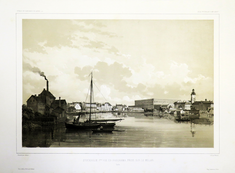
GAIMARD (Joseph-Paul);MAYER (Auguste).
[STOCKHOLM] Stockholm. 1ère vue en panorama, prise sur le Melar.
[1842-1856]. 312 x 400 mm.
Bookseller reference : LBW-4883
|
|
|
Galet, D. M
Lavater. [um 1850]. [Altkolorierte Original-Lithografie, gerahmt / original colored lithograph, framed]
o.J. [3 Warenabbildungen]
Bookseller reference : 59538BB

|
|
|
GALL Martin
"Le jeu de bridge; règles générales, différentes déclarations, manière de jouer à ""sans atout"" et s'il y a un atout nommé, parties jouées."
Paris, H. Delarue, s.d. (ca 1925). 12 x 19, 110 pp., broché, bon état.
Bookseller reference : 100.686
|
|
|
GALLOUEDEC L.
La Loire étude du fleuve
in 8 broché,couverture factice muette avec le premier plat de couverture,d’origine,contrecollé.Faux-titre,titre,347 pages,non coupé,4 cartes,42 graphiques.Hachette & Cie 1910
Bookseller reference : 8155
|
|
|
GALLOUEDEC L. - MAURETTE F. 76 illustrations en couleurs par H. de Renaucourt et 21 cartes.
Premier livre de géographie.
Couverture rigide. Cartonnage de l'éditeur. 46 pages. 20 x 25 cm. Couverture défraîchie. Rousseurs. Quelques graffitis.
Bookseller reference : 147474

|
|
|
Galtsoff, P. & Maps b & w Photos
The American Oyster Crassostrea Virginica Gmelin
U. S. Government Printing. Good with no dust jacket. 1964. Paperback. U. S. Government Printing paperback
Bookseller reference : 327401
|
|
|
Gamme Léon . Braverman Léo
Crimes et châtiments au bridge
Le bridgeur 1990
Bookseller reference : 497
|
|
|
Gancel Hippolyte
Une Normandie si étrange
OUEST FRANCE 2026 128 pages 19 5x25 5x1 2cm. 2026. Broché couverture rempliée. 128 pages. Ce livre explore la Normandie du début du XXe siècle à travers des pratiques métiers et traditions aujourd'hui disparus ou insolites comme la vigne normande le brûlage du varech les attelages de vaches ou le métier de langueyeur. Il s'appuie sur des cartes postales anciennes pour révéler un monde surprenant vieux de moins d'un siècle
Bookseller reference : 9109

|
|
|
GANDINI (Francesco);
[FLORENCE] Veduta del Duomo di Firenze.
circa 1830 114 x 190 mm.
Bookseller reference : LBW02e74
|
|
|
GANDINI (Francesco);
[FLORENCE] Veduta del ponte S. Trinità in Firenze.
circa 1830 114 x 191 mm.
Bookseller reference : LBW02e82
|
|
|
GANDINI (Francesco);
[FLORENCE] Veduta della piazza della SS. Annunziata in Firenze.
circa 1830 113 x 189 mm.
Bookseller reference : LBW02e83
|
|
|
GANDINI (Francesco);
[FLORENCE] Veduta della piazza di S. Trinità in Firenze.
circa 1830 113 x 189 mm.
Bookseller reference : LBW02e73
|
|
|
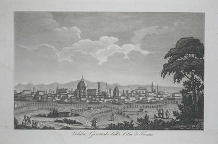
GANDINI (Francesco);
[FLORENCE] Veduta generale della città di Firenze.
circa 1830 121 x 194 mm.
Bookseller reference : LBW02e49
|
|
|
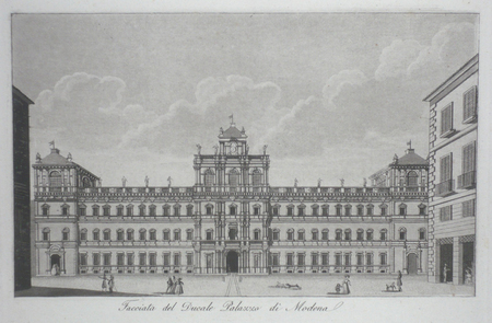
GANDINI (Francesco);
[MODENE] Facciata del Ducale Palazzo di Modena.
circa 1830 119 x 195 mm.
Bookseller reference : LBW02e75
|
|
|
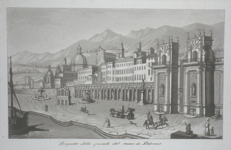
GANDINI (Francesco);
[PALERME] Prospetto della sponda del mare in Palermo.
circa 1830 118 x 194 mm.
Bookseller reference : LBW02e78
|
|
|
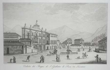
GANDINI (Francesco);
[PISE] Veduta dei Bagni di S. Giuliano di Pisa in Toscana.
circa 1830 115 x 190 mm.
Bookseller reference : LBW02e7f
|
|
|
GANDRIOT (Melle).
Carte de la commune Yzernay.
[circa 1810]. 400 x 535 mm, monté sur carton.
Bookseller reference : LBW-2823

|
|
|
Gannett, Henry (Arranged by).
LISTS OF ELEVATIONS PRINCIPALLY IN THAT PORTION OF THE UNITED STATES WEST OF THE MISSISSIPPI RIVER. Department of the Interior. U.S. Geological and Geographical Survey of the Territories. Miscellaneous Publications No. 1. Third Edition.
72p. 8vo. New wraps. NH 5
|
|
|
Gant, Frank
The Isle of Skye
No marks or inscriptions. Tiny crease to foot of spine. A very clean very tight copy with bright unmarked boards and no bumping to corners. 32pp. Guide to the Scottish Island.

|
|
|
GAP
Carte allemande couleurs au 1/200 000e.
Une feuille 56x80 cm.
|
|
|
GARCIA EDO, Vicente y GÓMEZ ALBIÑANA, Rosa María.
Cartografia Històrica de la Corona d'Aragó. Segles XVI a XVIII. Presentación de Francisco Toledo Lobo
Castellón, 2005. Folio; 219 pp., 1 h. Ilustraciones y Mapas. Edición limitada y numerada de 500 ejemplares. Encuadernación original en cartoné.

|
|
|
GARD
Carte d?partementale couleurs au 1/200 000?me. Sans date.
Une feuille. 56x76 cm.
|
|
|
Garland, Albert N. (Editor)
INFANTRY IN VIETNAM.
pp. 298 + Plus photographs. Numerous battle and combat diagrams and maps. 8vo. Original full cloth backed binding, stained. Reprint of the 1967 edition. Coldwar/Economics 1
|
|
|
Garland, G.D.
Continental Drift: The Royal Society of Canada Special Publications, No. 9
140 pages. Compiles contemporary research into the theory of continental drift. Usual library markings. Three maps contained in envelope inside back board. Average wear. Book
|
|
|
Garlick Mark A.; star maps by Wil Tirion
The Illustrated Atlas of the Universe
Used - Good. Used book that is in clean average condition without any missing pages. unknown
Bookseller reference : GRP72963547 ISBN : 1740893778 9781740893770
|
|
|
Garlick, Mark A.; star maps by Wil Tirion
The Illustrated Atlas of the Universe
Used - Good. Used book that is in clean average condition without any missing pages. unknown
Bookseller reference : GRP72963547 ISBN : 1740893778 9781740893770
|
|
|
Garlick, Mark A.; star maps by Wil Tirion
The Illustrated Atlas of the Universe
Used - Good. Former library book; may include library markings. Used book that is in clean average condition without any missing pages. unknown
Bookseller reference : GRP97424686 ISBN : 1740893778 9781740893770
|
|
 Receive by email
 Download as PDF document
 RSS feed


